Rome, Iowa | |
---|---|
Coordinates: 40°58′55″N91°40′54″W / 40.98194°N 91.68167°W | |
Country | United States |
State | Iowa |
County | Henry |
Area | |
• Total | 0.13 sq mi (0.32 km2) |
• Land | 0.12 sq mi (0.32 km2) |
• Water | 0.00 sq mi (0.00 km2) |
Elevation | 584 ft (178 m) |
Population (2020) | |
• Total | 114 |
• Density | 919.35/sq mi (353.75/km2) |
Time zone | UTC-6 (Central (CST)) |
• Summer (DST) | UTC-5 (CDT) |
ZIP code | 52642 |
Area code | 319 |
FIPS code | 19-68565 |
GNIS feature ID | 2396422 [2] |
Rome is a village in Henry County, Iowa, United States. The population was 114 at the time of the 2020 census. [3]
Rome was first laid out in 1846 by William Scott. In 1866, Rome annexed land across the Skunk River, in order to be connected to the Chicago, Burlington and Quincy Railroad. [4]
According to the United States Census Bureau, the village has a total area of 0.13 square miles (0.34 km2), all land. [5] The village is situated on the northwest bank of the Skunk River.
Year | Pop. | ±% |
---|---|---|
1880 | 276 | — |
1900 | 255 | −7.6% |
1910 | 155 | −39.2% |
1920 | 168 | +8.4% |
1930 | 144 | −14.3% |
1940 | 119 | −17.4% |
1950 | 134 | +12.6% |
1960 | 117 | −12.7% |
1970 | 135 | +15.4% |
1980 | 113 | −16.3% |
1990 | 124 | +9.7% |
2000 | 113 | −8.9% |
2010 | 117 | +3.5% |
2020 | 114 | −2.6% |
Source: "U.S. Census website". United States Census Bureau . Retrieved March 29, 2020. and Iowa Data Center Source: |
At the 2010 census, [7] there were 117 people, 52 households and 26 families living in the village. The population density was 900.0 inhabitants per square mile (347.5/km2). There were 54 housing units at an average density of 415.4 per square mile (160.4/km2). The racial makeup of the village was 97.4% White and 2.6% from other races. Hispanic or Latino of any race were 6.0% of the population.
There were 52 households, of which 23.1% had children under the age of 18 living with them, 34.6% were married couples living together, 5.8% had a female householder with no husband present, 9.6% had a male householder with no wife present, and 50.0% were non-families. 36.5% of all households were made up of individuals, and 13.4% had someone living alone who was 65 years of age or older. The average household size was 2.25 and the average family size was 3.00.
The median age in the village was 42.8 years. 17.1% of residents were under the age of 18; 15.4% were between the ages of 18 and 24; 19.7% were from 25 to 44; 33.4% were from 45 to 64; and 14.5% were 65 years of age or older. The gender makeup of the village was 50.4% male and 49.6% female.
At the 2000 census, [8] there were 113 people, 49 households and 27 families living in the village. The population density was 870.5 inhabitants per square mile (336.1/km2). There were 55 housing units at an average density of 423.7 per square mile (163.6/km2). The racial makeup of the village was 99.12% White, and 0.88% Native American.
There were 49 households, of which 26.5% had children under the age of 18 living with them, 38.8% were married couples living together, 14.3% had a female householder with no husband present, and 42.9% were non-families. 30.6% of all households were made up of individuals, and 4.1% had someone living alone who was 65 years of age or older. The average household size was 2.31 and the average family size was 2.82.
24.8% of the population were under the age of 18, 8.0% from 18 to 24, 34.5% from 25 to 44, 27.4% from 45 to 64, and 5.3% who were 65 years of age or older. The median age was 35 years. For every 100 females, there were 76.6 males. For every 100 females age 18 and over, there were 102.4 males.
The median household income was $22,083 and the median family income was $40,000. Males had a median income of $26,250 compared with $15,625 for females. The per capita income for the village was $12,976. There were 10.0% of families and 27.0% of the population living below the poverty line, including 18.2% of under eighteens and 50.0% of those over 64.
The Mount Pleasant Community School District operates local area public schools. [9]
Harpers Ferry is a city in Taylor Township, Allamakee County, Iowa, United States. The population was 262 at the time of the 2020 census.
Mount Auburn is a city in Benton County, Iowa, United States. The population was 162 at the time of the 2020 census. It is part of the Cedar Rapids Metropolitan Statistical Area.
Lidderdale is a city in Carroll County, Iowa, United States. The population was 166 at the time of the 2020 census. It was incorporated in 1906.
St. Olaf is a large village in Clayton County, Iowa, United States. The population was 106 at the time of the 2020 census, down from 136 in 2000. Swiss Valley has a large cheese packaging plant in St. Olaf. There is also a large feed granary, a post office, and a tavern.
Drakesville is a city in Davis County, Iowa, United States. The population was 164 at the time of the 2020 census.
Maynard is a city in Fayette County, Iowa, United States. The population was 476 at the time of the 2020 census.
Buckeye is a city in Hardin County, Iowa, United States. The population was 86 at the time of the 2020 census.
Williamsburg is a city in Iowa County, Iowa, United States. The population was 3,346 at the time of the 2020 census. Williamsburg is known for Holden's Foundation Seeds, a foundation seed corn company, and Kinze Manufacturing, Inc., a farm implement manufacturer. Aviation pioneer Eugene Ely was born outside Williamsburg.
Thornburg is a village in Keokuk County, Iowa, United States. The population was 45 at the time of the 2020 census. Its sole enterprise is the Tri-County Community School, a public school serving grades K-12.
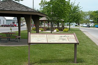
Carson is a city in Pottawattamie County, Iowa, United States. The population was 766 at the 2020 census. Carson has a number of interesting and historic places.
Montour is a city in Tama County, Iowa, United States. The population was 203 at the time of the 2020 census.
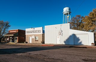
Sharpsburg is a city in Taylor County, Iowa, United States. The population was 72 at the time of the 2020 census.
Spring Hill is a city in Warren County, Iowa, United States. The population was 68 at the time of the 2020 census. It is part of the Des Moines–West Des Moines Metropolitan Statistical Area.
Vincent is a city in Webster County, Iowa, United States. The population was 130 at the time of the 2020 census.
Staplehurst is a village in Seward County, Nebraska, United States. It is part of the Lincoln, Nebraska Metropolitan Statistical Area. The population was 242 at the 2010 census.
Tennyson is a village in Grant County, Wisconsin, United States, originally called Dutch Hollow. The population was 355 at the 2010 census.
Avoca is a village in Iowa County, Wisconsin, United States. The population was 637 at the 2010 census. It is part of the Madison Metropolitan Statistical Area. It is named after Avoca in Ireland.
Bevington is a city in Madison and Warren Counties in the U.S. state of Iowa. The population was 57 at the 2020 census. It is part of the Des Moines–West Des Moines Metropolitan Statistical Area.
Montfort is a village in Grant and Iowa Counties in the U.S. state of Wisconsin. The population was 718 at the 2010 census. Of this, 622 were in Grant County, and 96 were in Iowa County.
Linden is a village in Iowa County, Wisconsin, United States. The population was 549 at the 2010 census. The village is located within the Town of Linden.