Ronald, Washington

Last updated

Ronald, Washington
Sh4 old school (8546431010).jpg
Former school in Ronald
Kittitas County Washington Incorporated and Unincorporated areas Ronald Highlighted.svg
Location of Ronald, Washington
Coordinates: 47°14′6″N121°1′36″W / 47.23500°N 121.02667°W / 47.23500; -121.02667
Country United States
State Washington
County Kittitas
Area
  Total0.93 sq mi (2.40 km2)
  Land0.93 sq mi (2.40 km2)
  Water0.0 sq mi (0.0 km2)
Elevation
2,349 ft (716 m)
Population
 (2010)
  Total308
  Density333/sq mi (128.5/km2)
Time zone UTC-8 (Pacific (PST))
  Summer (DST) UTC-7 (PDT)
ZIP code
98940
Area code 509
FIPS code 53-59635 [1]
GNIS feature ID1525199 [2]

Ronald is an unincorporated community and census-designated place (CDP) in Kittitas County, Washington, United States. The population was 308 at the 2010 census. [3]

Contents

Ronald was named for Alexander Ronald, a former coal mine superintendent in the area. [4]

Geography

Ronald is located in western Kittitas County at 47°14′6″N121°1′36″W / 47.23500°N 121.02667°W / 47.23500; -121.02667 (47.235096, -121.026613), [5] on the north side of the valley of the Cle Elum River. Washington State Route 903 passes through the community, leading southeast 5 miles (8 km) to Cle Elum and northwest 3 miles (5 km) to its end at Cle Elum Lake.

According to the United States Census Bureau, the Ronald CDP has a total area of 0.93 square miles (2.4 km2), all of it land. [3]

Climate

This region experiences warm (but not hot) and dry summers, with no average monthly temperatures above 71.6 °F. According to the Köppen Climate Classification system, Ronald has a warm-summer Mediterranean climate, abbreviated "Csb" on climate maps. [6]

Demographics

As of the census [1] of 2000, there were 265 people, 103 households, and 66 families residing in the CDP. The population density was 332.2 people per square mile (127.9/km2). There were 186 housing units at an average density of 233.2/sq mi (89.8/km2). The racial makeup of the CDP was 96.23% White, 1.13% African American, 1.51% Native American, 0.38% Asian, 0.38% from other races, and 0.38% from two or more races. Hispanic or Latino of any race were 2.64% of the population.

There were 103 households, out of which 32.0% had children under the age of 18 living with them, 46.6% were married couples living together, 13.6% had a female householder with no husband present, and 35.0% were non-families. 20.4% of all households were made up of individuals, and 13.6% had someone living alone who was 65 years of age or older. The average household size was 2.57 and the average family size was 3.01.

In the CDP, the population was spread out, with 26.0% under the age of 18, 4.9% from 18 to 24, 29.4% from 25 to 44, 22.6% from 45 to 64, and 17.0% who were 65 years of age or older. The median age was 40 years. For every 100 females, there were 96.3 males. For every 100 females age 18 and over, there were 92.2 males.

The median income for a household in the CDP was $39,063, and the median income for a family was $38,906. Males had a median income of $37,708 versus $20,500 for females. The per capita income for the CDP was $26,415. None of the families and 9.6% of the population were living below the poverty line.

Related Research Articles

<span class="mw-page-title-main">Kittitas County, Washington</span> County in Washington, United States

Kittitas County is a county located in the U.S. state of Washington. At the 2020 census, its population was 44,337. Its county seat and largest city is Ellensburg. The county was created in November 1883 when it was carved out of Yakima County. Kittitas County comprises the Ellensburg, Washington, Micropolitan Statistical Area.

<span class="mw-page-title-main">Lake Wildwood, California</span> Census-designated place in California, United States

Lake Wildwood is a census-designated place (CDP) in Nevada County, California, United States. The population was 4,991 at the 2010 census, up from 4,868 at the 2000 census.

<span class="mw-page-title-main">St. Pierre, Montana</span> Census-designated place in Montana, United States

St. Pierre is a census-designated place (CDP) in Hill County, Montana, United States, within the Rocky Boy Indian Reservation. The population of St. Pierre was 350 at the 2010 census, up from 289 in 2000.

<span class="mw-page-title-main">Ames Lake, Washington</span> Census-designated place in Washington, United States

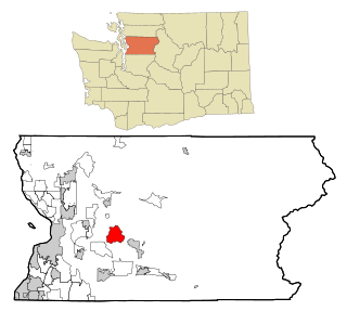
Ames Lake is an unincorporated community and census-designated place (CDP) in King County, Washington, United States. The population was 1,486 at the 2010 census.

<span class="mw-page-title-main">Baring, Washington</span> Census-designated place in Washington, United States

Baring is an unincorporated community and census-designated place (CDP) in King County, Washington, United States. The population was 220 at the 2010 United States Census. It is located on U.S. Highway 2 about 23 miles (37 km) west of Stevens Pass, along a very flat and straight three-mile section of highway that has been dubbed the "Baring Straight", since US-2 is otherwise hilly and curvy through the mountains. The settlement was first known as "Salmon", but by 1909 it was known as Baring.

<span class="mw-page-title-main">Hobart, Washington</span> Census-designated place in Washington, United States

Hobart is an unincorporated community and census-designated place (CDP) in King County, Washington, United States. The population was 6,767 at the 2020 census.

<span class="mw-page-title-main">Lake Marcel-Stillwater, Washington</span> Census-designated place in Washington, United States

Lake Marcel-Stillwater is a census-designated place (CDP) in King County, Washington, United States. The population was 1,277 at the 2010 census.

<span class="mw-page-title-main">Riverpoint, Washington</span> Census-designated place in Washington, United States

Riverpoint is an unincorporated community and census-designated place (CDP) in east King County, Washington, United States. As of the 2020 census, it had a population of 774. At the 2010 census, the area was listed as the Tanner CDP and had a population of 1,018 over a larger area.

<span class="mw-page-title-main">Cle Elum, Washington</span> City in Washington, United States

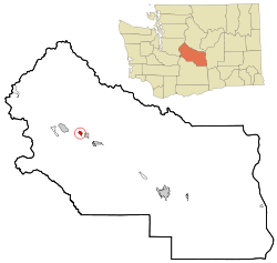
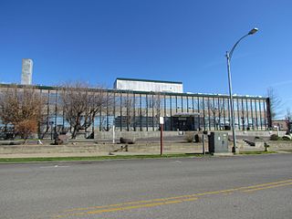
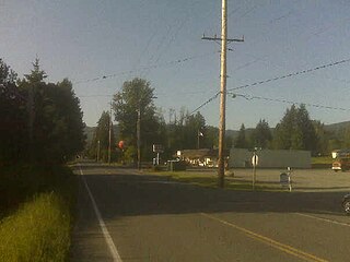
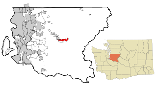
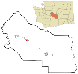
Cle Elum is a city in Kittitas County, Washington, United States. The population was 1,872 at the 2010 census. About 84 miles (135 km) by car from Seattle, Cle Elum is a popular area for camping and outdoor activities.

<span class="mw-page-title-main">Easton, Washington</span> Census-designated place in Washington, United States

Easton is an unincorporated community and census-designated place (CDP) in Kittitas County, Washington, United States. The population was 478 at the 2010 census.

<span class="mw-page-title-main">Kittitas, Washington</span> City in Washington, United States

Kittitas is a city in Kittitas County, Washington, United States. The population was 1,381 at the 2010 census and an estimated 1,493 in 2018.

<span class="mw-page-title-main">Roslyn, Washington</span> City in Washington, United States

Roslyn is a city in Kittitas County, Washington, United States. The population was 893 at the 2010 census. Roslyn is located in the Cascade Mountains, about 80 miles east of Seattle. The town was founded in 1886 as a coal mining company town. During the 20th century, the town gradually transitioned away from coal, and today its economy is primarily based on forestry and tourism. The town was the filming location for The Runner Stumbles, Northern Exposure, and The Man in the High Castle. Many of the town's historical structures have been preserved, and its downtown was added to the National Register of Historic Places in 1978.

<span class="mw-page-title-main">Snoqualmie Pass, Washington</span> Census-designated place in Washington, United States

Snoqualmie Pass is a census-designated place (CDP) in Kittitas County, Washington, United States. It includes the unincorporated community of Hyak. The population was 311 at the 2010 census.

<span class="mw-page-title-main">South Cle Elum, Washington</span> Town in Washington, United States

South Cle Elum is a town in Kittitas County, Washington, United States. The population was 532 at the 2010 census.

<span class="mw-page-title-main">Greenwater, Washington</span> CDP in Washington, United States

Greenwater is a census-designated place (CDP) in the northwest United States in Pierce County, Washington. Southeast of Seattle, the population was 67 at the 2010 census, down from 91 in 2000.

<span class="mw-page-title-main">Rockport, Washington</span> CDP in Washington, United States

Rockport is a census-designated place (CDP) in Skagit County, Washington, United States. The population was 109 at the 2010 census. It is included in the Mount Vernon–Anacortes, Washington Metropolitan Statistical Area.

<span class="mw-page-title-main">Lake Roesiger, Washington</span> CDP in Washington, United States

Lake Roesiger is a census-designated place (CDP) in Snohomish County, Washington, United States. The population was 503 at the 2010 census.

<span class="mw-page-title-main">May Creek, Washington</span> CDP in Washington, United States

May Creek is a census-designated place (CDP) in Snohomish County, Washington, United States. The population was 818 at the 2010 census.

<span class="mw-page-title-main">Three Lakes, Washington</span> CDP in Washington, United States

Three Lakes is a census-designated place (CDP) in Snohomish County, Washington, United States. The population was 3,184 at the 2010 census.

<span class="mw-page-title-main">Woods Creek, Washington</span> CDP in Washington, United States

Woods Creek is a census-designated place (CDP) in Snohomish County, Washington, United States. The population was 5,589 at the 2010 census.

References

  1. 1 2 "U.S. Census website". United States Census Bureau . Retrieved January 31, 2008.
  2. "Ronald". Geographic Names Information System . United States Geological Survey, United States Department of the Interior.
  3. 1 2 "Geographic Identifiers: 2010 Census Summary File 1 (G001), Ronald CDP, Washington". American FactFinder. U.S. Census Bureau. Archived from the original on February 13, 2020. Retrieved July 5, 2019.
  4. Meany, Edmond S. (1923). Origin of Washington geographic names. Seattle: University of Washington Press. p. 248.
  5. "US Gazetteer files: 2010, 2000, and 1990". United States Census Bureau. February 12, 2011. Retrieved April 23, 2011.
  6. Climate Summary for Ronald, Washington