Vantage, Washington

Last updated

Vantage, Washington
CDP
Kittitas County Washington Incorporated and Unincorporated areas Vantage Highlighted.svg
Location of Vantage in Washington
Coordinates: 46°56′48″N119°59′30″W / 46.94667°N 119.99167°W / 46.94667; -119.99167
Country United States
State Washington
County Kittitas
Area
  Total0.3 sq mi (0.8 km2)
  Land0.3 sq mi (0.8 km2)
  Water0.0 sq mi (0.0 km2)
Elevation
663 ft (202 m)
Population
 (2010)
  Total74
  Density246.7/sq mi (92.5/km2)
Time zone UTC-8 (Pacific (PST))
  Summer (DST) UTC-7 (PDT)
ZIP code
98950
Area code 509
FIPS code 53-74200 [1]
GNIS feature ID1511390 [2]

Vantage is a census-designated place (CDP) in Kittitas County, Washington, United States. The population was 74 at the 2010 census. [3]

Contents

History

The area around Vantage has been occupied by the Wanapum Native Americans since prehistory. A number of well-preserved rock-paintings have been found on the cliff walls. They also used the abundant petrified wood in the area for arrowheads and other tools. The site where these petroglyphs were found was inundated by the rising waters behind Wanapum Dam in the 1960s. About 60 of the more than 300 carvings were cut from the basalt cliff face and saved. [4] The nearby Ginkgo Petrified Forest site is one of the most unusual fossil forests in the world, and was designated a National Natural Landmark by the National Park Service in 1965. [5]

In the early part of the 20th century, residents in nearby Ellensburg needed a more direct route when traveling east. A small ferry was established in 1914 to carry vehicle traffic across the Columbia River at Vantage. This ferry was really just a small barge with wooden ramps at either end, it carried only two cars at a time across the river. After several cars (some with occupants still in them) were lost overboard, the state highway department decided to construct a bridge over the Columbia. [6] [7]

In 1927, the 1,640-foot (0.31 mi; 0.50 km) bridge was opened at Vantage. This was an important link in the Sunset Highway, the major east–west thoroughfare in Washington at the time (later U.S. Route 10, now Interstate 90). The construction of the bridge required workers to enter pressurized caissons seventy feet (21 m) under the riverbed via airlocks. Some workers became seriously ill from the effects of the pressure. Once completed, the bridge had a 70-foot (21 m) clearance on the center span, allowing for river traffic to pass under the bridge.

This cantilever bridge served at Vantage for 35 years, succeeded by the current bridge in 1962. The original was dismantled and moved to the crossing at Lyons Ferry, where it stands today as the oldest (95–96 years) extant steel cantilever bridge in Washington, and is listed in the National Register of Historic Places.

With completion of the Wanapum Dam in the early 1960s, the townsite was relocated further up the hill above the rising water to the current location. [5]

Geography

Vantage is located at 46°56′48″N119°59′30″W / 46.94667°N 119.99167°W / 46.94667; -119.99167 (46.946710, -119.991758) [8] along the Columbia River.

According to the United States Census Bureau, the CDP has a total area of 0.3 square miles (0.8 km2), all of it land.

The original town of Vantage was flooded by the Columbia River when the Wanapum Dam was placed into operation.

Vantage, WA, Columbia River crossing, I90.jpg
Interstate 90's Vantage crossing of the Columbia River in a 270° panorama from the north; Vantage is at the west end (right) of the bridge.

Climate

Climate data for Vantage
MonthJanFebMarAprMayJunJulAugSepOctNovDecYear
Record high °F (°C)69
(21)
71
(22)
82
(28)
96
(36)
105
(41)
109
(43)
113
(45)
115
(46)
103
(39)
89
(32)
75
(24)
70
(21)
115
(46)
Average high °F (°C)40
(4)
48
(9)
59
(15)
67
(19)
76
(24)
83
(28)
92
(33)
91
(33)
81
(27)
66
(19)
50
(10)
38
(3)
66
(19)
Average low °F (°C)26
(−3)
27
(−3)
32
(0)
38
(3)
46
(8)
53
(12)
58
(14)
56
(13)
47
(8)
37
(3)
30
(−1)
23
(−5)
39
(4)
Record low °F (°C)−28
(−33)
−24
(−31)
3
(−16)
21
(−6)
24
(−4)
34
(1)
41
(5)
39
(4)
26
(−3)
9
(−13)
−19
(−28)
−19
(−28)
−28
(−33)
Average precipitation inches (mm)0.92
(23)
0.65
(17)
0.71
(18)
0.57
(14)
0.51
(13)
0.59
(15)
0.27
(6.9)
0.18
(4.6)
0.32
(8.1)
0.60
(15)
1.08
(27)
1.18
(30)
7.58
(191.6)
[ citation needed ]

Demographics

As of the census [1] of 2000, there were 70 people, 25 households, and 20 families residing in the CDP. The population density was 219.7 inhabitants per square mile (84.8/km2). There were 39 housing units at an average density of 122.4 per square mile (47.3/km2). The racial makeup of the CDP was 22.86% White, 1.43% Pacific Islander, 2.86% from other races, and 11.43% from two or more races. Hispanic or Latino of any race were 84.29% of the population. Besides these populations, approximately 2,000 agricultural workers live in the Vantage area, and approximately 72.8% of are migratory.

There were 25 households, out of which 28.0% had children under the age of 18 living with them, 68.0% were married couples living together, 4.0% had a female householder with no husband present, and 20.0% were non-families. 20.0% of all households were made up of individuals, and none had someone living alone who was 65 years of age or older. The average household size was 2.80 and the average family size was 3.25.

In the CDP, the population was spread out, with 24.3% under the age of 18, 15.7% from 18 to 24, 21.4% from 25 to 44, 32.9% from 45 to 64, and 5.7% who were 65 years of age or older. The median age was 36 years. For every 100 females, there were 105.9 males. For every 100 females age 18 and over, there were 103.8 males.

The median income for a household in the CDP was $26,250, and the median income for a family was $43,750. Males had a median income of $26,250 versus $0 for females. The per capita income for the CDP was $17,605.

Business and recreation

Business

There are several gas stations, two restaurants, and a private RV park/campground in Vantage. The Wild Horse Wind Farm, owned by Puget Sound Energy, is located on ridge tops near Vantage. [9]

Recreation

Vantage is known for Ginkgo Petrified Forest State Park and its associated Wanapum Recreational Area, as a base camp for those attending nearby Gorge Amphitheatre, and its rock climbing. [10]

Rock climbing is one of the area's more popular forms of outdoor recreation and mostly takes place in "Echo Basin" (often mistaken for "Frenchman Coulee" which is the basin just north of Echo, on the other side of the Old Vantage Highway) on the basalt columns typical to the desert rimrock in the area.

Climbers started visiting as early as the 1950s and 1960s but the area was not popularized and publicized until the 1980s. With this came a great increase in route development. Today the area holds over 400 established routes (both traditionally protected and bolted) ranging in difficulty from 5.0-5.13c, and sees visitors almost year-round. [11]

Related Research Articles

<span class="mw-page-title-main">Okanogan County, Washington</span> County in Washington, United States

Okanogan County is a county located in the U.S. state of Washington along the Canada–U.S. border. As of the 2020 census, the population was 42,104. The county seat is Okanogan, while the largest city is Omak. Its area is the largest in the state.

<span class="mw-page-title-main">Grant County, Washington</span> County in Washington, United States

Grant County is a county located in the U.S. state of Washington. As of the 2020 census, the population was 99,123. The county seat is Ephrata, and the largest city is Moses Lake. The county was formed out of Douglas County in February 1909 and is named for U.S. President Ulysses S. Grant.

<span class="mw-page-title-main">Douglas County, Washington</span> County in Washington, United States

Douglas County is a county located in the U.S. state of Washington. As of the 2020 census, its population was 42,938. The county seat is Waterville, while its largest settlement is East Wenatchee. The county was created out of Lincoln County on November 28, 1883 and is named for American statesman Stephen A. Douglas.

<span class="mw-page-title-main">Parole, Maryland</span> Census-designated place in Maryland, United States

Parole, a suburb of Annapolis, is a census-designated place (CDP) in Anne Arundel County, Maryland, United States. The population was 15,922 at the 2010 census. It has several major roads intersect at the western edge of the state capital, Annapolis, and it contains the Annapolis Mall, a number of other large shopping centers, and the Anne Arundel Medical Center. It is generally considered to be part of Annapolis, rather than a separate town. The neighborhood was named because it was a parole camp, where Union and Confederate prisoners of war were brought for mutual exchange and eventual return to their respective homes.

<span class="mw-page-title-main">Sunnyslope, Washington</span> Census-designated place in Washington, United States

Sunnyslope is an unincorporated community and census-designated place (CDP) in Chelan County, Washington, United States. It is part of the Wenatchee–East Wenatchee Metropolitan Statistical Area. The population was 4,041 at the 2020 census, up from 3,252 at the 2010 census.

<span class="mw-page-title-main">Inchelium, Washington</span> CDP in Washington, United States

Inchelium is a census-designated place (CDP) in Ferry County, Washington, United States on the Colville Indian Reservation. The population was 431 at the 2020 Census.

<span class="mw-page-title-main">Banks Lake South, Washington</span> Census-designated place in Washington, United States

Banks Lake South is a census-designated place (CDP) in Grant County, Washington, United States. The population was 174 at the 2010 census.

<span class="mw-page-title-main">Coulee City, Washington</span> Town in Washington, United States

Coulee City is a town in Grant County, Washington. The population was 549 at the 2020 census.

<span class="mw-page-title-main">Desert Aire, Washington</span> Census-designated place in Washington, United States

Desert Aire is a census-designated place (CDP) in Grant County, Washington, United States. Desert Aire's elevation is 560 ft (170 m). The population was 1,626 at the 2010 census, up from 1,124 at the 2000 census.

<span class="mw-page-title-main">Easton, Washington</span> Census-designated place in Washington, United States

Easton is an unincorporated community and census-designated place (CDP) in Kittitas County, Washington, United States. The population was 478 at the 2010 census. Easton is the annual site of the start/finish line for the Cascade Crest 100-mile ultra-running race.

<span class="mw-page-title-main">Ronald, Washington</span> Census-designated place in Washington, United States

Ronald is an unincorporated community and census-designated place (CDP) in Kittitas County, Washington, United States. The population was 308 at the 2010 census.

<span class="mw-page-title-main">Snoqualmie Pass, Washington</span> Census-designated place in Washington, United States

Snoqualmie Pass is a census-designated place (CDP) in Kittitas County, Washington, United States. It includes the unincorporated community of Hyak. The population was 311 at the 2010 census.

<span class="mw-page-title-main">Dallesport, Washington</span> Census-designated place in Washington, United States

Dallesport is an unincorporated community and census-designated place (CDP) in Klickitat County, Washington, United States. The population was 1,328 at the 2020 census.

<span class="mw-page-title-main">Ashford, Washington</span> CDP in Washington, United States

Ashford is a census-designated place (CDP) mostly within Pierce County, Washington, United States. Its population was 217 as of the 2010 census. The town is west of the main entrance to Mount Rainier National Park. Surrounding mountains and the narrow Nisqually River valley are heavily forested. Some of Ashford is across the Nisqually River in Lewis County.

<span class="mw-page-title-main">Burbank, Washington</span> CDP in Washington, United States

Burbank is a census-designated place (CDP) in Walla Walla County, Washington, United States, where the Snake River meets the Columbia. The population was 3,291 at the 2010 census. Named for Luther Burbank, the city is located just east of Pasco and Kennewick, across the Snake and Columbia Rivers, respectively. Burbank is part of the Tri-Cities, WA urban area, despite being located in the Walla Walla metropolitan area.

<span class="mw-page-title-main">Alum Creek, West Virginia</span> Census-designated place in West Virginia, United States

Alum Creek is a census-designated place (CDP) in Kanawha and Lincoln counties along the Coal River in the U.S. state of West Virginia. It includes the unincorporated communities of Alum Creek, Forks of Coal, and Priestley. The CDP had a population of 1,749 at the 2010 census, down from 1,839 at the 2000 census.

<span class="mw-page-title-main">Ginkgo Petrified Forest State Park</span> State park in Washington state, United States

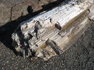
Ginkgo Petrified Forest State Park/Wanapum Recreational Area is a geologic preserve and public recreation area covering 7,124-acre (2,883 ha) on the western shoreline of the Columbia River's Wanapum Reservoir at Vantage, Washington. Petrified wood was discovered in the region in the early 1930s, which led to creation of the state park as a national historic preserve. Over 50 species are found petrified at the site, including ginkgo, sweetgum, redwood, Douglas-fir, walnut, spruce, elm, maple, horse chestnut, cottonwood, magnolia, madrone, sassafras, yew, and witch hazel.

<span class="mw-page-title-main">Carson, Washington</span> CDP in Washington, United States

Carson is a small census-designated place in the Columbia River Gorge National Scenic Area, north of the Columbia River in Skamania County, in the southwestern part of Washington, United States.

<span class="mw-page-title-main">Vantage Bridge</span> Bridge in Vantage, Washington

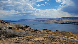
The Vantage Bridge is a bridge in the U.S. state of Washington. It carries Interstate 90 across the Columbia River, near Vantage and George, Washington. This section of the river is named Wanapum Lake; it is the reservoir formed by Wanapum Dam. The bridge separates the Ginkgo Petrified Forest and Wanapum Recreational Area State Park on the western bank of the Columbia.

Acer beckianum is an extinct maple species in the family Sapindaceae described from a single fossil wood section. The species is solely known from the Middle Miocene sediments exposed in central Washington in the United States. It is one of three Washington state Acer species described in 1961 from petrified wood.

References

  1. 1 2 "U.S. Census website". United States Census Bureau . Retrieved January 31, 2008.
  2. "Vantage". Geographic Names Information System . United States Geological Survey, United States Department of the Interior.
  3. "American FactFinder - Community Facts - Vantage CDP, Washington". factfinder.census.gov. U.S. Census Bureau. Archived from the original on February 14, 2020. Retrieved March 20, 2018.
  4. "Ginkgo Petrified Forest State Park".
  5. 1 2 "Kittitas County -- Thumbnail History".
  6. "Car ferry service across the Columbia River at Vantage begins in 1914".
  7. "New bridge over Columbia River at Vantage ferry". Spokane Daily Chronicle. (Washington). (photo). June 2, 1927. p. 1.
  8. "US Gazetteer files: 2010, 2000, and 1990". United States Census Bureau. February 12, 2011. Retrieved April 23, 2011.
  9. Wild Horse Wind Farm Archived 2007-09-28 at the Wayback Machine from the website of Horizon Wind Energy
  10. Entry for Frenchman Coulee from http://rockclimbing.com/
  11. Route references include "Rock Climbing Washington" by Jeff Smoot and "Frenchman Coulee" by Marlene Ford and Jim Yoder.