
Richland County is a county located in the U.S. state of Ohio. As of the 2020 census, the population was 124,936. Its county seat is Mansfield. The county was created in 1808 and later organized in 1813. It is named for the fertile soil found there.

Lucas is a village in southeastern Richland County, Ohio, United States. Lucas is part of the Mansfield, Ohio Metropolitan Statistical Area. The population was 589 at the 2020 census.

Mansfield is a city in and the county seat of Richland County, Ohio, United States. Located midway between Columbus and Cleveland via Interstate 71, it is part of Northeast Ohio region in the western foothills of the Allegheny Plateau. The 2020 Census showed that the city had a total population of 47,534, making it the 21st-largest city in Ohio. It lies approximately 65 miles (105 km) southwest of Cleveland, 45 miles (72 km) southwest of Akron and 65 miles (105 km) northeast of Columbus.
Ontario is a city in Richland County in the U.S. state of Ohio. It was founded in 1834 on the western edge of the Allegheny Plateau, just west of the city of Mansfield. After being incorporated in 1958, Ontario became a heavy manufacturing center because of the Erie Railroad line, and its proximity to Mansfield. However, its status in that regard began to decline in the late 20th century, when much of the Erie Railroad that once ran through the city was abandoned; and shifts in the manufacturing industry led to the relocation or repositioning of many factories. The city's industry has since diversified into the service economy, including education, finance and healthcare. The city is also a major regional retail hub serving the entire North-Central Ohio area, with a shopping population of over 150,000.

Butler Township is one of the eighteen townships of Richland County, Ohio, United States. It is a part of the Mansfield Metropolitan Statistical Area. The 2020 census found 1,167 people in the township.

Worthington Township is one of the eighteen townships of Richland County, Ohio, United States. It is a part of the Mansfield Metropolitan Statistical Area. The 2020 census found 2,988 people in the township.
Mifflin Township is one of the eighteen townships of Richland County, Ohio, United States. It is a part of the Mansfield Metropolitan Statistical Area. The 2020 census found 6,106 people in the township.

Washington Township is one of the eighteen townships of Richland County, Ohio, United States. It is a part of the Mansfield Metropolitan Statistical Area. The 2020 census found 6,622 people in the township.

Franklin Township is one of the eighteen townships of Richland County, Ohio, United States. It is a part of the Mansfield Metropolitan Statistical Area. The 2020 census found 1,679 people in the township.
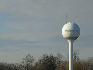
Madison Township is one of the eighteen townships of Richland County, Ohio, United States. It is a part of the Mansfield Metropolitan Statistical Area. The 2020 census found 11,106 people in the township.

Weller Township is one of the eighteen townships of Richland County, Ohio, United States. It is a part of the Mansfield Metropolitan Statistical Area. The 2020 census found 1,884 people in the township.

Springfield Township is one of the eighteen townships of Richland County, Ohio, United States. It is a part of the Mansfield Metropolitan Statistical Area. The 2020 census found 11,064 people in the township.

Jackson Township is one of the eighteen townships of Richland County, Ohio, United States. It is a part of the Mansfield Metropolitan Statistical Area. The 2020 census found 3,700 people in the township.

Jefferson Township is one of the eighteen townships of Richland County, Ohio, United States. It is a part of the Mansfield Metropolitan Statistical Area. The 2020 census found 4,905 people in the township.

Monroe Township is one of the eighteen townships of Richland County, Ohio, United States. It is a part of the Mansfield Metropolitan Statistical Area. The 2020 census found 2,721 people in the township.

Perry Township is one of the eighteen townships of Richland County, Ohio, United States. It is a part of the Mansfield Metropolitan Statistical Area. The 2020 census found 1,461 people in the township.

Sandusky Township is one of the eighteen townships of Richland County, Ohio, United States. It is a part of the Mansfield Metropolitan Statistical Area. The 2020 census found 1,002 people in the township.

Troy Township is one of the eighteen townships of Richland County, Ohio, United States. It is a part of the Mansfield Metropolitan Statistical Area. The 2020 census found 7,116 people in the township.
The Mansfield Metropolitan Statistical Area, as defined by the United States Census Bureau, is an area consisting of one county – Richland – in north central Ohio, anchored by the city of Mansfield. As of the 2020 census, the MSA had a population of 124,936. The MSA forms the eastern half of the Mansfield–Ashland–Bucyrus, OH CSA.
Lincoln Heights is an unincorporated area and census-designated place (CDP) in Richland County, Ohio, United States. It was first listed as a CDP prior to the 2020 census.


