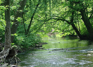
Haverford Township is a home rule municipality township in Delaware County, Pennsylvania, United States. Haverford is named after the town of Haverfordwest in Wales, United Kingdom. It is a commuting suburb located due west of Philadelphia and is officially known as the Township of Haverford. Despite being under a home rule charter since 1977, it continues to operate under a Board of Commissioners divided into wards, as do "First Class" townships that are still under the Pennsylvania Township Code. Haverford Township was founded in 1682 and incorporated in 1911.

Ardmore is an unincorporated community and census-designated place (CDP) spanning the border between Delaware and Montgomery counties in the U.S. state of Pennsylvania. The population was 12,455 at the time of the 2010 census and had risen to 13,566 in the 2020 census.
The Philadelphia Main Line, known simply as the Main Line, is an informally delineated historical and social region of suburban Philadelphia, Pennsylvania. Lying along the former Pennsylvania Railroad's once prestigious Main Line, it runs northwest from Center City Philadelphia parallel to Lancaster Avenue, also known as U.S. Route 30.

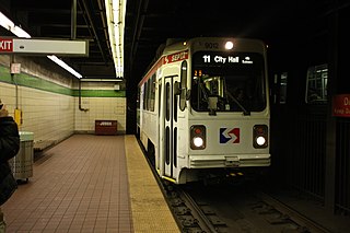
SEPTA Routes 101 and 102, also known as the Media–Sharon Hill Line, are light rail lines operated by the Suburban Transit Division of the Southeastern Pennsylvania Transportation Authority, serving portions of Delaware County. The routes' eastern terminus is 69th Street Transportation Center in Upper Darby Township, Pennsylvania. Route 101 runs to Media, while Route 102 goes to Sharon Hill. Altogether, the two lines operate on approximately 11.9 miles (19.2 km) of route. The lines were formerly interurbans.

The 69th Street Transportation Center is a SEPTA terminal in the Terminal Square section of Upper Darby Township, Pennsylvania. It serves the Market–Frankford Line, Norristown High Speed Line, and SEPTA Routes 101 and 102 trolleys, and multiple bus routes. It is located at the end of 69th Street, a major retail corridor in Upper Darby Township across Market Street from the Tower Theater. Until 2011, the station was primarily known as 69th Street Terminal.
The SEPTA subway–surface trolley lines are a collection of five SEPTA trolley lines that operate on street-level tracks in West Philadelphia and Delaware County, Pennsylvania, and also underneath Market Street in Philadelphia's Center City. The lines, Routes 10, 11, 13, 34, and 36, collectively operate on about 39.6 miles (63.7 km) of route.
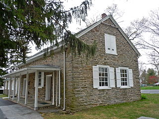
Havertown is a residential suburban unincorporated community in Haverford Township, Pennsylvania, United States. It is located approximately 9 miles west of the center of Philadelphia. Havertown's ZIP Code is 19083 and "Havertown" is a postal address. The name "Havertown" was coined by the U.S. Post Office and came into use on January 1, 1946. Before then, each constituent community was known by its local name: Bon Air, Brookline, Penfield, Beechwood, Llanerch, Manoa, Oakmont, Coopertown, and Ardmore. Under William Penn's land divisions these communities were part of the Welsh Tract and comprised the area known as Harford, a Welsh contraction of Haverford.

Wynnewood is a suburban unincorporated community, located west of Philadelphia, straddling Lower Merion Township in Montgomery County, Pennsylvania and Haverford Township in Delaware County, Pennsylvania, United States.
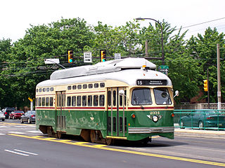
Route 15, the Girard Avenue Line, is a trolley line operated by the Southeastern Pennsylvania Transportation Authority (SEPTA) along Girard Avenue through North and West Philadelphia, Pennsylvania, United States. As of 2007, it is the only surface trolley line in the City Transit Division that is not part of the Subway–Surface Trolley Lines. SEPTA PCC II vehicles are used on the line.

Route 11, also known as the Woodland Avenue Line, is a trolley line operated by the Southeastern Pennsylvania Transportation Authority (SEPTA) that connects the 13th Street station in downtown Philadelphia, Pennsylvania, to Darby Transportation Center in Darby, Pennsylvania. It is one of five lines that are part of the subway–surface trolley system. Sitting at an average of 13,580 riders per weekday in 2019, it is the most used subway-surface trolley route, even though it lacks overnight service.

SEPTA Route 13, also known as the Chester Avenue Line, is a trolley line operated by the Southeastern Pennsylvania Transportation Authority (SEPTA) that connects 13th Street Station in downtown Philadelphia, Pennsylvania, with Yeadon and Darby, Pennsylvania. It is one of five lines that are part of the Subway-Surface Trolley system.

The Ardmore Junction station is a SEPTA transit station in Havertown, Pennsylvania. It serves the Norristown High Speed Line and SEPTA Route 103 bus.

SEPTA Route 10, also known as the Lancaster Avenue Line, is a trolley line operated by the Southeastern Pennsylvania Transportation Authority (SEPTA) that connects the 13th Street station in Center City Philadelphia, Pennsylvania, to the 63rd Street–Malvern Avenue station in the Overbrook section of West Philadelphia. It is one out of five lines that is part of the SEPTA's subway–surface trolley system and is 11.6 mi (18.7 km) long. It is the least used subway-surface trolley line, but unlike Route 11, the most used subway-surface trolley line, it has overnight service.

Pennsylvania Route 3 is a 24.3-mile (39.1 km) state highway located in the southeastern portion of Pennsylvania. The route runs from U.S. Route 322 Business in West Chester east to PA 611 in Philadelphia. The route begins in downtown West Chester and heads east out of the borough as a one-way pair of streets. Between West Chester and Upper Darby, PA 3 follows a four-lane divided highway named West Chester Pike through suburban areas. Along this stretch, the route passes through Edgmont, Newtown Square, Broomall, and Havertown. The route has an interchange with Interstate 476 (I-476) between Broomall and Havertown. Upon reaching Upper Darby, PA 3 heads into Philadelphia along Market Street. In Philadelphia, the route follows multiple one-way pairs, running along Chestnut Street eastbound and Walnut Street westbound in West Philadelphia before heading into Center City Philadelphia along Market Street eastbound and John F. Kennedy Boulevard westbound and ending at Philadelphia City Hall.
Route 104 is a bus route operated by SEPTA between Upper Darby's 69th Street Transportation Center and the North Campus of West Chester University in West Chester, Pennsylvania. Route 104 initially was a streetcar line which operated parallel to the West Chester Pike and was operated by the Philadelphia Suburban Transportation Company.
The City Transit Division of the Southeastern Pennsylvania Transportation Authority (SEPTA) operate almost all of Philadelphia's public transit, including all six trolley, three trackless trolley, and 70 bus lines within city limits. Some of the bordering municipalities are served by the City Transit division, despite not being part of the city. For example, Cheltenham Township has 13 city division routes and no Suburban Division ones. The City Transit division also operates the 400 Series routes which are designed to serve students attending schools in the city of Philadelphia.

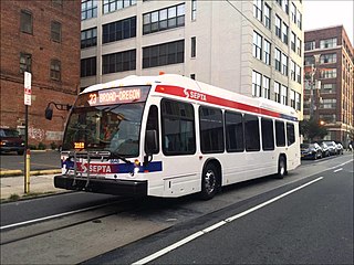
The Southeastern Pennsylvania Transportation Authority operates or contracts operations of these routes serving points in Bucks, Chester, Delaware, and Montgomery counties, with a few routes operating into the city of Philadelphia. The Suburban Transit Division is broken down into three districts: Victory, Frontier, and Contract Operations.

U.S. Route 13 (US 13) is a United States Numbered Highway running from Fayetteville, North Carolina, north to Morrisville, Pennsylvania. The route runs for 49.359 miles (79.436 km) through the Delaware Valley in the U.S. state of Pennsylvania. The route enters the state from Delaware in Marcus Hook, Delaware County. It continues northeast through Delaware County, passing through the city of Chester before heading through suburban areas along Chester Pike to Darby. US 13 enters the city of Philadelphia on Baltimore Avenue and runs through West Philadelphia to University City, where it turns north along several city streets before heading east across the Schuylkill River along Girard Avenue. The route turns north and heads to North Philadelphia, where it runs northeast along Hunting Park Avenue. US 13 becomes concurrent with US 1 on Roosevelt Boulevard, continuing into Northeast Philadelphia. US 13 splits southeast on a one-way pair of streets before heading northeast out of the city on Frankford Avenue. The route continues into Bucks County as Bristol Pike, heading northeast to Bristol, where it turns into a divided highway. US 13 becomes a freeway in Tullytown and continues north to its terminus at US 1 in Falls Township, near Morrisville. US 13 roughly parallels Interstate 95 (I-95) through its course in Pennsylvania.
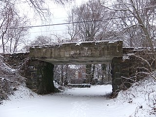
The Newtown Square Branch was a branch line of the Pennsylvania Railroad (PRR) that diverged from the West Chester Branch in Yeadon, Pennsylvania, and ended in Newtown Square, Pennsylvania. The rail line is mostly overgrown and few bridges remain, with the bridge over Baltimore Avenue located at the Upper Darby/East Lansdowne border having been removed in 2003. The only known presence of rails is at the junction just west of the SEPTA's Fernwood-Yeadon station. Through Upper Darby Township the former right-of-way follows PECO's high tension power lines from Fernwood to the Upper Darby/Haverford border at Lansdowne Avenue and Township Line Road.
Callowhill Depot is a bus and trolley barn operated by the Southeastern Pennsylvania Transportation Authority (SEPTA), located in West Philadelphia, near the Delaware County border. It was built in 1913 by the Philadelphia Rapid Transit Company (PRT) and was later operated by the Philadelphia Transportation Company (PTC) before being taken over by SEPTA. The depot was constructed as part of the Thomas E. Mitten modernization program. Since its construction, the depot has suffered fire damage and reconstruction in 1949, 1950, and 1995.


