SEPTA Route 13

Last updated
Route 13 (T3)
SEPTA T3 icon.svg
SEPTA K-car 9074 on the 13.jpg
SEPTA Route 13 makes one of its few
runs to the Darby Transportation Center.
Overview
Termini
Stations8 underground stations, 1 surface level station, and 39 street-level stops
Service
System Subway-Surface Trolley Lines
Depot(s) Elmwood Carhouse
Daily ridership13,364 (2019 average weekday)
Technical
Line length11.4 mi (18.3 km)[ citation needed ]
Track gauge 5 ft 2+14 in (1,581 mm) Pennsylvania trolley gauge [1] [2]
Electrification Overhead line,  600 V DC
Route map

Contents

BSicon tCONTg.svg
BSicon tSTR.svg
BSicon utCONTg.svg
SEPTA L icon.svg
BSicon tSTR.svg
BSicon HUBrg-R.svg
BSicon utdSTR+l.svg
BSicon cHUB-Lq.svg
BSicon HUB-Lq.svg
BSicon utINTACC.svg
BSicon utdSTR+r.svg
BSicon cHUB-Lq.svg
BSicon HUBlg-L.svg
13th Street
SEPTA L icon.svg
BSicon ulCONTg@Gq.svg
BSicon mtKRZt.svg
BSicon HUB-R.svg
BSicon utdKRZto.svg
BSicon utdKRZto.svg
BSicon utdKRZto.svg
BSicon XPLTa.svg
BSicon utSTRq.svg
BSicon utINTq.svg
BSicon HUB-L.svg
BSicon ucCONTfq.svg
BSicon HUB-R.svg
BSicon tSTR.svg
BSicon GRZ+l.svg
BSicon utSTR~L.svg
BSicon utINTACC-L.svg
BSicon HUBa@f-R.svg
BSicon HUB-Rq.svg
BSicon utSTR~R.svg
BSicon utINTACC-R.svg
BSicon HUBrf-L.svg
BSicon XPLTr.svg
15th Street
SEPTA L icon.svg
BSicon HUBe.svg
BSicon GRZe.svg
BSicon tINTACC.svg
BSicon utSTR.svg
BSicon utSTR~L.svg
BSicon utSTR.svg
BSicon utSTR~R.svg
BSicon htSTRe.svg
BSicon dNULf.svg
BSicon utdHST-L.svg
BSicon utdpHST-M.svg
BSicon dNULg.svg
BSicon utdHST-R.svg
19th Street
BSicon hSTR.svg
BSicon dNULf.svg
BSicon utdHST-L.svg
BSicon utdpHST-M.svg
BSicon dNULg.svg
BSicon utdHST-R.svg
22nd Street
BSicon hKRZW.svg
BSicon utdKRZW.svg
BSicon utdKRZW.svg
BSicon utdKRZW.svg
BSicon dWASSERq.svg
BSicon lCONTg@Gq.svg
BSicon lINTACC-Rq.svg
BSicon hKRZ.svg
BSicon umtdKRZ.svg
BSicon umtdKRZ.svg
BSicon umtdKRZ.svg
BSicon CONTfq.svg
BSicon hSTRe@f.svg
BSicon GRZa.svg
BSicon lINTACC-Lq.svg
BSicon utSTR.svg
BSicon utSTR~L.svg
BSicon utSTR.svg
BSicon utSTR~R.svg
BSicon STR.svg
BSicon GRZl.svg
BSicon utINTACC-L.svg
BSicon utSTR~L.svg
BSicon utINTACC-R.svg
BSicon utSTR~R.svg
30th Street
SEPTA L icon.svg
BSicon lCONTg@Gq.svg
BSicon KRZhl.svg
BSicon umtdKRZh.svg
BSicon umtdKRZh.svg
BSicon umtdKRZh.svg
BSicon hCONTfq.svg
BSicon tABZ3l.svg
BSicon lCONTf3.svg
BSicon PORTALa.svg
BSicon extSTR3+l.svg
BSicon umtdKRZtu.svg
BSicon tCONTfq.svg
BSicon utdSTRc2.svg
BSicon lMKRXo.svg
BSicon utvSHI2l-.svg
BSicon utv-SHI2+l.svg
BSicon utv-STR3.svg
BSicon utvSHI2r-.svg
BSicon ulCONTg@Gq.svg
BSicon utcdSTRr+1.svg
BSicon utdSTRc4.svg
BSicon utdSTR.svg
SEPTA L icon.svg
BSicon utHST.svg
33rd Street
BSicon PORTALl.svg
BSicon uCONTg@Gq.svg
BSicon utABZgr.svg
SEPTA T1 icon.svg
BSicon utHST.svg
36th Street
BSicon utHST.svg
37th Street
BSicon utHSTe@g.svg
40th Street Portal
BSicon uCONTgq.svg
BSicon uSTR+r.svg
BSicon uKRWgr.svg
SEPTA T2 icon.svg Baltimore Avenue
BSicon ueHST.svg
Chester & Woodland
BSicon uABZgl.svg
BSicon udSTRq.svg
BSicon uLSTR+r.svg
SEPTA T4 icon.svg SEPTA T5 icon.svg Woodland Avenue
BSicon ueBHF(L)g.svg
BSicon uLSTRe.svg
Chester & 41st
BSicon uCONTgq.svg
BSicon uHST.svg
BSicon uKRZ+r.svg
BSicon uCONTfq.svg
Chester & 42nd
Diversion tracks to 40th and Market
BSicon uHST.svg
Chester & 43rd
BSicon uHST.svg
Chester & 45th
BSicon uHST.svg
Chester & 46th
BSicon uHST.svg
Chester & 47th
BSicon uHST.svg
Chester & 48th
BSicon uCONTgq.svg
BSicon HUB2.svg
BSicon uHST.svg
BSicon uKRZl+l.svg
BSicon HUBc3.svg
BSicon uCONTfq.svg
Chester & 49th
Non-Revenue Track
BSicon CONTgq.svg
BSicon HUBc1.svg
BSicon umKRZo.svg
BSicon HUB4.svg
BSicon BHFq.svg
BSicon lCONTf@Gq.svg
BSicon uHST.svg
Chester & 51st
BSicon uHST.svg
Chester & 52nd
BSicon uHST.svg
Chester & 53rd
BSicon uHST.svg
Chester & 54th
BSicon uHST.svg
Chester & 55th
BSicon uHST.svg
Chester & 56th
BSicon uHST.svg
Chester & 57th
BSicon uHST.svg
BSicon uABZgl+l.svg
BSicon uCONTfq.svg
Chester & 58th
Non-Revenue Track to Woodland Ave.
BSicon uHST.svg
Chester & 59th
BSicon uHST.svg
Chester & 60th
BSicon uHST.svg
Kingsessing & 60th
BSicon uHST.svg
Kingsessing & 61st
BSicon uHST.svg
Kingsessing & 62nd
BSicon uHST.svg
BSicon uWSLgr.svg
Mount Moriah
BSicon uHST.svg
Kingsessing & 65th
BSicon uHST.svg
65th & Chester
BSicon uHST.svg
65th & Belmar
BSicon ueHST.svg
65th & Windsor
BSicon ueHST.svg
65th & Cobbs Creek
BSicon uWBRUCKE1.svg
BSicon uHST.svg
65th & Chester
BSicon uHST.svg
Chester & Church
BSicon uHST.svg
Chester & Yeadon
BSicon uHST.svg
Chester & Duncan
BSicon uHST.svg
Chester & Stetser
BSicon uKRW+l.svg
BSicon uSTR+r.svg
BSicon uKRWgr.svg
Yeadon Loop
BSicon ulHST~L.svg
BSicon uSTRl.svg
BSicon ulHST~R.svg
BSicon uSTR+r.svg
BSicon uABZgr.svg
Pfeil unten.svg Limited service
BSicon uHST.svg
Chester & Alfred
BSicon uBHF(R)f.svg
Chester & Cedar
BSicon udSTR+l.svg
BSicon udABZlr.svg
BSicon udSTR+r.svg
10th │ 9th
BSicon uSTRf.svg
BSicon uHSTg.svg
Cedar
BSicon uHSTf.svg
BSicon uSTRg.svg
Mulberry
BSicon uHSTf.svg
BSicon uSTRg.svg
Wycombe
BSicon uSTRf.svg
BSicon uHSTg.svg
Summit MBFS
BSicon uHSTf.svg
BSicon uHSTg.svg
Summit
BSicon uHSTf.svg
BSicon uHSTg.svg
Ridge
BSicon uHSTf.svg
BSicon uSTRg.svg
BSicon uLSTRa.svg
Main
BSicon udSTR+l-.svg
BSicon udSTR.svg
BSicon udSTRq-.svg
BSicon udSTR+r-.svg
BSicon udSTR.svg
BSicon udLSTR.svg
BSicon uSTRf.svg
BSicon uHSTg.svg
BSicon uLSTR.svg
Main MBFS
BSicon udSTRl-.svg
BSicon dNULfq-.svg
BSicon udHSTq-.svg
BSicon udSTRq-.svg
BSicon udSTRl-.svg
BSicon udSTRq-.svg
BSicon udSTRr-.svg
Darby T.C. SEPTA T4 icon.svg

SEPTA Route 13, also known as the Chester Avenue Line, is a trolley line operated by the Southeastern Pennsylvania Transportation Authority (SEPTA) that connects 13th Street Station in downtown Philadelphia, Pennsylvania, with Yeadon and Darby, Pennsylvania. It is one of five lines that are part of the Subway-Surface Trolley system. Route 13 will be rebranded as the T3 as part of the transition to SEPTA Metro.

Route description

Starting from its eastern end at the 13th Street, Route 13 runs in a tunnel under Market Street. It makes stops at underground stations at 15th Street, 19th Street, 22nd Street, 30th Street, and 33rd Street. From 15th to 30th Streets, it runs on the outer tracks in the same tunnel as SEPTA's Market–Frankford Line.

Passengers may transfer free of charge to the Market–Frankford Line at 13th, 15th, and 30th Streets and to the Broad Street Line at 15th Street. Connections to the SEPTA Regional Rail are also available. Underground passageways connect the 13th and 15th Street Stations to Jefferson Station and Suburban Station.

Route 13 surfaces at the 40th Street Portal near 40th Street and Baltimore Avenue (US 13), and then runs southwest along Woodland Avenue shortly before moving to Chester Avenue. An alternate trolley line existing along 42nd Street itself joins the Route 13 line for several blocks. This line is used when tunnels are closed for maintenance or other unforeseen shutdowns. The line runs on a bridge over the Media/Wawa Line at 49th Street, however, it does not serve as an official stop for the trolley. The alternate trolley line for tunnel closings turns along 49th Street itself before Route 13 crosses the 49th Street Station railroad bridge, although some Route 11 trolleys use these tracks.

Mt. Moriah Cemetery cuts off Chester Avenue, so the line makes a left turn at 60th Street then returns to the southwest at Kingsessing Avenue. At the southwest corner of the cemetery, the Route 13 line stops at the Mt. Moriah Loop, and some use the loop for trolleys that do not go to either Yeadon or Darby. For those that do, the trolleys continue west on Kingsessing Avenue until it reaches 65th Street, where it turns north, and later northwest as it approaches a bridge over the Cobbs Creek Parkway, and immediately turns on another section of Chester Avenue, on its way to the Yeadon Loop. Fernwood-Yeadon (SEPTA station) is further north of this terminus and has no connection. However the SEPTA Suburban Bus Routes 68 and 108, which do lead to Fernwood-Yeadon cross the line east of Yeadon Loop at the Church Lane intersection.

West of Yeadon Loop, some trolleys continue along the Chester Avenue line until it reaches Cedar Avenue, where westbound and eastbound trolley lines split along 10th Street and 9th Street respectively. The tracks on 10th Street run straight, while those on 9th Street briefly run along Summit Street. As the westbound tracks turn left at the terminus of the 10th and Main Streets intersection, it runs south to the next block at Darby Transportation Center, which is primarily served by the SEPTA Route 11 line, as well as numerous buses.

History

Trolley service on Route 13 originally operated from Yeadon to Front & Chestnut Streets via Chestnut and Walnut Streets. Service was rerouted into the Subway-Surface Tunnel on September 9, 1956.[ citation needed ]

Service to was extended to Darby following the discontinuation of the Route 62 Darby–Yeadon shuttle trolley on January 24, 1971.[ citation needed ]

In 2021, SEPTA proposed rebranding their rail transit service as "SEPTA Metro", in order to make the system easier to navigate. Under this proposal, the subway–surface lines will be rebranded as the "T" lines with a green color and numeric suffixes for each service, and Route 13 would be renamed "T3 Chester Avenue." [3] [4] SEPTA described that "most comments were positive" in the public comment period for this rebranding project. [5]

Stations and stops

All are in the City of Philadelphia or the boroughs of Yeadon or Darby.

Neighborhood/
location
ImagesStation or stopConnectionsNotes
Market East 13th Street trolley 1.jpg 13th Street SEPTA.svg BSicon SUBWAY.svg   MFL   Market–Frankford Line
SEPTA.svg BSicon TRAM.svg 10, 11, 13, 34, 36
SEPTA.svg Bus-logo.svg 27, 31, 32
Closed between 12:30–5:00am
Penn Center 15th Street SEPTA 2018 trolley.JPG 15th Street SEPTA.svg Aiga railtransportation 25.svg all lines (at Suburban)
SEPTA.svg BSicon SUBWAY.svg   MFL   Market–Frankford Line,   BSL   Broad Street Line (at City Hall)
SEPTA.svg BSicon TRAM.svg 10, 11, 13, 34, 36
SEPTA.svg Bus-logo.svg 4, 16, 17, 27, 31, 32, 33, 38, 44, 48
SEPTA.svg BSicon BUS2.svg 124, 125
Late night terminus
SEPTA Subway-Surface underground.jpg 19th Street SEPTA.svg BSicon TRAM.svg 10, 11, 13, 34, 36
SEPTA.svg Bus-logo.svg 17, 31, 38, 44, 48, 62, 78
SEPTA.svg BSicon BUS2.svg 124
Center City West 22nd Street trolley station Philadelphia.jpg 22nd Street SEPTA.svg BSicon TRAM.svg 10, 11, 13, 34, 36
SEPTA.svg Bus-logo.svg 7, 31, 44, 62
SEPTA.svg BSicon BUS2.svg 124, 125
Replaced 24th Street station
University City 30th Street Trolley Station 2.jpg Drexel Station at 30th Street BSicon LOGO Amtrak2.svg Amtrak (at 30th Street)
NJT logo.svg NJ Transit: ACL Atlantic City Line (at 30th Street)
SEPTA.svg Aiga railtransportation 25.svg all lines (at 30th Street)
SEPTA Metro.svg BSicon SUBWAY.svg SEPTA L icon.svg Market–Frankford Line
SEPTA.svg BSicon TRAM.svg 10, 11, 13, 34, 36
SEPTA.svg Bus-logo.svg 31, 49, LUCY
No direct passage to 30th Street Station
33rd Street station SEPTA 2018a.jpg 33rd Street SEPTA.svg BSicon TRAM.svg 10, 11, 13, 34, 36
SEPTA.svg Bus-logo.svg 30, 31, 49, LUCY
Serves Drexel University
36th Street Station SEPTA.jpg 36th Street SEPTA.svg BSicon TRAM.svg 11 , 34 , 36
SEPTA.svg Bus-logo.svg 21
Serves University of Pennsylvania
37th Street Station 2018c.jpg 37th Street SEPTA.svg BSicon TRAM.svg 11 , 34 , 36
SEPTA.svg Bus-logo.svg 40 , 42 , LUCY
Serves University of Pennsylvania, Children's Hospital of Philadelphia
Spruce Hill SEPTA K-Car Subway Surface.jpg 40th Street Portal SEPTA.svg BSicon TRAM.svg 11 , 34 , 36
SEPTA.svg Bus-logo.svg 30 , 40 , 42 , LUCY
End of Route 34 concurrency
Chester & WoodlandDiscontinued; end of 11 & 36 concurrency
41st & Chester (EB)Discontinued
42nd and Chester.jpg 42nd & Chester SEPTA.svg Bus-logo.svg 30
43rd & Chester
45th & Chester
46th & Chester
Squirrel Hill 47th & Chester
48th & Chester
Chester49.jpg 49th & Chester SEPTA.svg Aiga railtransportation 25.svg       Media/Wawa Line (at 49th Street)
SEPTA.svg Bus-logo.svg 64
Kingsessing 51st & Chester
52nd & Chester
53rd & Chester
54th & Chester SEPTA.svg Bus-logo.svg 52
55th & Chester
56th & Chester
57th & Chester
Chester58.jpg 58th & Chester SEPTA.svg Bus-logo.svg G
Mount Moriah 59th & Chester
Chester & 60th
60th & Kingsessing
61st & Kingsessing
62nd & Kingsessing
WTP2 mblumber moriah station.JPG Mount Moriah
Elmwood 65th & Kingsessing
Chester & 65th
Belmar & 65th
Windsor & 65th
Cobbs Creek & 65th
Philadelphia–Yeadon line
Yeadon 65th & Chester
Church & Chester SEPTA.svg Bus-logo.svg 68
SEPTA.svg BSicon BUS2.svg 108
Yeadon & Chester
Duncan & Chester
Stetser & Chester
Yeadon Loop-Trolley Shelter.JPG Yeadon Loop
Alfred & ChesterLimited service
Cedar & ChesterLimited service
Yeadon–Darby line
Darby Cedar & 9th (EB)
Mulberry & 10th (WB)
Limited service
Summit & 9th (EB)
Wycombe & 10th (WB)
Limited service
Summit & 10th (WB)
Summit & 9th (EB)
Limited service
Ridge & 10th (WB)
Ridge & 9th (EB)
Limited service
Main & 10th (WB)Limited service
SEPTA LRV at Darby, June 2008.jpg Darby T.C. SEPTA.svg BSicon TRAM.svg 11
SEPTA.svg BSicon BUS2.svg 113 , 114 , 115
Limited service

Related Research Articles

<span class="mw-page-title-main">Market–Frankford Line</span> SEPTA rapid transit line in Philadelphia, Pennsylvania

The Market–Frankford Line (MFL), currently rebranding as the L, is a rapid transit line in the SEPTA Metro network in Philadelphia, Pennsylvania, United States. The MFL runs from the 69th Street Transportation Center in Upper Darby, just outside of West Philadelphia, through Center City Philadelphia to the Frankford Transportation Center in Near Northeast Philadelphia. Starting in 2024, the line was rebranded as the "L" as part of the implementation of SEPTA Metro, wherein line names are simplified to a single letter.

<span class="mw-page-title-main">69th Street Transportation Center</span> Rapid transit station in Philadelphia

The 69th Street Transportation Center is a SEPTA terminal in the Terminal Square section of Upper Darby Township, Pennsylvania. It serves the Market–Frankford Line, Norristown High Speed Line, and SEPTA Routes 101 and 102 trolleys, and multiple bus routes. It is located at the end of 69th Street, a major retail corridor in Upper Darby Township across Market Street from the Tower Theater. Until 2011, the station was primarily known as 69th Street Terminal.

<span class="mw-page-title-main">West Philadelphia</span> Neighborhood of Philadelphia, Pennsylvania

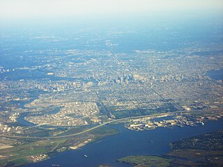
West Philadelphia, nicknamed West Philly, is a section of the city of Philadelphia. Although there are no officially defined boundaries, it is generally considered to reach from the western shore of the Schuylkill River, to City Avenue to the northwest, Cobbs Creek to the southwest, and the SEPTA Media/Wawa Line to the south. An alternate definition includes all city land west of the Schuylkill; this would also include Southwest Philadelphia and its neighborhoods. The eastern side of West Philadelphia is also known as University City.

<span class="mw-page-title-main">SEPTA subway–surface trolley lines</span> Philadelphia trolley lines

The SEPTA subway–surface trolley lines are a collection of five SEPTA trolley lines that operate on street-level tracks in West Philadelphia and Delaware County, Pennsylvania, and also underneath Market Street in Philadelphia's Center City. The lines, Routes 10, 11, 13, 34, and 36, collectively operate on about 39.6 miles (63.7 km) of route.

<span class="mw-page-title-main">SEPTA Route 15</span> SEPTA trolley line in Philadelphia, Pennsylvania

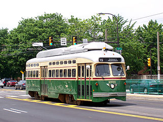
Route 15, the Girard Avenue Line, is a trolley line operated by the Southeastern Pennsylvania Transportation Authority (SEPTA) along Girard Avenue through North and West Philadelphia, Pennsylvania, United States. As of 2007, it is the only surface trolley line in the City Transit Division that is not part of the Subway–Surface Trolley Lines. SEPTA PCC II vehicles are used on the line.

<span class="mw-page-title-main">15th Street station (SEPTA)</span> Rapid transit station in Philadelphia

15th Street station is a subway station in Philadelphia. It is served by SEPTA's Market–Frankford Line and all routes of the subway–surface trolley lines. A free interchange also provides access to the Broad Street Line at City Hall station, which is connected to 15th Street by the Downtown Link underground concourse. The concourse also connects to Regional Rail lines at Suburban Station. It is the busiest station on the Market–Frankford Line, with 29,905 boardings on an average weekday.

<span class="mw-page-title-main">49th Street station (SEPTA Regional Rail)</span> SEPTA Regional Rail station in Philadelphia

49th Street station is a SEPTA Regional Rail station in Philadelphia. It is located at 1104 South 49th Street in the Kingsessing section of Southwest Philadelphia, and serves the Media/Wawa Line. In 2013, this station saw 62 boardings and 52 alightings on an average weekday.

<span class="mw-page-title-main">Fernwood–Yeadon station</span>

Fernwood–Yeadon station is a SEPTA Regional Rail station in Yeadon, Pennsylvania. It serves the Media/Wawa Line and is located at Church Lane and Penn Boulevard. The station saw 113 boardings and 132 alightings on an average weekday. The station originally had a wooden pedestrian bridge and a grade crossing.

<span class="mw-page-title-main">SEPTA Route 11</span> Philadelphia trolley line

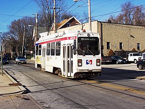
Route 11, also known as the Woodland Avenue Line, is a trolley line operated by the Southeastern Pennsylvania Transportation Authority (SEPTA) that connects the 13th Street station in downtown Philadelphia, Pennsylvania, to Darby Transportation Center in Darby, Pennsylvania. It is one of five lines that are part of the subway–surface trolley system. Sitting at an average of 13,580 riders per weekday in 2019, it is the most used subway-surface trolley route, even though it lacks overnight service. This route will be rebranded as the T4 as part of the transition to SEPTA Metro.

<span class="mw-page-title-main">40th Street Portal</span> SEPTA Subway-Surface Lines trolley station

The 40th Street Portal, also known as simply 40th Street station, is a SEPTA Subway-Surface Lines trolley station in Philadelphia. At this station's portal, four of the five Subway-Surface Lines enter the Woodland Avenue subway tunnel after running on the street in Southwest Philadelphia and nearby suburbs. Eastbound trolleys run in the tunnel under the nearby campuses of the University of Pennsylvania and Drexel University to Center City Philadelphia. Westbound trolleys travel to the Philadelphia neighborhoods of Eastwick and Angora and the Delaware County suburbs of Yeadon and Darby.

<span class="mw-page-title-main">SEPTA Route 34</span> Trolley line in Philadelphia, Pennsylvania

SEPTA's subway–surface trolley route 34, also called the Baltimore Avenue subway line, is a trolley line operated by the Southeastern Pennsylvania Transportation Authority (SEPTA) that connects the 13th Street station in downtown Philadelphia, Pennsylvania, to the Angora Loop station in the Angora neighborhood of West Philadelphia. Route 34 will be rebranded as the T2 as part of the transition to SEPTA Metro.

<span class="mw-page-title-main">SEPTA Route 36</span> Philadelphia trolley line

SEPTA's Subway-Surface Trolley Route 36 is a trolley line operated by the Southeastern Pennsylvania Transportation Authority (SEPTA) that connects the 13th Street station in downtown Philadelphia, Pennsylvania, to the Eastwick Loop station in Eastwick section of Southwest Philadelphia, although limited service is available to the Elmwood Carhouse. It is the longest of the five lines that are part of the Subway-Surface Trolley system, and was even longer between 1956 and 1962 when the western terminus was at 94th Street and Eastwick Avenue. From 1962 through the 1970s, it was at 88th Street and Eastwick Avenue, making the route 16.2 miles (26.1 km) long. Since 1975, it only goes as far as what was once 80th Street at the southern edge of the Penrose Plaza shopping center parking lot. Route 36 will be rebranded as the T5 as part of the transition to SEPTA Metro.

<span class="mw-page-title-main">Mount Moriah station</span> Tram stop in Philadelphia

Mount Moriah station is a trolley stop on the SEPTA subway–surface 13 trolley in Southwest Philadelphia.

<span class="mw-page-title-main">SEPTA Route 10</span> Philadelphia trolley line

SEPTA Route 10, also known as the Lancaster Avenue Line, to be known as the T1 after rebrand, is a trolley line operated by the Southeastern Pennsylvania Transportation Authority (SEPTA) that connects the 13th Street station in Center City Philadelphia, Pennsylvania, to the 63rd Street–Malvern Avenue station in the Overbrook section of West Philadelphia. It is one out of five lines that is part of the SEPTA's subway–surface trolley system and is 11.6 mi (18.7 km) long. It is the least used subway-surface trolley line, but unlike Route 11, the most used subway-surface trolley line, it has overnight service.

<span class="mw-page-title-main">13th Street station (SEPTA)</span> Rapid transit station in Philadelphia

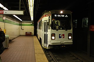
13th Street station is a SEPTA subway station in Philadelphia, Pennsylvania, located under Market Street between 13th and Juniper Streets in Center City. The station serves the Market–Frankford Line and is the eastern terminal station for all five routes of the subway–surface trolley lines.

<span class="mw-page-title-main">19th Street station (SEPTA)</span> Subway station in Philadelphia, Pennsylvania

19th Street station is an underground trolley station in Philadelphia. It is located underneath Market Street in Center City Philadelphia, and serves all routes of the SEPTA subway–surface trolley lines. The station was opened by the Philadelphia Transportation Company in 1907.

<span class="mw-page-title-main">22nd Street station (SEPTA)</span> Underground trolley station in Philadelphia, Pennsylvania

22nd Street station is an underground trolley station in Center City, Philadelphia that serves the SEPTA Subway–Surface Trolley Lines. Similar to 19th Street station, three blocks east of it, the station has two side platforms and a total of four tracks. The station serves only subway–surface trolleys on the two outer tracks; the Market-Frankford Line subway uses the two inner tracks and bypasses the station as it travels between 15th Street and 30th Street station.

<span class="mw-page-title-main">Pennsylvania Route 3</span> State highway in Chester, Delaware, and Philadelphia counties in Pennsylvania, US

Pennsylvania Route 3 is a 24.3-mile (39.1 km) state highway located in the southeastern portion of Pennsylvania. The route runs from U.S. Route 322 Business in West Chester east to PA 611 in Philadelphia.

<span class="mw-page-title-main">Southwest Philadelphia</span> Neighborhood of Philadelphia in Philadelphia, Pennsylvania

Southwest Philadelphia is a section of Philadelphia, Pennsylvania, United States. The section can be described as extending from the western side of the Schuylkill River to the city line, with the SEPTA. The northern border is defined by the Philadelphia City Planning Commission as east from the city line along Baltimore Avenue moving south along 51st Street to Springfield Ave. It follows the train tracks until 49th Street. From 49th and Kingsessing Ave the line moves east along Kingsessing Ave. The line then moves south along 46th St to Paschall Ave where it jogs to join Grays Ferry where the line runs to the Schuylkill River.

<span class="mw-page-title-main">U.S. Route 13 in Pennsylvania</span> Highway in Pennsylvania

U.S. Route 13 (US 13) is a United States Numbered Highway running from Fayetteville, North Carolina, north to Morrisville, Pennsylvania. The route runs for 49.359 miles (79.436 km) through the Delaware Valley in the U.S. state of Pennsylvania. The route enters the state from Delaware in Marcus Hook, Delaware County. It continues northeast through Delaware County, passing through the city of Chester before heading through suburban areas along Chester Pike to Darby. US 13 enters the city of Philadelphia on Baltimore Avenue and runs through West Philadelphia to University City, where it turns north along several city streets before heading east across the Schuylkill River along Girard Avenue. The route turns north and heads to North Philadelphia, where it runs northeast along Hunting Park Avenue. US 13 becomes concurrent with US 1 on Roosevelt Boulevard, continuing into Northeast Philadelphia. US 13 splits southeast on a one-way pair of streets before heading northeast out of the city on Frankford Avenue. The route continues into Bucks County as Bristol Pike, heading northeast to Bristol, where it turns into a divided highway. US 13 becomes a freeway in Tullytown and continues north to its terminus at US 1 in Falls Township, near Morrisville. US 13 roughly parallels Interstate 95 (I-95) through its course in Pennsylvania.

References

  1. "The history of trolley cars and routes in Philadelphia". SEPTA. 1974-06-01. p. 2. Retrieved 2014-06-11. An early city ordinance prescribed that all tracks were to have a gauge of 5' 214"
  2. Hilton, George W.; Due, John Fitzgerald (2000-01-01). The Electric Interurban Railways in America. Stanford University Press. ISBN   9780804740142 . Retrieved 2014-06-10.
  3. Vitarelli, Alicia; Staff (September 7, 2021). "SEPTA Metro? Transit agency mulling big changes including new name, map, and signage". Philadelphia, PA: WPVI-TV. Retrieved September 7, 2021.
  4. "Wayfinding Recommendations". SEPTA. Retrieved September 7, 2021.
  5. "Design Concept Feedback". planning.septa.org. SEPTA. Retrieved 2023-03-19.
Template:Attached KML/SEPTA Route 13
KML is from Wikidata