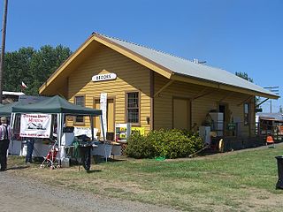
Brooks is an unincorporated community in Marion County, Oregon, United States. For statistical purposes, the United States Census Bureau has defined Brooks as a census-designated place (CDP). The census definition of the area may not precisely correspond to local understanding of the area with the same name. As of the 2010 census the population was 398. Brooks is part of the Salem Metropolitan Statistical Area.

St. Paul is a city in Marion County, Oregon, United States. It is named after the Saint Paul Mission founded by Archbishop François Norbert Blanchet, who arrived in the Oregon Country in 1838 to minister to the Catholic inhabitants of French Prairie. The population was 421 at the 2010 census. The city is part of the Salem Metropolitan Statistical Area.

Zigzag is an unincorporated community in Clackamas County, Oregon, United States. It is located within the Mount Hood Corridor, between Rhododendron and Welches on U.S. Route 26. The community is part of a local type of government called a village as one of the communities making up the Villages at Mount Hood, which stretches from the border of Sandy to Government Camp.

French Prairie is a prairie located in Marion County, Oregon, United States, in the Willamette Valley between the Willamette River and the Pudding River, north of Salem. It was named for some of the earliest settlers of that part of the Oregon Country, French Canadian/Métis people who were mostly former employees of the Hudson's Bay Company. French Prairie is also known as an early Métis settlement in the Pacific Northwest history.
Buena Vista is an unincorporated community in Polk County, Oregon, United States. It is located on the Willamette River, and is the western landing for the Buena Vista Ferry. It is approximately 6 miles (9.7 km) south-southeast of Independence.

St. Joseph's is the oldest Catholic parish in Salem, Oregon. It currently serves some 3,500 families and conducts services in English, Spanish, Vietnamese, and Latin. The parish school staff has been recognized for excellence in education as recently as 2005.
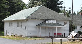
Springwater is an unincorporated rural community in Clackamas County, Oregon, United States, about three miles south of Estacada on Oregon Route 211. So-named since pioneer days, it was one of the first places on the upper Clackamas River to have a post office. Springwater post office ran from 1874–1914, with George A. Crawford as the first postmaster. The historic wooden Springwater Presbyterian Church was built c. 1890. The Springwater Grange has celebrated a Springwater Fair every year since 1923.

Saint Benedict is the name of the post office at Mount Angel Abbey in Marion County, Oregon, United States.
Waconda is a historic unincorporated community in Marion County, Oregon, United States, near the crossroads of River Road and Waconda Road. Waconda was once a station on the Oregon Electric Railway and formerly had a post office by the same name.

Blooming is an unincorporated community in Washington County, Oregon, United States near the Tualatin River, about two miles south of Cornelius. Its elevation is 190 feet. There are several plant nurseries in the area.
Shaw is an unincorporated community in Marion County, Oregon, United States, on Oregon Route 214.
Macleay is an unincorporated community in Marion County, Oregon, United States, about nine miles east of downtown Salem in the Waldo Hills near the Little Pudding River.
Cherryville is an unincorporated community and former town in Clackamas County, Oregon, United States, founded in 1884. It is located approximately 6 miles (9.7 km) east of Sandy on U.S. Route 26, near the route of the Barlow Road.
Bridge is an unincorporated community in Coos County, Oregon, United States. It is about 9 miles (14 km) east of Myrtle Point on Oregon Route 42 near the Middle Fork Coquille River.

Verboort is an unincorporated community in Washington County, Oregon, United States. It is located approximately two miles northeast of Forest Grove, one mile east of Oregon Route 47 in the Tualatin Valley. The community is part of the Forest Grove Rural Fire Protection District.

Gateway is an unincorporated community in Jefferson County, Oregon, United States. It is located about 16 miles east of Warm Springs.

Liam Cary is an American prelate of the Roman Catholic Church. He has served as bishop of the Diocese of Baker in the state of Oregon since 2012.

St. Patrick Catholic Church is a parish of the Archdiocese of Portland, Oregon in the Northwest District of Portland, Oregon, United States. The historic church building is the oldest still used as such in Portland. In 1974, it was listed on the National Register of Historic Places as St. Patrick's Roman Catholic Church and Rectory.
Rosedale is an unincorporated community in Marion County, Oregon. It is located just south of Salem in the Salem Hills. It is a part of the Salem Metropolitan Statistical Area. Rosedale post office ran from 1892 to 1901. The Rosedale area was a major prune growing region in the early 20th century but is now primarily made up of rural residential properties Vineyards and Christmas tree fields. Rosedale Elementary School located at 6974 Bates Road, Salem, Oregon was in service from 1893 until its closing in 2012. The town was located around the area of Sunnyside Road SE and Delany Road SE. It had a gas station, post office, grocery store, and a feed, seed and livery stable. The community still has a church and cemetery founded in 1896 located at 452 Hylo Rd SE.

Ira Francis Marion Butler was an American politician who served in the Oregon Territorial House of Representatives and the Oregon House of Representatives as a member of the Democratic Party. He served as Speaker of the Oregon House of Representatives from 1857 to 1858, which was the last session before Oregon's statehood. Before immigrating to Oregon, Butler served as sheriff of Warren County, Illinois, and was circuit court clerk for Stephen A. Douglas when he was an Illinois judge. After moving to Oregon in 1853, he operated a farm in Polk County and was later the county’s judge.


