Winter Island is an island connected by a causeway to Salem Neck in Salem, Massachusetts. It is about 45 acres (18 ha) in size, and is bounded by Smith Pool to the northwest, Cat Cove to the west, Salem Channel to the south and east, and Juniper Cove to the north. The island has about a dozen residences at the north end and one road, Winter Island Road. The Plummer Home for Boys sits on 18 acres (7.3 ha) of land on the northeastern shore. The balance of the island is Winter Island Marine Park. The entire island was added to the National Register of Historic Places as Winter Island Historic District and Archeological District in 1994.
The Salem Maritime National Historic Site is a National Historic Site consisting of 12 historic structures, one replica tall-ship, and about 9 acres of land along the waterfront of Salem Harbor in Salem, Massachusetts. Salem Maritime is the first National Historic Site established in the United States. It interprets the Triangle Trade during the colonial period, in cotton, rum, sugar and slaves; the actions of privateers during the American Revolution; and global maritime trade with the Far East, after independence. The National Park Service manages both the National Historic Site and a Regional Visitor Center in downtown Salem. The National Park Service (NPS) is an agency of the United States Department of the Interior.
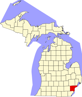
This is a list of the National Register of Historic Places listings in Wayne County, Michigan.

Spring Hill is the name of a ridge in the central part of the city of Somerville, Massachusetts, and the residential neighborhood that sits atop it. It runs northwest to southeast, roughly bounded by Highland Avenue, Somerville Avenue, Elm Street, and Willow Avenue. Summer Street runs along the hill's crest.

Long Wharf is a historic pier in Boston, Massachusetts which once extended from State Street nearly a half-mile into Boston Harbor. Today, the much-shortened wharf functions as a dock for passenger ferries and sightseeing boats.

The Bellevue Avenue Historic District is located along and around Bellevue Avenue in Newport, Rhode Island, United States. Its property is almost exclusively residential, including many of the Gilded Age mansions built by affluent summer vacationers in the city around the turn of the 20th century, including the Vanderbilt family and Astor family. Many of the homes represent pioneering work in the architectural styles of the time by major American architects.

The Ocean Drive Historic District is a historic district that covers the long street of the same name along the southern shore of Newport, Rhode Island, United States. It was designated a National Historic Landmark District in 1976, in recognition for its distinctive landscape and architecture, which is less formal and generally not as ostentatious as the grand summer properties of Bellevue Avenue.

The Salem–Auburn Streets Historic District is a residential historic district at Salem and Auburn Streets in Cambridge, Massachusetts. The district includes a collection of houses that is among the oldest in the Cambridgeport section of the city, and includes most of the houses on two blocks of these streets. The district was added to the National Register of Historic Places in 1982.

The Attleborough Falls Historic District is a predominantly residential historic district on Mt. Hope and Towne Streets in North Attleborough, Massachusetts. Located just south of the Ten Mile River, it encompasses a stylish mid-to-late 19th century residential area that developed in a previously rural area due to industrial development across the river. The district was added to the National Register of Historic Places in 2004.

Fort Lee is a historic American Revolutionary War fort in Salem, Massachusetts. The site, located at a high point next to Fort Avenue on Salem Neck, is a relatively rare fortification from that period whose remains are relatively unaltered. It is an irregular 5-pointed star fort. Although there is some documentary evidence that the Neck was fortified as early as the 17th century, the earthworks built in 1776 are the first clear evidence of the site's military use. Reportedly, the fort had a garrison of 3 officers and 100 artillerymen with 16 guns. The site, of which only overgrown earthworks and a stone magazine survive, was repaired in the 1790s, and rebuilt for the American Civil War. A state cultural resource document states that the fort has not been much modified since the Revolution, and has not been built over. It was garrisoned by the Massachusetts militia in the War of 1812, abandoned afterwards, and rebuilt with four 8-inch columbiads in the Civil War. An Army engineer drawing dated 1872 depicts the fort's five-pointed trace and the four Civil War gun positions. It was also garrisoned during the Spanish–American War.

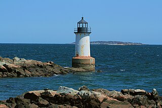
Fort Pickering is a 17th-century historic fort site on Winter Island in Salem, Massachusetts. Fort Pickering operated as a strategic coastal defense and military barracks for Salem Harbor during a variety of periods, serving as a fortification from the Anglo-Dutch Wars through World War II. Construction of the original fort began in 1643 and it saw use as a military installation into the 20th century. Fort Miller in Marblehead also defended Salem's harbor from the 1630s through the American Civil War. Fort Pickering is a First System fortification named for Colonel Timothy Pickering, born in Salem, adjutant general of the Continental Army and secretary of war in 1795. Today, the remains of the fort are open to the public as part of the Winter Island Maritime Park, operated by the City of Salem.

The Haverhill Historical Society Historic District encompasses a collection of historic buildings that have been accumulated by the Haverhill Historical Society at 240 Water Street in Haverhill, Massachusetts. The district, which was listed on the National Register of Historic Places in 2005, has at its core a Federal style farmhouse that was donated to the society in 1903. It includes about 1.5 acres (0.61 ha) of land between John Ward Avenue and the Merrimack River, on which stand four buildings; there is also an archeological site, the remains of a late 17th-century homesite, on the property.

The River Road–Cross Street Historic District is a rural agricultural historic district in Topsfield, Massachusetts. It is representative of Topsfield's development first as an agricultural community, and later as place for rural retreats. The district, which was listed on the National Register of Historic Places in 2005, is roughly bounded by River Road, Rowley Bridge Road, Cross Street, Hill Street, and Salem Road, and also includes properties facing Prospect Street and Bradstreet Lane. Much of the district was consolidated under the ownership of William Appleton Coolidge in the 20th century, and bequeathed to the Massachusetts Institute of Technology with restrictions to preserve its rural character. MIT sold the donated properties in 2000.
Beebe Homestead, also known as the Lucius Beebe House and Beebe Farm, is a historic Federal period home at 142 Main Street in Wakefield, Massachusetts, which was built during the federal era that extended from the late 18th-century into the 1820s. It is suspected to have been remodeled into the federal style from an earlier home built in circa 1727. It overlooks Lake Quannapowitt, and according to a 1989 study of historic sites in Wakefield, the house is "one of Wakefield's most imposing landmarks." The property was added to the National Register of Historic Places in 1989.

Wakefield Park Historic District is a residential historic district encompassing a portion of a late-19th/early-20th century planned development in western Wakefield, Massachusetts. The district encompasses sixteen properties on 8 acres (3.2 ha) of land out of the approximately 100 acres (40 ha) that comprised the original development. Most of the properties in the district are on Park Avenue, with a few located on immediately adjacent streets.

The Lasell Neighborhood Historic District is a historic district roughly bounded by Woodland and Studio Roads, Aspen and Seminary Avenue, and Grove Street in Newton, Massachusetts village of Auburndale, Massachusetts. The area includes high-quality late-19th and early-20th century housing built in the area, and includes buildings on the campus of Lasell University, established as the Auburndale Female Seminary in 1851. The district was listed on the National Register of Historic Places in 1986.
This is a timeline of the history of the city of Salem, Massachusetts, USA.
The Little Boar's Head Historic District encompasses an area of summer resort and beachfront properties in North Hampton, New Hampshire. Located on New Hampshire's seacoast roughly between North Hampton State Beach and Bass Beach, the district is almost entirely residential, consisting mainly of houses built as summer vacation spots in the late 19th and early 20th centuries, with associated beachfront amenities. The district was listed on the National Register of Historic Places in 1999.

Fort Hill is a 0.4 square mile neighborhood and historic district of Roxbury, in Boston, Massachusetts. The approximate boundaries of Fort Hill are Malcolm X Boulevard on the north, Washington Street on the southeast, and Columbus Avenue on the southwest.
Woodlawn, Alabama is a community in Jefferson County, Alabama, which is now a neighborhood within the city of Birmingham, Alabama. It grew as an independent community, and became the City of Woodlawn, and built a substantial City Hall building in 1908, but was annexed by Birmingham in 1910. The community area experienced a surge of growth after it was annexed.


