San Francisco, Surigao del Norte

Last updated
San Francisco
Anao-aon
Municipality of San Francisco
Ph locator surigao del norte san francisco.png
Map of Surigao del Norte with San Francisco highlighted
OpenStreetMap
San Francisco, Surigao del Norte
Philippines location map (square).svg
Red pog.svg
San Francisco
Location within the Philippines
Coordinates: 9°46′40″N125°25′23″E / 9.7778°N 125.4231°E / 9.7778; 125.4231
Country Philippines
Region Caraga
Province Surigao del Norte
District 2nd district
Named for St. Francis Xavier
Barangays 11 (see Barangays)
Government
[1]
  Type Sangguniang Bayan
   Mayor Val P. Pinat
   Vice Mayor Miguel E. Gastardo
   Representative Robert Ace S. Barbers
   Electorate 14,087 voters (2022)
Area
[2]
  Total56.72 km2 (21.90 sq mi)
Elevation
50 m (160 ft)
Highest elevation
425 m (1,394 ft)
Lowest elevation
0 m (0 ft)
Population
 (2020 census) [3]
  Total15,347
  Density270/km2 (700/sq mi)
   Households
3,734
Economy
   Income class 5th municipal income class
   Poverty incidence
32.09
% (2018) [4]
   Revenue 77.97 million (2020)
   Assets 140 million (2020)
   Expenditure 57.81 million (2020)
   Liabilities 31.54 million (2020)
Service provider
  ElectricitySurigao del Norte Electric Cooperative (SURNECO)
Time zone UTC+8 (PST)
ZIP code
8401
PSGC
IDD : area code +63(0)86
Native languages Surigaonon
Agusan
Cebuano
Tagalog

San Francisco, officially the Municipality of San Francisco (Surigaonon: Lungsod nan San Francisco; Tagalog : Bayan ng San Francisco), is a 5th class municipality in the province of Surigao del Norte, Philippines. According to the 2020 census, it has a population of 15,347 people. [3]

Contents

History

There has been many stories concerning the origin of the town but the most common is about the two lovers, Anao and Aon. Anao was a handsome, strong hunter who fell in love with Aon, the most beautiful woman and daughter of a powerful datu, who ruled the town, which was formerly a barangay. Anao and Aon vowed to be true to their love, despite the datu's objection. The datu wanted to break their love, however, he failed since the lovers were found dead near the riverbank in cold embrace. Thus, the name Anao-aon in memory of the two lovers.

Anao-aon became a pueblo after the abolition of the encomienda system in the early part of the Spanish regime with Lorenzo Tremedal, a bonafide resident of Surigao, as the Kapitan del Pueblo.

During the Spanish–American War, the town was almost reduced to ashes hence, it was reverted into a barrio until the earlier part of 1957. Through the undying efforts of Martillano Diaz, father of Ex-Board Member Macario M. Diaz, Anao-aon was emancipated and regained its status as a municipality by virtue of Executive Order No. 249 on May 24, 1957, during the time of President Carlos P. Garcia. Macario M, Diaz was given the title of Father of the Municipality of Anao-aon. On August 15, 1957, the municipality was inaugurated.

During the time of Mayor Francisco Delani, through House Bill No. 1768, approved May 20, 1971 by the House of the Senate, its unique and indigenous name Anao-aon was changed into San Francisco in honor of the Patron Saint, Saint Francis Xavier only to find out that it was creating confusion because there are many municipalities in the Philippines already named after San Francisco, but then it's too late for its politician authors and supporters to make the move to revert into its original name of Anao-aon.

Geography

Barangays

San Francisco is politically subdivided into 11 barangays. Each barangay consists of puroks while some have sitios.

Climate

Climate data for San Francisco, Surigao del Norte
MonthJanFebMarAprMayJunJulAugSepOctNovDecYear
Average high °C (°F)27
(81)
27
(81)
28
(82)
29
(84)
29
(84)
29
(84)
29
(84)
30
(86)
30
(86)
29
(84)
28
(82)
28
(82)
29
(83)
Average low °C (°F)22
(72)
22
(72)
22
(72)
23
(73)
23
(73)
23
(73)
23
(73)
23
(73)
23
(73)
23
(73)
23
(73)
23
(73)
23
(73)
Average precipitation mm (inches)152
(6.0)
116
(4.6)
90
(3.5)
68
(2.7)
88
(3.5)
96
(3.8)
78
(3.1)
73
(2.9)
70
(2.8)
96
(3.8)
125
(4.9)
132
(5.2)
1,184
(46.8)
Average rainy days20.817.718.517.220.822.522.522.722.023.722.519.9250.8
Source: Meteoblue [5]

Demographics

Population census of San Francisco
YearPop.±% p.a.
1903 1,481    
1960 6,272+2.56%
1970 6,486+0.34%
1975 7,572+3.15%
1980 8,674+2.75%
1990 9,445+0.86%
1995 10,005+1.09%
2000 11,521+3.07%
2007 12,449+1.07%
2010 13,335+2.53%
2015 14,552+1.68%
2020 15,347+1.05%
Source: Philippine Statistics Authority [6] [7] [8] [9]

Economy

Related Research Articles

<span class="mw-page-title-main">Mainit</span> Municipality in Surigao del Norte, Philippines

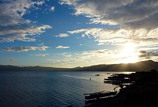
Mainit, officially the Municipality of Mainit, is a 4th class municipality in the province of Surigao del Norte, Philippines. According to the 2020 census, it has a population of 28,019 people.

<span class="mw-page-title-main">Burgos, Surigao del Norte</span> Municipality in Surigao del Norte, Philippines

Burgos, officially the Municipality of Burgos, is a 6th class municipality in the province of Surigao del Norte, Philippines. According to the 2020 census, it has a population of 4,185 people.

<span class="mw-page-title-main">Del Carmen, Surigao del Norte</span> Municipality in Surigao del Norte, Philippines

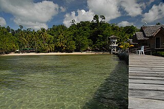
Del Carmen, officially the Municipality of Del Carmen, is a 5th class municipality in the province of Surigao del Norte, Philippines. According to the 2015 census, it has a population of 18,392 people. The municipality was formerly called Numancia until 1966 when it was changed to its present name. It is located on Siargao Island and home to Sayak Airport, the island's main airport.

<span class="mw-page-title-main">Gigaquit</span> Municipality in Surigao del Norte, Philippines

Gigaquit, officially the Municipality of Gigaquit, is a 4th class municipality in the province of Surigao del Norte, Philippines. According to the 2020 census, it has a population of 21,849 people.

<span class="mw-page-title-main">Malimono</span> Municipality in Surigao del Norte, Philippines

Malimono, officially the Municipality of Malimono, is a 5th class municipality in the province of Surigao del Norte, Philippines. According to the 2020 census, it has a population of 18,852 people.

<span class="mw-page-title-main">Pilar, Surigao del Norte</span> Municipality in Surigao del Norte, Philippines

Pilar, officially the Municipality of Pilar, is a 5th class municipality in the province of Surigao del Norte, Philippines. According to the 2020 census, it has a population of 10,374 people.

<span class="mw-page-title-main">San Benito, Surigao del Norte</span> Municipality in Surigao del Norte, Philippines

San Benito, officially the Municipality of San Benito, is a 6th class municipality in the province of Surigao del Norte, Philippines. According to the 2020 census, it has a population of 5,663 people.

<span class="mw-page-title-main">San Isidro, Surigao del Norte</span> Municipality in Surigao del Norte, Philippines

San Isidro, officially the Municipality of San Isidro, is a 5th class municipality in the province of Surigao del Norte, Philippines. According to the 2020 census, it has a population of 8,519 people.

<span class="mw-page-title-main">Sison, Surigao del Norte</span> Municipality in Surigao del Norte, Philippines

Sison, officially the Municipality of Sison, is a 5th class municipality in the province of Surigao del Norte, Philippines. According to the 2020 census, it has a population of 14,290 people.

<span class="mw-page-title-main">Socorro, Surigao del Norte</span> Municipality in Surigao del Norte, Philippines

Socorro, officially the Municipality of Socorro, is a 4th class municipality in the province of Surigao del Norte, Philippines. According to the 2020 census, it has a population of 25,942 people.

<span class="mw-page-title-main">Tubajon</span> Municipality in Dinagat Islands, Philippines

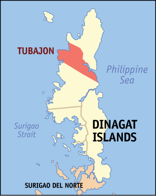
Tubajon, officially the Municipality of Tubajon, is a 5th class municipality in the province of Dinagat Islands, Philippines. According to the 2020 census, it has a population of 8,119 people.

<span class="mw-page-title-main">Barobo</span> Municipality in Surigao del Sur, Philippines

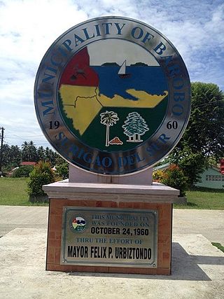
Barobo, officially the Municipality of Barobo, is a 3rd class municipality in the province of Surigao del Sur, Philippines. According to the 2020 census, it has a population of 53,146 people.

<span class="mw-page-title-main">Bayabas, Surigao del Sur</span> Municipality in Surigao del Sur, Philippines

Bayabas, officially the Municipality of Bayabas, is a 5th class municipality in the province of Surigao del Sur, Philippines. According to the 2020 census, it has a population of 8,979 people.

<span class="mw-page-title-main">Carmen, Surigao del Sur</span> Municipality in Surigao del Sur, Philippines

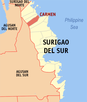
Carmen, officially the Municipality of Carmen, is a 5th class municipality in the province of Surigao del Sur, Philippines. According to the 2020 census, it has a population of 11,720 people.

<span class="mw-page-title-main">Lianga</span> Municipality in Surigao del Sur, Philippines

Lianga, officially the Municipality of Lianga, is a 4th class municipality in the province of Surigao del Sur, Philippines. According to the 2020 census, it has a population of 33,869 people.

<span class="mw-page-title-main">Lingig</span> Municipality in Surigao del Sur, Philippines

Lingig, officially the Municipality of Lingig, is a 2nd class municipality in the province of Surigao del Sur, Philippines. According to the 2020 census, it had a population of 35,142 people.

<span class="mw-page-title-main">Marihatag</span> Municipality in Surigao del Sur, Philippines

Marihatag, officially the Municipality of Marihatag ;, is a 3rd class municipality in the province of Surigao del Sur, Philippines. According to the 2020 census, it has a population of 19,441 people.

<span class="mw-page-title-main">San Agustin, Surigao del Sur</span> Municipality in Surigao del Sur, Philippines

San Agustin, officially the Municipality of San Agustin, is a 4th class municipality in the province of Surigao del Sur, Philippines. According to the 2020 census, it has a population of 22,855 people.

<span class="mw-page-title-main">San Miguel, Surigao del Sur</span> Municipality in Surigao del Sur, Philippines

San Miguel, officially the Municipality of San Miguel, is a 1st class municipality in the province of Surigao del Sur, Philippines. According to the 2020 census, it has a population of 41,809 people.

<span class="mw-page-title-main">Tagbina</span> Municipality in Surigao del Sur, Philippines

Tagbina, officially the Municipality of Tagbina, is a 2nd class municipality in the province of Surigao del Sur, Philippines. According to the 2020 census, it has a population of 41,051 people.

References

  1. Municipality of San Francisco | (DILG)
  2. "2015 Census of Population, Report No. 3 – Population, Land Area, and Population Density" (PDF). Philippine Statistics Authority. Quezon City, Philippines. August 2016. ISSN   0117-1453. Archived (PDF) from the original on May 25, 2021. Retrieved July 16, 2021.
  3. 1 2 Census of Population (2020). "Caraga". Total Population by Province, City, Municipality and Barangay. Philippine Statistics Authority . Retrieved 8 July 2021.
  4. "PSA Releases the 2018 Municipal and City Level Poverty Estimates". Philippine Statistics Authority. 15 December 2021. Retrieved 22 January 2022.
  5. "San Francisco: Average Temperatures and Rainfall". Meteoblue. Retrieved 20 November 2019.
  6. Census of Population (2015). "Caraga". Total Population by Province, City, Municipality and Barangay. Philippine Statistics Authority . Retrieved 20 June 2016.
  7. Census of Population and Housing (2010). "Caraga". Total Population by Province, City, Municipality and Barangay. National Statistics Office . Retrieved 29 June 2016.
  8. Censuses of Population (1903–2007). "Caraga". Table 1. Population Enumerated in Various Censuses by Province/Highly Urbanized City: 1903 to 2007. National Statistics Office.
  9. "Province of Surigao del Norte". Municipality Population Data. Local Water Utilities Administration Research Division. Retrieved 17 December 2016.
  10. "Poverty incidence (PI):". Philippine Statistics Authority. Retrieved December 28, 2020.
  11. "Estimation of Local Poverty in the Philippines" (PDF). Philippine Statistics Authority. 29 November 2005.
  12. "2003 City and Municipal Level Poverty Estimates" (PDF). Philippine Statistics Authority. 23 March 2009.
  13. "City and Municipal Level Poverty Estimates; 2006 and 2009" (PDF). Philippine Statistics Authority. 3 August 2012.
  14. "2012 Municipal and City Level Poverty Estimates" (PDF). Philippine Statistics Authority. 31 May 2016.
  15. "Municipal and City Level Small Area Poverty Estimates; 2009, 2012 and 2015". Philippine Statistics Authority. 10 July 2019.
  16. "PSA Releases the 2018 Municipal and City Level Poverty Estimates". Philippine Statistics Authority. 15 December 2021. Retrieved 22 January 2022.