
Azusa is a city in the San Gabriel Valley region of Los Angeles County, California, United States at the foot of the San Gabriel Mountains located 20 miles east of downtown Los Angeles.

The Los Angeles County Metropolitan Transportation Authority (LACMTA), commonly branded as Metro, LA Metro, and L.A. Metro, is the state agency that plans, operates, and coordinates funding for most of the transportation system in Los Angeles County, California The agency directly operates a large transit system that includes bus, light rail, heavy rail (subway), and bus rapid transit services; and provides funding for transit it does not operate, including Metrolink commuter rail, municipal bus operators and paratransit services. Metro also provides funding and directs planning for railroad and highway projects within Los Angeles County. In 2021, the system had a total ridership of 227,718,700 and had a ridership of 788,800 per weekday as of the third quarter of 2022. It is the single largest transit agency within the county as well.
The Santa Monica Mountains Conservancy is an agency of the state of California in the United States founded in 1980 and dedicated to the acquisition of land for preservation as open space, for wildlife and California native plants habitat Nature Preserves, and for public recreation activities.

The Santa Clara River is an 83 mi (134 km) long river in Ventura and Los Angeles counties in Southern California. It drains parts of four ranges in the Transverse Ranges System north and northwest of Los Angeles, then flows west onto the Oxnard Plain and into the Santa Barbara Channel of the Pacific Ocean.

The Santa Ana River is the largest river entirely within Southern California in the United States. It rises in the San Bernardino Mountains and flows for most of its length through San Bernardino and Riverside Counties, before cutting through the northern Santa Ana Mountains via Santa Ana Canyon and flowing southwest through urban Orange County to drain into the Pacific Ocean. The Santa Ana River is 96 miles (154 km) long, and its drainage basin is 2,650 square miles (6,900 km2) in size.

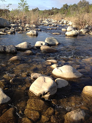
The San Gabriel River is a mostly urban waterway flowing 58 miles (93 km) southward through Los Angeles and Orange Counties, California in the United States. It is the central of three major rivers draining the Greater Los Angeles Area, the others being the Los Angeles River and Santa Ana River. The river's watershed stretches from the rugged San Gabriel Mountains to the heavily developed San Gabriel Valley and a significant part of the Los Angeles coastal plain, emptying into the Pacific Ocean between the cities of Long Beach and Seal Beach.

The Arroyo Seco, meaning "dry stream" in Spanish, is a 24.9-mile-long (40.1 km) seasonal river, canyon, watershed, and cultural area in Los Angeles County, California. The area was explored by Gaspar de Portolà who named the stream Arroyo Seco as this canyon had the least water of any he had seen. During this exploration he met the Chief Hahamog-na (Hahamonga) of the Tongva Indians.

Ballona Creek is an 8.5-mile (13.7 km) channelized stream in southwestern Los Angeles County, California, United States, that was once a "year-round river lined with sycamores and willows" with the Tongva village of Guashna located at the mouth of the creek. Ballona Creek and neighboring Ballona Wetlands remain a prime bird-watching spot for waterfowl, shorebirds, warblers, and birds of prey.

The California State Coastal Conservancy is a non-regulatory state agency in California established in 1976 to enhance coastal resources and public access to the coast. The CSCC is a department of the California Natural Resources Agency. The agency's work is conducted along the entirety of the California coast, including the interior San Francisco Bay and is responsible for the planning and coordination of federal land sales to acquire into state land as well as award grant funding for improvement projects. The Board of Directors for the agency is made up of seven members who are appointed by the Governor of California and approved by the California Legislature, members of the California State Assembly and California State Senate engage and provide oversight within their legislative capacity.

The San Gabriel River Trail is a 28-mile (45 km) bike path along the San Gabriel River through El Dorado Regional Park and onto street bike trails near the Alamitos Bay Marina in Los Angeles County, California. The South end is Seal Beach. The northern segment begins near Whittier Narrows Recreation Area.
The Ventura River, in western Ventura County in southern California, United States, flows 16.2 miles (26.1 km) from its headwaters to the Pacific Ocean. The smallest of the three major rivers in Ventura County, it flows through the steeply sloped, narrow Ventura Valley, with its final 0.7 miles (1.1 km) through the broader Ventura River estuary, which extends from where it crosses under a 101 Freeway bridge through to the Pacific Ocean.
The Council for Watershed Health (CWH) is a nonprofit environmental organization in the U.S. state of California. It was founded in 1996 by Dorothy Green to preserve, restore, and enhance the Los Angeles and San Gabriel River watersheds. To accomplish this, it has brought together representatives from the regional water agencies, as well as government regulatory agencies ; community and environmental citizen groups; and businesses in the Los Angeles Basin watershed.

San Diego Creek is a 16-mile (26 km) urban waterway flowing into Upper Newport Bay in Orange County, California in the United States. Its watershed covers 112.2 square miles (291 km2) in parts of eight cities, including Irvine, Tustin, and Costa Mesa. From its headwaters in Laguna Woods the creek flows northwest to its confluence with Peters Canyon Wash, where it turns abruptly southwest towards the bay. Most of the creek has been converted to a concrete flood control channel, but it also provides important aquatic and riparian habitat along its course and its tidal estuary.

The Southern California Public Power Authority (SCPPA) is a joint powers authority, or a collective of 10 municipal utilities and one irrigation district in Southern California, United States.

Coyote Creek is a principal tributary of the San Gabriel River in northwest Orange County, southeast Los Angeles County, and southwest Riverside County, California. It drains a land area of roughly 41.3 square miles (107 km2) covering eight major cities, including Brea, Buena Park, Fullerton, Hawaiian Gardens, La Habra, Lakewood, La Palma, and Long Beach. Some major tributaries of the creek in the highly urbanized watershed include Brea Creek, Fullerton Creek, and Carbon Creek. The mostly flat creek basin is separated by a series of low mountains, and is bounded by several small mountain ranges, including the Chino Hills, Puente Hills, and West Coyote Hills.

San Mateo Creek is a stream in Southern California in the United States, whose watershed mostly straddles the border of Orange and San Diego Counties. It is about 22 miles (35 km) long, flowing in a generally southwesterly direction. Draining a broad valley bounded by the Santa Ana Mountains and Santa Margarita Mountains, San Mateo Creek is notable for being one of the last unchannelized streams in Southern California.
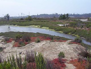
Los Cerritos Wetlands is located in both Los Angeles County and Orange County in the cities of Long Beach, California, and Seal Beach, California. The San Gabriel River, historically and currently flows through the Los Cerritos Wetlands Complex.
The Gardena Willows Wetland Preserve occupies 13.6 acres (55,000 m2) of land owned by the City of Gardena, in Los Angeles County, California. The preserve is the last intact remnant of the former Dominguez Slough, an important vernal marsh and riparian forest with riparian zones that once covered as much as 400 acres (1,600,000 m2) of this area, known as the South Bay region. The preserve has 9.4 acres (38,000 m2) of wetland and 4.2 acres (17,000 m2) of upland. The wetlands have a natural depression where water remains for such a significant time that plants and animals not adapted to water and saturated soils cannot survive. The upland, which remains dry outside of the rainy season, supports plants which thrive with these drier conditions. The slough is a part of the Dominguez Watershed, 96% of which is now covered with concrete and man-made structures. Located on the traditional lands of the Tongva, it is believed that these indigenous people were able to commute by canoe around much of the area. Tongva villages were located throughout much of what is now Los Angeles and Orange Counties as well as three southern Channel Islands as distant as 60 miles (97 km) from the coast of Los Angeles County.

Cottonwood Creek is a major stream and tributary of the Sacramento River in Northern California. About 68 miles (109 km) long measured to its uppermost tributaries, the creek drains a large rural area bounded by the crest of the Coast Ranges, traversing the northwestern Sacramento Valley before emptying into the Sacramento River near the town of Cottonwood. For its entire length, it defines the boundary of Shasta and Tehama counties. Because Cottonwood Creek is the largest undammed tributary of the Sacramento River, it is known for its Chinook salmon and steelhead runs.

Anaheim Bay is an extensive harbor and wetland complex in Orange County, California in the United States. The bay is located on the Pacific Ocean coast of northwestern Orange County next to Seal Beach and is split into several distinct but interconnected parts. The term "Anaheim Bay" generally refers to the deep-water Navy harbor at the bay entrance. Further southeast are the Huntington Harbor, which serves small private vessels, and the Bolsa Bay, a salt-water estuary. Bordering the bay are hundreds of acres of salt marshes, some of the largest remaining such habitats in Southern California.