San Policarpo, Eastern Samar

Last updated
San Policarpo
Municipality of San Policarpo
Flag of San Policarpo, Eastern Samar.png
Ph locator eastern samar san policarpo.png
Map of Eastern Samar with San Policarpo highlighted
OpenStreetMap
San Policarpo, Eastern Samar
Philippines location map (square).svg
Red pog.svg
San Policarpo
Location within the Philippines
Coordinates: 12°10′45″N125°30′26″E / 12.1791°N 125.5072°E / 12.1791; 125.5072
Country Philippines
Region Eastern Visayas
Province Eastern Samar
District Lone district
FoundedJune 16, 1948
InauguratedFebruary 5, 1949
Barangays 17 (see Barangays)
Government
[1]
  Type Sangguniang Bayan
   Mayor Conrado U. Nicart III
   Vice Mayor Thelma U. Nicart
   Representative Maria Fe R. Abunda
  Councilors
List
   Electorate 13,448 voters (2022)
Area
[2]
  Total78 km2 (30 sq mi)
Elevation
6.0 m (19.7 ft)
Highest elevation
63 m (207 ft)
Lowest elevation
0 m (0 ft)
Population
 (2020 census) [3]
  Total15,365
  Density200/km2 (510/sq mi)
   Households
3,602
Economy
   Income class 5th municipal income class
   Poverty incidence
55.81
% (2018) [4]
   Revenue 87.85 million (2020)
   Assets 213.1 million (2020)
   Expenditure 69.21 million (2020)
   Liabilities 89.2 million (2020)
Service provider
  ElectricityEastern Samar Electric Cooperative (ESAMELCO)
Time zone UTC+8 (PST)
ZIP code
6821
PSGC
IDD : area code +63(0)55
Native languages Waray
Tagalog
Website www.sanpolicarpo-esamar.gov.ph

San Policarpo, officially the Municipality of San Policarpo (Waray : Bungto han San Policarpo; Tagalog : Bayan ng San Policarpo), is a 5th class municipality in the province of Eastern Samar, Philippines. According to the 2020 census, it has a population of 15,365 people. [3]

Contents

In the north-west, it is bounded by Arteche, in the north-east by the vast Pacific Ocean and in the south by Oras.

History

San Policarpo was established as a barrio in 1837. The Municipality of San Policarpo was created from the barrios of San Policarpo, Bahay, Alugan, Pangpang, Japunan, Tabo, Binogawan and Cajagwayan of the municipality of Oras, then in the province of Samar, by virtue of Republic Act No. 281 signed on June 16, 1948 and inaugurated on February 5, 1949. [5] In 1952, the barrio of Santa Monica was transferred from Oras to San Policarpo. On June 19, 1965, the municipality was annexed to the newly-established province of Eastern Samar through a plebiscite and the sitios of Santa Cruz, Tan-awan, Bangon, Guin-osokan, Barras, Lipata and Libas were converted into barrios. [6] [7]

The town was formerly named "Bunga", derived from the plant called bunga which was very abundant in the present site of the town. "Bunga" means fruit, thus the name indicates the fruit of the toils of its founders.

Geography

Barangays

San Policarpo is politically subdivided into 17 barangays. [8] Each barangay consists of puroks and some have sitios.

  • Alugan
  • Bahay
  • Bangon
  • Baras (Lipata)
  • Binogawan
  • Cajagwayan
  • Japunan
  • Natividad
  • Pangpang
  • Barangay No. 1 (Poblacion)
  • Barangay No. 2 (Poblacion)
  • Barangay No. 3 (Poblacion)
  • Barangay No. 4 (Poblacion)
  • Barangay No. 5 (Poblacion)
  • Santa Cruz
  • Tabo
  • Tan-awan

Climate

Climate data for San Policarpo, Eastern Samar
MonthJanFebMarAprMayJunJulAugSepOctNovDecYear
Average high °C (°F)27
(81)
27
(81)
28
(82)
29
(84)
30
(86)
30
(86)
30
(86)
30
(86)
29
(84)
29
(84)
28
(82)
27
(81)
29
(84)
Average low °C (°F)23
(73)
22
(72)
22
(72)
23
(73)
24
(75)
24
(75)
24
(75)
24
(75)
24
(75)
24
(75)
24
(75)
23
(73)
23
(74)
Average precipitation mm (inches)105
(4.1)
67
(2.6)
65
(2.6)
53
(2.1)
86
(3.4)
129
(5.1)
135
(5.3)
113
(4.4)
131
(5.2)
163
(6.4)
167
(6.6)
162
(6.4)
1,376
(54.2)
Average rainy days17.613.215.514.919.624.326.625.424.925.422.920.9251.2
Source: Meteoblue [9]

Demographics

Population census of San Policarpo
YearPop.±% p.a.
1948 4,779    
1960 8,051+4.44%
1970 9,140+1.28%
1975 9,280+0.31%
1980 12,258+5.72%
1990 9,970−2.05%
1995 11,565+2.82%
2000 12,403+1.51%
2007 13,689+1.37%
2010 13,836+0.39%
2015 14,687+1.14%
2020 15,365+0.89%
Source: Philippine Statistics Authority [10] [11] [12] [13]

The population of San Policarpo, Eastern Samar, in the 2020 census was 15,365 people, [3] with a density of 200 inhabitants per square kilometre or 520 inhabitants per square mile.

Economy

The local economy of San Policarpo, one of the country's poorest towns, is dependent on fishing and farming. [21]

Related Research Articles

<span class="mw-page-title-main">Balangiga</span> Municipality in Eastern Samar, Philippines

Balangiga, officially the Municipality of Balangiga, is a 4th class municipality in the province of Eastern Samar, Philippines. According to the 2020 census, it has a population of 14,341 people.

<span class="mw-page-title-main">Basey</span> Municipality in Samar, Philippines

Basey, officially the Municipality of Basey, is a 1st class municipality in the province of Samar, Philippines. According to the 2020 census, it has a population of 56,685 people.

<span class="mw-page-title-main">Jiabong</span> Municipality in Samar, Philippines

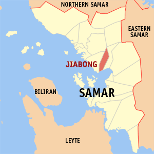
Jiabong, officially the Municipality of Jiabong, is a 5th class municipality in the province of Samar, Philippines. According to the 2020 census, it has a population of 19,205 people.

<span class="mw-page-title-main">Marabut, Samar</span> Municipality in Samar, Philippines

Marabut, officially the Municipality of Marabut, is a 5th class municipality in the province of Samar, Philippines. According to the 2020 census, it has a population of 17,842 people.

<span class="mw-page-title-main">Pagsanghan</span> Municipality in Samar, Philippines

Pagsanghan, officially the Municipality of Pagsanghan, is a 5th class municipality in the province of Samar, Philippines. According to the 2020 census, it has a population of 7,959 people.

<span class="mw-page-title-main">San Sebastian, Samar</span> Municipality in Samar, Philippines

San Sebastian, officially the Municipality of San Sebastian, is a 6th class municipality in the province of Samar, Philippines. According to the 2020 census, it has a population of 8,704 people.

<span class="mw-page-title-main">Talalora</span> Municipality in Samar, Philippines

Talalora, officially the Municipality of Talalora, is a 6th class municipality in the province of Samar, Philippines. According to the 2020 census, it has a population of 7,856 people.

<span class="mw-page-title-main">Tarangnan</span> Municipality in Samar, Philippines

Tarangnan, officially the Municipality of Tarangnan, is a 4th class municipality in the province of Samar, Philippines. According to the 2020 census, it has a population of 25,713 people.

<span class="mw-page-title-main">Gamay, Northern Samar</span> Municipality in Northern Samar, Philippines

Gamay, officially the Municipality of Gamay, is a 4th class municipality in the province of Northern Samar, Philippines. According to the 2020 census, it has a population of 23,367 people.

<span class="mw-page-title-main">Lavezares</span> Municipality in Northern Samar, Philippines

Lavezares, officially the Municipality of Lavezares, is a 4th class municipality in the province of Northern Samar, Philippines. According to the 2020 census, it has a population of 29,390 people.

<span class="mw-page-title-main">San Roque, Northern Samar</span> Municipality in Northern Samar, Philippines

San Roque, officially the Municipality of San Roque, is a 4th class municipality in the province of Northern Samar, Philippines. According to the 2020 census, it has a population of 29,882 people.

<span class="mw-page-title-main">Arteche</span> Municipality in Eastern Samar, Philippines

Arteche, officially the Municipality of Arteche, is a 3rd class municipality in the province of Eastern Samar, Philippines. According to the 2020 census, it has a population of 16,360 people.

<span class="mw-page-title-main">Can-avid</span> Municipality in Eastern Samar, Philippines

Can-avid, officially the Municipality of Can-avid, is a 4th class municipality in the province of Eastern Samar, Philippines. According to the 2020 census, it has a population of 21,682 people.

<span class="mw-page-title-main">Dolores, Eastern Samar</span> Municipality in Eastern Samar, Philippines

Dolores, officially the Municipality of Dolores, is a 3rd class municipality in the province of Eastern Samar, Philippines. According to the 2020 census, it has a population of 44,626 people.

<span class="mw-page-title-main">General MacArthur, Eastern Samar</span> Municipality in Eastern Samar, Philippines

General MacArthur, officially the Municipality of General MacArthur, is a 5th class municipality in the province of Eastern Samar, Philippines. According to the 2020 census, it has a population of 14,411 people.

<span class="mw-page-title-main">Maydolong</span> Municipality in Eastern Samar, Philippines

Maydolong, officially the Municipality of Maydolong, is a 4th class municipality in the province of Eastern Samar, Philippines. According to the 2020 census, it has a population of 15,314 people.

<span class="mw-page-title-main">Mercedes, Eastern Samar</span> Municipality in Eastern Samar, Philippines

Mercedes, officially the Municipality of Mercedes, is a 5th class municipality in the province of Eastern Samar, Philippines. According to the 2020 census, it has a population of 6,112 people.

<span class="mw-page-title-main">Oras, Eastern Samar</span> Municipality in Eastern Visayas, Philippines

Oras, officially the Municipality of Oras, is a 3rd class municipality in the province of Eastern Samar, Philippines. According to the 2020 census, it has a population of 37,451 people.

<span class="mw-page-title-main">Salcedo, Eastern Samar</span> Municipality in Eastern Samar, Philippines

Salcedo, officially the Municipality of Salcedo, is a 5th class municipality in the province of Eastern Samar, Philippines. According to the 2020 census, it has a population of 22,136 people.

<span class="mw-page-title-main">Catbalogan</span> Capital of Samar, Philippines

Catbalogan, officially the City of Catbalogan, is a 5th class component city and capital of the province of Samar, Philippines. According to the 2020 census, it has a population of 106,440 people.

References

  1. Municipality of San Policarpo | (DILG)
  2. "2015 Census of Population, Report No. 3 – Population, Land Area, and Population Density" (PDF). Philippine Statistics Authority. Quezon City, Philippines. August 2016. ISSN   0117-1453. Archived (PDF) from the original on May 25, 2021. Retrieved July 16, 2021.
  3. 1 2 3 Census of Population (2020). "Region VIII (Eastern Visayas)". Total Population by Province, City, Municipality and Barangay. Philippine Statistics Authority . Retrieved 8 July 2021.
  4. "PSA Releases the 2018 Municipal and City Level Poverty Estimates". Philippine Statistics Authority. 15 December 2021. Retrieved 22 January 2022.
  5. Republic Act No. 281 (16 June 1948). An Act Creating the Municipality of San Policarpo in the Province of Samar . Retrieved June 13, 2023.
  6. Republic Act No. 4221 (19 June 1965). An Act Creating the Provinces of Northern Samar, Eastern Samar and Western Samar . Retrieved December 19, 2015.
  7. Republic Act No. 281 (19 June 1965). An Act Creating Barrios in the Municipality of San Policarpo, Province of Samar . Retrieved June 13, 2023.
  8. "Province: Eastern Samar". PSGC Interactive. Quezon City, Philippines: Philippine Statistics Authority . Retrieved 12 November 2016.
  9. "San Policarpo, Eastern Samar: Average Temperatures and Rainfall". Meteoblue. Retrieved 31 December 2018.
  10. Census of Population (2015). "Region VIII (Eastern Visayas)". Total Population by Province, City, Municipality and Barangay. Philippine Statistics Authority . Retrieved 20 June 2016.
  11. Census of Population and Housing (2010). "Region VIII (Eastern Visayas)". Total Population by Province, City, Municipality and Barangay. National Statistics Office . Retrieved 29 June 2016.
  12. Censuses of Population (1903–2007). "Region VIII (Eastern Visayas)". Table 1. Population Enumerated in Various Censuses by Province/Highly Urbanized City: 1903 to 2007. National Statistics Office.
  13. "Province of Eastern Samar". Municipality Population Data. Local Water Utilities Administration Research Division. Retrieved 17 December 2016.
  14. "Poverty incidence (PI):". Philippine Statistics Authority. Retrieved December 28, 2020.
  15. "Estimation of Local Poverty in the Philippines" (PDF). Philippine Statistics Authority. 29 November 2005.
  16. "2003 City and Municipal Level Poverty Estimates" (PDF). Philippine Statistics Authority. 23 March 2009.
  17. "City and Municipal Level Poverty Estimates; 2006 and 2009" (PDF). Philippine Statistics Authority. 3 August 2012.
  18. "2012 Municipal and City Level Poverty Estimates" (PDF). Philippine Statistics Authority. 31 May 2016.
  19. "Municipal and City Level Small Area Poverty Estimates; 2009, 2012 and 2015". Philippine Statistics Authority. 10 July 2019.
  20. "PSA Releases the 2018 Municipal and City Level Poverty Estimates". Philippine Statistics Authority. 15 December 2021. Retrieved 22 January 2022.
  21. Ricky Bautista (July 28, 2014). "Eastern Samar town has 2 mayors". The Philippine Star. Retrieved 28 July 2016.