San Remigio, Antique

Last updated
San Remigio
Municipality of San Remigio
Brgy Aningalan, San Remegio, Antique.JPG
Aningalan Highlands in San Remigio
Flag of San Remigio, Antique.png
Ph locator antique san remigio.png
Map of Antique with San Remigio highlighted
OpenStreetMap
San Remigio, Antique
Philippines location map (square).svg
Red pog.svg
San Remigio
Location within the Philippines
Coordinates: 10°49′59″N122°05′15″E / 10.833092°N 122.087506°E / 10.833092; 122.087506
Country Philippines
Region Western Visayas
Province Antique
District Lone district
Founded July 1, 1864
Named for Saint Remigius
Barangays 45 (see Barangays)
Government
[1]
  Type Sangguniang Bayan
   Mayor Margarito C. Mission Jr.
   Vice Mayor Eduardson G. Petinglay
   Representative Antonio Agapito B. Legarda Jr.
   Municipal Council
Members
   Electorate 22,808 voters (2022)
Area
[2]
  Total406.98 km2 (157.14 sq mi)
Elevation
407 m (1,335 ft)
Highest elevation
(Mount Igdalig)
1,377 m (4,518 ft)
Lowest elevation
60 m (200 ft)
Population
 (2020 census) [3]
  Total34,045
  Density84/km2 (220/sq mi)
   Households
7,911
Economy
   Income class 3rd municipal income class
   Poverty incidence
33.09
% (2018) [4]
   Revenue 189 million (2020)
   Assets 404.6 million (2020)
   Expenditure 127.7 million (2020)
   Liabilities 230.3 million (2020)
Service provider
  ElectricityAntique Electric Cooperative (ANTECO)
Time zone UTC+8 (PST)
ZIP code
5714
PSGC
IDD : area code +63(0)36
Native languages Karay-a
Hiligaynon
Tagalog

San Remigio, officially the Municipality of San Remigio (Kinaray-a : Banwa kang San Remigio; Hiligaynon : Banwa sang San Remigio; Tagalog : Bayan ng San Remigio), is a 3rd class municipality in the province of Antique, Philippines. According to the 2020 census, it has a population of 34,045 people. [3] Making it 10th most populous municipality in the province of Antique and the largest municipality in terms of land area, with a total area of 406.98 square kilometers.

Contents

History

On the morning of September 12, 1988, Mayor Gideon Cabigunda was on the road to meet with former members of the communist rebel group the New People's Army (NPA) who have surrendered when he and four of his security aides were assassinated by other NPA rebels. [5] Romilo Sequrra, a 19-year-old rebel, later surrendered to authorities from the Philippine Air Force and admitted to being part of the group that committed the assassination. [6]

Geography

San Remigio is located at 10°49′59″N122°05′15″E / 10.833092°N 122.087506°E / 10.833092; 122.087506 . It is 21 kilometres (13 mi) north-east from the provincial capital, San Jose de Buenavista.

According to the Philippine Statistics Authority, the municipality has a land area of 406.98 square kilometres (157.14 sq mi) [7] constituting

Almost 70% of its land area are mountainous and the remaining 30% comprise the flat lowland and rolling hills.

Agriculture occupies 47.815 square kilometres (18.461 sq mi) of land. Of this, 44.37 square kilometres (17.13 sq mi) is for food crops, 1.035 square kilometres (0.400 sq mi) is for permanent crops, and 2.41 square kilometres (0.93 sq mi) for commercial crops.

Climate

Climate data for San Remigio, Antique
MonthJanFebMarAprMayJunJulAugSepOctNovDecYear
Average high °C (°F)30
(86)
31
(88)
32
(90)
33
(91)
32
(90)
30
(86)
29
(84)
28
(82)
28
(82)
29
(84)
29
(84)
30
(86)
30
(86)
Average low °C (°F)21
(70)
21
(70)
21
(70)
23
(73)
24
(75)
24
(75)
24
(75)
24
(75)
24
(75)
23
(73)
22
(72)
21
(70)
23
(73)
Average precipitation mm (inches)19
(0.7)
17
(0.7)
26
(1.0)
37
(1.5)
119
(4.7)
191
(7.5)
258
(10.2)
260
(10.2)
248
(9.8)
196
(7.7)
97
(3.8)
39
(1.5)
1,507
(59.3)
Average rainy days7.25.28.311.922.326.528.328.227.326.418.711.8222.1
Source: Meteoblue [8]

Barangays

San Remigio is politically subdivided into 45 barangays. [9] Each barangay consists of puroks and some have sitios.

PSGC Barangay Population ±% p.a.
2020 [3] 2010 [10]
060614001 Agricula 1.6% 547 494 1.02%
060614002 Alegria 1.3% 431 422 0.21%
060614003 Aningalan 1.8% 607 511 1.74%
060614004 Atabay 0.5% 178 175 0.17%
060614005 Bagumbayan 1.8% 612 484 2.37%
060614006 Baladjay 1.9% 660 1,100 −4.98%
060614007 Banbanan 0.8% 269 265 0.15%
060614008 Barangbang 4.0% 1,362 1,150 1.71%
060614009 Bawang 1.4% 470 441 0.64%
060614010 Bugo 4.7% 1,600 1,586 0.09%
060614011 Bulan-bulan 1.7% 565 541 0.43%
060614012 Cabiawan 1.5% 502 449 1.12%
060614013 Cabunga-an 1.3% 457 450 0.15%
060614014 Cadolonan 2.8% 954 883 0.78%
060614016 Carawisan I 1.6% 556 514 0.79%
060614017 Carawisan II 1.7% 567 514 0.99%
060614018 Carmelo I 1.4% 485 419 1.47%
060614019 Carmelo II 1.2% 392 370 0.58%
060614020 General Fullon 1.9% 630 613 0.27%
060614021 General Luna 2.0% 672 603 1.09%
060614023 Iguirindon 3.3% 1,117 1,064 0.49%
060614024 Insubuan 0.9% 299 280 0.66%
060614025 La Union 1.8% 629 504 2.24%
060614026 Lapak 1.3% 427 425 0.05%
060614027 Lumpatan 1.9% 646 602 0.71%
060614028 Magdalena 1.9% 637 615 0.35%
060614029 Maragubdub 2.0% 692 678 0.20%
060614030 Nagbangi I (Amatong) 2.0% 664 700 −0.53%
060614031 Nagbangi II 1.4% 491 484 0.14%
060614033 Nasuli 1.5% 502 473 0.60%
060614022 Orquia (Igcatumbal) 0.6% 218 207 0.52%
060614034 Osorio I 2.2% 757 717 0.54%
060614035 Osorio II 2.5% 865 843 0.26%
060614036 Panpanan I 3.8% 1,302 1,350 −0.36%
060614037 Panpanan II 1.4% 475 494 −0.39%
060614015 Poblacion (Calag-itan) 5.4% 1,836 1,670 0.95%
060614039 Ramon Magsaysay 2.1% 701 647 0.80%
060614040 Rizal 0.8% 280 273 0.25%
060614041 San Rafael 3.6% 1,228 1,187 0.34%
060614042 Sinundolan 5.5% 1,875 1,856 0.10%
060614043 Sumaray 1.5% 497 345 3.72%
060614044 Trinidad 3.2% 1,092 1,056 0.34%
060614045 Tubudan 1.8% 610 459 2.88%
060614046 Vilvar 1.4% 477 446 0.67%
060614047 Walker 3.2% 1,102 1,087 0.14%
Total34,04530,4461.12%

Demographics

Population census of San Remigio
YearPop.±% p.a.
1903 4,361    
1918 6,241+2.42%
1939 10,035+2.29%
1948 11,536+1.56%
1960 13,293+1.19%
1970 16,567+2.22%
1975 17,134+0.68%
1980 19,208+2.31%
1990 21,682+1.22%
1995 22,869+1.00%
2000 26,079+2.86%
2007 28,401+1.18%
2010 30,446+2.56%
2015 31,935+0.91%
2020 34,045+1.27%
Source: Philippine Statistics Authority [11] [10] [12] [13]

In the 2020 census, San Remigio had a population of 34,045. [3] The population density was 84 inhabitants per square kilometre (220/sq mi).

Economy

The municipality of San Remigio produced[ when? ] a total of 13,074.02 metric tons of palay in an area of 41.87 square kilometres (16.17 sq mi) of which only 22.00% are irrigated and the rest are rain fed and upland area.

San Remigio has a road network of 187.452 kilometres (116.477 mi). Based on administrative classification, 42.696 kilometres (26.530 mi) are municipal roads and 136.124 kilometres (84.584 mi) are barangay roads. There are eleven bridges in the municipality with a total length of 321.391 kilometres (199.703 mi).

One major contributor to the economic activity of the town is the remittances of the overseas contract workers.

Natural attractions

San Remigio is host to natural attractions like the Igbaclag Cave, Bato Cueva, Kanyugan Cave, Magpungay Cave, Pula Falls, Timbaban Falls and Batuan Falls, the lakes of Maylumboy and Danao, the stone of Datu Sumakwel, Bato Bintana and White Castle Stone, and the mountain ranges of San Remigio. [21] The rivers are rich with gem stones and the biggest flower Rafflesia can be seen in the upland barangays of Tubudan and La Union.

Religious pilgrimage

Every April, thousands of people coming from different towns and even nearby provinces of various religious denominations flock the Diocesan Shrine of St. Vincent Ferrer of the Iglesia Filipina Independiente in Barangay Baladjay known as Banwang Daan ("Old Town"). The original statue of St. Vincent Ferrer is believed to be miraculous. From April 1 until the last Sunday of April, which is the celebration of its feast day, masses are offered daily. Faithfuls light candles, offer flowers and do the "palapak".

Related Research Articles

<span class="mw-page-title-main">Balete, Aklan</span> Municipality in Aklan, Philippines

Balete, officially the Municipality of Balete, is a 4th class municipality in the province of Aklan, Philippines. According to the 2020 census, it has a population of 30,090 people.

<span class="mw-page-title-main">Libacao</span> Municipality in Aklan, Philippines

Libacao, officially the Municipality of Libacao, is a 3rd class municipality in the province of Aklan, Philippines. According to the 2020 census, it has a population of 28,272 people.

<span class="mw-page-title-main">Madalag</span> Municipality in Aklan, Philippines

Madalag, officially the Municipality of Madalag, is a 4th class municipality in the province of Aklan, Philippines. It is Aklan's largest municipality by land area and also the most sparsely populated. According to the 2020 census, it has a population of 18,890 people.

<span class="mw-page-title-main">Barbaza</span> Municipality in Antique, Philippines

Barbaza, officially the Municipality of Barbaza, is a 4th class municipality in the province of Antique, Philippines. According to the 2020 census, it has a population of 23,359 people.

<span class="mw-page-title-main">Belison</span> Municipality in Antique, Philippines

Belison, officially the Municipality of Belison, is a 5th class municipality in the province of Antique, Philippines. According to the 2020 census, it has a population of 14,129 people. Making it 18th most populous, the smallest municipality in the province of Antique and the smallest in Panay island in both area and population.

<span class="mw-page-title-main">Bugasong</span> Municipality in Antique, Philippines

Bugasong, officially the Municipality of Bugasong, is a 3rd class municipality in the province of Antique, Philippines. According to the 2020 census, it has a population of 34,676 people. Making it 8th most populous municipality in the province of Antique and fourth largest municipality in terms of land area, with a total area of 203.71 square kilometers.

<span class="mw-page-title-main">Culasi</span> Municipality in Antique, Philippines

Culasi, officially the Municipality of Culasi, is a 3rd class municipality in the province of Antique, Philippines. According to the 2020 census, it has a population of 44,494 people. Making it fourth most populous municipality in the province of Antique and third largest municipality in terms of land area, with a total area of 228.56 square kilometers.

<span class="mw-page-title-main">Hamtic</span> Municipality in Antique, Philippines

Hamtic, officially the Municipality of Hamtic,, is a 3rd class municipality in the province of Antique, Philippines. According to the 2020 census, it has a population of 52,685 people. Making it third most populous municipality in the province of Antique.

<span class="mw-page-title-main">Laua-an</span> Municipality in Antique, Philippines

Laua-an, officially the Municipality of Laua-an, is a 4th class municipality in the province of Antique, Philippines. According to the 2020 census, it has a population of 26,580 people. Making it 12th most populous municipality in the province of Antique. Laua-an celebrates its Pahinis Festival every January.

<span class="mw-page-title-main">Libertad, Antique</span> Municipality in Antique, Philippines

Libertad, officially the Municipality of Libertad,, is a 5th class municipality in the province of Antique, Philippines. According to the 2020 census, it has a population of 17,507 people, making it the 17th most populous municipality in the province of Antique.

<span class="mw-page-title-main">Patnongon</span> Municipality in Antique, Philippines

Patnongon, officially the Municipality of Patnongon, is a 3rd class municipality in the province of Antique, Philippines. According to the 2020 census, it has a population of 38,329 people.

<span class="mw-page-title-main">San Jose de Buenavista</span> Capital of Antique, Philippines

San Jose de Buenavista, officially the Municipality of San Jose de Buenavista,, is a 1st class municipality and capital of the province of Antique, Philippines. According to the 2020 census, it has a population of 65,140 people, making it the most populous municipality in the province of Antique. It is often referred to by locals as simply San Jose.

<span class="mw-page-title-main">Sebaste, Antique</span> Municipality in Antique, Philippines

Sebaste, officially the Municipality of Sebaste, is a 4th class municipality in the province of Antique, Philippines. According to the 2020 census, it has a population of 18,816 people. Making it 16th most populous municipality in the province of Antique.

<span class="mw-page-title-main">Sibalom</span> Municipality in Antique, Philippines

Sibalom, officially the Municipality of Sibalom,, is a 2nd class municipality in the province of Antique, Philippines. According to the 2020 census, it has a population of 63,833 people. Making it second most populous municipality in the province of Antique and fifth largest municipality in terms of land area, with a total area of 201.30 square kilometers.

<span class="mw-page-title-main">Tobias Fornier</span> Municipality in Antique, Philippines

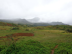
Tobias Fornier, officially the Municipality of Tobias Fornier,, is a 4th class municipality in the province of Antique, Philippines. According to the 2020 census, it has a population of 33,816 people, making it the ninth most populous municipality in the province of Antique.

<span class="mw-page-title-main">Valderrama, Antique</span> Municipality in Antique, Philippines

Valderrama, officially the Municipality of Valderrama, is a 4th class municipality in the province of Antique, Philippines. According to the 2020 census, it has a population of 19,971 people. Making it 15th most populous municipality in the province of Antique and the second largest municipality in terms of land area, with a total area of 273.79 square kilometers.

<span class="mw-page-title-main">Caibiran</span> Municipality in Biliran, Philippines

Caibiran, officially the Municipality of Caibiran, is a 5th class municipality in the province of Biliran, Philippines. According to the 2020 census, it has a population of 24,167 people. The town's populace predominantly speak Waray language.

<span class="mw-page-title-main">Culaba</span> Municipality in Biliran, Philippines

Culaba, officially the Municipality of Culaba, is a 5th class municipality in the province of Biliran, Philippines. According to the 2020 census, it has a population of 12,972 people.The town's populace predominantly speak Waray language.

<span class="mw-page-title-main">Maripipi</span> Municipality in Biliran, Philippines

Maripipi, officially the Municipality of Maripipi, is a 5th class municipality in the province of Biliran, Philippines. According to the 2020 census, it has a population of 6,373 people. The town's populace predominantly speak Waray language.

<span class="mw-page-title-main">Zarraga</span> Municipality in Iloilo, Philippines

Zarraga, officially the Municipality of Zarraga, is a 4th class municipality in the province of Iloilo, Philippines. According to the 2020 census, it has a population of 27,305 people.

References

  1. Municipality of San Remigio | (DILG)
  2. "2015 Census of Population, Report No. 3 – Population, Land Area, and Population Density" (PDF). Philippine Statistics Authority. Quezon City, Philippines. August 2016. ISSN   0117-1453. Archived (PDF) from the original on May 25, 2021. Retrieved July 16, 2021.
  3. 1 2 3 4 Census of Population (2020). "Region VI (Western Visayas)". Total Population by Province, City, Municipality and Barangay. Philippine Statistics Authority . Retrieved 8 July 2021.
  4. "PSA Releases the 2018 Municipal and City Level Poverty Estimates". Philippine Statistics Authority. 15 December 2021. Retrieved 22 January 2022.
  5. Tenerife, Eric (September 13, 1988). "Antique mayor, aides slain". Manila Standard . Standard Publications, Inc. p. 6. Retrieved January 21, 2023.
  6. Kua, Nixon; Ignacio, Bert (September 16, 1988). "2 rebels yield, one captured". Manila Standard . Standard Publications, Inc. p. 6. Retrieved January 21, 2023.
  7. "Province: Antique". PSGC Interactive. Quezon City, Philippines: Philippine Statistics Authority . Retrieved 12 November 2016.
  8. "San Remigio: Average Temperatures and Rainfall". Meteoblue. Retrieved May 1, 2020.
  9. "Municipal: San Remigio, Antique". PSGC Interactive. Quezon City, Philippines: Philippine Statistics Authority . Retrieved 8 January 2016.
  10. 1 2 Census of Population and Housing (2010). "Region VI (Western Visayas)". Total Population by Province, City, Municipality and Barangay. National Statistics Office . Retrieved 29 June 2016.
  11. Census of Population (2015). "Region VI (Western Visayas)". Total Population by Province, City, Municipality and Barangay. Philippine Statistics Authority . Retrieved 20 June 2016.
  12. Censuses of Population (1903–2007). "Region VI (Western Visayas)". Table 1. Population Enumerated in Various Censuses by Province/Highly Urbanized City: 1903 to 2007. National Statistics Office.
  13. "Province of Antique". Municipality Population Data. Local Water Utilities Administration Research Division. Retrieved 17 December 2016.
  14. "Poverty incidence (PI):". Philippine Statistics Authority. Retrieved December 28, 2020.
  15. "Estimation of Local Poverty in the Philippines" (PDF). Philippine Statistics Authority. 29 November 2005.
  16. "2003 City and Municipal Level Poverty Estimates" (PDF). Philippine Statistics Authority. 23 March 2009.
  17. "City and Municipal Level Poverty Estimates; 2006 and 2009" (PDF). Philippine Statistics Authority. 3 August 2012.
  18. "2012 Municipal and City Level Poverty Estimates" (PDF). Philippine Statistics Authority. 31 May 2016.
  19. "Municipal and City Level Small Area Poverty Estimates; 2009, 2012 and 2015". Philippine Statistics Authority. 10 July 2019.
  20. "PSA Releases the 2018 Municipal and City Level Poverty Estimates". Philippine Statistics Authority. 15 December 2021. Retrieved 22 January 2022.
  21. "San Remigio". Official Antique Website. 2012. Retrieved 11 February 2013.