
Utah is a landlocked state in the Mountain West subregion of the Western United States. It is bordered to its east by Colorado, to its northeast by Wyoming, to its north by Idaho, to its south by Arizona, and to its west by Nevada. Utah also touches a corner of New Mexico in the southeast. Of the fifty U.S. states, Utah is the 13th-largest by area; with a population over three million, it is the 30th-most-populous and 11th-least-densely populated. Urban development is mostly concentrated in two areas: the Wasatch Front in the north-central part of the state, which is home to roughly two-thirds of the population and includes the capital city, Salt Lake City; and Washington County in the southwest, with more than 180,000 residents. Most of the western half of Utah lies in the Great Basin.

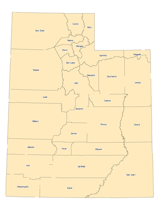
Emery County is a county in east-central Utah, United States. As of the 2020 United States Census, the population was 9,825. Its county seat is Castle Dale, and the largest city is Huntington.

Grand County is a county on the east central edge of the U.S. state of Utah, United States. As of the 2020 United States Census, the population was 9,669. Its county seat and largest city is Moab.

Millard County is a county in the U.S. state of Utah. As of the 2020 United States Census, the population was 12,975. Its county seat is Fillmore, and the largest city is Delta.
Piute County is a county in south-central Utah, United States. As of the 2020 United States Census, the population was 1,438, making it the second-least populous county in Utah. The county seat is Junction, and the largest town is Circleville.

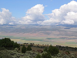
Rich County is a county in the U.S. state of Utah. As of the 2020 United States Census, the population was 2,510, making it the third-least populous county in Utah. Its county seat is Randolph, and the largest town is Garden City. The county was created in 1864. It was named for an early LDS apostle, Charles C. Rich.

Summit County is a county in the U.S. state of Utah, occupying a rugged and mountainous area. As of the 2020 United States Census, the population was 42,357. Its county seat is Coalville, and the largest city is Park City.

Sanpete County is a county in the U.S. state of Utah. As of the 2020 United States Census, the population was 28,437. Its county seat is Manti, and its largest city is Ephraim. The county was created in 1850.

Sevier County is a county in Utah, United States. As of the 2020 United States Census, the population was 21,522. Its county seat and largest city is Richfield.

Uintah County is a county in the U.S. state of Utah. As of the 2020 United States Census the population was 35,620. Its county seat and largest city is Vernal. The county was named for the portion of the Ute Indian tribe that lived in the basin.
Washington County is a county in the southwestern corner of Utah, United States. As of the 2020 United States Census, the population was 180,279, making it the fifth-most populous county in Utah. Its county seat and largest city is St. George. The county was created in 1852 and organized in 1856. It was named after the first President of the United States, George Washington. A portion of the Paiute Indian Reservation is in western Washington County. Washington County comprises the St. George, UT Metropolitan Statistical Area.

Wayne County is a county in the U.S. state of Utah. As of the 2020 census, the population was 2,486, making it the fourth-least populous county in Utah. Its county seat is Loa.

Hurricane is a city in Washington County, Utah, United States. Its population was 20,036 as of the 2020 United States Census estimates. The Hurricane valley makes up the easternmost part of the St. George metropolitan area and is near Zion National Park. Hurricane is known for its historic peach and pecan orchards, open space, green fields and small-town charm, although like much of southwestern Utah, the Hurricane valley continues to experience significant population growth.

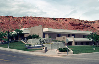
St. George is a city in and the county seat of Washington County, Utah, United States. Located in southwestern Utah on the Arizona border, it is the principal city of the St. George Metropolitan Statistical Area (MSA). The city lies in the northeasternmost part of the Mojave Desert, immediately south of the Pine Valley Mountains, which mark the southern boundary of the Great Basin. St. George lies slightly northwest of the Colorado Plateau, which ends at the Hurricane Fault. The city is 118 miles (190 km) northeast of Las Vegas, Nevada, and 300 miles (480 km) south-southwest of Salt Lake City, Utah, on Interstate 15.

Sand Hollow State Park is a state park located in Utah, USA, featuring a 1,322-acre (535 ha) reservoir and an extensive off highway vehicle recreation area on Sand Mountain. The park is near the town of Hurricane.
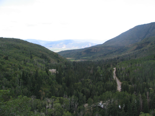
The landlocked U.S. state of Utah is known for its natural diversity and is home to features ranging from arid deserts with sand dunes to thriving pine forests in mountain valleys. It is a rugged and geographically diverse state at the convergence of three distinct geological regions: the Rocky Mountains, the Great Basin, and the Colorado Plateau.

State Route 7 (SR-7), also known as Southern Parkway, is a 26.1-mile (42.0 km) east-west state highway in southern Washington County in the extreme southwestern portion of the US state of Utah. It connects the southern periphery of St. George with Hurricane, while providing access to the St. George Regional Airport.

Fred Hayes State Park at Starvation is a state park in Duchesne County, Utah, United States, featuring the 3,495-acre (1,414 ha) Starvation Reservoir. The park is 4 miles (6.4 km) northwest of the city of Duchesme.
Wasatch Mountain State Park is a state park of Utah, United States, located in the northern part of the state within the Wasatch Back area on the north and west edges of the Heber Valley in Wasatch County near the city of Midway.
The Washington County Water Conservancy District (WCWCD) is a water district covering Washington County, Utah. It was formed in 1962 by local petition. The district provides wholesale water to the cities of St. George, Washington, Hurricane, Santa Clara, Ivins, Toquerville, La Verkin, Leeds, and the town of Virgin. The cities are required to engage in water conservation and recycling, and the district is required to develop water sources to meet the needs determined by city governments. The district also supplies drinking water to retail customers in the unincorporated areas of Sky Ranch, Cliffdweller Ranch, Casa de Oro, and (seasonally) Kolob.


