Sandgate Castle is an artillery fort originally constructed by Henry VIII in Sandgate in Kent, between 1539 and 1540. It formed part of the King's Device programme to protect England against invasion from France and the Holy Roman Empire, and defended a vulnerable point along the coast. It comprised a central stone keep, with three towers and a gatehouse. It could hold four tiers of artillery, and was fitted with a total of 142 firing points for cannon and handguns.
Sandgate was taken by Parliament in 1642 at the start of the first English Civil War, and was seized by Royalist rebels in the second civil war of 1648. The castle was extensively redesigned between 1805 and 1808 during the Napoleonic Wars. The height of the castle was significantly reduced and the keep was turned into a Martello tower; when the work was completed, it was armed with ten 24-pounder (11kg) guns and could hold a garrison of 40 men.
The castle had begun to suffer damage from the sea by the early 17th century, and by the middle of the 19th century, the receding coastline had reached the edge of the castle walls. The high costs of repair contributed to the government's decision to sell the site off in 1888. It was initially bought by a railway company and then passed into private ownership.
Coastal erosion continued and by the 1950s, the southern part of the castle had been destroyed by the sea. The remaining castle was restored between 1975 and 1979 by Peter and Barbara McGregor, who turned the keep into a private residence. In the 21st century, Sandgate remains in private ownership, and is protected under UK law as a grade I listed building.
History
16th century
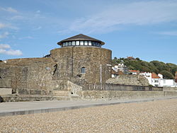
The keep (left) and gatehouse (right) in 2009
Sandgate Castle was built as a consequence of international tensions between England, France and the Holy Roman Empire in the final years of the reign of King Henry VIII. Traditionally the Crown had left coastal defences to the local lords and communities, only taking a modest role in building and maintaining fortifications, and while France and the Empire remained in conflict with one another, maritime raids were common but an actual invasion of England seemed unlikely.[1] Modest defences, based around simple blockhouses and towers, existed in the south-west and along the Sussex coast, with a few more impressive works in the north of England, but in general the fortifications were very limited in scale.[2]
In 1533, Henry broke with Pope Paul III in order to annul the long-standing marriage to his wife, Catherine of Aragon and remarry.[3] Catherine was the aunt of Charles V, the Holy Roman Emperor, and he took the annulment as a personal insult.[4] This resulted in France and the Empire declaring an alliance against Henry in 1538, and the Pope encouraging the two countries to attack England.[5] An invasion of England appeared certain.[6] In response, Henry issued an order, called a "device", in 1539, giving instructions for the "defence of the realm in time of invasion" and the construction of forts along the English coastline.[7]
Sandgate was intended to defend a vulnerable point along the Kent cliffs, just west of Folkestone, where an enemy force could potentially land and make their way easily further inland.[8] Sandgate's construction was supervised by the Moravian engineer Stefan von Haschenperg, and Thomas Cockys and Richard Keys acted as commissioners for the project.[9] In the initial stages of the work in 1539, a team of 237 men were employed, with masons, quarrymen, limeburners and wood fellers preparing the site; the masons were drawn from as far away as Somerset and Gloucestershire.[10] By the summer, over 500 were at work, including labourers, bricklayers, carpenters and sawyers.[11] After a pause during the winter months, work picked up again in the summer of the next year, with 630 working on the castle that July.[11]
The castle's foundations rested on the underlying shingle of the beach.[12] The walls were made from Kentish ragstone, mostly roughly laid, with some work using finer ashlar, with Caen stone used in the detailing.[12] Most of the ragstone was collected from the local beaches, where there were suitable outcrops to the west and east of the site.[13] 459 tons of Caen stone was recycled from the priories of Christ Church and Horton, which had recently been dissolved by Henry.[13] In total, 147,000 bricks were used, produced at 13 different brickyards, and 44,000 tiles, mostly manufactured in Wye, along with 1,829 loads of lime, 110 tons of coal and 979 tons of timber.[14] The total cost of the project came to £5,584.[15][lower-alpha 1]
At the centre of the new castle was a circular keep, with three ovoid towers and bastions around it on the northwest, northeast and south sides, and a gatehouse to the north.[17] These were surrounded by two curtain walls, forming a triangular inner and outer ward.[18] Covered stone passageways, three storeys high, linked the towers, the keep and the gatehouse.[19] The outer ward was grassed over, with a stone cesspool by the side of the north-east tower, linked by sewers to the inside of the castle.[20] The castle was entered through a doorway in the rear of the gatehouse, originally called the "Half Moon", linked by a stairway in the covered passageway to the keep.[21] There were four tiers of guns in the finished castle, from the ground level up to the roof of the keep, and a total of 142 firing points for cannon and handguns; their design closely resembling those at nearby Walmer and Deal castles.[22]
Sandgate was completed by the autumn of 1540; Henry may have come to the castle when he was visiting Folkestone in May 1542.[23]Elizabeth I visited the fortification in 1573, and also used it to imprison the courtier Thomas Keyes for a period, after he married Lady Mary Grey against the Queen's wishes.[24] In 1593, the castle was reported to be equipped with seven artillery pieces - one culverin, two demi-culverins, three sakers and one minion - along with muskets, bows and arrows.[25]
17th–18th centuries
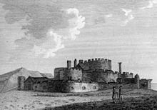
Depiction of the castle in 1762
In 1609, the garrison comprised a captain and his lieutenant, five soldiers, two porters and ten gunners.[26] The mortar used in the castle was particularly poor, and had begun to seriously decay by 1616.[27] A survey that year showed the castle to be substantially dilapidated, with the cost of the proposed repairs estimated at £260, and noted that a 100 feet (30m) gun platform for ten weapons had been built along the southern walls to replace the original southern battery.[28] A 1623 report echoed the same problems, noting that the sea had caused a third of the southern wall to collapse; the necessary repairs, including strengthening the walls, were projected at £560.[29][lower-alpha 1]
Four years later, amid fears of war with France and Spain, the castle's captain, Richard Chalcroft, reported that the fortification was in such a poor condition that "neither habitable or defensible against any assault, nor any way fit to command the roads".[30] An inspection team observed that it was straightforward to climb over the castle's ruined walls and rotten timbers, and that as a result its artillery had been dismounted and placed along the beach instead.[30] The castle was probably not repaired, however, until after 1638.[31]
Sandgate Castle was seized in 1642 by Parliamentary forces at the start of the first English Civil War between the supporters of King Charles I and Parliament, although its captain, Richard Hippesley, remained in post.[32] The war ended in 1646 but, after the few years of unsteady peace, the Second Civil War broke out in 1648. The Parliamentary navy was based in Kent, protected by the other Henrician castles of Walmer, Deal and Sandown, but by May a Royalist insurrection was under way across the county, and the fleet joined the rebellion.[33] Sandgate and its sister castles were occupied by the Royalists.[34] Parliament defeated the wider insurgency at the Battle of Maidstone at the start of June, however, and then sent a force under the command of Colonel Rich to deal with the Kentish castles.[35] Sandgate was still occupied by the Royalists that August, when Rich sent forces to prevent its garrison intervening to disrupt his assault on Deal and Sandown, but was recaptured soon after.[36]
During the interregnum, Hippesley initially continued as captain of Sandgate, until he was replaced in 1653, resulting in complaints from him that he had been unfairly treated and that he was owed money by Parliament.[37] During this period the garrison was increased to include a governor, two corporals, twenty soldiers and three gunners.[26] When Charles II was restored to the throne in 1660, Sandgate and the other Device Forts initially remained at the heart of the south coast defences, but by now their design was antiquated.[38] The garrison was cut back to its pre-war levels, and then reduced further in 1682 to only ten men.[25] Sandgate had fallen into a poor condition, and £200 was assigned in 1663 for the repair of the castle, to be met partially from the proceeds of lands around Sandgate confiscated from former supporters of Parliament.[39][lower-alpha 1]
19th century
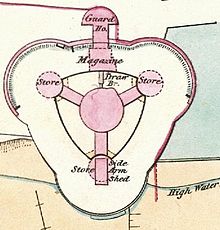
1867 plan of the castle; north-west and north-east towers and gatehouse at the top
Sandgate Castle was still in use during the Napoleonic Wars at the start of the 19th century, but was heavily rebuilt. Brigadier-General William Twiss surveyed the south coast in 1804, and proposed building a series of 58 new defensive towers along it, as part of which he proposed converted Sandgate into a "secure sea battery".[40] After some opposition, and many delays within the War Office, the work on the castle finally began in 1805.[41]
The project lowered the height of the castle considerably, destroying much of the fortification in the process.[22] The upper storeys of the keep, the towers, the covered passageways and the gatehouse were all demolished, along with some of the buildings in the inner ward.[42] The resulting rubble was used to backfill the outer ward, raising its height and effectively turning the inner ward into a dry moat.[42] The inner curtain wall was reduced to one storey in height, and the outer curtain wall was refaced.[43] An esplanade and wall-walk were built around the remaining outer walls, which supported at least eight gun emplacements.[44]
The circular keep was turned into a Martello tower, a type of Napoleonic artillery fortification.[22] It was now only two storeys tall, although remaining original interior walls and doorways largely survived untouched.[45] It was accessed on the first floor via an unusual sliding drawbridge, which was supported on rails and could retract into the floor, and the different storeys were linked by a spiral staircase.[46] The ground floor of the keep included a brick-built magazine, and the roof, supported by a central pillar running up through the building, held a single, large gun emplacement.[47]
The north-east and north-west towers, now only one-storey tall, were covered with turf, turning the rear of the outer ward into a flat, grassed esplanade.[48] The southern tower was reduced in height to two storeys, but remained in use as a gun platform.[49] The covered corridors between the keep and the towers were now one-storey high as well, linking to the buried towers in the north-east and north-west bastions.[50] The upper storeys of the gatehouse were rebuilt, although the ground floor remained in its 16th-century condition.[51]
The modified castle was completed by 1808, and held eight 24-pounder (11kg) guns along the outer wall, a gun on the roof of the southern bastion, and another on top of the keep itself.[52] The new castle could hold a garrison of 40 men.[52]
In 1859, the castle was re-equipped with heavier artillery, a combination of 32-pounder (15kg) and 68-pounder (31kg) guns.[53] A new magazine was constructed, comprising a large, brick-built building divided into three rooms for storing gunpowder, specially designed to keep the powder dry.[54] The exterior gun emplacements were also redesigned, reusing the 1806 foundations; the two surviving emplacements, in the north-east and north-west bastions, date from 1859.[44]
Coastal erosion remained a problem. By the middle of the century, the tides had reached the southern edge of the castle, and an 1866 report stated that the walls had been undermined by the sea.[55] Despite protective piles being driven around the castle, it was badly affected by flooding in 1875 and 1878, creating serious fissures in the stonework.[56] The high costs of maintaining the property, combined with its dwindling utility, encouraged the government to sell the castle to the South Eastern Railway company in 1888, who intended to turn it into a railway station.[56] It was then sold to private owners and a small museum was created in the castle, which was sometimes opened to the public for an entry price of one penny.[57][lower-alpha 2]
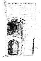
Sketches of Sandgate Castle in 1893 by E. Kennett, from the north-east...
...and the south-east
The main doorway into the gatehouse...
...and interior...
and the keep.
20th–21st centuries
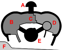
Plan of Sandgate Castle in the 21st century; A: gatehouse; B: north-west bastion, covered; C: magazine, covered; D: north-east bastion, exposed; E: keep; F: beach and sea-wall
The receding coast line continued to threaten Sandgate Castle, and severe storms in 1927 and 1950 undermined large parts of the castle.[59] By the time that a new seawall was built in the early 1950s, the southern third of the castle had been entirely destroyed.[59]
The part of the 1806 esplanade around the northeast bastion was excavated, revealing the lower 16th-century stonework of the tower and the east side of the 1859 magazine, and a retaining wall was built to support the newly exposed walls.[61] This created two levels in the outer bailey: a higher level on the western side, which still covered the northwest tower, and a lower one on the eastern.[61] The keep was turned into a private residence, with a new sun room built on top of the gun platform.[62]
In 2000, Lord Geoffrey Boot and his wife acquired the castle, which is now used by Boot's company, AMT South Eastern Ltd.[63]
The castle is protected under UK law as a grade I listed building.[64] The two 16th-century ledger books from the original construction, written by the project clerk Thomas Busshe, survive in the British Library.[65] They are 350 pages long, and form what the historian Peter Harrington has described as the "most complete building account of any Tudor fortification".[66]
1 2 3 Comparing early modern costs and prices with those of the modern period is challenging. £5,584 in 1540 could be equivalent to between £3.1 and £1,500 million in 2014, depending on the price comparison used. £260 in 1616 could equate to between £44,000 and £13.6 million; £560 in 123 to between £93,000 and £27.7 million; and £200 in 1663 to between £26,800 and £6 million. For comparison, the total royal expenditure on all the Device Forts across England between 1539 and 1547 came to £376,500, with St Mawes, for example, costing £5,018.[16]
↑ One penny in 1900 would be equivalent to £0.48 in 2014.[58]
Related Research Articles
Walmer Castle is an artillery fort originally constructed by Henry VIII in Walmer, Kent, between 1539 and 1540. It formed part of the King's Device programme to protect against invasion from France and the Holy Roman Empire, and defended the strategically important Downs anchorage off the English coast. Comprising a keep and four circular bastions, the moated stone castle covered 0.61 acres (0.25 ha) and had 39 firing positions on the upper levels for artillery. It cost the Crown a total of £27,092 to build the three castles of Walmer, Sandown, and Deal, which lay adjacent to one another along the coast and were connected by earthwork defences. The original invasion threat passed, but during the Second English Civil War of 1648–49, Walmer was seized by pro-Royalist insurgents and was only retaken by Parliamentary forces after several months' fighting.
White Castle, also known historically as Llantilio Castle, is a ruined castle near the village of Llantilio Crossenny in Monmouthshire, Wales. The fortification was established by the Normans in the wake of the invasion of England in 1066, to protect the route from Wales to Hereford. Possibly commissioned by William fitz Osbern, the Earl of Hereford, it comprised three large earthworks with timber defences. In 1135, a major Welsh revolt took place and in response King Stephen brought together White Castle and its sister fortifications of Grosmont and Skenfrith to form a lordship known as the "Three Castles", which continued to play a role in defending the region from Welsh attack for several centuries.
Deal Castle is an artillery fort constructed by Henry VIII in Deal, Kent, between 1539 and 1540. It formed part of the King's Device programme to protect against invasion from France and the Holy Roman Empire, and defended the strategically important Downs anchorage off the English coast. Comprising a keep with six inner and outer bastions, the moated stone castle covered 0.85 acres (0.34 ha) and had sixty-six firing positions for artillery. It cost the Crown a total of £27,092 to build the three castles of Deal, Sandown and Walmer, which lay adjacent to one another along the coast and were connected by earthwork defences. The original invasion threat passed but, during the Second English Civil War of 1648–49, Deal was seized by pro-Royalist insurgents and was only retaken by Parliamentary forces after several months' fighting.
The Device Forts, also known as Henrician castles and blockhouses, were a series of artillery fortifications built to defend the coast of England and Wales by Henry VIII. Traditionally, the Crown had left coastal defences in the hands of local lords and communities but the threat of French and Spanish invasion led the King to issue an order, called a "device", for a major programme of work between 1539 and 1547. The fortifications ranged from large stone castles positioned to protect the Downs anchorage in Kent, to small blockhouses overlooking the entrance to Milford Haven in Pembrokeshire, and earthwork bulwarks along the Essex coast. Some forts operated independently, others were designed to be mutually reinforcing. The Device programme was hugely expensive, costing a total of £376,000 ; much of this was raised from the proceeds of the Dissolution of the Monasteries a few years before.
Camber Castle, also known formerly as Winchelsea Castle, is a 16th-century Device Fort, built near Rye by King Henry VIII to protect the Sussex coast of England against French attack. The first fortification on the site was a small, round artillery tower, constructed by Henry between 1512 and 1514, overlooking the Camber anchorage and the entrance to Rye Harbour. In 1539, increasing tensions with France encouraged Henry to rethink his coastal defence plans, and Camber Castle was rebuilt and extended over the next year under the direction of the Moravian engineer, Stefan von Haschenperg. The results were considered unsatisfactory and further work was carried out from 1542 to 1543, at great expense, to rectify the problems. The result was a large, concentric artillery fort, with a central keep, surrounded by four circular bastions and a circular entrance bastion, built from stone and brick.
Hurst Castle is an artillery fort established by Henry VIII on the Hurst Spit in Hampshire, England, between 1541 and 1544. It formed part of the king's Device Forts coastal protection programme against invasion from France and the Holy Roman Empire, and defended the western entrance to the Solent waterway. The early castle had a central keep and three bastions, and in 1547 was equipped with 26 guns. It was expensive to operate due to its size, but it formed one of the most powerful forts along the coast. During the English Civil War of the 1640s, Hurst was held by Parliament and was used briefly to detain King Charles I before his execution in 1649. It continued in use during the 18th century but fell into disrepair, the spit being frequented by smugglers.
Southsea Castle, historically also known as Chaderton Castle, South Castle and Portsea Castle, is an artillery fort originally constructed by Henry VIII on Portsea Island, Hampshire, in 1544. It formed part of the King's Device programme to protect against invasion from France and the Holy Roman Empire, and defended the Solent and the eastern approach to Portsmouth. The castle had a square central keep, two rectangular gun platforms to the east and west, and two angled bastions to the front and rear, and was an early English example of the trace italienne-style of fortification popular on the Continent. The Cowdray engraving of the Battle of the Solent in 1545 depicted Henry VIII visiting the castle. Despite several serious fires, it remained in service and saw brief action at the start of the English Civil War in 1642 when it was stormed by Parliamentary forces.
Calshot Castle is an artillery fort constructed by Henry VIII on the Calshot Spit, Hampshire, England, between 1539 and 1540. It formed part of the King's Device programme to protect against invasion from France and the Holy Roman Empire and defend Southampton Water as it met the Solent. The castle had a keep at its centre, surrounded by a curtain wall and a moat. Initially heavily armed, it had a garrison of 16 men and as many as 36 artillery guns. The castle continued in use for many years, surviving the English Civil War intact and being extensively modernised in the 1770s. During the 19th century, Calshot Castle was used by the coastguard as a base for combating smuggling. In 1894, however, fresh fears of a French invasion led to it being brought back into use as an artillery fort: a large coastal battery was constructed alongside the older castle and a boom built across Southampton Water, controlled from the castle.
Portland Castle is an artillery fort constructed by Henry VIII on the Isle of Portland, Dorset, between 1539 and 1541. It formed part of the King's Device programme to protect against invasion from France and the Holy Roman Empire, and defended the Portland Roads anchorage. The fan-shaped castle was built from Portland stone, with a curved central tower and a gun battery, flanked by two angular wings. Shortly after its construction it was armed with eleven artillery pieces, intended for use against enemy shipping, operating in partnership with its sister castle of Sandsfoot on the other side of the anchorage. During the English Civil War, Portland was taken by the Royalist supporters of King Charles I, and then survived two sieges before finally surrendering to Parliament in 1646.
Pendennis Castle is an artillery fort constructed by Henry VIII near Falmouth, Cornwall, England between 1540 and 1542. It formed part of the King's Device programme to protect against invasion from France and the Holy Roman Empire, and defended the Carrick Roads waterway at the mouth of the River Fal. The original, circular keep and gun platform was expanded at the end of the century to cope with the increasing Spanish threat, with a ring of extensive stone ramparts and bastions built around the older castle. Pendennis saw service during the English Civil War, when it was held by the Royalists, and was only taken by Parliament after a long siege in 1646. It survived the interregnum and Charles II renovated the fortress after his restoration to the throne in 1660.
Denbigh Castle and town walls were built to control the lordship of Denbigh after the Conquest of Wales by Edward I of England in 1282. The lands were granted to Henry de Lacy, Earl of Lincoln, who began to build a new walled town, colonised by immigrants from England, protected by a substantial castle and surrounded by deer parks for hunting. The work had not been completed by 1294, when the Welsh temporarily seized the castle during the Madog ap Llywelyn revolt. The defences continued to be improved, although the castle was not completely finished by the time of Henry's death in 1311.
St Mawes Castle is an artillery fort constructed by Henry VIII near Falmouth, Cornwall, between 1540 and 1542. It formed part of the King's Device programme to protect against invasion from France and the Holy Roman Empire, and defended the Carrick Roads waterway at the mouth of the River Fal. The castle was built under the direction of Thomas Treffry to a clover leaf design, with a four-storey central tower and three protruding, round bastions that formed gun platforms. It was initially armed with 19 artillery pieces, intended for use against enemy shipping, operating in partnership with its sister castle of Pendennis on the other side of the estuary. During the English Civil War, St Mawes was held by Royalist supporters of King Charles I, but surrendered to a Parliamentary army in 1646 in the final phase of the conflict.
Sandown Castle was an artillery fort constructed by Henry VIII in Sandown, Kent, between 1539 and 1540. It formed part of the King's Device programme to protect against invasion from France and the Holy Roman Empire, and defended the strategically important Downs anchorage off the English coast.
Sandown Castle was a Device Fort built at Sandown on the Isle of Wight by Henry VIII in 1545 to protect against the threat of French attack. Constructed from stone with angular bastions, its design was a hybrid of Italian military architectural thinking with traditional English military design. The site was raided by a French force that summer while the fortification was still being constructed. The site suffered from coastal erosion and the castle was demolished in 1631.
Hull Castle was an artillery fort in Kingston upon Hull in England. Together with two supporting blockhouses, it defended the eastern side of the River Hull, and was constructed by King Henry VIII to protect against attack from France as part of his Device programme in 1542. The castle had two large, curved bastions and a rectangular keep at its centre; the blockhouses to the north and south had three curved bastions supporting guns, and a curtain wall and moat linked the blockhouses and castle. The construction project used material from recently dissolved monasteries, and cost £21,056. The town took over responsibility for these defences in 1553, leading to a long running dispute with the Crown as to whether the civic authorities were fulfilling their responsibilities to maintain them.
Stefan von Haschenperg was a military engineer employed by Henry VIII of England in the 1540s.
St Andrew's Castle was an artillery fort constructed by Henry VIII near Hamble-le-Rice, Hampshire, between 1542 and 1543. It formed part of the King's Device programme to protect against invasion from France and the Holy Roman Empire, and defended Southampton Water near the Solent. St Andrew's comprised a keep and a gun platform, protected by a moat. The castle was decommissioned in 1642 during the English Civil War and has been largely destroyed through coastal erosion.
Milton Blockhouse was an artillery fortification constructed as part of Henry VIII's Device plan of 1539, in response to fears of an imminent invasion of England. It was built at Milton, near Gravesend in Kent at a strategic point along the River Thames, and was operational by 1540. Equipped with 30 pieces of artillery and a garrison of 12 men and a captain, it was probably a two-storey, D-shaped building, designed to prevent enemy ships from progressing further up the river or landing an invasion force. It was stripped of its artillery in 1553 and was demolished between 1557 and 1558; nothing remains of the building above ground, although archaeological investigations in the 1970s uncovered parts of the blockhouse's foundations.
Gravesend Blockhouse was an artillery fortification constructed as part of Henry VIII's Device plan of 1539, in response to fears of an imminent invasion of England by European countries. It was built at Gravesend in Kent at a strategic point along the River Thames and was operational by 1540. A two-storey, D-shaped building built from brick and stone, it had a circular bastion overlooking the river and gun platforms extending out to the east and west. It functioned in conjunction with Tilbury Fort on the other side of the river, and was repaired in 1588 to deal with the threat of Spanish invasion, and again in 1667 when the Dutch navy raided the Thames. A 1778 report recommended alterations to the blockhouse and its defences, leading to the remodelling of the gun platforms and the construction of the new, larger New Tavern Fort alongside it. In the 1830s the government decided to rely entirely on the newer fort and the old blockhouse was demolished in 1844. Its remains were uncovered in archaeological excavations between 1975 and 1976.
Ashton, Robert (1994). Counter-revolution: The Second Civil War and Its Origins, 1646–8. Avon, UK: The Bath Press. ISBN9780300061147.
Biddle, Martin; Hiller, Jonathon; Scott, Ian; Streeten, Anthony (2001). Henry VIII's Coastal Artillery Fort at Camber Castle, Rye, East Sussex: An Archaeological Structural and Historical Investigation. Oxford, UK: Oxbow Books. ISBN0904220230.
Clements, Bill (2011). Martello Towers Worldwide. Barnsley, UK: Sword and Pen. ISBN9781848845350.
Darvill, Tim; McWhirr, Alan (1984). "Brick and Tile Production in Roman Britain: Models of Economic Organisation". World Archaeology. 15 (3): 239–261. doi:10.1080/00438243.1984.9979904.
Tapete, Deodato; Bromhead, Edward; Ibsen, Maia; Casagli, Nicola (2013). "Coastal Erosion and Landsliding Impact on Historic Sites in SE Britain". In Margottini, Claudio; Canuti, Paolo; Sassa, Kyoji (eds.). Landslide Science and Practice: Volume 6, Risk Assessment, Management and Migitation edited by Claudio Margottini, Paolo Canuti, Kyoji Sassa. Heidelberg, Germany: Springer. pp.451–458. ISBN9783642313196.
Thompson, M. W. (1987). The Decline of the Castle. Cambridge, UK: Cambridge University Press. ISBN1854226088.
Tomlinson, Howard (1973). "The Ordnance Office and the King's Forts, 1660–1714". Architectural History. 1: 5–25. doi:10.2307/1568302. JSTOR1568302.
Walton, Steven A. (2010). "State Building Through Building for the State: Foreign and Domestic Expertise in Tudor Fortification". Osiris. 25 (1): 66–84. doi:10.1086/657263. S2CID144384757.
This page is based on this Wikipedia article Text is available under the CC BY-SA 4.0 license; additional terms may apply. Images, videos and audio are available under their respective licenses.