
Columbus is the capital and most populous city of the U.S. state of Ohio. With a 2020 census population of 905,748, it is the 14th-most populous city in the U.S., the second-most populous city in the Midwest after Chicago, and the third-most populous U.S. state capital after Phoenix, Arizona and Austin, Texas. Columbus is the county seat of Franklin County; it also extends into Delaware and Fairfield counties. It is the core city of the Columbus metropolitan area, which encompasses ten counties in central Ohio. It had a population of 2,138,926 in 2020, making it the largest metropolitan area entirely in Ohio and 14th-largest city in the U.S.

The Scioto River is a river in central and southern Ohio more than 231 miles (372 km) in length. It rises in Hardin County just north of Roundhead, Ohio, flows through Columbus, Ohio, where it collects its largest tributary, the Olentangy River, flows south into Appalachian Ohio, and meets the Ohio River at Portsmouth. Early settlers and Native Americans used the river for shipping, but it is too small for modern commercial craft. The primary economic importance for the river now is for recreation and drinking water. It is the longest river that is entirely within Ohio.
Scioto is a word of Wyandot origin given to the Scioto River, which flows southwards from north central Ohio to the Ohio River.

Franklinton is a neighborhood in Columbus, Ohio, just west of its downtown. Settled in 1797, Franklinton is the first American settlement in Franklin County, and was the county seat until 1824. As the city of Columbus grew, the city annexed and incorporated the existing settlement in 1859. Franklinton is bordered by the Scioto River on the north and east, Harmon Avenue on the east, Stimmel Road and Greenlawn Avenue on the south, and Interstate 70 on the west. Its main thoroughfare is West Broad Street, one of the city's two main roads.

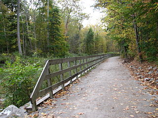
The Columbus and Franklin County Metro Parks are a group of 20 metropolitan parks in and around Columbus, Ohio. They are officially organized into the Columbus and Franklin County Metropolitan Park District. The Metro Parks system was organized in 1945 under Ohio Revised Code Section 1545 as a separate political division of the state of Ohio. The Metro Parks are overseen by a Board of Park Commissioners consisting of three citizens appointed to three-year terms without compensation by the Judge of the Probate Court of Franklin County, Ohio. The Board in turn appoints an Executive Director responsible for operations and management of the parks.

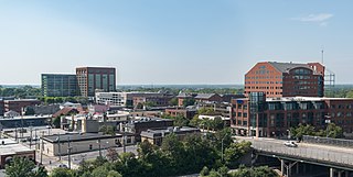
Downtown Columbus is the central business district of Columbus, Ohio. Downtown is centered on the intersection of Broad and High Streets, and encompasses all of the area inside the Inner Belt. Downtown is home to most of the tallest buildings in Columbus.
The Brewery District, traditionally known as the Old German Brewing District, is a neighborhood located in Columbus, Ohio. Located just south of the central business district and west of German Village, it is bounded by Interstate 70 on the north, South Pearl Street on the east, Greenlawn Avenue on the south, and the Scioto River on the west.
Columbus, the state capital and Ohio's largest city, has numerous neighborhoods within its city limits. Neighborhood names and boundaries are not officially defined. They may vary or change from time to time due to demographic and economic variables.
The Ohio to Erie Trail is a dedicated multi-use trail crossing Ohio from southwest to northeast, crossing 326 mi (525 km) of regional parks, nature preserves, and rural woodland.
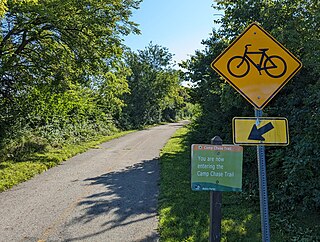
The Camp Chase Trail is a paved multi-use trail in Madison and Franklin counties in the U.S. state of Ohio. It serves as the Southwest Columbus segment of the 326-mile (525 km) Ohio to Erie Trail. The entire length of the Camp Chase Trail is part of the Great American Rail-Trail, U.S. Bicycle Route 21 and U.S. Bicycle Route 50.

The Discovery Bridge, commonly known as the Broad Street Bridge, is a bridge in Columbus, Ohio, United States, carrying Broad Street over the Scioto River and connecting Downtown Columbus to Franklinton. The bridge was named in reference to Christopher Columbus's "discovery" of the Americas; the bridge includes artistic bronze medallions featuring symbols of the explorer.

The Rich Street Bridge is a bridge in Columbus, Ohio, United States, spanning the Scioto River and connecting downtown's Rich Street to Franklinton's Town Street. It carries U.S. Route 62 (US 62) and Ohio State Route 3 (SR 3). The bridge was completed in 2012.

Genoa Park is a 2.07-acre (0.84 ha) urban park along the west bank of the Scioto River in Columbus, Ohio, United States. The park, located between Broad and Rich Streets as part of the Scioto Mile park grouping, is named after Genoa, the birthplace of Christopher Columbus and one of Columbus' sister cities. It opened in 1999.
The Scioto Mile is a collection of parks and trails along both banks of the Scioto River in Columbus, Ohio, connecting parts of the Scioto Greenway Trail with downtown Columbus and Franklinton. The nine parks cover 145 acres (59 ha).

Scioto Audubon Metro Park is a public park and nature preserve in Columbus, Ohio. The park is managed by the Columbus and Franklin County Metro Parks and is part of the Scioto Mile network of parks and trails around Downtown Columbus. The park features numerous trails, wetlands, rock climbing, volleyball and bocce courts, and numerous other amenities. At the western edge is the Grange Insurance Audubon Center, considered the first nature center built in close proximity to a downtown area.

The Scioto Mile Promenade, also known simply as the Promenade, is a public park and promenade in downtown Columbus, Ohio. The park is part of the Scioto Mile network of parks and trails around the city's downtown area, and has a riverwalk stretching along the east bank of the Scioto River, from Battelle Riverfront Park to Bicentennial Park.
MKSK is an American landscape architecture and urban design firm. The company is headquartered in Columbus, Ohio.
The Olentangy Trail, also known as the Olentangy Greenway Trail is a 13.6-mile multi-use greenway trail in Columbus, Ohio, United States. The route is along the banks of the Olentangy River.


