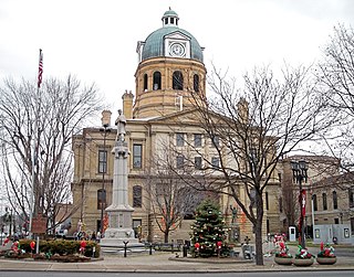
Tuscarawas County is a county located in the northeastern part of the U.S. state of Ohio. As of the 2020 census, the population was 93,263. Its county seat is New Philadelphia. Its name is a Delaware Indian word variously translated as "old town" or "open mouth". Tuscarawas County comprises the New Philadelphia–Dover, OH Micropolitan Statistical Area, which is also included in the Cleveland–Akron–Canton, OH Combined Statistical Area.

Massillon is a city in Stark County in the U.S. state of Ohio, approximately 8 miles (13 km) west of Canton, 20 miles (32 km) south of Akron, and 50 miles (80 km) south of Cleveland. The population was 32,146 at the 2020 census. Massillon is the second largest incorporated area within the Canton–Massillon metropolitan area, which includes all of Stark and Carroll counties and had a population of 401,574 in 2020.
The Buckeye Trail is a 1,444-mile (2,324 km) hiking trail and long-distance trail that loops around the state of Ohio. Part of it is on roads and part is on wooded trail. Road portions of the trail are gradually being relocated to separate trail.

Ralph Straus Regula was an American politician from Ohio. A member of the Republican Party, he served in the Ohio House of Representatives, the Ohio State Senate and the United States House of Representatives. He represented Ohio's 16th congressional district for 18 terms from 1973 to 2009. In the 110th Congress (2007–2009), he was the second longest serving Republican member of the House of Representatives.
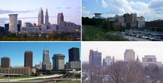
The region Northeast Ohio, in the US state of Ohio, in its most expansive usage contains six metropolitan areas along with eight micropolitan statistical areas. Most of the region is considered either part of the Cleveland–Akron–Canton, OH Combined Statistical Area and media market or the Youngstown–Warren, OH-PA Combined Statistical Area and media market. In total the region is home to 4,502,460 residents. It is also a part of the Great Lakes megalopolis, containing over 54 million people. Northeast Ohio also includes most of the area known historically as the Connecticut Western Reserve. In 2011, the Intelligent Community Forum ranked Northeast Ohio as a global Smart 21 Communities list. It has the highest concentration of Hungarian Americans in the United States.

Cuyahoga Valley National Park is an American national park that preserves and reclaims the rural landscape along the Cuyahoga River between Akron and Cleveland in Northeast Ohio.

State Route 21 (SR 21) is a north–south state highway in northeastern Ohio. The southern terminus is north of Strasburg on U.S. Route 250. The northern terminus is at an interchange with Interstate 77 in Cuyahoga Heights.
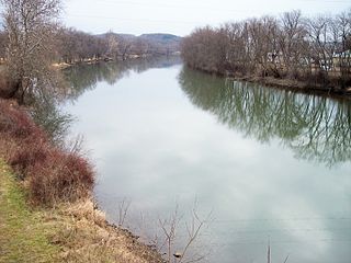
The Tuscarawas River is a principal tributary of the Muskingum River, 129.9 miles (209 km) long, in northeastern Ohio in the United States. Via the Muskingum and Ohio rivers, it is part of the watershed of the Mississippi River, draining an area of 2,590 square miles (6,700 km2) on glaciated and unglaciated portions of the Allegheny Plateau.

The Ohio and Erie Canal was a canal constructed during the 1820s and early 1830s in Ohio. It connected Akron with the Cuyahoga River near its outlet on Lake Erie in Cleveland, and a few years later, with the Ohio River near Portsmouth. It also had connections to other canal systems in Pennsylvania.
Irishtown Bend is the name given to both a former Irish American neighborhood and a landform located on the Flats of the west bank of the Cuyahoga River in the city of Cleveland in the U.S. state of Ohio in the United States. The landform consists of a tight meander in the Cuyahoga River, and the steep hillside above this meander.
Tinker's Creek, in Cuyahoga, Summit and Portage counties, is the largest tributary of the Cuyahoga River, providing about a third of its flow into Lake Erie.

Old Brooklyn is a neighborhood on the West Side of Cleveland, Ohio, United States, located approximately five miles south of downtown Cleveland. It extends east-to-west from the Cuyahoga River to the city of Brooklyn and north-to-south from the Brookside Park Valley to the city of Parma.
Summit Metro Parks is a Metroparks system serving the citizens of Summit County, Ohio by managing 14,000 acres (5,700 ha) in 16 developed parks, six conservation areas and more than 150 miles (240 km) of trails, with 22.4 miles (36.0 km) of the Ohio & Erie Canal Towpath Trail.

This is a list of properties and districts in Ohio that are listed on the National Register of Historic Places. There are over 4.000 in total. Of these, 73 are National Historic Landmarks. There are listings in each of Ohio's 88 counties.

The Old Erie Canal State Historic Park encompasses a 36-mile (58 km) linear segment of the original Erie Canal's Long Level section. It extends westward from Butternut Creek in the town of DeWitt, just east of Syracuse, to the outskirts of Rome, New York. The park includes restored segments of the canal's waterway and towpath which were in active use between 1825 and 1917. It is part of the New York State Park system.

Whiskey Island is a peninsula at the mouth of the Cuyahoga River at Lake Erie in Cleveland, Ohio. Its current configuration was created in 1827 when the river's mouth was moved to its present location. Part of the city's Cuyahoga Valley neighborhood, the peninsula is 1 mile (1.6 km) long and 0.3 miles (0.48 km) at its widest, bounded by Lake Erie to the north, West 54th Street on the west (roughly), and the Cuyahoga River to the south and east.
The Ohio and Erie Canalway National Heritage Area is a federally designated National Heritage Area in northeastern Ohio that incorporates the routes of the Ohio and Erie Canal, the Cuyahoga Valley Scenic Railroad, and portions of Cuyahoga Valley National Park.The heritage area follows the path of the canal along the Cuyahoga River for 110 miles (180 km) from Cleveland through Akron and Massillon to New Philadelphia, while the railway runs from Cleveland to Akron to Canton.

The Ohio & Erie Canalway Scenic Byway is a 110-mile (177 km) scenic byway located within the Ohio & Erie Canalway National Heritage Area in Northeast Ohio.
Zoarville is an unincorporated community in Tuscarawas County, in the U.S. state of Ohio.
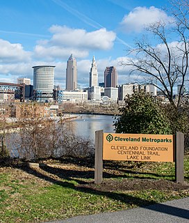
The Cleveland Foundation Centennial Lake Link Trail, originally known as the Lake Link Trail, is a cycling, hiking, and walking trail located in the city of Cleveland, Ohio, in the United States. Owned by the city of Cleveland and maintained by Cleveland Metroparks, the trail runs along the former track bed of the Cleveland and Mahoning Valley Railroad. The trail is named for The Cleveland Foundation, a local community foundation which donated $5 million toward the trail's construction. The southern leg of the 1.3-mile (2.1 km) trail opened in August 2015, and the northern leg in August 2017. The middle leg will begin construction once the Irishtown Bend hillside is stabilized. A bridge connecting the trail to Whiskey Island will begin construction in Spring 2019 and will be completed in early Summer 2020.
