
Bahawalpur is a city in the Punjab province of Pakistan. It is one of the ten largest cities of Pakistan and 6th most populous city of Punjab. Bahawalpur is the capital of Bahawalpur Division.

Gujrat is a city in the Pakistani province of Punjab. It is the headquarters of the Gujrat District and the 20th largest city in Pakistan, with a population of over 390,000 in 2017. Along with the nearby cities of Sialkot and Gujranwala, Gujrat forms part of the Golden Triangle of industrial cities with export-oriented economies.

West Punjab was a province in the Dominion of Pakistan from 1947 to 1955. It was established from the western-half of British Punjab, following the independence of Pakistan. The province covered an area of 159,344 km sq, including much of the current Punjab province and the Islamabad Capital Territory, but excluding the former Princely state of Bahawalpur. Lahore, being the largest city and the cultural centre, served as the capital of the province. The province was composed of four divisions and was bordered by the state of Bahawalpur to the south-east, the province of Baluchistan to the south-west and Sind to the south, North-West Frontier Province to the north-west, and Azad Jammu and Kashmir to the north. It shared International border with Indian state of East Punjab to the east and Indian-administered Jammu & Kashmir to the north-east. It was dissolved and merged into West Pakistan upon creation of One Unit Scheme, in 1955.
Jhelum District, is partially in Pothohar Plateau, and partially in Punjab Plain of the Punjab province of Pakistan. Jhelum is one of the oldest districts of Punjab. It was established on 23 March 1849. Jhelum is known for providing many soldiers to the British and later to the Pakistan armed forces due to which it is also known as 'city of soldiers' or 'land of martyrs and warriors'. The district of Jhelum stretches from the river Jhelum almost to the Indus. Salt is quarried at the Mayo mine in the Salt Range. There are two coal mines in the district from which the North-Western railway obtains parts of its supply. These are the only coal mines in Punjab province which are in working condition. The chief center of the salt trade is Pind Dadan Khan. The district is crossed by the main line of the North-Western railway and also traversed along the south by a branch line. It is located in the north of the Punjab province, Jhelum district is bordered by Sargodha and Mandi Bahauddin to its south, Khushab to its southwest, Jhelum River to its south and east, Gujrat to its east, Chakwal to its west, Mirpur to its northeast, and Rawalpindi to its north.

Lahore District is a district in Punjab, Pakistan, consisting of the provincial capital, Lahore and surrounding areas. It is the most populous district of Pakistan, with a population of over 11 million in 2017.
Muzaffargarh District is a district of the Punjab province of Pakistan. Its capital is Muzaffargarh city. It lies on the bank of the Chenab River.
Jhelum is a city on the East Bank of the Jhelum River, which is located in the district of Jhelum in the North of Punjab, Pakistan. It is the 44th largest city of Pakistan by population. Jhelum is known for providing many soldiers to the British Army before independence, and later to the Pakistan armed forces, due to which it is also known as City of Soldiers or Land of Martyrs and Warriors.

Nowshera is the capital city of Nowshera District in the Khyber Pakhtunkhwa province of Pakistan. It is the 78th largest city in Pakistan and ninth largest city in the province of Khyber Pakhtunkhwa.

Jhang is the capital city of Jhang District in the central portion of the province of Punjab, Pakistan. Situated on the east bank of the Chenab river, it is the 18th largest city of Pakistan by population.
Khushab District, is a district in the province of Punjab, Pakistan, with its administrative capital in Jauharabad. The district is named after the historical city of Khushab located within its boundaries. According to the 1998 census, the population was 905,711 with 24.76% living in urban areas. The district consists of four tehsils: Khushab, Noorpur Thal, Quaidabad and Naushera. Khushab is home to the Heavy Water and Natural Uranium Research Reactor, part of Pakistan's Special Weapons Program. The boundaries of District Khushab are attached with District Sargodha, Distract Jehlum,District Chakwal, District Mianwali, District Bakhar and District Jhang.

The Punjab Province was a province of British India. Most of the Punjab region was annexed by the British East India Company on 29 March 1849; it was one of the last areas of the Indian subcontinent to fall under British control. In 1858, the Punjab, along with the rest of British India, came under the rule of the British Crown. It had a land area of 358,355 square kilometers.

Attock District is a district in Pothohar Plateau of the Punjab Province of Pakistan. Its capital is Attock city.

Chakwal is a city in Chakwal District, in the Potohar region of Punjab, Pakistan.

Multan District, is a district in the province of Punjab, Pakistan. Its capital is the city of Multan. The district has a population of 4.75 million and an area of 3,720 square kilometres. The district consists of tehsils of Multan saddar, Multan city, Jalalpur Pirwala and Shujabad.
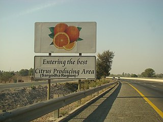
Sargodha District, is a district of Punjab, Pakistan. The capital of the district is Sargodha. It is an agricultural district with wheat, rice, sugarcane and Kinno being its main crops. The Sargodha district and region is also famous for citrus fruit including Kinnow, orange and lemon. The district has an area of 5,864 km2.

Dera Ghazi Khan is a district in the Punjab province of Pakistan. Its capital is the Dera Ghazi Khan city.

Sikhism in Pakistan has an extensive heritage and history, although Sikhs form a small community in Pakistan today. Most Sikhs live in the province of Punjab, a part of the larger Punjab region where the religion originated in the Middle Ages, with some also residing in Peshawar in the Khyber-Pakhtunkhwa province. Nankana Sahib, the birthplace of Guru Nanak, the founder of Sikhism, is located in Pakistan's Punjab province. Moreover, the place where Guru Nanak died, the Gurudwara Kartarpur Sahib is also located in the same province.
Religion in the Punjab in ancient history was characterized by Hinduism and later conversions to Jainism, Buddhism, Islam, Sikhism and Christianity; it also includes folk practices common to all Punjabis regardless of the religion they adhere to. Such practices incorporate local mysticism, including ancestral worship and worship of local saints of all faiths.
Hinduism is a minority religion in Punjab province of Pakistan followed by about 0.2% of its population. Punjab has the second largest number of Hindus in Pakistan after Sindh. Hinduism is followed mainly in the Southern Punjab districts of Rahim Yar Khan and Bahawalpur.

