Cuyahoga Valley National Park is an American national park that preserves and reclaims the rural landscape along the Cuyahoga River between Akron and Cleveland in Northeast Ohio.

The Ellsworth Mountains are the highest mountain ranges in Antarctica, forming a 350 km (217 mi) long and 48 km (30 mi) wide chain of mountains in a north to south configuration on the western margin of the Ronne Ice Shelf in Marie Byrd Land. They are bisected by Minnesota Glacier to form the Sentinel Range to the north and the Heritage Range to the south. The former is by far the higher and more spectacular with Mount Vinson constituting the highest point on the continent. The mountains are located within the Chilean Antarctic territorial claim but outside of the Argentinian and British ones.

Sideling Hill, also Side Long Hill, is a long, steep, narrow mountain ridge in the Ridge-and-Valley physiographic province of the Appalachian Mountains, located in Washington County in western Maryland and adjacent West Virginia and Pennsylvania, USA. The highest point on the ridge is Fisher Point, at 2,310 feet (700 m) in Fulton County, Pennsylvania.
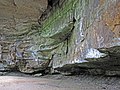
Mary Campbell Cave, also known as Old Maid's Kitchen, is a small secondary rock shelter in Cuyahoga Falls, Ohio. The cliff and cave roof are sandstone of the Sharon Formation, while the cave wall is shale of the Meadville formation. The cavity in the cliff was formed when water passing through the porous sandstone eroded the shale, leaving a ground-level cavity beneath the cliff. The cave is currently part of the Gorge Park, administered by Summit County Metroparks, and is accessible by Gorge Trail. It is located on the north wall of the gorge overlooking the Cuyahoga River. Elevation of floor is approximately 960 feet (290 m) AMSL.

Mary Campbell was an American colonial settler who was known for her abduction by Native Americans during the French and Indian War being the first white child to travel to the Western Reserve. Born in 1747 or 1748, Campbell was taken captive by the Lenape tribe at the age of ten in 1758. It is believed that she lived with the Lenape, possibly under the care of their chief Netawatwees, in locations near Cuyahoga Falls, Ohio, and Newcomerstown, eastern Ohio. Campbell's return to her family in Pennsylvania in 1764 was facilitated by British military pressure on the Native Americans. She was among a group of captives released to British forces and transported to Fort Pitt.

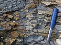
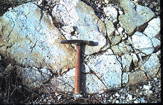
The Silurian Tuscarora Formation — also known as Tuscarora Sandstone or Tuscarora Quartzite — is a mapped bedrock unit in Pennsylvania, Maryland, West Virginia, and Virginia, US.

Bedford County, Pennsylvania is situated along the western border of the Ridge and Valley physiographic province, which is characterized by folded and faulted sedimentary rocks of early to middle Paleozoic age. The northwestern border of the county is approximately at the Allegheny Front, a geological boundary between the Ridge and Valley Province and the Allegheny Plateau.
The Permian Dunkard Group (Pd) is an area of rock, Early Permian in age, in the south of Ohio, southwestern Pennsylvania, West Virginia and the hilltops of the Georges Creek Basin of Maryland. In Ohio, it is found primarily in Washington County. It is notable for being one of the few areas of Permian sediment east of the Mississippi River. In addition, it is the youngest surface rock in the state of Ohio.
The Mississippian Mauch Chunk Formation is a mapped bedrock unit in Pennsylvania, Maryland, and West Virginia. It is named for the township of Mauch Chunk, now known as borough of Jim Thorpe, Pennsylvania and for nearby Mauch Chunk Ridge where the formation crops out.

The Mississippian Pocono Formation is a mapped bedrock unit in Pennsylvania, Maryland, and West Virginia, in the United States. It is also known as the Pocono Group in Maryland and West Virginia, and the upper part of the Pocono Formation is sometimes called the Burgoon Formation or Burgoon Sandstone in Pennsylvania. The Pocono is a major ridge-former In the Ridge-and-Valley Appalachians of the eastern United States

The Pennsylvanian Pottsville Formation is a mapped bedrock unit in Pennsylvania, western Maryland, West Virginia, Ohio, and Alabama. It is a major ridge-former in the Ridge-and-Valley Appalachians of the eastern United States. The Pottsville Formation is conspicuous at many sites along the Allegheny Front, the eastern escarpment of the Allegheny or Appalachian Plateau.

The Marcellus Formation or the Marcellus Shale is a Middle Devonian age unit of sedimentary rock found in eastern North America. Named for a distinctive outcrop near the village of Marcellus, New York, in the United States, it extends throughout much of the Appalachian Basin.
The Devonian Old Port Formation is a mapped bedrock unit in Pennsylvania, USA. Details of the type section and of stratigraphic nomenclature for this unit as used by the U.S. Geological Survey are available on-line at the National Geologic Map Database. Current nomenclature usage by U.S. Geological Survey restricts the name Old Port Formation to Pennsylvania, but correlative units are present in adjacent states.
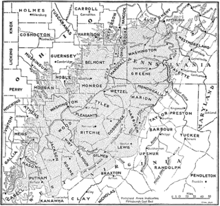
The Pittsburgh Coal Seam is the thickest and most extensive coal bed in the Appalachian Basin; hence, it is the most economically important coal bed in the eastern United States. The Upper Pennsylvanian Pittsburgh coal bed of the Monongahela Group is extensive and continuous, extending over 11,000 mi2 through 53 counties. It extends from Allegany County, Maryland to Belmont County, Ohio and from Allegheny County, Pennsylvania southwest to Putnam County, West Virginia.

The Devonian Foreknobs Formation is a mapped bedrock unit in Pennsylvania, Maryland, Virginia, and West Virginia.

The Glenshaw Formation is a mapped sedimentary bedrock unit in Pennsylvania, Maryland, West Virginia, and Ohio, of Pennsylvanian age. It is the lower of two formations in the Conemaugh Group, the upper being the Casselman Formation. The boundary between these two units is the top of the marine Ames Limestone. The Conemaugh Group overlies the Upper Freeport coal bed of the Allegheny Formation and underlies the Pittsburgh coal seam of the Monongahela Group.
The Gettysburg Formation is a mapped bedrock unit consisting primarily of sandstones, conglomerates, and shales.

The Bluefield Formation is a geologic formation in West Virginia. It preserves fossils dating back to the Mississippian subperiod of the Carboniferous period. Sediments of this age formed along a large marine basin lying in the region of what is now the Appalachian Plateau. The Bluefield Formation is the lowest section of the primarily siliciclastic Mauch Chunk Group, underlying the Stony Gap Sandstone Member of the Hinton Formation and overlying the limestone-rich Greenbrier Group.
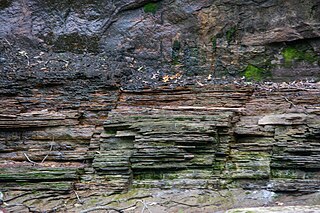
The Cleveland Shale, also referred to as the Cleveland Member, is a shale geologic formation in the eastern United States.
The geology of Ohio formed beginning more than one billion years ago in the Proterozoic eon of the Precambrian. The igneous and metamorphic crystalline basement rock is poorly understood except through deep boreholes and does not outcrop at the surface. The basement rock is divided between the Grenville Province and Superior Province. When the Grenville Province crust collided with Proto-North America, it launched the Grenville orogeny, a major mountain building event. The Grenville mountains eroded, filling in rift basins and Ohio was flooded and periodically exposed as dry land throughout the Paleozoic. In addition to marine carbonates such as limestone and dolomite, large deposits of shale and sandstone formed as subsequent mountain building events such as the Taconic orogeny and Acadian orogeny led to additional sediment deposition. Ohio transitioned to dryland conditions in the Pennsylvanian, forming large coal swamps and the region has been dryland ever since. Until the Pleistocene glaciations erased these features, the landscape was cut with deep stream valleys, which scoured away hundreds of meters of rock leaving little trace of geologic history in the Mesozoic and Cenozoic.