
A canyon, or gorge, is a deep cleft between escarpments or cliffs resulting from weathering and the erosive activity of a river over geologic time scales. Rivers have a natural tendency to cut through underlying surfaces, eventually wearing away rock layers as sediments are removed downstream. A river bed will gradually reach a baseline elevation, which is the same elevation as the body of water into which the river drains. The processes of weathering and erosion will form canyons when the river's headwaters and estuary are at significantly different elevations, particularly through regions where softer rock layers are intermingled with harder layers more resistant to weathering.

A natural arch, natural bridge, or rock arch is a natural landform where an arch has formed with an opening underneath. Natural arches commonly form where inland cliffs, coastal cliffs, fins or stacks are subject to erosion from the sea, rivers or weathering.

The Cuyahoga River is a river in the United States, located in Northeast Ohio, that bisects the City of Cleveland and feeds into Lake Erie.

The Hocking Hills is a deeply dissected area of the Allegheny Plateau in Ohio, primarily in Hocking County, that features cliffs, gorges, rock shelters, and waterfalls. The relatively extreme topography in this area is due to the Blackhand Sandstone, a particular formation that is thick, hard and weather-resistant, and so forms high cliffs and narrow, deep gorges.

Cuyahoga Valley National Park is an American national park that preserves and reclaims the rural landscape along the Cuyahoga River between Akron and Cleveland in Northeast Ohio.

The mayor of Cleveland is the head of the executive branch of government of the City of Cleveland, Ohio. As the chief executive in Cleveland's mayor–council system, the mayor oversees all city services and is "responsible for enforcing the city charter, city ordinances, and the laws of the State of Ohio." The mayor's office is located at Cleveland City Hall at 601 Lakeside Avenue in Downtown Cleveland. Since 1836, the city has had a total of 54 mayors, including the city's current mayor, Justin Bibb, encompassing 58 mayoral administrations, as four mayors have served in non-consecutive terms.
Tinker's Creek, in Cuyahoga, Summit and Portage counties, is the largest tributary of the Cuyahoga River, providing about a third of its flow into Lake Erie.
Summit Metro Parks is a Metroparks system serving the citizens of Summit County, Ohio by managing 14,000 acres (5,700 ha) in 16 developed parks, six conservation areas and more than 150 miles (240 km) of trails, with 22.4 miles (36.0 km) of the Ohio & Erie Canal Towpath Trail.

Mary Campbell was an American colonial settler, taken captive as a child by Native Americans during the French and Indian War. Later rescued, she is believed to have been the first white child to travel to the Western Reserve.
Kanger Ghati National Park was declared a national park in 1982 by the Government of India. Near Jagdalpur in the Bastar region of Chhattisgarh, it is one of India's densest national parks, and is known for its biodiversity, landscape, waterfalls, and subterranean geomorphologic limestone caves, and as the home of the Bastar hill myna, the state bird of Chhattisgarh.

The Cuyahoga County Soldiers' and Sailors' Monument is a major Civil War monument in Cleveland, Ohio, honoring the more than 9,000 individuals from Cuyahoga County who served the Union throughout the war. It was dedicated on July 4, 1894, and is located on the southeast quadrant of Public Square in Downtown Cleveland. It was designed by architect and Civil War veteran Levi Scofield, who also created the monument's sculptures. The monument is regularly open to the public, free of charge.

The Linville Gorge Wilderness is the third largest wilderness area in North Carolina and one of only two wilderness gorges in the Southern United States. Maintained by the United States Forest Service, it comprises 11,786 acres (47.7 km2) around the Linville River, and is situated inside the Pisgah National Forest. The river is approximately 1,400 feet below the ridge, thus hiking in and out of the Gorge is challenging and enjoyable for those who like serious hiking. The plant and animal community is extremely diverse, with a dense hardwood/pine forest and a wide variety of smaller trees and other plants as well as bear, fox, raccoon, trout, grouse, wild turkey, vultures, owls, hawks, copperheads, and timber rattlesnakes.

Brandywine Creek is a tributary of the Cuyahoga River that is partly contained in Cuyahoga Valley National Park in Ohio.

The Surprise Canyon Formation is a geologic formation that consists of clastic and calcareous sedimentary rocks that fill paleovalleys and paleokarst of Late Mississippian (Serpukhovian) age in Grand Canyon. These strata outcrop as isolated, lens-shaped exposures of rocks that fill erosional valleys and locally karsted topography and caves developed in the top of the Redwall Limestone. The Surprise Canyon Formation and associated unconformities represent a significant period of geologic time between the deposition of the Redwall Limestone and the overlying Supai Group.
This is a list of high school athletic conferences in the Northeast Region of Ohio, as defined by the OHSAA. Because the names of localities and their corresponding high schools do not always match and because there is often a possibility of ambiguity with respect to either the name of a locality or the name of a high school, the following table gives both in every case, with the locality name first, in plain type, and the high school name second in boldface type. The school's team nickname is given last.
Western Reserve Hospital is a hospital in Cuyahoga Falls, Ohio, and it is the only physician-owned hospital in Northeast Ohio. Western Reserve Hospital's stated mission is to be "all about the patient," and the hospital has won a number of awards and accreditation for patient care and its commitment to the Northeast Ohio community.
The geology of Ohio formed beginning more than one billion years ago in the Proterozoic eon of the Precambrian. The igneous and metamorphic crystalline basement rock is poorly understood except through deep boreholes and does not outcrop at the surface. The basement rock is divided between the Grenville Province and Superior Province. When the Grenville Province crust collided with Proto-North America, it launched the Grenville orogeny, a major mountain building event. The Grenville mountains eroded, filling in rift basins and Ohio was flooded and periodically exposed as dry land throughout the Paleozoic. In addition to marine carbonates such as limestone and dolomite, large deposits of shale and sandstone formed as subsequent mountain building events such as the Taconic orogeny and Acadian orogeny led to additional sediment deposition. Ohio transitioned to dryland conditions in the Pennsylvanian, forming large coal swamps and the region has been dryland ever since. Until the Pleistocene glaciations erased these features, the landscape was cut with deep stream valleys, which scoured away hundreds of meters of rock leaving little trace of geologic history in the Mesozoic and Cenozoic.
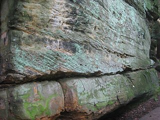
The Sharon Conglomerate is a geologic formation of early Pennsylvanian age in Pennsylvania, Ohio, and Maryland, in the United States. It is dominantly conglomerate and quartzarenite sandstone. In places it is abundantly crossbedded.

