The United States Army Corps of Engineers (USACE) is an engineer formation of the United States Army that has three primary mission areas: Engineer Regiment, military construction, and civil works. The day-to-day activities of the three mission areas are administered by a lieutenant general known as the commanding general/chief of engineers. The chief of engineers commands the Engineer Regiment, comprising combat engineer, rescue, construction, dive, and other specialty units, and answers directly to the Chief of Staff of the Army. Combat engineers, sometimes called sappers, form an integral part of the Army's combined arms team and are found in all Army service components: Regular Army, National Guard, and Army Reserve. Their duties are to breach obstacles; construct fighting positions, fixed/floating bridges, and obstacles and defensive positions; place and detonate explosives; conduct route clearance operations; emplace and detect landmines; and fight as provisional infantry when required. For the military construction mission, the commanding general is directed and supervised by the Assistant Secretary of the Army for installations, environment, and energy, whom the President appoints and the Senate confirms. Military construction relates to construction on military bases and worldwide installations.

Aberdeen Proving Ground (APG) is a U.S. Army facility located adjacent to Aberdeen, Harford County, Maryland, United States. More than 7,500 civilians and 5,000 military personnel work at APG. There are 11 major commands among the tenant units, including:

Wright-Patterson Air Force Base (WPAFB) is a United States Air Force base and census-designated place just east of Dayton, Ohio, in Greene and Montgomery counties. It includes both Wright and Patterson Fields, which were originally Wilbur Wright Field and Fairfield Aviation General Supply Depot. Patterson Field is approximately 16 kilometres (10 mi) northeast of Dayton; Wright Field is approximately 8.0 kilometres (5 mi) northeast of Dayton.
The Mississippi River–Gulf Outlet Canal is a 76 mi (122 km) channel constructed by the United States Army Corps of Engineers at the direction of Congress in the mid-20th century that provided a shorter route between the Gulf of Mexico and New Orleans' inner harbor Industrial Canal via the Intracoastal Waterway. In 2005, the MRGO channeled Hurricane Katrina's storm surge into the heart of Greater New Orleans, contributing significantly to the subsequent multiple engineering failures experienced by the region's hurricane protection network. In the aftermath the channel was closed. A permanent storm surge barrier was constructed in the MRGO in 2009, and the channel has been closed to maritime shipping.

Camp Leach, formerly known as the American University Experimental Station and Camp American University, was a World War I era United States Army camp built by the Corps of Engineers on American University property in Washington, D.C. It was named in honor of Colonel Smith S. Leach, Corps of Engineers. The camp was established in 1917 for the organization of engineer units and subsequently used by the Chemical Warfare Service. Abandoned in January 1919, it was ordered salvaged.
Dalecarlia Reservoir is the primary storage basin for drinking water in Washington, D.C., and Arlington County, Virginia. The reservoir is fed by an underground aqueduct in turn fed by low dams which divert portions of the Potomac River near Great Falls and Little Falls. The reservoir is located between Spring Valley and the Palisades, two neighborhoods in Northwest Washington, D.C., and Brookmont, a neighborhood in Montgomery County, Maryland.

The Scioto Ordnance Plant (SOP) was a munitions and incendiary bomb-making facility built in Marion County, Ohio, by the United States Army in 1942, and operated under lease by United States Rubber Company – most recently known as Uniroyal. The plant operated until 1945, when production wound down. Also built adjacent was the Marion Engineering Depot which was authorized in the summer of 1942. Land for the plant was taken in Grand Prairie, Scott, Clairdon and Marion Townships in an area covering 12,500 acres (51 km2).

The Stratford Army Engine Plant (SAEP) was a U.S. Army Tank-Automotive and Armaments Command installation and manufacturing facility located in Stratford, Connecticut, where it was sited along the Housatonic River and Main Street, opposite Sikorsky Memorial Airport.

The former Lake Ontario Ordnance Works (LOOW) was a 7,500-acre (3,000 ha) military installation located in Niagara County, New York, United States, approximately 9.6 mi (15.4 km) north of Niagara Falls.
Soil vapor extraction (SVE) is a physical treatment process for in situ remediation of volatile contaminants in vadose zone (unsaturated) soils. SVE is based on mass transfer of contaminant from the solid (sorbed) and liquid phases into the gas phase, with subsequent collection of the gas phase contamination at extraction wells. Extracted contaminant mass in the gas phase is treated in aboveground systems. In essence, SVE is the vadose zone equivalent of the pump-and-treat technology for groundwater remediation. SVE is particularly amenable to contaminants with higher Henry’s Law constants, including various chlorinated solvents and hydrocarbons. SVE is a well-demonstrated, mature remediation technology and has been identified by the U.S. Environmental Protection Agency (EPA) as presumptive remedy.
The Denver Federal Center, in Lakewood, Colorado, is part of the General Services Administration and is home to about 6,200 employees of agencies of the federal government of the United States. The Center encompasses an area of about 670 acres (2.7 km2) and has 90 buildings with over 4,000,000 square feet (400,000 m2) of office, warehouse, lab and special use space. There are 28 different Federal agencies on-site, making it the largest concentration of Federal agencies outside of Washington, D.C.
The Formerly Utilized Sites Remedial Action Program (FUSRAP) is a United States Army Corps of Engineers (USACE) project to manage and cleanup environmental contamination that resulted from early United States Atomic Energy Commission activities. Cleanup activities were initially performed under the supervision of the United States Department of Energy (DOE), until 1997 when the United States Congress passed authority for cleanup activities to the USACE.
Rivers and Harbors Act may refer to one of many pieces of legislation and appropriations passed by the United States Congress since the first such legislation in 1824. At that time Congress appropriated $75,000 to improve navigation on the Ohio and Mississippi rivers by removing sandbars, snags, and other obstacles. Like when first passed, the legislation was to be administered by the United States Army Corps of Engineers (USACE), under its Chief Engineer and the Secretary of War.

Tully Lake, of Royalston, Massachusetts, is a 1,262-acre (511 ha) reservoir and flood control project constructed by the United States Army Corps of Engineers (USACE) in 1949 for 1.6 million dollars. The project prevents flooding of the greater Connecticut River and Millers River valleys and provides a variety of recreational opportunities, including a campground operated by The Trustees of Reservations. Tully Lake is an important link in the 22-mile (35 km) Tully Trail.
Red Bluff Air Force Station is a closed United States Air Force General Surveillance Radar station. It is located 4.3 miles (6.9 km) west-southwest of Red Bluff, California. It was closed in 1970.

The Fairfield Aviation General Supply Depot is a former Aviation Section, U.S. Signal Corps military facility, located adjacent to Wilbur Wright Field in Riverside, Ohio.
The Potomac River basin reservoir projects were U.S. Army Corps of Engineers programs that sought to regulate the flow of the Potomac River to control flooding, to assure a reliable water supply for Washington, D.C., and to provide recreational opportunities. Beginning in 1921 the Corps studied a variety of proposals for an ambitious program of dam construction on the Potomac and its tributaries, which proposed as many as sixteen major dam and reservoir projects. The most ambitious proposals would have created a nearly continuous chain of reservoirs from tidewater to Cumberland, Maryland. The 1938 program was focused on flood control, on the heels of a major flood in 1936. The reformulated 1963 program focused on water supply and quality, mitigating upstream pollution from sewage and coal mine waste.
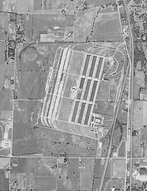
The Nebraska Ordnance Plant is a former United States Army ammunition plant located approximately ½ mile south of Mead, Nebraska and 30 miles west of Omaha, Nebraska in Saunders County. It originally extended across 17,250 acres (69.8 km2) producing weapons from 1942-45 after which the Army used it as a bomb factory during the Vietnam War. Environmental investigations in the 1980's found the soil and groundwater contaminated with the explosive RDX and the degreaser trichloroethylene. In 1990, federal agencies added the site to the National Priorities List as a Superfund site. Remediation included soil excavation and water treatment, the latter of which has been ongoing since 1997. Water is contained and treated at 4 treatment plants and the known plumes are monitored at hundreds of wells. The latest wells, dug deeper into the bedrock than previously, showed RDX and TCE above desired action levels in April 2016.

Margaret Williams Burcham is a retired brigadier general of the United States Army. She was the first female brigadier general in the United States Army Corps of Engineers.