
The South Luzon Expressway (SLEX), signed as E2 of the Philippine expressway network and R-3 of the Metro Manila arterial road network, is a limited-access toll expressway that connects Metro Manila to the provinces in the Calabarzon region on the island of Luzon in the Philippines. The expressway has a length of 49.56 km, traveling from its northern terminus at the Magallanes Interchange in Makati to its southern terminus at Santo Tomas, Batangas, connecting it to the Southern Tagalog Arterial Road. A portion of the expressway from the Magallanes Interchange to the Calamba Exit is part of Asian Highway 26 of the Asian highway network.

The expressway network of China, with the national-level expressway system officially known as the National Trunk Highway System, is an integrated system of national and provincial-level expressways in China.

A limited-access road, known by various terms worldwide, including limited-access highway, dual-carriageway, expressway, and partial controlled-access highway, is a highway or arterial road for high-speed traffic which has many or most characteristics of a controlled-access highway, including limited or no access to adjacent property, some degree of separation of opposing traffic flow, use of grade separated interchanges to some extent, prohibition of slow modes of transport, such as bicycles, (draught) horses, or self-propelled agricultural machines; and very few or no intersecting cross-streets or level crossings. The degree of isolation from local traffic allowed varies between countries and regions. The precise definition of these terms varies by jurisdiction.

The expressways of Japan make up a large network of controlled-access toll expressways.

The Mumbai–Pune Expressway is India's first 6-lane wide concrete, access-controlled tolled expressway. It spans a distance of 94.5 km connecting Mumbai, the capital of Maharashtra state and the financial capital of India, with Pune, the cultural and educational capital of Maharashtra. The expressway, which was fully operationalized in 2002, introduced new levels of speed and safety in automobile transportation to Indian roads. It is one of India's busiest roads.

A controlled-access highway is a type of highway that has been designed for high-speed vehicular traffic, with all traffic flow—ingress and egress—regulated. Common English terms are freeway, motorway and expressway. Other similar terms include throughway and parkway. Some of these may be limited-access highways, although this term can also refer to a class of highways with somewhat less isolation from other traffic.

Roads are an important mode of transport in India. India has a network of over 6,215,797 kilometres (3,862,317 mi) of roads as of 1 December 2021. This is the second-largest road network in the world, after the United States. At of roads per square kilometre of land, the quantitative density of India's road network is equal to that of Hong Kong, and substantially higher than the United States, China, Brazil and Russia. Adjusted for its large population, India has approximately 5.13 kilometres (3.19 mi) of roads per 1,000 people, which is much lower than United States 20.5 kilometres (12.7 mi) but higher than that of China 3.6 kilometres (2.2 mi). India's road network carries over 71 percent of its freight and about 85 percent of passenger traffic.
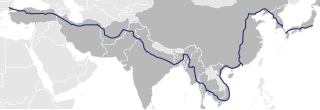
Asian Highway 1 (AH1) is the longest route of the Asian Highway Network, running 20,557 km (12,774 mi) from Tokyo, Japan via Korea, China, Southeast Asia, Bangladesh, India, Pakistan, Afghanistan and Iran to the border between Turkey and Bulgaria west of Istanbul where it joins end-on with European route E80, running all the way to Lisbon, Portugal.
The Western Peripheral Expressway (WPE) or Kundli–Manesar–Palwal Expressway, is an operational 6-lane, 135.6 km (84.3 mi)-long Expressway in the Haryana state of India. Along with the Eastern Peripheral Expressway, the Western Peripheral Expressway is expected to divert more than 50,000 heavy vehicles away from Delhi, which will help to maintain good air quality in Delhi. Western Peripheral Expressway along with Eastern Peripheral Expressway completes the largest Ring Road around Delhi. There are 10 tolled entries and exits, from north to south - Kundli, Kharkhoda, Bahadurgarh, Badli, Fartukhnagar, Panchgaon, Manesar, Taoru, Sohna & Palwal. Toll rate notified in December 2018 is INR1.35 per km for cars, INR2.18 per km for light motor vehicles, INR4.98 per km for trucks and buses, and two wheelers are not permitted on the expressway.

The Asahikawa-Monbetsu Expressway is an incomplete national expressway in Hokkaido connecting Asahikawa, Hokkaidō and Monbetsu, Hokkaidō for a total length of 130 km. It is owned and operated by the Ministry of Land, Infrastructure, Transport and Tourism (MLIT). The route is signed E39 under MLIT's "2016 Proposal for Realization of Expressway Numbering" and also as National Route 450.

Yamuna Expressway is a 6-lane wide and 165.5 km long access-controlled expressway in the Indian state of Uttar Pradesh. It is presently India's 6th longest expressway. It was built to de-congest the older Delhi–Agra national highway (NH-2) or Mathura Road.

Expressways are the highest class of roads in India. As of July 2023, India has a total length of 4,719 km (2,932 mi) of expressways. These are controlled-access highways where entrance and exits are controlled by the use of cloverleaf or trumpet or grade separated interchanges that are incorporated into the design of the expressway and designed for maximum speed of 120 km/h, whereas National highways are flyover access or controlled-access highway, where entrance and exit is through the side of the flyover, at each intersection of highway with road, flyovers are provided to bypass the city/town/village traffic and these highways are designed for speed of 100 km/h. Some roads are not access-controlled expressways, but are still named as expressways, such as the Biju Expressway, these are actually state highways which are not declared by central government as an Expressway, hence not an Expressway or National Highway. Mumbai–Pune Expressway is the first 6-lane operational expressway in India started in 2002. Expressways follow standards set by Indian Roads Congress and Bureau of Indian Standards.
Belghoria Expressway is a four-lane 16 kilometres (9.9 mi) long grade separated tolled expressway in the North Suburban fringes of Kolkata, West Bengal. It is a key arterial road, linking the terminal junction points of NH 16 and NH 19 at Rajchandrapur to Dakshineswar across Nivedita Setu and then to NH 12 at Dumdum/Kolkata Airport.

The Malaysian Expressway System is a network of national controlled-access expressways in Malaysia that forms the primary backbone network of Malaysian national highways. The network begins with the Tanjung Malim–Slim River tolled road which was opened to traffic on 16 March 1966, later North–South Expressway (NSE), and is being substantially developed. Malaysian expressways are built by private companies under the supervision of the government highway authority, Malaysian Highway Authority.
Northern Peripheral Road or NH 248-BB, commonly known as Dwarka Expressway is a 27.6 km (17.1 mi) long, under construction, 8-lane, elevated grade separated expressway connecting Dwarka in Delhi to Kherki Daula Toll Plaza, Gurgaon in Haryana. The expressway will take off from km 20 of NH 48 at Shiv Murti in Mahipalpur in Delhi and terminate at km 40 of NH 48 near Kherki Daula Toll Plaza in Gurgaon in Haryana. The NPR has been planned as an alternate road link between Delhi and Gurgaon, and is expected to ease the traffic situation on the Delhi-Gurgaon Expressway. The expressway was initially planned to be 18 km (11 mi) long and was expected to open by 2012 but land acquisition issues delayed the project.

The Agra–Lucknow Expressway is a 302 km long, 6-lane wide access-controlled expressway constructed by the Uttar Pradesh Expressways Industrial Development Authority (UPEIDA) to reduce traffic in already congested roads and to reduce pollution and carbon footprint. The expressway reduced the distance between the cities of Agra and Lucknow in the Indian state of Uttar Pradesh and is presently one of the India's longest operational expressway.

Delhi–Meerut Expressway or National Expressway 3 is India's widest 96 km long controlled-access expressway, connecting Delhi with Meerut via Dasna in Ghaziabad in India. The 8 lanes old stretch of National Highway 9 (NH-9) up to Dasna is widened to 14 lanes. The fourth phase of the expressway is built on a new alignment from Dasna to Meerut – a six-lane stretch joining Meerut bypass. The 28 km (17 mi) stretch between Nizamuddin Bridge and Dasna is one of the most congested areas in the NCR. The total project cost is estimated to be between ₹8,000–10,000 crores.
Purvanchal Expressway is a 340.8 km long, 6-lane wide access-controlled expressway in the state of Uttar Pradesh, India. The expressway connects Chand Saray village near Gosainganj in Lucknow district with Haydaria village on NH-31 in Ghazipur district. It is developed by the Uttar Pradesh Expressways Industrial Development Authority (UPEIDA). The Purvanchal Expressway has a 3.2 km long airstrip at Akhalkiri Karwat village near Kurebhar in Sultanpur district for emergency landing of aircraft. The construction work was started by the UPEIDA on 10 October 2018 and was inaugurated and opened to the public on 16 November 2021.
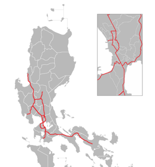
The Philippine expressway network, also known as the High Standard Highway Network, is a controlled-access highway network managed by the Department of Public Works and Highways (DPWH) which consists of all expressways and regional high standard highways in the Philippines.
The Delhi–Mumbai Expressway is a 1,350 km long, 8-lane wide under-construction access-controlled expressway connecting India's national capital New Delhi with its financial capital Mumbai. Foundation stone of the project was laid by union minister Nitin Gadkari in presence of Sushma Swaraj and Arun Jaitley on 8 March 2019. The total project value including the land acquisition cost is around ₹1,00,000 crores. An additional 31 km long spur will also be constructed by the NHAI from Noida International Airport in Jewar to Sector-65, Faridabad on this expressway.


