Silverthorne, Colorado

Last updated

Silverthorne, Colorado
2011-07-07 10.18.17.jpg
Silverthorne seen from Ptarmigan Peak. In the background Buffalo Mountain is on the left, while Red Mountain and Mount Silverthorne are located adjacent to each other to the right.
Silverthorne, Colorado logo.svg
Summit County Colorado Incorporated and Unincorporated areas Silverthorne Highlighted 0870525.svg
Location of Silverthorne in Summit County, Colorado.
Coordinates: 39°38′18″N106°4′35″W / 39.63833°N 106.07639°W / 39.63833; -106.07639
Country Flag of the United States (23px).png  United States
State Flag of Colorado.svg  Colorado
County [1] Summit County
Incorporated September 5, 1967 [2]
Government
  Type Home rule municipality [1]
Area
[3]
  Total4.07 sq mi (10.54 km2)
  Land4.00 sq mi (10.37 km2)
  Water0.07 sq mi (0.17 km2)
Elevation
[4]
8,790 ft (2,680 m)
Population
 (2020) [5]
  Total4,402
  Density1,100/sq mi (420/km2)
Time zone UTC-7 (Mountain (MST))
  Summer (DST) UTC-6 (MDT)
ZIP codes [6]
80497 (Post-office box), 80498
Area code 970
FIPS code 08-70525
GNIS feature ID2413288 [4]
Website Town of Silverthorne

The Town of Silverthorne is a home rule municipality in Summit County, Colorado. According to the 2020 Census, the population of the city is 4,402. [5]

Contents

History

The town was named for Judge Marshall Silverthorn who served as the judge of the miners' court in Breckenridge. The judge first came to town as a prospector and claimed a section of the Blue River in 1881. After patenting his claim in April 1882, he was disappointed to find the gold to be sparse and the claim a poor bet. The land passed to his daughters on his death in 1887 and was then sold several times to various mining companies. In 1953 Clayton Hill bought the property and subdivided it for homes and stores. [7]

Silverthorne served as a makeshift camp for workers during the construction of the Dillon Reservoir from 1961 to 1963, and later as a stop along Interstate 70. It was eventually incorporated on April 5, 1967. [2]

The city has expanded several times since incorporation by annexation.

Since 2016, the town of Silverthorne has hosted the Silverthon Games, an annual competition featuring a seasonally-based slate of individual and team events, culminating with the heavily spectated Hummingbird Circle race. [8]

Geography

Silverthorne is situated between the Gore Range to the west and the Continental Divide to the east. The two most visible mountains are Buffalo and Red Mountains. Also surrounding the valley are Ptarmigan, Tenderfoot, and Ten Mile Peaks.

According to the United States Census Bureau, the town has a total area of 3.2 square miles (8.3 km2), of which, 3.2 square miles (8.3 km2) of it is land and 0.04 square miles (0.10 km2) of it (0.94%) is water.

Climate

Silverthorne has a highland-influenced subpolar climate (Köppen (Dfc) with warm summer days, cold nights year round, as well as cold and snowy winter days.

Climate data for Silverthorne (1981–2010, extremes 1910-2018)
MonthJanFebMarAprMayJunJulAugSepOctNovDecYear
Record high °F (°C)61
(16)
60
(16)
63
(17)
76
(24)
80
(27)
87
(31)
89
(32)
87
(31)
84
(29)
77
(25)
65
(18)
61
(16)
89
(32)
Mean daily maximum °F (°C)31.7
(−0.2)
33.9
(1.1)
39.6
(4.2)
47.3
(8.5)
57.3
(14.1)
67.9
(19.9)
74.0
(23.3)
71.9
(22.2)
64.9
(18.3)
53.5
(11.9)
40.2
(4.6)
31.5
(−0.3)
51.1
(10.6)
Mean daily minimum °F (°C)1.8
(−16.8)
4.0
(−15.6)
11.7
(−11.3)
18.8
(−7.3)
27.3
(−2.6)
33.7
(0.9)
39.0
(3.9)
38.2
(3.4)
30.7
(−0.7)
22.0
(−5.6)
12.6
(−10.8)
3.8
(−15.7)
20.3
(−6.5)
Record low °F (°C)−44
(−42)
−45
(−43)
−38
(−39)
−25
(−32)
−8
(−22)
11
(−12)
22
(−6)
20
(−7)
4
(−16)
−17
(−27)
−30
(−34)
−46
(−43)
−46
(−43)
Average precipitation inches (mm)0.81
(21)
0.92
(23)
1.01
(26)
1.26
(32)
1.31
(33)
1.25
(32)
1.95
(50)
1.93
(49)
1.42
(36)
0.90
(23)
0.93
(24)
0.86
(22)
14.55
(371)
Average snowfall inches (cm)14.7
(37)
15.7
(40)
16.5
(42)
15.8
(40)
5.6
(14)
0.7
(1.8)
0
(0)
0
(0)
1.4
(3.6)
6.6
(17)
14.1
(36)
15.0
(38)
106.1
(269.4)
Average precipitation days (≥ 0.04 in)6.76.57.57.97.26.49.110.27.55.96.76.688.2
Average snowy days (≥ 0.4 in)9.58.79.48.53.30.4000.73.78.18.961.2
Source: NWS NOWDATA —data from Dillon 1E 1981-2010

Demographics

Historical population
CensusPop.Note
1970 400
1980 989147.3%
1990 1,76878.8%
2000 3,19680.8%
2010 3,88721.6%
2020 4,40213.2%

Notable people

Notable individuals who were born in or have lived in Silverthorne include:

See also

Related Research Articles

<span class="mw-page-title-main">Daggett County, Utah</span> County in Utah, United States

Daggett County is a county in the northeastern corner of the U.S. state of Utah. As of the 2020 United States Census, the population was 935, making it the least populous county in Utah. Its county seat is Manila. The county was named for Ellsworth Daggett, the first surveyor-general of Utah. The small community of Dutch John, located near the state line with Colorado and Wyoming, became an incorporated town in January 2016.

<span class="mw-page-title-main">Beaverhead County, Montana</span> County in Montana, United States

Beaverhead County is the largest county by area in the U.S. state of Montana. As of the 2020 census, the population was 9,371. Its county seat is Dillon. The county was founded in 1865.

<span class="mw-page-title-main">Summit County, Colorado</span> County in Colorado, United States

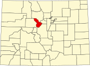
Summit County is a county located in the U.S. state of Colorado. As of the 2020 census, the population was 31,055. The county seat and largest town is Breckenridge.

<span class="mw-page-title-main">Grand County, Colorado</span> County in Colorado, United States

Grand County is a county located in the U.S. state of Colorado. As of the 2020 census, the population was 15,717. The county seat is Hot Sulphur Springs.

<span class="mw-page-title-main">Brighton, Colorado</span> City in Colorado, United States

Brighton is a home rule municipality city located in Adams and Weld counties, Colorado, United States. Brighton is the county seat of Adams County and a part of the Denver–Aurora–Lakewood, CO Metropolitan Statistical Area and the Front Range Urban Corridor. The city population was 40,083 at the 2020 United States Census with 39,718 residing in Adams County and 365 residing in Weld County.

<span class="mw-page-title-main">Two Buttes, Colorado</span> Town in Colorado, United States

Two Buttes is a Statutory Town located in Baca County, Colorado, United States. The population was 34 at the 2020 census.

<span class="mw-page-title-main">Timnath, Colorado</span> Town in Colorado, United States

The Town of Timnath is a Statutory Town located in Larimer County, Colorado, United States. Founded in 1882, Timnath is a small agricultural/farming community located southeast of Fort Collins, Colorado, approximately one-half mile east of the Harmony Road/Interstate 25 interchange, on a small bluff east of the Cache la Poudre River. The surrounding farmlands have been used primarily for potatoes, alfalfa, sugar beets, and cattle. Although the town has remained virtually unchanged in recent decades, the encroaching growth of both Fort Collins to the west and Windsor to the south have placed the town in an area considered favorable to development. The population was 6,487 at the 2020 census. Timnath has been one of the fastest-growing communities in Colorado since 2020, and in 2022 had an estimated population of 9,344.

<span class="mw-page-title-main">Windsor, Colorado</span> Town in Colorado, United States

Windsor is a home rule municipality in Larimer and Weld counties in the U.S. state of Colorado. According to the 2020 census, the population of the town was 32,716. Windsor is located in the Northern Colorado region.

<span class="mw-page-title-main">Dolores, Colorado</span> Town in Montezuma County, Colorado, United States

Dolores is a Statutory Town located in Montezuma County, Colorado, United States. The town population was 885 at the 2020 United States Census.

<span class="mw-page-title-main">Rocky Ford, Colorado</span> City in Otero County, Colorado, United States

Rocky Ford is a statutory city located in Otero County, Colorado, United States. The population was 3,876 at the 2020 census.

<span class="mw-page-title-main">Dillon, Colorado</span> Town in Colorado, United States

The Town of Dillon is a home rule municipality located in Summit County, Colorado, United States. The town population was 1,064 at the 2020 United States Census, a +17.70% increase since the 2010 United States Census. Dillon is a part of the Breckenridge, CO Micropolitan Statistical Area.

<span class="mw-page-title-main">Frisco, Colorado</span> Town in Colorado, United States

Frisco is a home rule municipality located in Summit County, Colorado, United States. The population was 2,913 at the 2020 census. Frisco is a part of the Breckenridge, CO Micropolitan Statistical Area. It is a popular town among skiers from around the world. Four major ski resorts are located in close proximity to Frisco: Copper Mountain, Breckenridge, Keystone, and Arapahoe Basin.

<span class="mw-page-title-main">Keystone, Colorado</span> Home rule municipality in Colorado, United States

Keystone is a home rule town and a census-designated place (CDP) located in and governed by Summit County, Colorado, United States. The CDP is a part of the Breckenridge, CO Micropolitan Statistical Area. The population of the Keystone CDP was 1,369 at the United States Census 2020. The Dillon post office (Zip Code 80435) serves Keystone postal addresses. The Keystone CDP includes the Keystone Resort and Keystone village. Keystone residents voted to incorporate in March 2023.

<span class="mw-page-title-main">Platteville, Colorado</span> Town in Colorado, United States

Platteville is a Statutory Town in Weld County, Colorado, United States. The population was 2,955 at the 2020 census. It is adjacent to Fort Vasquez on U.S. Highway 85.

<span class="mw-page-title-main">Colebrook, Connecticut</span> Town in Connecticut, United States

Colebrook is a town in Litchfield County, Connecticut, United States. The population was 1,361 at the 2020 census. The town is part of the Northwest Hills Planning Region. Colebrook was named after Colebrooke in the English county of Devon; the reason is now unknown.

<span class="mw-page-title-main">Pelham, Massachusetts</span> Town in Massachusetts, United States

Pelham is a town in Hampshire County, Massachusetts, United States. The population was 1,280 at the 2020 census. Its ZIP Code is shared with Amherst.

<span class="mw-page-title-main">Dillon Reservoir</span> Fresh water reservoir in Summit County, Col., US

Dillon Reservoir, sometimes referred to as Lake Dillon, is a large fresh water reservoir located in Summit County, Colorado, United States, south of I-70 and bordered by the towns of Frisco, Silverthorne, and Dillon. It is a reservoir for the city of Denver, and its waters are under the control of Denver Water. Popular ski areas are close to the reservoir, including Copper Mountain, Keystone, Arapahoe Basin, and Breckenridge.

<span class="mw-page-title-main">Littleton, Colorado</span> City in Colorado, United States

Littleton is a home rule municipality city located in Arapahoe, Douglas, and Jefferson counties, Colorado, United States. Littleton is the county seat of Arapahoe County and is a part of the Denver–Aurora–Lakewood, CO Metropolitan Statistical Area. The city population was 45,652 at the 2020 United States Census, ranking as the 20th most populous municipality in the State of Colorado.

<span class="mw-page-title-main">Silverthorne Micropolitan Statistical Area</span>

The Silverthorne Micropolitan Statistical Area is a United States Census Bureau defined Micropolitan Statistical Area located in the Silverthorne area of the State of Colorado. The Silverthorne Micropolitan Statistical Area is defined as Summit County, Colorado. The Micropolitan Statistical Area had a population of 23,548 at the 2000 Census. A July 1, 2009 U.S. Census Bureau estimate placed the population at 27,239.

<span class="mw-page-title-main">Norrie, Colorado</span> Unincorporated community in Pitkin County, Colorado, United States

Norrie is a census-designated place (CDP) located in and governed by Pitkin County, Colorado, United States. The population of the Norrie CDP was 7 at the United States Census 2020. The Meredith post office (Zip Code 81642) serves the area. The CDP is a part of the Glenwood Springs, CO Micropolitan Statistical Area.

References

  1. 1 2 "Active Colorado Municipalities". State of Colorado, Department of Local Affairs. Archived from the original on December 12, 2009. Retrieved September 1, 2007.
  2. 1 2 "Colorado Municipal Incorporations". State of Colorado, Department of Personnel & Administration, Colorado State Archives. December 1, 2004. Retrieved September 2, 2007.
  3. "2019 U.S. Gazetteer Files". United States Census Bureau. Retrieved July 1, 2020.
  4. 1 2 U.S. Geological Survey Geographic Names Information System: Silverthorne, Colorado
  5. 1 2 United States Census Bureau. "Silverthorne town; Colorado" . Retrieved April 20, 2023.
  6. "ZIP Code Lookup" (JavaScript/HTML). United States Postal Service . Retrieved January 2, 2008.
  7. <
  8. "Silverthon Historic Results". Silverthon Results. Retrieved February 12, 2019.
  9. Gerard, Tieghan (April 24, 2022). "Nine Favorite Things". Half Baked Harvest. Retrieved October 31, 2023.
  10. Gerard, Tieghan (September 15, 2016). "Skinny Cajun Sweet Potato Fries with Garlic Cheese Sauce". Half Baked Harvest. Retrieved October 31, 2023.
  11. Moskin, Julia (October 30, 2023). "The Star of Half Baked Harvest Inspires Loyalty — and Controversy". The New York Times. Retrieved October 31, 2023.
  12. "Dan Gibbs' Biography". Vote Smart. Retrieved June 17, 2016.
  13. "Mike Potekhen". ChampCarStats.com. Archived from the original on March 3, 2016. Retrieved June 17, 2016.