
Lake Michigan is one of the five Great Lakes of North America. It is the second-largest of the Great Lakes by volume and the third-largest by surface area, after Lake Superior and Lake Huron. To the east, its basin is conjoined with that of Lake Huron through the 3+1⁄2-mile (5.6-kilometer) wide, 295-foot deep Straits of Mackinac, giving it the same surface elevation as its easterly counterpart; the two are geologically a single lake.

Mackinac Island is an island and resort area, covering 4.35 square miles (11.3 km2) in land area, in the U.S. state of Michigan. The name of the island in Odawa is Michilimackinac and "Mitchimakinak" in Ojibwemowin meaning "Great Turtle". It is located in Lake Huron, at the eastern end of the Straits of Mackinac, between the state's Upper and Lower Peninsulas. The island was long home to an Odawa settlement and previous indigenous cultures before European colonization began in the 17th century. It was a strategic center of the fur trade around the Great Lakes. Based on a former trading post, Fort Mackinac was constructed on the island by the British during the American Revolutionary War. It was the site of two battles during the War of 1812 before the northern border was settled and the US gained this island in its territory.

Mackinac County is a county in the Upper Peninsula of the U.S. state of Michigan. As of the 2020 census, the population was 10,834. The county seat is St. Ignace. Formerly known as Michilimackinac County, in 1818 it was one of the first counties of the Michigan Territory, as it had long been a center of French and British colonial fur trading, a Catholic church and Protestant mission, and associated settlement.
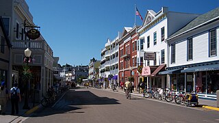
Mackinac Island is a city in Mackinac County in the U.S. state of Michigan. As of the 2020 census, the city had a population of 583.

Mackinaw City is a village at the northernmost point of the Lower Peninsula of Michigan. Divided between Cheboygan and Emmet counties, Mackinaw City is the located at the southern end of the Mackinac Bridge, which carries Interstate 75 over the Straits of Mackinac to the Upper Peninsula. Mackinaw City, along with St. Ignace, serves as an access point to Mackinac Island. For these reasons, Mackinaw City is considered one of Michigan's most popular tourist attractions.
Mackinac or Mackinaw may refer to:

Fort Mackinac is a former British and American military outpost garrisoned from the late 18th century to the late 19th century in the city of Mackinac Island, Michigan, on Mackinac Island. The British built the fort during the American Revolutionary War to control the strategic Straits of Mackinac between Lake Michigan and Lake Huron, and by extension the fur trade on the Great Lakes. The British did not relinquish the fort until thirteen years after the end of the American Revolutionary War. Fort Mackinac later became the scene of two strategic battles for control of the Great Lakes during the War of 1812. During most of the 19th century, it served as an outpost of the United States Army. Closed in 1895, the fort has been adapted as a museum on the grounds of Mackinac Island State Park.

Fort Michilimackinac was an 18th-century French, and later British, fort and trading post at the Straits of Mackinac; it was built on the northern tip of the lower peninsula of the present-day state of Michigan in the United States. Built around 1715, and abandoned in 1783, it was located along the Straits, which connect Lake Huron and Lake Michigan of the Great Lakes of North America.
Mackinac Island State Park is a state park located on Mackinac Island in the U.S. state of Michigan. A Lake Huron island, it is near the Straits of Mackinac. The island park encompasses 1,800 acres (7.3 km2), which is approximately 80% of the island's total area. The park is also within the boundaries of the city of Mackinac Island and has permanent residents within its boundaries. M-185 circles the perimeter of the park as the only motorless highway in the state due to the island's ban of automobiles. The park is governed by the Michigan Department of Natural Resources and the Mackinac Island State Park Commission. On July 15, 2009, the park celebrated its 20 millionth visitor.

Bois Blanc Island is an island in Lake Huron within Bois Blanc Township, Mackinac County, Michigan. The island covers about 34 sq mi (88 km2) and is about 12 miles (19 km) long, 6 miles (9.6 km) wide and has 6 lakes. It lies southeast of Mackinac Island and almost due north of the city of Cheboygan.

Fort Michilimackinac State Park is a state park in the U.S. state of Michigan. It is located in Mackinaw City along the Straits of Mackinac. The park contains Fort Michilimackinac, which itself is dedicated a National Historic Landmark and Old Mackinac Point Lighthouse as well as the Old Mackinac Point Lighthouse Signal Tower which contains a foghorn.

Historic Mill Creek Discovery Park, formerly known as Historic Mill Creek State Park is a state park, nature preserve, and historic site in the United States state of Michigan. It is run by Mackinac State Historic Parks, the operating arm of the Mackinac Island State Park. 625 acres (2.5 km2) in size, the park is located 5 miles (8 km) southeast of Mackinaw City, Michigan on U.S. Highway 23.

Sugar Loaf is a 75-foot-high (23m) landlocked rock or stack in the interior of Mackinac Island in Lake Huron. Created by erosion during the period of postglacial Lake Algonquin, Sugar Loaf is the largest post-glacial erosion feature in the Straits of Mackinac.

Chief Wawatam was a coal-fired steel ship that was based, for most of its 1911–1984 working life, in St. Ignace, Michigan. The vessel was named after a distinguished Ojibwa chief of the 1760s. In initial revenue service, the Chief Wawatam served as a train ferry, passenger ferry and icebreaker that operated year-round at the Straits of Mackinac between St. Ignace and Mackinaw City, Michigan. During the winter months, it sometimes took many hours to cross the five-mile-wide Straits, and Chief Wawatam was fitted with complete passenger hospitality spaces.

The Richard and Jane Manoogian Mackinac Art Museum is an art museum located in the historic Indian Dormitory building on Mackinac Island, Michigan. The museum's exhibits feature art inspired by Mackinac Island, including historic painting and maps, photographs from the mid-19th to the mid-20th century, Native American art and beaded garments, and contemporary art and photography from area artists.

Old Mackinac Point Light is a deactivated lighthouse located at the northern tip of the Lower Peninsula in the U.S. state of Michigan. The lighthouse is part of Fort Michilimackinac State Park in the village of Mackinaw City just east of the Mackinac Bridge.
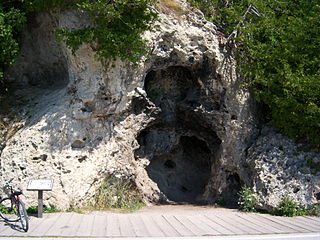
Devil's Kitchen is a small cave on the southwestern shore of Mackinac Island in Michigan, USA. The cave was carved during the Nipissing post-glacial period by the waves of Lake Huron. It consists of two hollows in a rocky cliff, one directly on top of the other.

British Landing is a place within Mackinac Island, Michigan and is located on the shore of Mackinac Island, two miles (3 km) northwest of the island's downtown and harbor. British Landing is the site of a War of 1812 amphibious operation on July 16–17, 1812, by a joint force of the British Army and their allies among the Native Americans and indigenous people of Canada. The operation led directly to the surrender of Fort Mackinac by the U.S. Army.

McGulpin Point Light was constructed as a navigational aid through the Straits of Mackinac. The light began operation in 1869, making it one of the oldest surviving lighthouses in the Straits. Only in operation until 1906, the light is located on McGulpin Point,, approximately 3 miles (4.8 km) west of Fort Michilimackinac.
Fort Drummond, also known as Fort Colyer or Fort Collier, is a military fort located on the west end of Drummond Island on Whitney Bay, in the vicinity of De Tour Village, Michigan. It is the only known military and civilian site established by British forces on American soil following the War of 1812. It was listed on the National Register of Historic Places in 1969 and designated a Michigan State Historic Site in 1956.


