Slaughter, Louisiana

Last updated

Slaughter, Louisiana
Town
Town of Slaughter
2SlaughterBankWM.JPG
The historic Bank of Slaughter
East Feliciana Parish Louisiana Incorporated and Unincorporated areas Slaughter Highlighted.svg
Location of Slaughter in East Feliciana Parish, Louisiana.
Louisiana in United States (US48).svg
Location of Louisiana in the United States
Coordinates: 30°42′59″N91°08′40″W / 30.71639°N 91.14444°W / 30.71639; -91.14444
Country United States
State Louisiana
Parish East Feliciana
Government
  MayorJanis Landry [1]
  Police ChiefWalter Smith [2]
Area
[3]
  Total5.48 sq mi (14.18 km2)
  Land5.47 sq mi (14.16 km2)
  Water0.01 sq mi (0.02 km2)
Elevation
131 ft (40 m)
Population
 (2020)
  Total1,035
  Density189.35/sq mi (73.11/km2)
Time zone UTC-6 (CST)
  Summer (DST) UTC-5 (CDT)
ZIP code
70777
Area code 225
FIPS code 22-70770
Website www.townofslaughter.org

Slaughter is a town in East Feliciana Parish, Louisiana, United States. The population was 997 at the 2010 U.S. census, down from 1,011 at the 2000 U.S. census. At the 2020 population estimates program, the U.S. Census Bureau estimated 882 people lived in the township. [4] Slaughter is part of the Baton Rouge metropolitan statistical area.

Contents

History

The name of the town is from an Illinois Central Railroad Depot for the farm of the Slaughter family. The Gloster Southern Railroad served the town from 1987 to 2008. [5] figures in the title of Michael Ondaatje's novel about legendary jazz player Buddy Bolden: Coming Through Slaughter . Slaughter was designated a town in 2002. [6]

Geography

Slaughter is located along the southern edge of East Feliciana Parish at 30°42′59″N91°8′40″W / 30.71639°N 91.14444°W / 30.71639; -91.14444 (30.716484, -91.144506). [7] The town is bordered on the south by the city of Zachary in East Baton Rouge Parish.

Louisiana Highway 19 passes through Slaughter, leading north 15 miles (24 km) to Wilson and south 20 miles (32 km) to Baton Rouge. Clinton, the East Feliciana Parish seat, is 14 miles (23 km) to the northeast.

According to the United States Census Bureau, Slaughter has a total area of 5.5 square miles (14.2 km2), of which 0.01 square miles (0.02 km2), or 0.16%, is water. [8]

Demographics

Historical population
CensusPop.Note
1900 259
1910 28710.8%
1920 215−25.1%
1930 32752.1%
1940 306−6.4%
1950 290−5.2%
1960 40339.0%
1970 58043.9%
1980 72925.7%
1990 82713.4%
2000 1,01122.2%
2010 997−1.4%
2020 1,0353.8%
U.S. Decennial Census [9]
Slaughter racial composition as of 2020 [10]
RaceNumberPercentage
White (non-Hispanic)87884.83%
Black or African American (non-Hispanic)706.76%
Native American 60.58%
Asian 30.29%
Pacific Islander 20.19%
Other/Mixed 575.51%
Hispanic or Latino 191.84%

As of the 2020 United States census, there were 1,035 people, 435 households, and 298 families residing in the town. At the 2019 American Community Survey, 87.6% of the population were non-Hispanic white, 8.0% Black and African American, 1.4% two or more races, and 3.1% Hispanic and Latin American of any race. [11] The town had a median age of 48.1.

At the 2000 U.S. census, [12] there were 1,011 people, 359 households, and 286 families residing in the village. The population density was 184.3 inhabitants per square mile (71.2/km2). There were 376 housing units at an average density of 68.6 per square mile (26.5/km2). The racial makeup of the village was 94.56% White, 3.56% African American, 0.99% Native American, 0.10% Asian, 0.40% from other races, and 0.40% from two or more races. Hispanic or Latino of any race were 0.79% of the population.

There were 359 households, out of which 38.2% had children under the age of 18 living with them, 64.6% were married couples living together, 8.9% had a female householder with no husband present, and 20.1% were non-families. 16.7% of all households were made up of individuals, and 7.5% had someone living alone who was 65 years of age or older. The average household size was 2.82 and the average family size was 3.17.

In the village the population was spread out, with 28.8% under the age of 18, 7.9% from 18 to 24, 30.8% from 25 to 44, 24.8% from 45 to 64, and 7.7% who were 65 years of age or older. The median age was 33 years. For every 100 females, there were 101.8 males. For every 100 females age 18 and over, there were 98.3 males.

The median income for a household in the village was $44,896, and the median income for a family was $46,932. Males had a median income of $34,375 versus $21,141 for females. The per capita income for the village was $17,457. About 3.4% of families and 3.5% of the population were below the poverty line, including 3.1% of those under age 18 and 5.7% of those age 65 or over.

Education

East Feliciana Parish School Board serves Slaughter. Slaughter Elementary School and Slaughter Community Charter School are located in Slaughter.

Related Research Articles

<span class="mw-page-title-main">West Feliciana Parish, Louisiana</span> Parish in Louisiana, United States

West Feliciana Parish is a civil parish located in the U.S. state of Louisiana. At the 2020 census, the population was 15,310. The parish seat is St. Francisville. The parish was established in 1824.

<span class="mw-page-title-main">West Baton Rouge Parish, Louisiana</span> Parish in Louisiana, United States

West Baton Rouge Parish is one of the sixty-four parishes in the U.S. state of Louisiana. Established in 1807, its parish seat is Port Allen. With a 2020 census population of 27,199 residents, West Baton Rouge Parish is part of the Baton Rouge metropolitan statistical area.

<span class="mw-page-title-main">St. Helena Parish, Louisiana</span> Parish in Louisiana, United States

St. Helena Parish is a parish in the U.S. state of Louisiana. At the 2020 United States census, the population was 10,920. Its seat is Greensburg. The parish was created in 1810. St. Helena Parish is part of the Baton Rouge metropolitan area.

<span class="mw-page-title-main">East Feliciana Parish, Louisiana</span> Parish in Louisiana, United States

East Feliciana Parish is a parish located in the U.S. state of Louisiana. At the 2020 census, the population was 19,531. The parish seat is Clinton.

<span class="mw-page-title-main">East Baton Rouge Parish, Louisiana</span> Parish in Louisiana, United States

East Baton Rouge Parish is the most populous parish in the U.S. state of Louisiana. Its population was 456,781 at the 2020 census. The parish seat is Baton Rouge, Louisiana's state capital. East Baton Rouge Parish is located within the Greater Baton Rouge area.

<span class="mw-page-title-main">Gardere, Louisiana</span> Census-designated place in Louisiana, United States

Gardere is an unincorporated area and census-designated place (CDP) in East Baton Rouge Parish, Louisiana, United States. The area is also known as Riverland. The population was 10,580 at the 2010 census, up from 8,992 in 2000. It is part of the Baton Rouge Metropolitan Statistical Area.

<span class="mw-page-title-main">Inniswold, Louisiana</span> Census-designated place in Louisiana, United States

Inniswold is an unincorporated area and census-designated place (CDP) in East Baton Rouge Parish, Louisiana, United States. The population was 6,180 at the 2010 census, up from 4,944 in 2000. In 2020, its population was 5,987. It is part of the Baton Rouge metropolitan statistical area.

<span class="mw-page-title-main">Merrydale, Louisiana</span> Census-designated place in Louisiana, United States

Merrydale is an unincorporated area and census-designated place (CDP) in East Baton Rouge Parish, Louisiana, United States. The population was 9,772 at the 2010 census, down from 10,427 in 2000. It is part of the Baton Rouge Metropolitan Statistical Area.

<span class="mw-page-title-main">Monticello, Louisiana</span> Census-designated place in Louisiana, United States

Monticello is a census-designated place (CDP) in East Baton Rouge Parish, Louisiana, United States. The population was 5,172 at the 2010 census, up from 4,763 in 2000. It is part of the Baton Rouge Metropolitan Statistical Area.

<span class="mw-page-title-main">Oak Hills Place, Louisiana</span> Census-designated place in Louisiana, United States

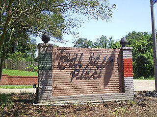
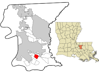
Oak Hills Place is a census-designated place (CDP) in East Baton Rouge Parish, Louisiana, United States. The population was 8,195 at the 2010 census. It is part of the Baton Rouge Metropolitan Statistical Area, and one of the most affluent suburbs of Baton Rouge.

<span class="mw-page-title-main">Shenandoah, Louisiana</span> Census-designated place in Louisiana, United States

Shenandoah is an unincorporated area and census-designated place (CDP) in East Baton Rouge Parish, Louisiana, United States. It is part of the Baton Rouge Metropolitan Statistical Area. The population was 18,399 at the 2010 census, up from 17,070 in 2000. Shenandoah consists of a number of residential subdivisions, including Shenandoah Estates, Shenandoah Park, White Oak Landing, White Oak Estates, The Woods and The Lake at White Oak.

<span class="mw-page-title-main">Village St. George, Louisiana</span> Census-designated place in Louisiana, United States

Village St. George is a census-designated place (CDP) in East Baton Rouge Parish, Louisiana, United States. The population was 7,104 at the 2010 census. It is part of the Baton Rouge Metropolitan Statistical Area.

<span class="mw-page-title-main">Westminster, Louisiana</span> Census-designated place in Louisiana, United States

Westminster is a census-designated place (CDP) in East Baton Rouge Parish, Louisiana, United States. The population was 3,008 at the 2010 census, up from 2,515 in 2000. It is part of the Baton Rouge Metropolitan Statistical Area.

<span class="mw-page-title-main">Zachary, Louisiana</span> City in Louisiana, United States

Zachary is a city in East Baton Rouge Parish, Louisiana, United States. It lies 16 miles (26 km) north of the city of Baton Rouge, and had a population of 14,960 at the 2010 census, up from 11,275 in 2000. At the 2020 census, Zachary's population increased to 19,316.

<span class="mw-page-title-main">Clinton, Louisiana</span> Town in Louisiana, United States

Clinton is a town in, and the parish seat of, East Feliciana Parish, Louisiana, United States. The town was named for New York Governor DeWitt Clinton. The population was 1,653 at the 2010 census. It is part of the Baton Rouge Metropolitan Statistical Area.

<span class="mw-page-title-main">Jackson, Louisiana</span> Town in Louisiana, United States

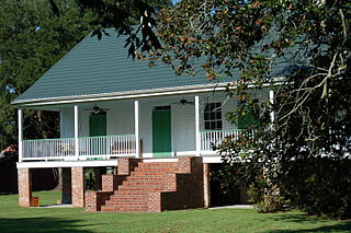
Jackson is a town in East Feliciana Parish, Louisiana, United States. The population was 3,842 at the 2010 U.S. census, down from 4,130 in 2000; the 2020 population estimates program determined Jackson had a population of 3,707. It is part of the Baton Rouge metropolitan statistical area.

<span class="mw-page-title-main">St. Gabriel, Louisiana</span> City in Louisiana, United States

St. Gabriel is a city in Iberville Parish, Louisiana, United States. The city of St. Gabriel includes the Carville neighborhood and portions of Sunchine. Part of the Baton Rouge metropolitan statistical area, it had a population of 6,677 at the 2010 U.S. census, and 6,433 at the 2020 census.

<span class="mw-page-title-main">Port Allen, Louisiana</span> City in Louisiana, United States

Port Allen is a city in, and the parish seat of, West Baton Rouge Parish, Louisiana, United States. Located on the west bank of the Mississippi River, it is bordered by Interstate 10 and US Highway 190. The population was 4,939 in 2020. It is part of the Baton Rouge metropolitan statistical area.

<span class="mw-page-title-main">St. Francisville, Louisiana</span> Town in Louisiana, United States

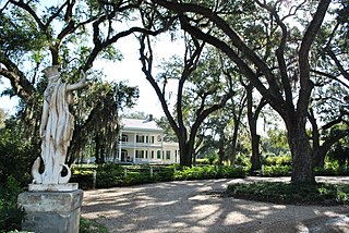
St. Francisville is a town in and the parish seat of, West Feliciana Parish, Louisiana, United States. The population was 1,765 at the 2010 U.S. census, and 1,589 at the 2020 population estimates program. It is part of the Baton Rouge metropolitan statistical area.

<span class="mw-page-title-main">Baton Rouge metropolitan area</span> Metropolitan area in Louisiana, United States

The Baton Rouge metropolitan statistical area, as defined by the United States Office of Management and Budget, or simply the Baton Rouge metropolitan area or Greater Baton Rouge, is a sprawling metropolitan statistical area surrounding the city of Baton Rouge. Including the western edge of the Florida Parishes regions, it is known as "Plantation Country", the "Capital Region", and "The 225". At the 2010 U.S. census, the metropolitan area had a population of 802,484, up from 705,973 in 2000. At the 2020 census, its population increased to 870,569, up from 2020 estimates at 858,571.

References

  1. "Mayor and Board – Town of Slaughter, Louisiana". Archived from the original on July 30, 2021. Retrieved February 28, 2021.
  2. "Police Department – Town of Slaughter, Louisiana". Archived from the original on July 30, 2021. Retrieved February 28, 2021.
  3. "2020 U.S. Gazetteer Files". United States Census Bureau. Retrieved March 20, 2022.
  4. "City and Town Population Totals: 2010-2020". The United States Census Bureau. Retrieved July 22, 2021.
  5. "Gloster Southern Railroad Company LLC--Discontinuance of Service Exemption--in Amite and Wilkinson Counties, MS and East Feliciana Parish, LA". Surface Transportation Board . Retrieved February 5, 2024.
  6. "Boundary Changes". Geographic Change Notes: Louisiana. Population Division, United States Census Bureau. May 19, 2006. Archived from the original on February 6, 2006. Retrieved October 24, 2008.
  7. "US Gazetteer files: 2010, 2000, and 1990". United States Census Bureau. February 12, 2011. Retrieved April 23, 2011.
  8. "Geographic Identifiers: 2010 Demographic Profile Data (G001): Slaughter town, Louisiana". American Factfinder. U.S. Census Bureau. Archived from the original on February 13, 2020. Retrieved February 9, 2016.
  9. "Census of Population and Housing". Census.gov. Retrieved June 4, 2015.
  10. "Explore Census Data". data.census.gov. Retrieved December 28, 2021.
  11. "2019 Demographic and Housing Estimates". data.census.gov. Retrieved July 22, 2021.
  12. "U.S. Census website". United States Census Bureau . Retrieved January 31, 2008.