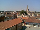
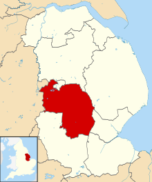
Sleaford is a market town and civil parish in the North Kesteven district of Lincolnshire, England. Centred on the former parish of New Sleaford, the modern boundaries and urban area include Quarrington to the south-west, Holdingham to the north and Old Sleaford to the east. The town is on the edge of the fertile Fenlands, 11 miles (18 kilometres) north-east of Grantham, 16mi (26km) west of Boston, and 17mi (27km) south of Lincoln. Its population of 17,671 at the 2011 Census made it the largest settlement in the North Kesteven district; it is the district's administrative centre. Bypassed by the A17 and the A15, it is linked to Lincoln, Newark, Peterborough, Grantham and King's Lynn.
The first settlement formed in the Iron Age where a prehistoric track crossed the River Slea. It was a tribal centre and home to a mint for the Corieltauvi in the 1st centuries BC and AD. Evidence of Roman and Anglo-Saxon settlement has been found.
During the period of Danelaw, the area was actively populated. There are not only many names of places in the area that end in -by or -thorpe, but also the -gate ending of streets in Sleaford itself (North Gate, Eastgate, Westgate, South Gate and Watergate). All these bear witness to a population with a profoundly Scandinavian origin. [2]
The medieval records differentiate between Old and New Sleaford, the latter emerging by the 12th century around the present-day market place and St Denys' Church; Sleaford Castle was also built at that time for the Bishops of Lincoln, who owned the manor. Granted the right to hold a market in the mid-12th century, New Sleaford developed into a market town and became locally important in the wool trade, while Old Sleaford declined.
From the 16th century, the landowning Carre family kept tight control over the town – it grew little in the early modern period. The manor passed from the Carre family to the Hervey family by the marriage of Isabella Carre to John Hervey, 1st Earl of Bristol in 1688. The town's common land and fields were legally enclosed by 1794, giving ownership mostly to the Hervey family. This coincided with canalisation of the Slea. The Sleaford Navigation brought economic growth until it was superseded by the railways in the mid-1850s. In the 20th century, the sale of farmland around Sleaford led to the development of large housing estates.
Sleaford was mainly an agricultural town until the 20th century with a cattle market. Seed companies such as Hubbard and Phillips and Sharpes International were established in the late 19th century. The arrival of the railway made the town favourable for malting, but the industry has since declined. In 2011, the commonest occupations were in wholesale and retail trading, health and social care, public administration, defence and manufacturing. Regeneration of the town centre has helped to regenerate the earlier industrial areas, including construction of the National Centre for Craft & Design (The Hub) on an old wharf.[3]
The town is on the edge of the Fens, a low-lying region of the East of England which, before drainage from the 17th to the 20th centuries, were marshy and liable to flooding. Draining has revealed nutrient-rich soils and allowed 88 per cent of the land to be cultivated, mainly as arable. Most of it qualifies amongst the most productive farmland in the country.[8][9] Two Local Nature Reserves sit within the civil parish boundaries: Lollycocks Field, providing mostly wildflower and wetlands habitats alongside Eastgate, and Mareham Pastures, consisting of wildflower meadows, new woodland, hedges and open grassland.[10][11]
Climate
The British Isles experience a temperate, maritime climate with warm summers and cool winters.[12] Lincolnshire's position on the east of the British Isles allows for a sunnier and warmer climate relative to the national average, and it is one of the driest counties in the UK.[13] In Sleaford, the average daily high temperature peaks at 21.1°C (70.0°F) in July and a peak average daily mean of 17.2°C (63.0°F) occurs in July. The lowest daily mean temperature is 4.1°C (39.4°F) in January; the average daily high for that month is 7.0°C (44.6°F) and the daily low is 1.3°C (34.3°F) (the latter also occurs in February).[14] The East of England tends to be sheltered from strong winds relative to the north and west of the country. Despite this, tornadoes form more often in the East of England than elsewhere;[15] Sleaford suffered them in 2006 and 2012, both causing damage to property.[16][17]
The earliest records of the place-name Sleaford are found in a charter of 852 as Slioford and in the Anglo-Saxon Chronicle as Sliowaford. In the Domesday Book (1086), it is recorded as Eslaforde and in the early 13th century as Sliforde.[20] In the 13th century Book of Fees it appears as Lafford.[21] The name is formed from the Old English words sliow and ford, together meaning 'ford over a muddy or slimy river'.[20]
Early period
An electrum stater of the Corieltauvi, probably struck at Sleaford in the mid-1st century BC. Diameter 17–19mm.
Archaeological material from the Bronze Age and earlier has been recovered and excavations have shown there was unsustained late-Neolithic and Bronze Age human activity in the vicinity.[22][23] The earliest known permanent settlement dates from the Iron Age, where a track northwards from Bourne crossed the River Slea.[22] Although only sparse pottery evidence has been found for the middle Iron Age period, 4,290 pellet mould fragments, probably used for minting and dated to 50 BC–AD 50, have been uncovered south-east of the modern town centre, south of a crossing of the River Slea and near Mareham Lane in Old Sleaford. The largest of its kind in Europe, the deposit has led archaeologists to consider that the site in Old Sleaford as one of the largest Corieltauvian settlements in the period and possibly a tribal centre.[22][24]
During the Roman occupation of Britain (AD 43–409), the settlement was "extensive and of considerable importance".[25] Its location beside the Fens may have made it economically and administratively significant as a centre for stewards and owners of fenland estates.[26] There are signs of a road connecting Old Sleaford to Heckington (about 4+1⁄2mi or 7.2km east), where Roman tile kilns have been uncovered and may imply the presence of a market.[27] When the first roads were built by the Romans, Sleaford was bypassed as "less conveniently located" and more "geared to native needs".[28] A smaller road, Mareham Lane, which the Romans renewed, ran through Old Sleaford, and south along the fen edge towards Bourne. Where it passed through Old Sleaford, excavations have shown a large stone-built domestic residence, associated farm buildings, corn-driers, ovens and field systems, all from the Roman period, and a number of burials.[29] Other Roman remains, including a burial, have been excavated in the town.[30][31]
There is little evidence of continuous settlement between the late Roman and Anglo-Saxon periods[27] but the Saxons did establish themselves eventually. South of the modern town, a 6th to 7th-century cemetery has been uncovered with an estimated 600 burials, many showing signs of pagan burial rites.[27][n 1] The now ruined Church of St Giles/All Saints at Old Sleaford has been discovered[27] and excavations of the market place in 1979 uncovered Anglo-Saxon remains from the 8th–9th centuries, indicating some form of enclosure with domestic features.[33]
The earliest documentary reference to Sleaford occurs in a 9th-century charter,[34] when it was owned by Medehamstede Abbey in Peterborough, a Mercian royal foundation.[35] There is little evidence of estate structure until the late Saxon period,[27] but there may have been a market and court before the Norman Conquest, and it may well have been an economic and jurisdictional centre for surrounding settlements.[36] The Slea played a big part in the town's economy: it never ran dry or froze, and by the 11th century it supported a dozen watermills. The mills and others in nearby Quarrington and the lost hamlet of Millsthorpe, formed the "most important mill cluster in Lincolnshire".[37]
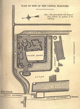
In the later Middle Ages, the Romano-British settlement became known as Old Sleaford, while New Sleaford was a settlement centred on St Denys' Church and the market place.[38] The Domesday Book of 1086 has two entries under Eslaforde (Sleaford) recording land held by Ramsey Abbey and the Bishop of Lincoln.[n 2] The location of the manors recorded in Domesday is unclear. One theory endorsed by Maurice Beresford is that they focused on the settlement at Old Sleaford, due to evidence that New Sleaford was planted in the 12th century by the bishop to increase his income,[n 3] a development associated with the construction of Sleaford Castle between 1123 and 1139.[40] Beresford's theory has been criticised by the local historians Christine Mahany and David Roffe[n 4] who have reinterpreted the Domesday material and argued that in 1086 the Bishop's manor included the church and associated settlement which became "New" Sleaford.[42][43]
A charter to hold a fair on the feast day of St Denis was granted by King Stephen to Alexander, Bishop of Lincoln, in 1136–1140. Between 1154 and 1165, Henry II granted the bishop of Lincoln the right to hold a market at Sleaford; Bishop Oliver Sutton argued in 1281 that his right to hold a market and fair had existed since time immemorial. In 1329, Edward III confirmed the market. In 1401, Henry IV granted the bishop fairs on the feast days of St Denis and St Peter's Chains.[44] A survey of 1258 is the first to mention burgage tenure;[45] tenants in the nearby hamlet of Holdingham held tofts with other land, while those in New Sleaford held only tofts, indicating that demesne farming centred on the hamlet.[46] The town later had at least two guilds comparable to those found in developed towns.[47] However, there was no formal charter outlining its freedoms;[48] it was not a centre of trade, and tight control by the bishops meant the economy was mainly geared to serve them. So it retained a strong tradition of demesne farming well into the 14th century.[49][50] As the economic initiative passed more to burgesses and middlemen who formed ties with nearby towns such as Boston, evidence suggests that Sleaford developed a locally important role in the wool trade.[51][52] In the Lay Subsidy of 1334, New Sleaford was the wealthiest settlement in the Flaxwell wapentake, with a value of £16 0s. 8d.1/4d.[53] Meanwhile, Old Sleaford, an "insignificant" place since the end of the Roman period, declined and may have been deserted by the 16th century.[54][55]
Early modern period
The tomb of Sir Edward Carre (died 1618) in St Denys' Church
The manor of Old Sleaford was owned in the late 15th and early 16th centuries by the Hussey family, but John Hussey, 1st Baron Hussey of Sleaford was executed for treason for his part in the Lincolnshire Rising. The manor and his residence at Old Place reverted to the Crown and were later sold to Robert Carre.[56][57] George Carre or Carr from Northumberland had settled in Sleaford by 1522 when he was described as a wool merchant.[58][59] His son Robert bought Hussey's land and the castle and manor of New Sleaford from Edward Clinton, 1st Earl of Lincoln.[60][n 5] His eldest surviving son Robert, founded Carre's Grammar School in 1604, and his youngest son Edward was created a baronet; his son founded Sleaford Hospital in 1636.[62] The last male descendant died in 1683 and the heiress, Isabella Carre, married John Hervey, Earl of Bristol, in whose family the estates remained until the 1970s.[63][64] The Carres and Herveys had a strong influence: while extracting dues from their tenants, they took leading tradesmen to the Exchequer Court to gain legal force behind their monopoly on charging tolls on market and cattle traders and for driving animals through the town.[65]
Industry was slow to take hold. By the second half of the 18th century, Cogglesford Mill was the only working corn mill in the town.[66] An old mill at the junction of Westgate and Castle Causeway supplied hemp to the growing rope-making business of the Foster and Hill families.[64] As local historian Simon Pawley wrote, "In many respects, things had changed little [by 1783] since the survey of 1692," with few of the buildings or infrastructure being improved.[67] Major changes to agriculture and industry took place in the last decade of that century. From the Middle Ages, Sleaford was surrounded by three open fields known as North, West and Sleaford Fields. When these were enclosed in 1794, over 90 per cent of the 1,096 acres (444 hectares) of the open land was owned by Lord Bristol. Despite the costs of fencing and re-organisation, the system was easier to farm and cottages were built closer to fields, while the landowner could charge more rent owing to the increased profitability of the land; those who lost out were the cottagers, who could no longer keep a few animals grazing on the common land at no cost.[68] The process allowed the land boundaries and pathways to be tidied; Drove Lane, running to Rauceby, was shifted north and straightened.[69]
Industrial development
Sleaford, as it appeared in 1891. The major roads are marked in red; railways in grey and rivers in blue. Key: (1) Market Place, (2) St Denys' Church, (3) Manor House, (4) Carre's Grammar School, (5) Westholme House, (6) Castle, (7) Station, (8) Old Place, (9) the remains of St Giles's Church, (10) the Union workhouse.
Canalisation of the River Slea began in the 1790s. Canals in England were constructed from the 1760s to make inland trade easier; Sleaford's businessmen were keen to benefit from these. Sleaford Navigation opened in 1794.[69][71] It eased the export of farm produce to the Midlands and the import of coal and oil. Mills along the Slea benefited and wharves were constructed around Carre Street.[72][73] Between 1829 and 1836 the navigation's toll rights increased in value 27 times over.[72] The railways emerged in the 19th century as an alternative to canals and arrived at the town in 1857, when a line from Grantham to Sleaford opened.[74][75] This made trading easier and improved communications,[n 6][76] but led to the decline of the Navigation Company. Income from tolls decreased by 80 per cent between 1858 and 1868; it made its first loss in 1873 and was abandoned in 1878.[77] The town's rural location and transport links led in the late 19th century to the rise of two local seed merchants: Hubbard and Phillips, and Charles Sharpe; the former took over the Navigation Wharves, and the latter was trading in the US and Europe by the 1880s.[78] The railway, Sleaford's rural location and its artesian wells, were key factors in the development of the 13-acre (5-hectare)Bass & Comaltings complex at Mareham Lane (1892–1905).[79]
Sleaford's population more than doubled from 1,596 in 1801 to 3,539 in 1851.[80] Coinciding with this is the construction or extension of public buildings, often by the local contractors Charles Kirk and Thomas Parry.[n 7][81][82][83] The gasworks opened in 1839 to provide lighting in the town.[84] Sleaford's Poor Law Union was formed in 1836 to cater for the town and the surrounding 54 parishes. A workhouse was built by 1838, able to house 181 inmates.[85] Despite these advances, the slums around Westgate were crowded, lacking in sanitation and ridden by disease;[n 8] the local administration failed to deal with the matter until 1850, when a report on the town's public health by the General Board of Health heavily criticised the situation and set up a Local Board of Health to undertake public works.[86] By the 1880s, Lord Bristol had allowed clean water to be pumped into the town, but engineering problems and a reluctance to sell land to house the turbines had delayed the introduction of sewers.[87]
Post-industrial period
Officer Training School at RAF Cranwell, near Sleaford.
Although hardly damaged in the First and Second World Wars,[88] Sleaford has close links with the Royal Air Force due to proximity to several RAF bases, including RAF Cranwell and RAF Waddington. Lincolnshire's topography – flat and open countryside – and its location in the east of the country made it ideal for the airfields being constructed in the First World War. Work began on Cranwell in late 1915; it was designated an RAF base in 1918 and the RAF College opened in 1920 as the world's first air academy.[89][90] A Cranwell branch railway linking Sleaford station with the RAF base opened in 1917 and closed in 1956.[91][92] During the Second World War, Lincolnshire was "the most significant location for bomber command" and Rauceby Hospital, south-west of Sleaford, was requisitioned by the RAF as a specialist burns unit which the plastic surgeon Archibald McIndoe regularly visited.[89]
Sleaford's population remained static between the wars, but the Great Depression in the 1930s caused unemployment to rise.[93] The Council housing put up along Drove Lane proved insufficient for the low-income families after the Westgate slums were cleared in the 1930s; Jubilee Grove opened in that decade to meet the demand.[94]
In the post-war period, there were housing developments at St Giles Avenue, the Hoplands, Russell Crescent, Jubilee Grove and Grantham Road.[95] Parts of the town were redeveloped: in 1958, the Bristol Arms Arcade opened, the Corn Exchange was demolished in the 1960s and the Waterside Shopping Precinct opened in 1973, as did Flaxwell House, designed to house a department store, though later becoming the national headquarters for Interflora.[96]
By 1979, the major landowner, Victor Hervey, 6th Marquess of Bristol, was heavily in debt and sold most of his estates in Sleaford and Quarrington. The estate office closed in 1989.[97] Much of the land went to property developers and subsequent decades brought new housing and a considerable rise in population.[98] According to a council report, people were attracted to the town by "the quality of life, low crime rates, relatively low house prices and good-quality education".[99] From 1981 to 2011, Sleaford's population rose from 8,000 to 18,000; the growth rate in 1991–2001 was the fastest of any town in the county.[100][101] The infrastructure struggled to cope, especially with increased traffic congestion. Two bypasses opened and a one-way system was introduced, a process that Simon Pawley argues accelerated the decline of the High Street.[97] In the early 2000s, the Single Regeneration Budget of £15 million granted to Sleaford improved the town centre and funded development of the Hub (from 2011 to 2021, the National Centre for Craft & Design) in the old Navigation wharves area.[102]
Economy
Employment
Sleaford served the surrounding agricultural communities and the town maintained a weekly market throughout the 19th century and a livestock market on Northgate from 1874 until 1984.[4][103] According to a 2010 council report, the public sector was the town's main employer, along with agriculture and manufacturing. Unemployment was lower than the national average as were wages reflecting pay in the food processing and agricultural industries.[99] At the 2011 Census, the largest group of working-age persons by economic activity are those in full-time employment, who make up 43.8 per cent of this section of the population, while 15 per cent are part-time employees and 7.7 per cent are self-employed; 15 per cent of the working-age population were retired, 4.2 per cent unemployed, with 40 per cent of those in long-term unemployment and roughly one third aged 16 to 24. The largest socio-economic grouping is those working in lower-tier managerial or administrative roles (21.9 per cent), followed by semi-routine (17.8 per cent), routine (15 per cent) and intermediate (12.5 per cent) occupations; no other group comprised 10 per cent or more. In terms of industry, the most common, based on those working in the sector, are the wholesale and retail trades (including automotive repairs) at 16.9 per cent, health and social care (13.4 per cent), public administration and defence (13.3 per cent) and manufacturing (10.9 per cent), with no other groups representing 10 per cent or more.[104] An unemployment survey of Lincolnshire in 2014 found that the county experienced a decline in unemployment (based on Jobseekers Allowance claimants) by 29 per cent over the preceding 12 months, while the county's unemployment rate was marginally below the national average.[105]
Regeneration
In 2011 North Kesteven District Council produced a 25-year strategy to regenerate the town, since its rapid growth since the 1990s had outgrown improvements to its infrastructure. It planned future residential developments and outlined ways to improve the town centre. It suggested developing more parking around the centre and reverting parts of the one-way system, developing southern Southgate and turning Money's Yard into an attraction to link with the National Centre for Craft and Design.[106] North Kesteven District Council granted planning permission for a £56m project to redevelop the derelict Bass Maltings site by converting it into residential and retail space and creating about 500 permanent jobs.[107][108] The development including a supermarket was delayed when the town council opposed a link road through part of the recreation ground.[109][110]Tesco, who had pledged to invest in a £20million store in the development withdrew in January 2015 following financial set-backs.[111]
In 1563 there were 145 households in New Sleaford (including 20 in Holdingham),[115] plus 10 in Old Sleaford and 17 in Quarrington.[116] In the late 17th and early 18th centuries, the diocese recorded that there were "more than 250 families" in the ecclesiastical parish of Sleaford,[117] with a further 35 in the parish of Quarrington.[118] One estimate puts the population of New Sleaford at 800 to 900 at this time.[119] The first official census was conducted in 1801 and recorded a population of 1,596 in New Sleaford (including Holdingham); combined with Old Sleaford and Quarrington, this gave a population of 1,812 in the area covered by today's Sleaford civil parish.[n 12] Following the opening of Sleaford Navigation in 1792 and the flourishing of the town's economy this produced (combined with the effects of inflated agricultural prices during the Napoleonic wars), Sleaford's population rose steadily in the first half of the 19th century.[119] It totalled 3,539 in New Sleaford and 4,160 across all the three parishes by 1851. The population grew much more slowly between the 1850s and the 1880s, before witnessing further growth that took the urban district's population to 6,427 by 1911 (incorporating New Sleaford, Old Sleaford, Holdingham and Quarrington).[n 12]
Slower rates were recorded for the urban district between then and the 1931 census, though the pace picked up again in the 1930s; by the outbreak of the second world war in 1939 there were 7,835 residents. Sleaford's population grew very slowly in the post-war years, reaching 7,975 by 1971,[120][121] largely due to the fact that Lord Bristol remained owner of the vast majority of the undeveloped land around the town. However, as the 6th Marquess sold the land from the 1960s onwards and speculative housing blossomed around Sleaford, the civil parish's population expanded rapidly;[122] the population growth rate between 1991 and 2001 was the fastest of any town in Lincolnshire.[123] Between 1981 and 2011, the population more than doubled, reaching 17,671;[124] this had risen by a further 12% to 19,815 by the 2021 census.[125] This accounts for 17% of North Kesteven's population, making Sleaford the most populous civil parish in the district.[126]
Ethnicity, nationality and religion
According to the 2021 census, Sleaford's population was 96.3% White; 1.4% Asian or British Asian; 0.4% Black, African, Caribbean or Black British; 1.4% mixed or multi-ethnic; and 0.5% other ethnicities.[127] The population is therefore less ethnically diverse than England as a whole, where 81.0% were White, 9.6% Asian or British Asian, 4.2% Black, African, Caribbean or Black British, 3.0 mixed and 2.2% other.[128]
Parish-level data about country of origin and religion have not yet been published for the 2021 census. The previous census, in 2011, recorded that 92.7% of Sleaford's population were born in the United Kingdom, compared with 86.2% nationally; 4.3% were born in European Union countries other than the UK and Ireland; for England, the figure was 3.7%. 2.6% of the population was born outside the EU, whereas the total for England was 9.4%.[129][130]
In the 2011 census, 71.6% of Sleaford's population said they were religious and 21.7% said they did not follow a religion, indicating slightly higher levels of religiosity than in England as a whole (where the figures are 68.1% and 24.7% respectively). However, compared to England's population, Christians were a much higher proportion of the Sleaford's population (70.3%), and all other groups were present at a lower proportion than the national rates; Muslims were the largest religious minority, accounting for 0.4% of the town's residents compared with 5% nationally; all other groups were present in very low numbers.[129][130]
Ethnicity (2021)[127][128] and nationality and religious affiliation (2011)[129][130]
White
Asian or British Asian
Black, African, Caribbean or Black British
Mixed or multi-ethnic
Other ethnicity
Born in UK
Born in EU (except UK and Ireland)
Born outside EU
Religious
Did not follow a religion
Christian
Muslim
Other religions
Sleaford
96.3%
1.4%
0.4%
1.4%
0.5%
92.7%
4.3%
2.6%
71.6%
21.7%
70.3%
0.4%
1.0%
England
81.0%
9.6%
4.2%
3.0%
2.2%
86.2%
3.7%
9.4%
68.1%
24.7%
59.4%
5.0%
2.5%
Household composition, age, health and housing
Gender, age, health and household characteristics (2011)[129][130]
Parish-level data about household composition, age and housing have not yet been published for the 2021 census. In the 2011 census, 48.4% of the population were male and 51.6% female. Of the population over 16, 50.3% were married, compared to 46.6% in England; 28.9% were single (a smaller proportion than in England where it is 34.6%), 10.5% divorced (compared with 9% in England), 7.1% widowed (comparable with 6.9% for all of England), 3.1% separated and 0.1% in same-sex civil partnerships (2.7% and 0.2% respectively in England). In 2011, there were 7,653 households in Sleaford civil parish. It has a roughly average proportion of one-person households (29.2% compared with England's figure of 30.2%); most other households consist of one family (65.4% of the total, higher than England's 61.8%).[129][130]
The 2011 census showed Sleaford's population to be very slightly higher than the national average; the mean age was 40 and the median 41 years, compared with 39.3 and 39 for England. 24.3% of the population was under 20, versus 24% of England's, and 23.2% of Sleaford's population was aged over 60, compared with 22% of England's population.[129][130] In 2011, 82.1% of the population were in good or very good health, compared to 81.4% in England.[129][130]
As of 2011, Sleaford has a higher proportion of people who own their homes with or without a mortgage (68.5%) than in England (63.3%), a slightly lower proportion of people who privately rent (15.8% compared with 16.8%) and a much smaller proportion of social renters (13.8% compared with 17.7% nationally). The proportion of household spaces which are detached houses is higher than average (39.2% compared with 22.3%), while the proportion of terraced household spaces is lower (19.3% against 24.5% nationally). The proportion of purpose-built flats is also lower (8.7% versus 16.7%).[129][130]
Workforce and deprivation
Economic characteristics of residents aged 16 to 74 (2021)
In 2021, 63.1% of Sleaford's residents aged between 16 and 74 were economically active (including full-time students), compared with 60.9% for all of England. 60.6% were in employment, compared with 57.4% nationally. The rate of economically inactive people aged 16 to 74 was 36.9%, lower than the rate in England as a whole (39.1%).[128][131]
The 2021 census revealed that the most common industries residents worked in were: public administration, education and health (combined 37.2%, much higher than the national rate of 30.3%), retail, hotels and accommodation (combined 21.0%, slightly higher than England's rate of 19.9%), finance, real estate, professional or administrative services (combined 10.6%, well below the English rate of 17.4%), and manufacturing (10.0%, above the national rate of 7.3%). No other sectors accounted for more than 10% of the population and were comparable to the national rate, except for transport and communication, which was almost 40% lower than the rate in England as a whole.[128][132]
In terms of occupational composition, in 2021 Sleaford's workforce was broadly similar to the workforce in the whole of England. It has slightly lower proportions of people in professional, associate professional and technical roles (30.4%) and managerial occupations (11.1%). There are slightly higher proportions of people in caring, leisure and other service occupations (10.3%), process, plant and machine operatives (8.8%), and elementary occupations (11.4%).[128][133]
The government's Indices of Multiple Deprivation (2019) show that North Kesteven contains the lowest level of deprivation of any district in Lincolnshire, with only 0.7% of the district's population living in places in the most deprived decile nationally.[134] The indices divided the Sleaford parish into 10 statistical areas (LSOAs). Of these 10 areas, five placed within the least-deprived 30% of LSOAs nationally (one placed in the least-deprived 10% nationally); these were mostly concentrated in the west of the town, especially in Quarrington and the western parts of the Holdingham ward. However, the parts of the Westholme and Castle wards clustered around the town centre and the eastern part of Holdingham ward fall within the most-deprived 40% of areas nationally, with some of these LSOAs having even higher levels of deprivation.[135]
The A17 road from Newark-on-Trent to King's Lynn bypasses Sleaford from Holdingham Roundabout to Kirkby la Thorpe.[136] It ran through the town until the bypass opened in 1975.[137][138] The Holdingham roundabout connects the A17 to the A15 road from Peterborough to Scawby. It also passed through Sleaford until 1993, when its bypass was completed.[139][140] Three roads meet at Sleaford's market place: Northgate (B1518), Southgate and Eastgate (B1517). A one-way system set up in 1994 creates a circuit around the town centre.[136][141]
The River Slea through the town was converted into use as a canal for much of the 19th century. Plans to canalise it were drawn up in 1773,[69][147] but faced opposition from land-owners who feared it might affect the drainage of fens. Plans were approved in 1791 with the support of Brownlow Bertie, 5th Duke of Ancaster and Kesteven who owned estates and quarries that he hoped would benefit. An Act of Parliament passed in 1792, establishing the Sleaford Navigation, which opened two years later.[69][71] After falling revenues due to competition from the railways, the navigation company closed in 1878. The river, although no longer navigable, passes under Carre Street and Southgate.[77] The Nine Foot Drain, also unnavigable, meets the Slea just before Southgate.[136]
Governance
Local government
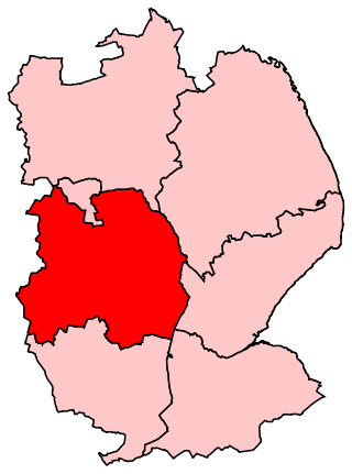
Sleaford is in the North Kesteven District of Lincolnshire (coloured red on this map).
There are three tiers of local government covering Sleaford, at parish, district and county level: Sleaford Town Council, North Kesteven District Council and Lincolnshire County Council. The town council has its headquarters at the Town Hall in Quayside House, part of the modern Navigation Yard development off Carre Street.[148][149] The district council is also based in Sleaford, at the Council Offices on Kesteven Street, which had been built as a row of houses called Lafford Terrace in the 1850s before being bought by the former Kesteven County Council for offices in 1925.[150][151]
New Sleaford and Old Sleaford were both ancient parishes, with New Sleaford sometimes being referred to in early documents as Great Sleaford, and Old Sleaford as Little Sleaford or East Sleaford.[152] From the early medieval period, New Sleaford was in the Flaxwell wapentake and Old Sleaford in the Ashwardhurn one.[153] The main part of the built-up area was in New Sleaford, which parish historically also included the rural hamlet of Holdingham to the north-west.[154]
The parish of New Sleaford, excluding the hamlet of Holdingham, was made a local board district in 1850, governed by an elected local board.[156][157] Holdingham was subsequently made its own civil parish in 1866.[154] The New Sleaford district was enlarged in 1877 to also cover the parishes of Holdingham, Old Sleaford and Quarrington.[158][159]
Such districts were reconstituted as urban districts in 1894.[160] Despite having included both Old and New Sleaford since 1877 the official name of the district remained "New Sleaford" until 1900 when it was changed to just "Sleaford".[161] The Sleaford Urban District contained the four parishes of Holdingham, New Sleaford, Old Sleaford and Quarrington; as urban parishes they had no parish councils of their own, being directly administered by the urban district council.[162]
On a Wreath of the Colours an Eagle wings extended and head downwards and to the sinister proper holding in the beak an Ear of Wheat stalked and leaved Or.
Gules on a Chevron Or three Estoiles Sable on a Chief Argent as many Trefoils slipped Vert.
Granted to the urban district council on 26 October 1950.[163]
Sleaford Urban District Council was granted a coat of arms on 26 October 1950 and after it was abolished the arms were used by its successor, Sleaford Town Council. The arms are blazoned: Gules on a Chevron Or three Estoiles Sable on a Chief Argent as many Trefoils slipped Vert. The trefoils in the chief are from the arms of the Marquess or Bristol, while the lower portion of the shield is the arms of the Carre family. Its crest is blazoned: On a Wreath of the Colours an Eagle wings extended and head downwards and to the sinister proper holding in the beak an Ear of Wheat stalked and leaved Or, the eagle symbolises Sleaford's links with the Royal Air Force and the ear of wheat represents agriculture.[164][165][166]
Sleaford Urban District was abolished in 1974, being absorbed into the new district of North Kesteven. A successor parish called Sleaford was created covering the area of the former urban district, which therefore had the effect of finally abolishing the four parishes of Holdingham, New Sleaford, Old Sleaford and Quarrington.[167] The new parish council declared its parish to be a town, allowing it to take the style "town council" and letting the chair of the council take the title of mayor.[168]
Before 1832, Sleaford was in the Lincolnshire parliamentary constituency, which encompassed all of the county except for four boroughs. In the 1818 election, 49 of the 2,000 people living in New and Old Sleaford and Quarrington qualified to vote. In 1832, the Reform Act widened the franchise and divided Lincolnshire. Sleaford was in the South Lincolnshire constituency that elected two members to Parliament.[169] Following the 1867 reforms, the South Lincolnshire constituency's borders were redrawn, but Sleaford remained within it.[170] The franchise was widened by the reforms so that roughly 15% (202) of males in Sleaford and Quarrington could vote in 1868.[171] The constituency was abolished in 1885 and the Sleaford constituency formed. It merged with the Grantham seat in 1918. In 1997, Sleaford was reorganised into Sleaford and North Hykeham.[172][173]
Sleaford hosts the annual Question Time NK, in which students across North Kesteven come together and provide questions on a range of topics to a panel of experts, politicians and heads.[176] The event is based around the political debate programme Question Time and is designed to encourage the youth to get involved in politics. The 2023 event included John Turner, Chief Executive for NHS Lincolnshire Integrated Care Board, Richard Wright from North Kesteven District Council, and 2 other experts; with the host being Melvyn Prior, a BBC Radio Lincolnshire presenter.[177] The recorded event was published and commented on by the two 2023 Heads of School Council from Carre's Grammar School.[178]
In 1879, an Act of Parliament was passed to set up a water company for the town; pumping machinery was installed and works constructed in 1880 to provide a clean water supply to the town. In 1948, the council took over the company and in 1962 its operation was handed to the Kesteven Water Board, which was absorbed by the Anglian Water Authority in 1973.[184][185]
The County Council promoted a Bill to Parliament to build an electricity generating station which passed in 1900. It was built at the cost of £6,700 in 1901 on Castle Causeway and remained there until nationalisation in 1948.[186] Following nationalisation, electricity was provided by the East Midlands Electricity Board until it was privatised in 1990.[187] A "virtually carbon neutral" straw-burning power-station at Sleaford opened in 2013; capable of supplying electricity to 65,000 homes, it is powered by straw bales from farms within a 50-mile (80-kilometre) radius. Most electricity generated is fed into the National Grid and the facility provides free heat to public buildings in the town.[188]
The Sleaford Gas Light Company was formed in 1838. The following year gas lighting was provided and a gasworks was constructed in Eastgate. In 1866, the company was incorporated; in 1895–96, the works were rebuilt and lit the town until the company was nationalised in 1948.[189] Gas ceased to be made there in the 1960s and the original buildings were retained, although later extensions were demolished in 1966–1968.[190]
Sleaford Library houses a local and family history section and microfiche machine. It was refurbished in 2010, but, as of 2014, was listed by the county council as "undersized".[191][192]
Sleaford has four primary schools. In 1726 William Alvey bequeathed land to fund teaching children in Sleaford. The school and master's house for Alvey's Endowed School, a national school, was built in 1851.[196] New buildings for the infants' school were constructed in 1888.[197] William Alvey Church of England School is housed in the same buildings. It became an academy in 2012.[198][n 17] St Botolph's School is a Church of England Primary School, which opened at its current site in 2002.[200] Church Lane School is housed in buildings constructed in 2002, when the original school house was demolished;[201] in 2013, it had c. 201 children on roll.[202] Our Lady of Good Counsel Roman Catholic School had 155 pupils on roll in 2011.[203]
In 1835, there were eight day schools and three Sunday schools in New Sleaford and two daily schools in Old Sleaford.[204] An infant school in the old playhouse on Westgate opened in 1855; Wesleyan schools attached to the chapel on North Street accommodated up to 200 pupils.[205] In addition to private girls' schools, short-lived private schools for boys were established by Mr Herring and Charles Boyer in 1851, Henry Carruthers, and Edwin Reginald Dibben in 1870 in competition with the grammar school.[206][207] Charles Kirk built a school and chapel at Quarrington in 1867. It became St Botolph's Primary School and in 2002 moved to a new site.[208] In 1879, an art school was established in Duke Street in connection with the Science and Art Department; by 1896, two Wesleyan schools and a Catholic school were also in operation.[209]
Carre's Grammar School was founded in 1604 by a bequest of Robert Carre of Aswarby.[215] It has received Specialist Sports and Science statuses,[216][217] became an academy in 2011 and was judged to be "good" by Ofsted in 2013, at which time it had 817 pupils, including the co-educational sixth form.[217] Sleaford and Kesteven High School for Girls was established in 1902.[218][219] It has specialist art status,[220][221] became an academy in 2011 and was judged to be "good" by Ofsted in 2013, at which time there were 825 pupils on roll, including those in the co-educational sixth form.[222] St George's opened in 1908 as Sleaford Council School.[223][197] It has received specialist technology college status, converted to an academy in 2010 and operates a satellite school at Ruskington.[224][225][226] St George's had 2,247 pupils on roll in 2012, across both sites and including the sixth form; when assessed by Ofsted in that year, was judged to be "good".[224]
Religion
Constructed in the Decorated Gothic style, much of the nave of St Denys' Church dates to the 14th century.
Ecclesiastical history
New Sleaford had a church and priest by the time of the Domesday Book (1086) and the vicarage was founded in 1274. During the Commonwealth (1649–60), the vicar was expelled and replaced by Puritan ministers, the last of whom was removed following the Restoration in 1660 and replaced with an Anglican clergyman.[227][228] In 1616, the vicarage was valued at £8 and in 1872 at £180.[229] As of 2015, the ecclesiastical parish of St Denys, Sleaford, encloses the town of Sleaford and hamlet of Holdingham north of the railway line and does not include Quarrington.[230] It falls within the Lafford Deanery, the Lincoln Archdeaconry and the Diocese of Lincoln. The patron is the Bishop of Lincoln and the incumbent vicar is the Rev. Philip Anthony Johnson, who was instituted in 2013.[231][232][233]
Old Sleaford was in the possession of Ramsey Abbey at the time of Domesday and later Haverholme Priory, and was eventually served by a vicar; the church was dedicated either to St Giles or to All Saints. At the Dissolution of the Monasteries (1536–41), the king took over collection of the tithes, eventually leasing them to Thomas Horseman and then selling them to Robert Carre. In the 17th century, the rectory of Quarrington and the vicarage were combined to form the parish of Quarrington with Old Sleaford.[234][235] The parish boundaries of New Sleaford and Quarrington with Old Sleaford were last altered in 1928.[236][237]
The prebendary of New Sleaford or Lafford had a seat in the Lincoln Cathedral; it is not known when it was established, but it was confirmed by the Pope in 1146 and 1163,[238] and was in the patronage of the bishop. Sleaford's tithes paid to the prebendary were valued at £11 19s. 7d. (£11.98) in 1616. After the enclosure of Sleaford's fields, a farm at Holdingham Anna was allotted to the prebendary in place of the tithes. The Prebendal Court of Sleaford had jurisdiction over New and Old Sleaford and Holdingham to grant administration and probate.[239][240] The parishes of New and Old Sleaford were in the peculiar jurisdiction of the predendary until 1846, when they became part of Aswardhurn and Lafford Rural Deanery. In 1866 they were placed in Aswardhurn and Lafford No. 2 Rural Deanery, from 1884 in the Lafford No. 2 Rural Deanery, the Lafford South Rural Deanery from 1910, and since 1968, the Lafford Rural Deanery.[241]
Places of worship
Riverside Church, Southgate
The Anglican parish church, St Denys, fronts onto the market place; the oldest parts date to the late-12th century and the broach-spire, built around 1220, is one of the oldest in England.[227][242]
Non-conformist meetings took place on Hen Lane (later Jermyn Street) from about 1776.[243][n 18] The Congregationalists who met there constructed a chapel on Southgate in 1867–1868 (extended in 2007); in 1972, it became Sleaford United Reformed Church, which merged with Sleaford Community Church to form Riverside Church in 2008.[246][247] Wesleyans first met in the 1790s at the house of Thomas Fawcett on Westgate.[243][n 19] They built a chapel nearby in 1802, which was replaced in 1823; it housed the congregation until 1848 when a larger one was built on North Street. It was demolished and replaced by another on the same site in 1972.[248][249] A Baptist chapel was built in Old Sleaford in 1811 to house a congregation of 250, it served the Strict Baptists until possibly the mid-20th century. The premises have been converted into a house.[250] A Wesleyan Reform Methodist chapel opened in West Banks in 1864, but since 1896 has been occupied by the Salvation Army.[251]
The Fens were increasingly cultivated after the Napoleonic Wars, prompting migrant Catholic Irish farm-workers to move to the area. By 1879 a Roman Catholic missionary, Father Hermann Sabela, was conducting services in the town. A Catholic school and chapel were built in 1881 on land in Jermyn Street and in 1888, Our Lady of Good Counsel Roman Catholic Church, opened beside it.[252][253] The incumbent priest is Father Michael John Bell, who was appointed in 2001.[254][255] Mass is held on Sundays and throughout the week.[256]
The Sleaford Muslim Community Association met in St Deny's Church Hall during the early 2000s. A prayer hall was opened in Station Road in 2015 which has a custom dome and small minarets on it.[257] Protests were planned by the English Defence League, but were cancelled.[258]
Sleaford Spiritualist Church opened in about 1956 on Westgate.[259][260]
Culture
The National Centre for Craft & Design
The National Centre for Craft & Design opened as The Hub in 2003 with support from a Single Regeneration Budget grant. It attracts 90,000 visitors on average each year[261] and houses exhibitions of applied and contemporary art.[261][262] The Playhouse theatre on Westgate was constructed in 1825 for Joseph Smedley and sold in 1856 to be converted into an infants school and later a library and offices.[263] In 1994, Sleaford Little Theatre bought and restored it and in 2000 it opened to the public.[264][265] The Sleaford Picturedrome opened in 1920; the cinema closed in 2000 and the building became a snooker hall and then a nightclub[266][267] that closed in 2008.[268]
Sleaford Museum Trust was formed in the 1970s to collect and preserve historical artefacts from the town's history. A Heritage Lottery Fund grant of more than £94,000 in December 2013 allowed the trust to establish a museum on Southgate, which opened in April 2015.[269][270][271] Sleaford and District Civic Trust was founded in 1972 to "preserve the best features" of the town.[272][273]
There is a volunteer twinning association, the Sleaford and District Town Twinning Association, which was founded in 1999. The association has created and maintains links and annual visits with Marquette-lez-Lille in France since 1999, and with Fredersdorf-Vogelsdorf in Germany since 2009.[274]
Sport
Sleaford Town F.C. played in the United Counties League Premier Division for the 2014–15 season.[275] Formed as Sleaford Amateurs F.C. in 1920, the club was renamed Sleaford Town in 1968. In 2007 it moved to its present grounds at Eslaforde Park.[276][277] Sleaford Rugby FC's clubhouse opened in 1999 off the A153.[278] Sleaford Golf Club was founded in 1905 and had roughly 100 members the following year, which increased to 193 in 1911. The original golf course has been altered. In 2014, the club had roughly 600 members.[279][280] Sleaford Cricket Club has grounds at London Road; the earliest record of the club is in 1803.[281][282] The town is also home to Bristol Bowls Club,[283] and an all-discipline gymnastics club founded in 1996.[284] An outdoor lido opened in 1872 on riverside land owned by the Bristol estate but handed over to the community as public baths.[285] Indoor facilities were built in the 20th century and the old lido became Sleaford Leisure Centre. In 2011 Kesteven District Council received a grant of £2.85 million, to fund reconstruction of the centre and its gym.[286][287]
Sleaford Town Runners is a running club based in the town, Affiliated to UK Athletics, Association of Running Clubs, and ClubMark.[288] Training meetings are held twice a week, and runners from the club participate in a wide range of events including weekly parkruns, 10ks, half marathons, marathons and ultra marathons. Sleaford Town Runners organise the popular Rauceby Ripper cross country race every February which is attended by a wide range of club runners from the county and beyond.[289][290][291][292]
The main radio stations for the county are BBC Radio Lincolnshire, broadcasting on 94.9 FM and 104.7 FM frequencies,[293] and the commercial station Greatest Hits Radio Lincolnshire, on 102.2, 96.7 and 97.6 FM. Lincs FM however, continues to broadcast on DAB, despite giving up its FM frequencies.[294] The town's local newspapers are the Sleaford Standard (founded in 1924),[295] the Sleaford Advertiser (founded in 1980)[296] and the Sleaford Target (founded in 1984).[297] Historically, the Sleaford Gazette operated between 1854 and 1960; the Sleaford Journal ran from at least 1884 until it was incorporated into the Gazette in December 1929,[298] while the Sleaford Telegraph ran from 1888 to 1889 and the Sleaford Guardian was in print for a year from 1945 to 1946.[299]
Social media
The residents of Sleaford have various social media sites including Twitter and Facebook. However the main Facebook group for residents is LET'S TALK SLEAFORD on Facebook.[300] This group has over 14,000 members who discuss business, pets, family life, jokes and general complaints or advice. Twitter is home to various profiles for Sleaford including Sleaford Target, Rotary Club of Sleaford and Sleaford Standard. Also, the hashtag #sleaford is used commonly in discussion of the town.[301]
A small number of medieval buildings remain standing in the town. St Denys' Church and St Botolph's in Quarrington date to the 12th and 13th centuries respectively,[302][303] while Sleaford's half-timbered vicarage is 15th century.[304] St Denys' Church is noted for its tracery and its stone broach spire is one of the oldest in England.[302]Cogglesford Mill is the only remaining watermill in town and is a testament to the economic importance of the River Slea from the late-Saxon period onwards.[305][306] The Bishops of Lincoln used the medieval town as a base, constructing the now-ruined Sleaford Castle,[48] and as a means of extracting produce and wealth through demesne farming and by granting a market and limited freedoms to the town.[49] As a result, the oldest areas are the market place and the four roads which meet there: Northgate, Southgate, Eastgate and Westgate; many 18th- and 19th-century buildings are found in this area.[307]
Buildings dating from these centuries include William Alvey's baroque house on Northgate,[308] the Manor House on Northgate inset with medieval masonry,[309] and the Sessions House on the Market Place.[310] The Carre family founded the grammar school which was rebuilt in 1834,[311] the hospital, rebuilt in 1830,[312] and the almshouses, rebuilt 1857,[313] while the Victorian builders Charles Kirk and Thomas Parry constructed or added to numerous public buildings and private residences, including Lafford Terrace and their own houses on Southgate and at Westholme.[314]
During the Industrial Revolution, the Slea was canalised in 1794 and the Sleaford Navigation Company constructed offices and wharves along Carre Street.[315] The canal brought trade, while the Gothic-fronted gasworks on Eastgate lit the town from 1839.[84]Benjamin Handley and Anthony Peacock financed and benefited from the navigation and founded the bank that took over Alvey's House on Northgate and later added a Baroque extension;[316][317] Henry Handley, a Member of Parliament, is commemorated by the Handley Memorial on Southgate, a Gothic monument in the style of an Eleanor Cross.[318] During the 1850s, the railways arrived and the station was built in a Gothic style.[319] Sleaford's agricultural location and new transport links encouraged seed trading and malting in the late 19th century: the seed merchant Charles Sharpe's house, The Pines, is on Boston Road.[320] The massive Bass and Company maltings complex, constructed in brick off Mareham Lane between 1892 and 1905, is grade II*listed and has a frontage more than 1,000 feet long.[321][322]
Sleafordians
The Handley family were well-connected with business; Benjamin Handley was a lawyer, prominent in the Navigation Company and partner in the local bank Peacock, Handley and Kirton.[323] His son, Henry, was M.P. for South Lincolnshire; after his death, the residents erected a monument to him on Southgate.[324]Robert Armstrong Yerburgh the son of Rev. Richard Yerburgh, vicar of New Sleaford, was twice M.P. for Chester.[325]Sir Thomas Meres, politician was educated at the grammar school.[326]Sir Robert Pattinson, also educated at the grammar, was M.P. for Grantham and Sleaford and chairman of Kesteven County Council.[327]
The religious controversialist Henry Pickworth was born in New Sleaford and challenged the opponent of Quakerism Francis Bugg to an open debate at Sleaford.[328]John Austin, a religious writer, was educated at the grammar school.[329]William Scoffin served as the town's Presbyterian minister and preached there for more than forty years,[330] while Benjamin Fawcett, Presbyterian minister, was born and educated at Sleaford.[331]Andrew Kippis, the Presbyterian minister, biographer and Fellow of the Royal Society, attended the Grammar School.[332]
The royalist poet Thomas Shipman was educated at Carre's Grammar School, as was novelist Henry Jackson;[332][336] Joseph Smedley, the actor and comedian, built the theatre in 1824, before settling in the town in 1842, establishing a printing business and dying in North Street;[337] and Charles Haslewood Shannon, the artist, was born in the town.[338] The actress and comedian Jennifer Saunders was born in Sleaford.[339] In popular culture, the singer Lois Wilkinson of the Caravelles was born in the town;[340] glamour model Abi Titmuss grew up in Ruskington and was educated at Kesteven and Sleaford High School;[341] and Bernie Taupin, Elton John's lyricist, was born in the town.[342]Eric Thompson who narrated The Magic Roundabout television series, was born in a house on Jermyn Street.[343] In sport, the professional footballer Mark Wallington who played for Leicester City, Derby County and Lincoln City, grew up in Sleaford and, after retiring, taught Physical Education at St George's Academy.[344]
North Kesteven is a local government district in Lincolnshire, England. The council is based in Sleaford. The district also contains the town of North Hykeham, which adjoins the neighbouring city of Lincoln, along with numerous villages and surrounding rural areas.
Sleaford and North Hykeham is a parliamentary constituency in Lincolnshire, England which elects a single Member of Parliament (MP) to the House of Commons of the UK Parliament. It has been represented since 2016 by Dr Caroline Johnson, who is a member of the Conservative Party. The seat was created in 1997 and has always been represented by Members of Parliament (MPs) from the Conservative Party; like all British constituencies, it elects one candidate by the first-past-the-post voting system. Johnson became the MP for the constituency after a by-election in December 2016, following the resignation of the previous MP for the seat, Stephen Phillips. The constituency is considered a safe seat for the Conservatives.
Ruskington is a village and civil parish in the North Kesteven district of Lincolnshire, England, located approximately 4 miles (6.4 km) north of Sleaford on the north–south B1188 road and slightly north of the A153 road. The village contains approximately 2,200 dwellings and is approximately 1 mile (1.6 km) in length, measured from east to west. The population of the civil parish was 5,169 at the 2001 census, increasing to 5,637 at the 2011 census.
Aslackby and Laughton is a civil parish in the South Kesteven district of Lincolnshire, England. According to the 2001 census the parish had a population of 243, in 102 households. increasing slightly to 251 in 118 households at the 2011 census. It consists of the village of Aslackby, the hamlet of Laughton, and scattered farms, and part of the hamlet of Graby.
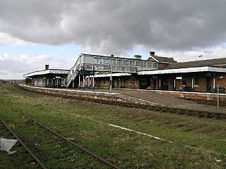
Sleaford railway station serves the town of Sleaford in Lincolnshire, England. It lies on the Peterborough–Lincoln line. The station is 21 miles (34 km) south of Lincoln Central.
Kirkby la Thorpe is a village and civil parish in North Kesteven district of Lincolnshire, England.The population at the 2011 census was 1,120. It lies 1.5 miles (2.4 km) east from Sleaford. The village is near the start of the A17 Sleaford bypass.
North Kesteven District Council in Lincolnshire, England is elected every four years.
Carre's Grammar School is a selective secondary school for boys in Sleaford, a market town in Lincolnshire, England.
Kesteven and Sleaford High SchoolSelective Academy, commonly known as Kesteven and Sleaford High School (KSHS), is a selective school with academy status in Sleaford, an English market town in Lincolnshire. It caters for girls aged between eleven and sixteen in Years 7 to 11, and girls and boys aged sixteen to eighteen in its coeducational Sixth Form.
Great Hale is a village and civil parish in the North Kesteven district of Lincolnshire, England. The population of the civil parish at the 2011 census was 778. It is situated on the B1394 road, immediately south from Heckington and 1.7 miles (2.7 km) north from Helpringham.
Heckington is a village and civil parish in the North Kesteven district of Lincolnshire, England. It is situated between Sleaford and Swineshead Bridge, and south of the A17 road. Heckington, with 1,491 households, is one of the largest villages in Lincolnshire. The population of the civil parish including Boughton was 3,353 at the 2011 census.
Silk Willoughby is a village and civil parish in the North Kesteven district of Lincolnshire, England. The population of the civil parish at the 2011 census was 299. It is situated 2 miles (3 km) south from Sleaford.
The Sleaford Navigation was a 12.5-mile (20.1 km) canalisation of the River Slea in Lincolnshire, England, which opened in 1794. It ran from a junction with the River Witham, near Chapel Hill to the town of Sleaford through seven locks, most of which were adjacent to mills. Lack of finance meant that it stopped short of its intended terminus, but it gradually grew to be successful financially. The coming of the railways in 1857 led to a rapid decline, and it was officially abandoned by an act of Parliament in 1878, but remained open for a further three years. The lower part of it remained navigable until the 1940s, when it was blocked by a sluice.
Sleaford Joint Sixth Form (SJSF) is a partnership in Sleaford, England, between Carre's Grammar School, Kesteven and Sleaford High School and St George's Academy. It enables sixth-formers based at them to study individual courses offered at any of the schools. This makes provision more economical and gives students a choice of approximately 60 A-Level or Level 3 vocational courses.
Quarrington is a village and former civil parish, now part of the civil parish of Sleaford, in the North Kesteven district of Lincolnshire, England. The old village and its church lie approximately 1 miles (2 km) south-west from the centre of Sleaford. Suburban housing developments at New Quarrington and Quarrington Hill effectively link the two settlements. Bypassed by the A15, it is connected to Lincoln and Peterborough, as well as Newark and King's Lynn. At the 2011 census, Quarrington and Mareham ward, which incorporates most of the settlement, had an estimated population of 7,046.
St Denys' Church is a medieval Anglican parish church in Sleaford, Lincolnshire, England. While a church and a priest have probably been present in the settlement since approximately 1086, the oldest parts of the present building are the tower and spire, which date to the late 12th and early 13th centuries; the stone broach spire is one of the earliest examples of its kind in England. The Decorated Gothic nave, aisles and north transept were built in the 14th century. The church was altered in the 19th century: the north aisle was rebuilt by the local builders Kirk and Parry in 1853 and the tower and spire were largely rebuilt in 1884 after being struck by lightning. St Denys' remains an active parish church.
Holdingham is a hamlet in the civil parish and built-up area of Sleaford, in the North Kesteven district of Lincolnshire, England. It is bisected by Lincoln Road (B1518) which joins the A17 and A15 roads immediately north of the settlement; those roads connect it to Lincoln, Newark, Peterborough and King's Lynn. Sleaford railway station is on the Nottingham to Skegness and Peterborough to Lincoln Lines.
Sleaford – historically called New Sleaford – is a market town in the North Kesteven district of Lincolnshire, England. There are 181 listed buildings in the civil parish of Sleaford, which, along with the town, incorporates the village of Quarrington, the hamlet of Holdingham and the former ancient parish of Old Sleaford. One of the buildings is classified by Historic England as being in Grade I, six in Grade II* and 174 in Grade II.
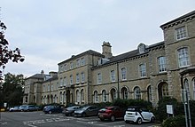
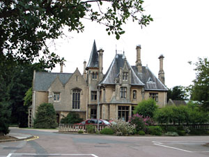
Westholme House is a historic building in the English market town of Sleaford in Lincolnshire, set in 32 acres of parkland and school grounds. Built around 1849 in the style of a French Gothic mansion by Charles Kirk for his business partner Thomas Parry, it was privately owned until the 1940s, when Kesteven County Council acquired the house and its grounds. It subsequently served as the county library and part of Sleaford Secondary Modern School. The stone house follows an asymmetrical layout and incorporates a range of Gothic elements in its design. In 1974, it was recorded in the National Heritage List for England as a designated Grade II listed building, recognising it as of "special interest".
St Botolph's Church is an Anglican church in Quarrington in Lincolnshire, England.
References
Notes
↑ Much of the gold and bronze found in the cemetery was deposited in the British Museum after it was uncovered in the 1880s by the excavator George Thomas.[32]
↑ The Bishop succeeded a Saxon thegn, Bardi, and held 11 carucates with 29 villeins, 11 borders, 6 sokeman, a church and priest, and 8 mills, 1 acre (0.4 hectares) of woodland, 320 acres (130 hectares) of meadow and 330 acres (130 hectares) of marsh. Ramsey Abbey had been granted land in Sleaford and surrounding villages in about 1051. By Domesday its fee called Eslaforde consisted of 1 carucate, 1 sokeman, 2 villeins and 27 acres (11 hectares) of meadow; it was sokeland of the abbot of Ramsey's manor of Quarrington, where he is recorded holding two churches.[34]
↑ This hypothesis was based on the topography, the granting of a fair, market and burgage tenure in the 12th century, and the "Old" and "New" epithets[39]
↑ The earliest references to Old and New Sleaford occur in 13th century documents, which limits their use as evidence for town plantation; the grants of a market and fair in the 12th century do not necessarily indicate a new settlement, but merely a codification and rationalisation of pre-existing arrangements. The diversion of roads like Mareham Lane and the compass-aligned streets provide no chronology even if they imply a westward migration from Old Sleaford.[41]
↑ Bricks could also be transported more easily, which contributed to the construction of new buildings on West Banks, Grantham Road and London Road (Ellis 1981, p. 87). For a full account of the development of West Banks and adjoining roads, see Ellis 1981, pp. 51–65. Station Road and Nag's Head Passage were also developed in this period (Ellis 1981, pp. 68–69).
↑ The principle buildings were the Sessions House (1831), the grammar school (1834), Carre's Hospital (1830–1846), the gasworks (1839), Navigation House (1838–39), much of Eastgate (including the Alvey School in 1850, and Kingston and Lafford Terraces in 1856 and 1857), the cemetery (1856) and the corn exchange (1857)
↑ Playhouse Yard, Charles Street, Leicester Street and Cabbage Row being four main examples.[86]
↑ These figures relate to the area of the Sleaford civil parish as defined in 1974. For the years before 1974, they relate to the civil parish's predecessor, the Sleaford Urban District, which existed between 1894 and 1974. For the years before 1894, they are the sum of the resident populations of the ancient/civil parishes of New Sleaford, Old Sleaford, Quarrington and (after it was separated from New Sleaford in 1866) Holdingham.
↑ Figures for 1801–1901, except 1861 and 1871, are taken from:
The figures for 1861 and 1871 are based on combining the populations for Old Sleaford, New Sleaford and Holdingham parishes, as recorded in Census Office 1862, pp.517, 850 and Census Office 1873, pp.654, 685, 700, 710, 729
The figure for 2021 has been obtained by querying the PP002 Dataset from the 2021 Census via Nomis: Official Labour Market Statistics. Office for National Statistics. Retrieved 2 June 2024.
↑ These figures include Holdingham before 1866. The figures excluding Holdingham hamlet were: 1,483 (1801), 1,781 (1811), 2,094 (1821), 2,450 (1831), 3,184 (1841), 3,372 (1851),[112] and 3,325 (1861).[113]
↑ Proposals to link Sleaford to Ancaster for transporting stone in 1827 did not materialise; works by the Ambergate Company in the 1840s should have extended to Sleaford, but stopped at Grantham in 1850, while opposition from the Navigation Company to another proposal further delayed railway links to the town.[142]
↑ Sleaford Poor Law Union consisted of the following parishes: Anwick, Asgarby, Ashby de la Launde, Aswarby, Aunsby, Byard's Leap (1861–1930), Billinghay, Blankney, Bloxholm, Brauncewell, Burton Pedwardine, Cranwell, Culverthorpe, Dembleby, Digby, Dogdyke (c. 1894–1930), Dorrington, Evedon, Ewerby, Great Hale, Little Hale, Haverholme Priory (1861–1930), Heckington, Helpringham, Holdingham, Howell, Kelby, Kirkby Green, Kirkby la Thrope, North Kyme, South Kyme, Leadenham, Leasingham, Martin, Newton, Osbournby, Quarrington, North Rauceby, South Rauceby, Rowston, Roxholm, Ruskington, Scredington, Scopwick, New Sleaford, Old Sleaford, Spanby, Swarby, Swaton, Temple Bruer with Temple High Grange (1861–1930), Thorpe Tillney, Threckingham, Timberland, Walcot (near Billinghay), Walcot (near Folkingham), Welbourn, Wellingore, Scott Willoughby, Silk Willoughby, Wilsford.[155]
↑ To cope with rising numbers of pupils (largely as a result of the housing developments being built around the town), the original school building was extended in 1976; the old schoolhouse was refurbished in 1988, while replacement classrooms were completed for part of the school in 1994 following a fire; further extensions were opened in 1995 and 1997.[199]
↑ In the Compton Census (1676), New Sleaford had a Conformist population of 576 people, no "Papists" and 6 Non-conformists.[244] In the 19th century, it had a sizeable Non-conformist population and a large Anglican congregation; at the 1851 Census of Religious Worship, an estimated 2,000 people attended Non-conformist places of worship, while an estimated 600–700 people attended Anglican services in the parish.[243] The Wesleyans met in Westgate in the early 19th century; by 1848, the congregation had set up in Northgate, an area known for its taverns and poor tenements.[245]
↑ After his death, Cornelius Greenwood wrote and published a biography of him, entitled A short account of the late Mr. Thomas Fawcett: to which is added, the rise and progress of Methodism in Sleaford (1839). The work was listed in Stampe, George (1896). "List of Local Histories". Proceedings of the Wesley Historical Society. 1 (1): 12. and has an OCLC number of 28682597.
Citations
↑ "Sleaford". City population. Retrieved 25 October 2022.
↑ "Archive Listings 721–740". Lincolnshire Film Archive (ARCHON directory code 2929). Retrieved 7 January 2015. See no. 732 ("Building the A17 Bypass"), on standard 8mm colour film, a sample of which is available on YouTube.
↑ "History – The Early Years". Sleaford Navigation Trust. Archived from the original on 29 November 2014. Retrieved 29 November 2014.{{cite web}}: CS1 maint: bot: original URL status unknown (link) Archived at the Internet Archive on .
↑ "Navigation Yard". The Sleaford Heritage Trail. Sleaford and District Civic Trust. Retrieved 21 November 2023.
↑ "Sleaford Local Board of Health". Stamford Mercury. 30 November 1877. p.6. Retrieved 21 November 2023. The District comprises the parishes of New Sleaford, Old Sleaford, Quarrington, and Holdingham...
↑ "Kesteven County Council". Stamford Mercury. 16 November 1900. p.6. Retrieved 21 November 2023. ...henceforth the name or style of the Urban District Council of New Sleaford and their district shall be respectively known as the "Sleaford Urban District Council" and the "Sleaford Urban District"...
↑ "Sleaford Urban District". A Vision of Britain through Time. GB Historical GIS / University of Portsmouth. Retrieved 21 November 2023.
↑ "Prospectus"(PDF). Church Lane Primary School. Archived from the original on 12 September 2014.{{cite web}}: CS1 maint: bot: original URL status unknown (link) Archived at the Internet Archive on .
↑ "Admissions Policy 2015"(PDF). St George's Academy. Archived from the original on 10 January 2015. Retrieved 7 January 2015.{{cite web}}: CS1 maint: bot: original URL status unknown (link) Archived at the Internet Archive on .
↑ Database of specialist schools in the United Kingdom in 2008, supplied by the Department for Education and Skills, as archived by the National Archives on 12 September 2008 (see also the index page).
↑ "Sleaford New Council Schools"(PDF). Sleaford Gazette and South Lincolnshire Advertiser. 9 May 1908. Archived from the original on 22 December 2009.{{cite news}}: CS1 maint: unfit URL (link)
↑ "Prebendaries: Lafford" in Diana E. Greenway (ed.), Fasti Ecclesiae Anglicanae 1066–1300, vol. 3 (London: Institute for Historical Research, 1977), pp. 73–74. Retrieved 12 September 2016.
↑ Neil R Wright (2016). Treading the Boards: Actors and theatres in Georgian Lincolnshire. SLHA. p.185.
↑ "History". Sleaford Playhouse. Archived from the original on 23 July 2014. Retrieved 13 September 2014.{{cite web}}: CS1 maint: bot: original URL status unknown (link) Archived at the Internet Archive on
↑ "Sleaford Cinema". Cinema Treasures. Archived from the original on 13 September 2014. Retrieved 13 September 2014.{{cite web}}: CS1 maint: bot: original URL status unknown (link) Archived at the Internet Archive on .
↑ "History". Sleaford Town FC. Archived from the original on 20 September 2013. Retrieved 21 August 2015.{{cite web}}: CS1 maint: bot: original URL status unknown (link) Archived at the Internet Archive on 20 September 2013.
↑ "History". Sleaford Golf Club. Archived from the original on 17 August 2014. Retrieved 11 September 2014.{{cite web}}: CS1 maint: bot: original URL status unknown (link) Archived at the Internet Archive on .
↑ "London Road, Sleaford". Cricket Archive. Archived from the original on 30 March 2014. Retrieved 11 September 2014.{{cite web}}: CS1 maint: bot: original URL status unknown (link) Archived at the Internet Archive on .
↑ "Sleaford Bristol Bowls Club". Lincolnshire County Council. Archived from the original on 11 September 2014. Retrieved 11 September 2014.{{cite web}}: CS1 maint: bot: original URL status unknown (link) Archived at the Internet Archive on .
↑ S. Harrison "Yerburgh, Robert Armstrong (1853–1916)"Oxford Dictionary of National Biography 2004 (online ed. October 2006). (Subscription or UK public library membership required)
↑ "Pattinson, Sir Robert" Who Was Who (A & C Black, an imprint of Bloomsbury Publishing plc. 1920–2015; online ed. Oxford University Press 2014) online ed. April 2014. (subscription required)
↑ C. Fell-Smith "Pickworth, Henry (c. 1673 – c. 1738)" rev. M.J. Mercer Oxford Dictionary of National Biography 2004. (Subscription or UK public library membership required)
↑ J. Blom and F. Blom "Austin, John (1613–1669)"Oxford Dictionary of National Biography 2004. (Subscription or UK public library membership required)
↑ C.L. Leachman "Scoffin, William (1654/5–1732)"Oxford Dictionary of National Biography 2004. (Subscription or UK public library membership required)
↑ B.W. Kirk "Fawcett, Benjamin (1715–1780)"Oxford Dictionary of National Biography 2004. (Subscription or UK public library membership required)
↑ E. Savage-Smith "Banister, Richard (c.1570–1626)"Oxford Dictionary of National Biography 2004. (Subscription or UK public library membership required)
↑ P. Curry "Andrews, Henry (1744–1820)"Oxford Dictionary of National Biography 2004. (Subscription or UK public library membership required)
↑ G. Goodwin "Jackson, Henry (1831–1879)" rev. M.A. Stephan Oxford Dictionary of National Biography 2004. (Subscription or UK public library membership required)
↑ C. M. P. Taylor "Smedley, Joseph (1784–1863)"Oxford Dictionary of National Biography 2004. (Subscription or UK public library membership required)
↑ A. McGown "Thompson, Eric Norman (1929–1982)"Oxford Dictionary of National Biography 2004 (online ed. September 2005). (Subscription or UK public library membership required)
Phillips, C. W. (July 1935). "Bronze Age sword from Lincolnshire". The Antiquaries Journal. 15 (3). London: The Society of Antiquaries: 300–301. doi:10.1017/s0003581500038269. S2CID162273475.
Fawcett, T. (1902), A History of the Free Churches of Sleaford from 1662 to 1902, Sleaford: Geo. G. Fawcett, OCLC55110324
Hosford, W. H. (1958). "The enclosure of Sleaford". Lincolnshire Associated Architectural Societies Report and Papers. 7: 83–90.
Pawley, S. (1992). "Democracy and proper drains: public health and landed influence in late-nineteenth-century Sleaford", Lincolnshire Past and Present, no. 7. (Society for Lincolnshire History and Archaeology)
This page is based on this Wikipedia article Text is available under the CC BY-SA 4.0 license; additional terms may apply. Images, videos and audio are available under their respective licenses.