Transport in Lincolnshire

Last updated

Lincolnshire is a large county in England with a sparse population distribution, which leads to problems funding all sorts of transport. The transport history is long and varied, with much of the road network still based on the Roman model, and the once extensive rail network a shadow of its former self.

Contents

Roads

Being on the economic periphery of England, Lincolnshire's transport links are less well developed than many other parts of the United Kingdom. The road network within the county is dominated by single-carriageway A roads and the minor B roads rather than motorways or dual carriageways – the administrative county of Lincolnshire is one of the small number of UK counties without a motorway (the M180, the principal link between South Yorkshire and the North Sea coast, runs exclusively within the boundaries of North Lincolnshire).


Three trunk roads are located in Lincolnshire, these are maintained by National Highways, a publicly owned company that is responsible for trunk routes across England. These are the A1, A46 & A52.


Following a north–south axis, the most important route into and out of the county is the A1 (formerly the Great North Road) linking the county with London and south-east England as well as the important population centres of northern England and Scotland. The A1 is entirely a dual carriageway in Lincolnshire.


The A46 reaches across the entire county, from Newark to Grimsby. The A46 is a trunk route between the county border near Newark to Lincoln, this section of road is almost entirely a Dual Carriageway, beyond Lincoln, the A46 is maintained by the local council and is entirely single carriageway. The A57 is entirely Single Carriageway in Lincolnshire, West of the A1 it is a trunk route, East of the A1 it is maintained by the local council.

Other important routes in Lincolnshire include the A15, A16, A17 & A158. The A15 & A16 run on the north–south axis, with the A16 being nearer to the East coast. The A15 lies between the A1 and A16. Both routes are almost entirely single carriageway with small amounts of dual carriageway in built up areas. The A17 & A158 run on the east–west axis; the A158 being located north of the A17. The A17 has the most rural dual carriageway distance of any of the roads in Lincolnshire, with Dual Carriageways being present at Beckingham, Sleaford & Holbeach.

Partly because of its fast and flat (but deceptively undulating) roads, Lincolnshire has one of the worst road accident records of the UK counties (as measured in terms of road fatalities per head of population). In a national effort to cut the number of speed-related deaths and injuries, the county's residents became early guinea pigs in a programme to roll out speed cameras across the country.

Bus

Bus services within the county are also limited in number, due to the inherent economic feasibility of serving a scattered population living across an area with low population density. Many smaller villages in the county have no regular bus service, making access to a private vehicle the only practical means of living in many parts of the county. The services that do exist almost exclusively serve the large population centres (e.g. Lincoln, Grantham, Boston, Skegness, Grimsby, Cleethorpes, Scunthorpe) and mid-sized market towns (e.g. Horncastle, Gainsborough) and a number of their dormitory and commuter villages.

The main bus company in the county, Stagecoach in Lincolnshire, was bought out by Stagecoach in late 2005. Stagecoach Grimsby-Cleethorpes runs buses in North East Lincolnshire

Smaller companies like the Delaine Buses and Kimes offer local services of considerable importance. A group of five of them offer integrated services under the InterConnect banner, including dial-up requested routings.

Rail

The low population density of the county means that the number of railway stations and train services is rather low considering the county's large physical size. A large number of the county's railway stations were permanently closed in the 1950s and 1960s, many following the Beeching Report of 1963.

An early closure (in 1959) was the whole of the former Midland and Great Northern Joint Railway line through Sutton Bridge, Spalding, and Bourne and west to the Midlands. No obvious alternative to this route was available, and the loss has affected development and caused road congestion ever since.

One of the first railways to close in Lincolnshire was the Earl of Ancaster's estate railway, which ran from the East Coast Main Line at Little Bytham, through the Grimsthorpe estate to Edenham. It operated until the 1870s. [1]

A daily through train service operated between Cleethorpes and London King's Cross via Grimsby, Market Rasen and Lincoln until 1993 when it was discontinued due to issues with the length of the platforms at Lincoln not being long enough for InterCity 125 trains. This necessitated passengers changing trains at Newark North Gate when travelling to or from the capital. However, the East Coast Main Line passes through the county and so it is possible to catch direct trains to London, Leeds or Edinburgh from Grantham. In December 2008 a daily East Midlands Trains service from Lincoln to London St Pancras, via Nottingham was introduced. In the summer of 2008, a major refit of Lincoln station improved signalling and customer facilities but did little to change the platform length issue.

TransPennine Express trains from Cleethorpes run to Manchester Airport, passing through Scunthorpe and connecting to the East Coast Main Line at Doncaster before continuing via Sheffield. East Midlands Railway services between Skegness and Nottingham pass through Boston, Sleaford and Grantham.

Stamford station is served hourly with an east–west CrossCountry service between Peterborough and Leicester.

An hourly East Midlands Railway service from Norwich to Liverpool stops at Grantham.

Airports

Lincolnshire has its own airport (Humberside Airport) in the north of the county at Kirmington (a former Royal Air Force bomber airfield), between Scunthorpe, Grimsby and Lincoln. Several others are fairly easily accessible by either road or rail.

Canals

Lincolnshire is served by the Foss Dyke canal, an ancient waterway of Roman origin, which connects the River Trent and the River Witham. Brayford Pool is the inland basin in the city, once a busy transhipment point. The Witham is navigable to Boston. Access between Brayford pool and the Witham is by the Glory Hole, a low medieval bridge spanning the river. The "Air Draught" under the bridge is given as 9 feet 2 inches.

The River Ancholme is also navigable with the Caistor Canal branch (now disused), as are some of the larger drains in the Fens, such as the South Forty-Foot Drain and the Witham Navigable Drains.

The Fens Waterways Link is a scheme for waterways improvement for leisure boating. It proposes a new navigation between the South Forty-Foot Drain and the River Witham. The new lock gates at Black Sluice in Boston were officially opened in March 2009. [2] Much work remains to be done on the Forty-foot before the dream can be realised of travelling from Lincoln to Cambridge.

The Horncastle Canal dates back to 1792, linking the town of Horncastle to the Witham and incorporating the route of the earlier Tattersal navigation. [3] At least a century before what is normally called the Canal Age the Stamford Canal and Louth Canal were in use with modern style locks and towpath construction. Bourne and Sleaford had navigable river access until well into the 20th century and there are plans afoot to re-open the Sleaford Navigation.

The Grantham Canal ran for 33 miles (53 km) from Grantham through 18 locks to West Bridgford, where it joined the River Trent. It is currently under restoration.

Related Research Articles

<span class="mw-page-title-main">Lincolnshire</span> County of England

Lincolnshire is a ceremonial county in eastern England. It is bordered by the East Riding of Yorkshire across the Humber estuary to the north, the North Sea to the east, Norfolk, Cambridgeshire, Northamptonshire and Rutland to the south, and Leicestershire, Nottinghamshire and South Yorkshire to the west. The county town is Lincoln.

<span class="mw-page-title-main">North East Lincolnshire</span> Borough in England

North East Lincolnshire is a unitary authority area with borough status in Lincolnshire, England. It borders the borough of North Lincolnshire and districts of West Lindsey and East Lindsey. The population of the district in the 2011 Census was 159,616. The administrative centre and largest settlement is Grimsby and the borough includes the towns of Cleethorpes and Immingham as well as the villages of New Waltham, Waltham, Humberston, Healing and Great Coates. The borough is also home to the Port of Grimsby and Port of Immingham as well as Cleethorpes beach.

<span class="mw-page-title-main">A46 road</span> Road in England

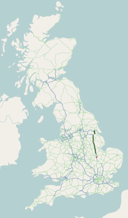
The A46 is a major A road in England. It starts east of Bath, Somerset and ends in Cleethorpes, Lincolnshire, but it does not form a continuous route. Large portions of the old road have been lost, bypassed, or replaced by motorway development. Between Leicester and Lincoln the road follows the course of the Roman Fosse Way, but between Bath and Leicester, two cities also linked by the Fosse Way, it follows a more westerly course.

<span class="mw-page-title-main">East Lindsey</span> Non-metropolitan district in England

East Lindsey is a local government district in Lincolnshire, England. The population of the district council was 142,300 at the 2021 census. The council is based in Horncastle having moved from its former headquarters at Manby in December 2022. Other major settlements in the district include Alford, Wragby, Spilsby, Holton le Clay, Mablethorpe, Skegness, Horncastle, Chapel St Leonards, Louth and Woodhall Spa. Skegness is the largest town in East Lindsey, followed by Louth.

<span class="mw-page-title-main">West Lindsey</span> District in England

West Lindsey is a local government district in Lincolnshire, England. Its council is based in Gainsborough and covers the towns of Market Rasen and Caistor, as well as the villages of Bardney, Saxilby, Morton, Hemswell Cliff, Scampton, Torksey, Cherry Willingham, Nettleham and Dunholme.

<span class="mw-page-title-main">A15 road (England)</span> Road in England

The A15 is a major road in England. It runs north from Peterborough via Market Deeping, Bourne, Sleaford and Lincoln along a variety of ancient, Roman, and Turnpike alignments before it is interrupted at its junction with the M180 near Scawby. The road restarts 10 miles (16 km) east, and then continues north past Barton-upon-Humber, crossing the Humber on the Humber Bridge before terminating at Hessle near Kingston upon Hull.

<span class="mw-page-title-main">A52 road</span> Major road in the East Midlands of England

The A52 is a major road in the East Midlands, England. It runs east from a junction with the A53 at Newcastle-under-Lyme near Stoke-on-Trent via Ashbourne, Derby, Stapleford, Nottingham, West Bridgford, Bingham, Grantham, Boston and Skegness to the east Lincolnshire coast at Mablethorpe. It is approximately 147 miles (237 km) long.

<span class="mw-page-title-main">A17 road (England)</span> Road in England

The A17 road is a mostly single carriageway road linking Newark-on-Trent in Nottinghamshire, England, to King's Lynn in Norfolk. It stretches for a distance of 62 miles travelling across the flat fen landscapes of southern Lincolnshire and western Norfolk and links the East Midlands with East Anglia. The road is notable for its numerous roundabouts and notoriously dangerous staggered junctions and also for its most famous landmark, the Cross Keys Bridge at Sutton Bridge close to the Lincolnshire/Cambridgeshire/Norfolk borders which carries the road over the River Nene.

<span class="mw-page-title-main">A18 road (England)</span> Road in England

The A18 is a road in England that links Doncaster in South Yorkshire with Ludborough in Lincolnshire, via Scunthorpe and Grimsby. Much of its route has been superseded by the M180 motorway.

<span class="mw-page-title-main">Sleaford railway station</span> Railway station in Lincolnshire, England

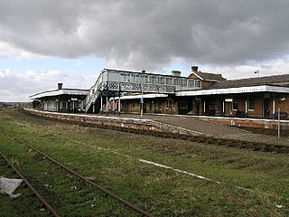
Sleaford railway station serves the town of Sleaford in Lincolnshire, England. It lies on the Peterborough–Lincoln line. The station is 21 miles (34 km) south of Lincoln Central.

<span class="mw-page-title-main">Viking Way</span> 147 mile footpath in England

The Viking Way is a long distance trail in England running 147 miles (237 km) between the Humber Bridge in North Lincolnshire and Oakham in Rutland.

<span class="mw-page-title-main">A180 road (England)</span> Road in northern England

The A180 is a primary route in northern England, that runs from the M180 motorway to Cleethorpes. The road is a continuation of the M180, but built to lower specifications: it is mainly dual two-lane without hard shoulders. The road is dual carriageway for 16.87 miles (27.15 km) from the M180 to Grimsby, and is a single carriageway road for 2 miles (3.2 km) between Grimsby and Cleethorpes beach.

<span class="mw-page-title-main">Lincolnshire coast</span> Part of the English coastline

The coast of Lincolnshire runs for more than 50 miles (80 km) down the North Sea coast of eastern England, from the estuary of the Humber to the marshlands of the Wash, where it meets Norfolk. This stretch of coastline has long been associated with tourism, fishing and trade.

<span class="mw-page-title-main">Stagecoach Grimsby-Cleethorpes</span> Bus operator in North East Lincolnshire, England

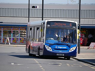
Stagecoach Grimsby-Cleethorpes is a subdivision of Stagecoach East Midlands that operates buses in and around North East Lincolnshire, England, serving a population of over 150,000. It runs town services in its main hubs of Grimsby and Cleethorpes, as well as services to Immingham and nearby villages.

<span class="mw-page-title-main">A153 road</span> Road in Lincolnshire, England

The A153 is a non-primary A road entirely in Lincolnshire in the east of England.

<span class="mw-page-title-main">A158 road</span> Road in England

The A158 road is a major route that heads from Lincoln in the west to Skegness on the east coast. The road is located entirely in the county of Lincolnshire and is single carriageway for almost its entirety. The road is approximately 40 miles (64 km) long. The road gets quite congested with holiday traffic during the summer.

<span class="mw-page-title-main">A607 road</span> Road in England

The A607 is an A road in England that starts in Belgrave, Leicester and heads northeastwards through Leicestershire and the town of Grantham, Lincolnshire, terminating at Bracebridge Heath, a village on the outskirts of Lincoln. It is a primary route from Thurmaston to the A1 junction at Grantham.

<span class="mw-page-title-main">Lincoln City Centre</span> Central business district in England

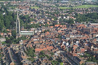
Lincoln City Centre is the central business district of Lincoln in Lincolnshire, England. It is defined as the areas along directly north of city's High Street. Each part of the centre brings a differing main sector or sectors to the city with a small overlap between each area.

References

  1. Pearson, R. E & Ruddock, J. G. Lord Willoughby's Railway (Willoughby Memorial Trust. 1986)
  2. "New lock project officially open". 20 March 2009. Retrieved 7 April 2018 via news.bbc.co.uk.
  3. J.N. Clarke, The Horncastle and Tattershall Canal (Oakwood Press, 1990)