Sloatsburg station

Last updated

Sloatsburg
Sloatsburg, NY, train station looking north.jpg
Sloatsburg station platform, looking north
General information
LocationMunicipal Plaza & Mills Street
Sloatsburg, New York
Coordinates 41°09′26″N74°11′29″W / 41.1572°N 74.1913°W / 41.1572; -74.1913
Owned by Metro-North Railroad
Line(s) NS Southern Tier Line
Platforms1 side platform
Tracks1
Connections
Construction
Structure typeAt-grade
Parking80 spaces [1]
AccessibleNo [1]
Other information
Station code2509 (Erie Railroad) [2]
History
Opened1868 (1868) (Erie Railroad)
Services
Preceding station MTA NYC logo.svg Metro-North Railroad Following station
Tuxedo
toward Port Jervis
Port Jervis Line Suffern
toward Hoboken
Former services
Preceding station Erie Railroad Following station
Tuxedo
toward Chicago
Main Line Sterlington
toward Jersey City
Location
Sloatsburg station

Sloatsburg station is a commuter rail stop owned by Metro-North Railroad serving trains on the Port Jervis Line, located in the village of Sloatsburg, New York at the intersection of Municipal Plaza and Mills Street. [3]

Contents

Construction of the Sloatsburg station dates back to the 1830s, when the station was built along the Erie Railroad. The station served the line heading to Port Jervis northward, along with a stagecoach to Greenwood Lake three times a day. The station was populated by fishermen on their way to the lake, but has been the site of several accidents. These calamities include a derailed milk train in 1843 and a fatal accident between the train line and several mules and their owner in 1855. The station became part of Metro-North in 1983, when the service was created. The station was listed under a revitalization plan in 2005 to help serve its commuters.

History

The former station depot at Sloatsburg, circa 1907-1912 Sloatsburg station - Bailey.jpg
The former station depot at Sloatsburg, circa 19071912

The Erie Railroad was constructed through Sloatsburg from 1836 to 1841, helping with the prosperity of the village, along with its population. [4] The station was also near the Sterlington one, but it never served of great importance. [5] The Sloatsburg station building was built in 1868 as a two-story brick facade with a tin roof. The style of the building, according to the railroad's 1920 engineering report, is a Type 6A style, with dimensions of 17' x 29.5' x 19'. The station was equipped to host as a base for XG Radio from the Suffern Tower (SF) in Suffern. [6] The Sloatsburg station served well for the nearby Greenwood Lake, with a stagecoach leaving the station three times day. The stagecoach was mainly inhabited by fishermen on their way to Greenwood Lake. [7]

The station has been the site of several major accidents involving locomotives. In 1843, the Sloatsburg station was the site of a large accident by train full of milk bottles. [8] On December 31, 1855, the railroad's Cincinnati Express was thrown off the tracks near the Sloatsburg station, when it tried to avoid a countrymen and his four mules, who were crossing the tracks. Three of the mules were killed and mutilated by the train, while the fourth died soon after. There was no damage to the cars or injuries to the passengers. [9] In the early days of August 1856, a girl by the name of McGraff was injured by an oncoming train near the station after carelessly walking onto the tracks. The parents, who were in a poor state financially, was given $45 (1856 USD) in return for their troubles from the Board of Directors in nearby Goshen. [10] On February 21, 1858, a train heading southbound experienced an accident when a brakeman, John Freeland, fell off the train and was run over. Freeland's legs were severed in the incident, and one arm was broken. They hurried Freeland southbound on a nearby train, but died by the time the train reached Paterson, New Jersey towards the hospital. [11]

Brown Estate gateposts Brown Estate gateposts.jpg
Brown Estate gateposts

The station is also close to the original entrance gate to Sloatsburg's Cappamore Farm. The house in the nearby mountainside was built around 1900 as an estate for Nicholas T. Brown, a local alderman from Paterson, New Jersey. [12] This estate and farm gave a panoramic view of the countryside around Sloatsburg. The house was demolished during the construction of the New York State Thruway in 1956. The steel bridge over the Ramapo River and the wooden bridge over Sloat's Millrace were removed as they had become hazardous. Today, all that remains are the stone pillar entranceway, and a walking trail to the nearby Sloat's Dam. [13] The gateposts are listed on the National Register of Historic Places along with the remaining mill and dam structures since they used the same stonework. [14]

In 2005, the Metropolitan Transportation Authority announced plans to renovate the train station. This, along the village's plans to revitalize the entire village of Sloatsburg, was thought to give the bland train station a more traditional look. This would include adding a roof to protect commuters and visitors from the elements, such as rain or snow, handicap-accessible ramps for wheelchairs, better lighting, more seats for people to wait, and a heated shelter. (A shelter exists, but is not heated). The village also wants to use a $50,000 grant from the state to construct a large municipal parking lot near the station. This would get more people to use the station, as because with the lack of facilities, the station is under-used. The preliminary design was made by Jeff Livingston, an architect on the Sloatsburg Revitalization Committee. [15]

Station layout

The station has one track and a short concrete low-level side platform, and is located just south of a grade crossing. The station platform has a shelter and one ticket machine. The station's parking lot, located near a hardware store on Mills Street, has 80 parking spaces. The station is operated by the village of Sloatsburg instead of Metro-North. [16] Connections are available to Transport of Rockland Route 93 and Short Line Bus Routes 17M and 17MD. [17] [18]

Sloatsburg station serves numerous hiking trails in Harriman State Park and Bear Mountain State Park. [19]

Related Research Articles

<span class="mw-page-title-main">Rockland County, New York</span> County in New York, United States

Rockland County is the second-southernmost county on the west side of the Hudson River in the U.S. state of New York, after Richmond County. It is part of the New York metropolitan area. As of the 2020 U.S. census, the county's population is 338,329, making it the state's third-most densely populated county outside New York City after Nassau and neighboring Westchester Counties. The county seat and largest hamlet is New City. Rockland County is accessible via the New York State Thruway, which crosses the Hudson to Westchester at the Tappan Zee Bridge ten exits up from the NYC border, as well as the Palisades Parkway five exits up from the George Washington Bridge. The county's name derives from "rocky land", as the area has been aptly described, largely due to the Hudson River Palisades. The county is part of the Hudson Valley region of the state.

<span class="mw-page-title-main">Harriman, New York</span> Village in New York, United States

Harriman is a village in Orange County, New York, United States. It is in the southeastern section of the town of Monroe, with a small portion in the town of Woodbury. The population was 2,714 at the 2020 census. It is part of the Kiryas Joel–Poughkeepsie–Newburgh, NY Metropolitan Statistical Area as well as the larger New York–Newark–Bridgeport, NY-NJ-CT-PA Combined Statistical Area.

<span class="mw-page-title-main">Sloatsburg, New York</span> Village in Ramapo, New York, US

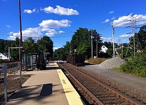
Sloatsburg is a village in the town of Ramapo in Rockland County, New York, United States. Located east of Orange County, it is at the southern entrance to Harriman State Park. The population was 3,036 at the 2020 census. The village is named after Stephen Sloat, an early European landowner.

<span class="mw-page-title-main">Suffern, New York</span> Village in New York, United States

Suffern is a village that was incorporated in 1796 in the town of Ramapo in Rockland County, New York. Sitting adjacent to the town of Mahwah, New Jersey, Suffern is located 31 miles northwest of Manhattan. As of the 2020 census, Suffern's population was 11,402.

<span class="mw-page-title-main">Pascack Valley Line</span> Commuter rail line in New Jersey and New York

The Pascack Valley Line is a commuter rail line operated by the Hoboken Division of New Jersey Transit, in the U.S. states of New Jersey and New York. The line runs north from Hoboken Terminal, through Hudson and Bergen counties in New Jersey, and into Rockland County, New York, terminating at Spring Valley. Service within New York is operated under contract with Metro-North Railroad. The line is named for the Pascack Valley region that it passes through in northern Bergen County. The line parallels the Pascack Brook for some distance. The line is colored purple on system maps, and its symbol is a pine tree.

<span class="mw-page-title-main">Main Line (NJ Transit)</span> Commuter rail line in New Jersey

The Main Line is a commuter rail line owned and operated by New Jersey Transit running from Suffern, New York to Hoboken, New Jersey, in the United States. It runs daily commuter service and was once the north–south main line of the Erie Railroad. It is colored yellow on NJ Transit system maps, and its symbol is a water wheel.

<span class="mw-page-title-main">NJ Transit Rail Operations</span> Commuter rail division of NJ Transit

NJ Transit Rail Operations is the rail division of NJ Transit. It operates commuter rail service in New Jersey, with most service centered on transportation to and from New York City, Hoboken, and Newark. NJ Transit also operates rail service in Orange and Rockland counties in New York under contract to Metro-North Railroad. The commuter rail lines saw 57,179,000 riders in 2023, making it the third-busiest commuter railroad in North America and the longest commuter rail system in North America by route length.

<span class="mw-page-title-main">Bergen County Line</span> Commuter rail line in New Jersey

The Bergen County Line is a commuter rail line and service owned and operated by New Jersey Transit in the U.S. state of New Jersey. The line loops off the Main Line between the Meadowlands and Glen Rock, with trains continuing in either direction along the Main Line. It is colored on NJT system maps in grey, and its symbol is a cattail, which are commonly found in the Meadowlands where the line runs.

<span class="mw-page-title-main">Port Jervis Line</span> Commuter rail line in New York

The Port Jervis Line is a predominantly single-track commuter rail line running between Suffern and Port Jervis, in the U.S. state of New York. At Suffern, the line continues south into New Jersey on NJ Transit's Main Line. The line is operated by NJ Transit Rail Operations under a contract with Metro-North Railroad (MNRR).

<span class="mw-page-title-main">Salisbury Mills–Cornwall station</span> Metro-North Railroad station in New York

Salisbury Mills–Cornwall station is a commuter rail stop owned by Metro-North Railroad serving trains on the Port Jervis Line, located in the Beaver Dam Lake section of the town of Cornwall, New York. The station is located at the northern end of the Moodna Viaduct, accessible from NY 94.

<span class="mw-page-title-main">Suffern station</span> NJ Transit and Metro-North Railroad station

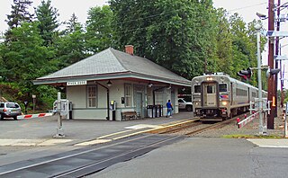
Suffern station is a railroad station in the village of Suffern. The station, located on Ramapo Avenue in Suffern, services trains of New Jersey Transit's Main Line and Metro-North Railroad's Port Jervis Line. Suffern station serves as the terminal for Main Line trains, as trains continue north into Hillburn Yard. The next Main Line station, located in New Jersey, is Mahwah. The next Port Jervis Line station to the north is Sloatsburg. The station consists of two low-level side platforms for trains in both directions, neither of which are handicap accessible for the Americans with Disabilities Act of 1990.

<span class="mw-page-title-main">Nanuet station</span> Metro-North Railroad station in New York

Nanuet station is a train station in Nanuet, New York, serving commuter trains on the Pascack Valley Line. Its official address is 1 Prospect Street, but in reality, it is located on Orchard Street West, diagonally off the southwest corner of Prospect Street and Middletown Road.

<span class="mw-page-title-main">Spring Valley station (New York)</span> Metro-North Railroad station in New York

Spring Valley station is an intermodal transit station in Spring Valley, New York. It serves commuter trains as well as buses as the Spring Valley Bus Terminal. The buses that serve the Spring Valley Bus Terminal are Rockland Coaches, Hudson Link, and Transport of Rockland. It is located on Main Street (Route 45), 0.125 miles (0.201 km) from Route 59.

<span class="mw-page-title-main">Hawthorne station (NJ Transit)</span> NJ Transit rail station

Hawthorne is an active commuter railroad station operated by New Jersey Transit in the borough of Hawthorne, Passaic County, New Jersey, United States. It is the northernmost station in Passaic County along New Jersey Transit's Main Line. Trains coming through Hawthorne service Waldwick, Suffern and Port Jervis to the north and Hoboken Terminal to the south, where connections are available to New York City via Port Authority Trans-Hudson and ferries. The station, accessible only by Washington Place in Hawthorne, contains only two low-level platforms connected by a grade crossing. As a result, the station is not compliant with the Americans with Disabilities Act of 1990.

<span class="mw-page-title-main">Allendale station (NJ Transit)</span> NJ Transit rail station

Allendale is a NJ Transit rail station served by its Main and Bergen County lines as well as Port Jervis Line trains. The station is located at the railroad next to Allendale, Park and Myrtle avenues in Downtown Allendale. The station consists of two low-level platforms serving trains heading between Hoboken Terminal and Suffern. Some westbound trains headed for Port Jervis also stop at Allendale. The station has two ticket vending machines along the inbound platform with three parking lots for commuters. The railroad depot, constructed in 1870, is a combined passenger and freight depot, with a waiting area for passengers at the south end of the building while the northern end is unused.

<span class="mw-page-title-main">Mahwah station</span> NJ Transit and Metro-North Railroad station

Mahwah station is a NJ Transit train station located in Mahwah, New Jersey served by the Main Line, Bergen County Line and a limited service served by Metro-North Railroad's Port Jervis Line.

Sterlington, was a tiny community located in the Town of Ramapo, Rockland County, New York, United States located between Suffern and Sloatsburg.

<span class="mw-page-title-main">Sloat's Dam and Mill Pond</span> United States historic place

Sloat's Dam and Mill Pond is located between Waldron Terrace and Ballard Avenue in Sloatsburg, New York, United States. The 200-foot–long concrete dam creates the mill pond north of it by impounding the Ramapo River.

The recorded history of Rockland County, New York begins on February 23, 1798, when the county was split off from Orange County, New York and formed as its own administrative division of the state of New York. It is located 6 miles (9.7 km) north-northwest of New York City, and is part of the New York Metropolitan Area. The county seat is the hamlet of New City. The name comes from rocky land, an early description of the area given by settlers. Rockland is New York's southernmost county west of the Hudson River. It is suburban in nature, with a considerable amount of scenic designated parkland. Rockland County does not border any of the New York City boroughs, but is only 9.5 miles (15.3 km) north of Manhattan at the counties' two respective closest points

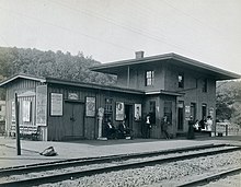
The 1958 Sterlington railroad disaster was a head-on collision by two Erie Railroad trains on August 11, 1958 at 6:47 AM killing 5 people and injuring 22 to 36. The collision occurred when the operator in the signal tower at Suffern failed to hold the westbound train No. 53 at Suffern for the eastbound No. 50 commuter train from Monroe, New York, to Hoboken, New Jersey. When he realized his error, he attempted to contact the crews via radio but was unsuccessful due to a radio dead spot. The trains impacted head-on right in front of the now abandoned Erie Railroad depot in Sterlington, New York near Sloatsburg, killing the crew of the locomotive No. 859 from train No.50 as well as two passengers and injuring the crew of the locomotive No. 1402 from the westbound train.

References

  1. 1 2 "Otisville station". Metro-North Railroad . Retrieved July 7, 2023.
  2. "List of Station Names and Numbers". Jersey City, New Jersey: Erie Railroad. May 1, 1916. Retrieved November 23, 2010.
  3. Sloatsburg Train Station Details. Metropolitan Transportation Authority. 2009.
  4. Kuykendall, Eugene L. (1998). Historic Sloatsburg, 1738-1998, The Way it Was, Is and Can Be. Sloatsburg Historical Society.
  5. Mott, Edward Harold (1899). Between the Ocean and the Lakes--The Story of the ERIE.
  6. Yanosey, Robert J. (2006). New York. Erie Railroad Facilities in Color. Vol. 2: NY. Scotch Plains, New Jersey: Morning Sun Books. p. 13. ISBN   1-58248-196-2.
  7. Hedden, Josiah; et al. (1864). The Erie Railway and its Branches. New York: Taintor Brothers and Company.
  8. "The First Sunday Train". The New York Times . August 12, 1900.
  9. "Railroad Accident and Narrow Escape". The New York Times. December 31, 1855.
  10. Mott, Edward Harold (1908). Between the Ocean and the Lakes: The Story of Erie. Ticker Company. p.  424. Sloatsburg NY Erie station.
  11. "Accident on the New York and Erie Railroad". The New York Times. February 22, 1858. p. 5.
  12. "MRS. NICHOLAS T. BROWN.; The Wife of the Alderman Dies Suddenly While Being Examined by a Doctor". The New York Times. October 10, 1897. p. 5.
  13. The Sloatsburg Historical Society historical sign located next to the Sloatsburg station and Stone Pillars denotate the history of the structure
  14. Bonafide, John (November 1999). "National Register of Historic Places nomination, Sloat's Dam and Mill Pond". New York State Office of Parks, Recreation and Historic Preservation. Archived from the original on May 17, 2012. Retrieved March 14, 2009.
  15. Beg, Sulaiman (June 8, 2005). "New life sought for old train station". The Journal News.
  16. "Sloatsburg Station". Rockland County, New York. 2009. p. 1. Retrieved January 5, 2009.
  17. "Route 93" (PDF). Transport of Rockland. Transport of Rockland. 2009. p. 2. Retrieved January 5, 2009.
  18. Route 17M/17MD Brochure. CoachUSA ShortLine. 2009.
  19. "Walk a Mile in Your Shoes..." Metropolitan Transportation Authority. 2009. Archived from the original on April 24, 2008. Retrieved January 4, 2009.