Snowville, Utah

Last updated
Snowville, Utah
Box Elder County Utah incorporated and unincorporated areas Snowville highlighted.svg
Location in Box Elder County and the state of Utah.
Map of USA UT.svg
Location of Utah in the United States
Coordinates: 41°58′14″N112°42′33″W / 41.97056°N 112.70917°W / 41.97056; -112.70917 Coordinates: 41°58′14″N112°42′33″W / 41.97056°N 112.70917°W / 41.97056; -112.70917
Country United States
State Utah
County Box Elder
Settled1871
Incorporated November 6, 1933
Named for Lorenzo Snow
Government
  TypeCouncil - Mayor Orlando Scott O'Hare
Area
[1]
  Total1.55 sq mi (4.02 km2)
  Land1.55 sq mi (4.02 km2)
  Water0.00 sq mi (0.00 km2)
Elevation
[2]
4,547 ft (1,386 m)
Population
 (2010)
  Total167
  Estimate 
(2019) [3]
173
  Density111.40/sq mi (43.01/km2)
Time zone UTC-7 (Mountain (MST))
  Summer (DST) UTC-6 (MDT)
ZIP code
84336
Area code 435
FIPS code 49-69970 [4]
GNIS feature ID1432604 [2]

Snowville is a town in Box Elder County, Utah, United States. The population was 167 at the 2010 census.

Contents

Geography

Snowville is located at an elevation of 4,551 feet (1,387 m).

According to the United States Census Bureau, the town has a total area of 1.5 square miles (4.0 km2), all land.

Climate

According to the Köppen Climate Classification system, Snowville has a warm-summer continental climate (Dfb).

Climate data for Snowville, Utah, 1893–1991
MonthJanFebMarAprMayJunJulAugSepOctNovDecYear
Average high °F (°C)33.6
(0.9)
39.0
(3.9)
47.6
(8.7)
59.5
(15.3)
68.5
(20.3)
79.7
(26.5)
89.9
(32.2)
88.0
(31.1)
77.6
(25.3)
64.6
(18.1)
48.3
(9.1)
36.5
(2.5)
61.1
(16.2)
Average low °F (°C)9.6
(−12.4)
14.5
(−9.7)
22.1
(−5.5)
28.7
(−1.8)
35.9
(2.2)
42.1
(5.6)
49.8
(9.9)
48.1
(8.9)
38.3
(3.5)
29.0
(−1.7)
21.1
(−6.1)
12.3
(−10.9)
29.3
(−1.5)
Average precipitation inches (mm)1.10
(28)
0.78
(20)
1.12
(28)
1.18
(30)
1.64
(42)
1.08
(27)
0.60
(15)
0.68
(17)
0.78
(20)
0.95
(24)
1.13
(29)
1.05
(27)
12.09
(307)
Average snowfall inches (cm)9.1
(23)
4.9
(12)
3.5
(8.9)
1.0
(2.5)
0.2
(0.51)
0.0
(0.0)
0.0
(0.0)
0.0
(0.0)
0.0
(0.0)
0.1
(0.25)
3.8
(9.7)
5.5
(14)
28.0
(71)
Average precipitation days (≥ 0.01 in)65667533446662
Source: WRCC [5]

Demographics

Historical population
CensusPop.
1880 197
1890 175−11.2%
1900 1834.6%
1910 25639.9%
1920 249−2.7%
1930 34237.3%
1940 195−43.0%
1950 1992.1%
1960 159−20.1%
1970 1749.4%
1980 23736.2%
1990 2515.9%
2000 177−29.5%
2010 167−5.6%
2019 (est.)173 [3] 3.6%
U.S. Decennial Census [6]

As of the census [4] of 2000, there were 177 people, 59 households, and 46 families residing in the town. The population density was 115.4 people per square mile (44.7/km2). There were 71 housing units at an average density of 46.3 per square mile (17.9/km2). The racial makeup of the town was 88.70% White, 0.56% Asian, 9.60% from other races, and 1.13% from two or more races. Hispanic or Latino of any race were 19.21% of the population.

There were 59 households, out of which 47.5% had children under the age of 18 living with them, 62.7% were married couples living together, 10.2% had a female householder with no husband present, and 22.0% were non-families. 20.3% of all households were made up of individuals, and 10.2% had someone living alone who was 65 years of age or older. The average household size was 3.00 and the average family size was 3.52.

In the town, the population was spread out, with 29.9% under the age of 18, 15.3% from 18 to 24, 24.3% from 25 to 44, 20.3% from 45 to 64, and 10.2% who were 65 years of age or older. The median age was 28 years. For every 100 females, there were 96.7 males. For every 100 females age 18 and over, there were 96.8 males.

The median income for a household in the town was $24,375, and the median income for a family was $35,750. Males had a median income of $36,250 versus $35,250 for females. The per capita income for the town was $13,604. None of the families and 4.8% of the population were living below the poverty line, including no under eighteens and 54.5% of those over 64.

History

Curlew Valley Settler's Bell at the Snowville City Park. Curlew Valley.jpg
Curlew Valley Settler's Bell at the Snowville City Park.

Curlew Valley, named after the curlew snipe that nests there, extends from Snowville, Utah, to the Idaho towns of Stone and Holbrook. The first recorded settlers were Peter Skene Ogden's large party of trappers that camped on Deep Creek December 27, 1828.

Some of the discharged members of the Mormon Battalion, on their way home from California to Salt Lake City on September 18, 1848, camped on Deep Creek and also in a cave one mile (1.6 km) east called Hollow Rock.

The beginning of Deep Creek is a large spring at Holbrook which runs through the center of the valley and has never varied even in dry years. About one mile (1.6 km) southwest is Rocky Ford, where the pioneers were able to pass on solid rock.

In 1869, Joseph William Robbins , Thomas Showell, and William M. Harris settled at the Curlew Sinks, ten miles (16 km) west of here, where Deep Creek sinks into the ground. The old pioneer trail and the stage line went through their ranch.

The first townsite in the Curlew Valley was Snowville. Settled at the direction of Brigham Young, the community was named in honor of Lorenzo Snow, an apostle who became President of the Church of Jesus Christ of Latter-day Saints from 1898–1901.

Cemetery

Snowville Cemetery Memorial Day 2006 035.jpg
Snowville Cemetery

The Snowville Cemetery is located at 750 North 600 West in Snowville, Utah. The earliest burial was of William O'Donald, who died on May 27, 1869. As of 2004, there are 540 burials on 10 acres (40,000 m2) owned by the town of Snowville. Two unknown soldiers are buried in the cemetery as well as William Robbins, the first settler of the valley and a veteran of the American Civil War. The cemetery’s online database is maintained by the Utah History Research Center.

See also

Related Research Articles

<span class="mw-page-title-main">Box Elder County, Utah</span> County in Utah, United States

Box Elder County is a county at the northwestern corner of Utah, United States. As of 2018, the estimated population is 54,950. Its county seat and largest city is Brigham City. The county was named for the box elder trees that abound in the county.

<span class="mw-page-title-main">Oneida County, Idaho</span> County in Idaho, United States

Oneida County is a county located in the U.S. state of Idaho. As of the 2010 Census the county had a population of 4,286. The county seat and largest city is Malad City. Most of the county's population lives in Malad City and the surrounding Malad Valley.

<span class="mw-page-title-main">Ulm, Montana</span> CDP in Montana, United States

Ulm is a census-designated place (CDP) in Cascade County, Montana, United States. It was originally a large ranch owned by Indiana-born cattleman William Ulm. The population was 738 at the 2010 census. It is part of the Great Falls, Montana Metropolitan Statistical Area.

<span class="mw-page-title-main">Howell, Utah</span> Town in the state of Utah, United States

Howell is a town located in the Blue Creek Valley in northeast Box Elder County, Utah, United States. The population was 245 at the 2010 census.

<span class="mw-page-title-main">Portage, Utah</span> Town in Utah, United States

Portage is a town in Box Elder County, Utah, United States. The population was 245 at the 2010 census. The town received its name from Mormon apostle Lorenzo Snow. He named it Portage after his birthplace of Portage County, Ohio.

<span class="mw-page-title-main">Millville, Utah</span> City in Utah, United States

Millville is a city in Cache County, Utah, United States. The population was 2,222 at the 2020 census, with an estimated population of 2,300 in 2022. It is included in the Logan, Utah-Idaho Metropolitan Statistical Area.

<span class="mw-page-title-main">Castle Dale, Utah</span> City in Utah, United States

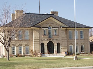
Castle Dale is a city in northwestern Emery County, Utah, United States. The population was 1,630 at the 2010 census. It is the county seat of Emery County.

<span class="mw-page-title-main">Clawson, Utah</span> Town in the state of Utah, United States

Clawson is a town in Emery County, Utah, United States. The population was 163 at the 2010 census. The community was named after Rudger Clawson, a Mormon leader.

<span class="mw-page-title-main">Antimony, Utah</span> Town in the state of Utah, United States

Antimony is a town in Garfield County, Utah, United States. The population was 122 at the 2010 census, the same as the 2000 census.

<span class="mw-page-title-main">Hatch, Utah</span> Town in the state of Utah, United States

Hatch is a town in Garfield County, Utah, United States. The population was 133 at the 2010 census. It is 260 miles (420 km) south of Salt Lake City.

<span class="mw-page-title-main">Levan, Utah</span> Town in Utah, United States

Levan is a town in Juab County, Utah, United States. As of the 2010 census it had a population of 841, and in 2018 the estimated population was 924.

<span class="mw-page-title-main">Nephi, Utah</span> City in Utah, United States

Nephi is a city in Juab County, Utah, United States. It is part of the Provo–Orem metropolitan area. The population was 6,443 at the 2020 census. It is the county seat of Juab County. It was settled by Mormon pioneers in 1851 as Salt Creek, and it acquired its current name in 1882. It is the principal city in the Juab Valley, an agricultural area. Nephi was named after Nephi, son of Lehi, from the Book of Mormon.

<span class="mw-page-title-main">Meadow, Utah</span> Town in the state of Utah, United States

Meadow is a town in Millard County, Utah, United States. The population was 254 at the 2000 census. Originally called Meadow Creek, the town is located about eight miles south of Fillmore.

<span class="mw-page-title-main">Centerfield, Utah</span> City in Utah, United States

Centerfield is a city in southwestern Sanpete County, Utah, United States. The population was 1,367 at the 2010 census. Although Centerfield was a town in 2000, it has since been classified as a fifth-class city by state law. The community was so named because of its location in the center of a wide valley.

<span class="mw-page-title-main">Ephraim, Utah</span> City in Utah, United States

Ephraim is a city in Sanpete County, Utah, United States. The population was 5,611 at the 2020 census, making it the largest city in Sanpete County. It is the location of Snow College and is located along U.S. Route 89.

<span class="mw-page-title-main">Vernon, Utah</span> Town in the state of Utah, United States

Vernon is a town in southeastern Tooele County, Utah, United States.

<span class="mw-page-title-main">Midway, Utah</span> City in Utah, United States

Midway is a city in northwestern Wasatch County, Utah, United States. It is located in the Heber Valley, approximately 3 miles (4.8 km) west of Heber City and 28 miles (45 km) southeast of Salt Lake City, on the opposite side of the Wasatch Mountains. The population was 3,845 at the 2010 census.

<span class="mw-page-title-main">Leeds, Utah</span> Town in Washington County, Utah

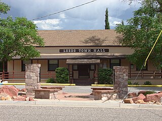
Leeds is a town in Washington County, Utah, United States. The population was 820 at the 2010 census.

<span class="mw-page-title-main">New Harmony, Utah</span> Town in the state of Utah, United States

New Harmony is a town in northern Washington County, Utah, United States. The population was 207 at the 2010 census.

<span class="mw-page-title-main">Huntsville, Utah</span> Town in the state of Utah, United States

Huntsville is a town in Weber County, Utah, United States. The population was 608 at the 2010 census. It is located in Ogden Valley. It is part of the Ogden–Clearfield, Utah Metropolitan Statistical Area, as well as the Ogden Valley census county division.

References

  1. "2019 U.S. Gazetteer Files". United States Census Bureau. Retrieved August 7, 2020.
  2. 1 2 U.S. Geological Survey Geographic Names Information System: Snowville
  3. 1 2 "Population and Housing Unit Estimates". United States Census Bureau. May 24, 2020. Retrieved May 27, 2020.
  4. 1 2 "U.S. Census website". United States Census Bureau . Retrieved 2008-01-31.
  5. "SNOWVILLE, UTAH (427931)". Western Regional Climate Center. Retrieved December 15, 2022.
  6. "Census of Population and Housing". Census.gov. Retrieved June 4, 2015.

Commons-logo.svg Media related to Snowville, Utah at Wikimedia Commons