Solvay, New York

Last updated

Solvay, New York
Onondaga County New York incorporated and unincorporated areas Solvay highlighted.svg
Location in Onondaga County and the state of New York.
Coordinates: 43°3′26″N76°12′53″W / 43.05722°N 76.21472°W / 43.05722; -76.21472
Country United States
State New York
County Onondaga
Founded1794
Government
  TypeVillage
  MayorDerek Baichi
Area
[1]
  Total1.62 sq mi (4.19 km2)
  Land1.62 sq mi (4.19 km2)
  Water0.00 sq mi (0.00 km2)
Elevation
499 ft (152 m)
Population
 (2020)
  Total6,645
  Density4,112.00/sq mi (1,587.49/km2)
Time zone UTC-5 (Eastern (EST))
  Summer (DST) UTC-4 (EDT)
ZIP code
13209
Area code 315
FIPS code 36-68286
GNIS feature ID0965631
Website villageofsolvay.com

Solvay is a village located in the town of Geddes, Onondaga County, New York, United States, and a suburb of the city of Syracuse. As of the 2020 census, the population was 6,645. The village is named after the Solvay brothers, Belgian inventors of the chemical process employed by the Solvay Process Company, formerly the major industry of the village.

Contents

History

The area was within the former Central New York Military Tract, but Solvay was in a location reserved for members of the Onondaga tribe.

The village was initially founded in 1794 by James Geddes and was initially called "Geddesburgh." The first residents were mostly Irish, subsequently joined by Tyroleans and Poles. Eventually the community became known for its population largely Italian in extraction. It still retains a large segment (about 35% in 2005) of population of Italian descent. More recently many families of Ukrainian descent have settled in the village.

The village was renamed "Solvay" after 1884, when the Solvay Process Company built a Solvay process plant to produce soda ash. The Village of Solvay was incorporated in 1895. Other major businesses of Solvay include the Frazer & Jones Company (Division of the Eastern Company), a foundry; Crucible Steel, producer of specialty steels; Iroquois China Company (Solvay China); Pass & Seymour, producing electrical wiring devices.

The Solvay Process plant, by then owned by Allied Chemical and Dye Corporation, closed in 1985. The community has remained stable despite this loss.

Upland Farm, the Frederick R. Hazard residence built in 1899; Joseph Lyman Silsbee, architect UplandFarm799.jpg
Upland Farm, the Frederick R. Hazard residence built in 1899; Joseph Lyman Silsbee, architect

Reflecting paternalistic programs of the Solvay Process Company and the Hazard family, the first village and school library was in Guild Hall. Then Solvay received a Carnegie library in 1902. James A. Randall of Syracuse was the architect (1902–05). The building was constructed with Hazard support.

Since the Hazards' time, the village has provided superior services, as envisioned by the family. Solvay has its own municipal electric company which provides service to the village at one of the least expensive rates in the nation. A typical three bedroom home in the village which is completely electric (meaning no natural gas service) sees an average bill of around $225 per month in the winter and $160 in the summer (2009).

The Solvay Public Library was listed on the National Register of Historic Places in 2007. [2]

Geography

Solvay is located at 43°3′26″N76°12′53″W / 43.05722°N 76.21472°W / 43.05722; -76.21472 (43.057316, -76.214649), [3] immediately west of Syracuse and south of the New York State Fairgrounds (far westside). Its eastern boundary is shared with Syracuse. The village is south of the east end of Onondaga Lake and is also south of Interstate 690. The Erie Canal passes through the village.

According to the United States Census Bureau, the village has a total area of 1.6 square miles (4.1 km2), all land.

Demographics

Historical population
CensusPop.Note
1890 563
1900 3,493520.4%
1910 5,13947.1%
1920 7,35243.1%
1930 7,9868.6%
1940 8,2012.7%
1950 7,868−4.1%
1960 8,73211.0%
1970 8,280−5.2%
1980 7,140−13.8%
1990 6,717−5.9%
2000 6,8451.9%
2010 6,584−3.8%
2020 6,6450.9%
U.S. Decennial Census [4]
Former Mayor Anthony Modafferi meets with former Congressman Jim Walsh Tony Modafferi and Jim Walsh.jpg
Former Mayor Anthony Modafferi meets with former Congressman Jim Walsh

As of the census [5] of 2000, there were 6,844 people, 3,030 households, and 1,766 families residing in the village. The population density was 4,164.6 inhabitants per square mile (1,608.0/km2). There were 3,291 housing units at an average density of 2,002.3 per square mile (773.1/km2). The racial makeup of the village was 95.81% White, 0.67% African American, 1.02% Native American, 0.39% Asian, 0.06% Pacific Islander, 0.29% from other races, and 1.75% from two or more races. Hispanic or Latino of any race were 2.37% of the population.

There were 3,030 households, out of which 26.8% had children under the age of 18 living with them, 39.4% were married couples living together, 14.4% had a female householder with no husband present, and 41.7% were non-families. 35.9% of all households were made up of individuals, and 16.1% had someone living alone who was 65 years of age or older. The average household size was 2.26 and the average family size was 2.94.

In the village, the population was spread out, with 23.3% under the age of 18, 8.5% from 18 to 24, 27.7% from 25 to 44, 20.6% from 45 to 64, and 20.0% who were 65 years of age or older. The median age was 38 years. For every 100 females, there were 85.9 males. For every 100 females age 18 and over, there were 82.5 males.

The median income for a household in the village was $34,084, and the median income for a family was $40,057. Males had a median income of $34,045 versus $23,822 for females. The per capita income for the village was $19,441. About 10.6% of families and 12.0% of the population were below the poverty line, including 20.2% of those under age 18 and 7.3% of those age 65 or over.

Related Research Articles

<span class="mw-page-title-main">Onondaga County, New York</span> County in New York, United States

Onondaga County is a county in the U.S. state of New York. As of the 2020 census, the population was 476,516. The county seat is Syracuse. The county is part of the Central New York region of the state.

<span class="mw-page-title-main">East Syracuse, New York</span> Village in New York, United States

East Syracuse is an incorporated village and a suburb of the City of Syracuse in eastern Onondaga County, New York, United States. As of the 2020 census, the population was 3,078. It is located immediately east of Syracuse, in the town of DeWitt.

<span class="mw-page-title-main">Fairmount, New York</span> Census-designated place in New York, United States

Fairmount is a hamlet in Onondaga County, New York, United States. Fairmount is a western suburb of Syracuse, located in the far southeastern corner of the town of Camillus. Its zip code is 13219 (Syracuse). It is located within the West Genesee Central School District. The population was 10,224 at the 2010 census.

<span class="mw-page-title-main">Galeville, New York</span> Census-designated place in New York, United States

Galeville is a hamlet in Onondaga County, New York, United States. The population was 4,617 at the 2010 census.

<span class="mw-page-title-main">Geddes, New York</span> Town in New York, United States

Geddes is a town in Onondaga County, New York, United States. As of the 2020 Census, the population was 17,088.

<span class="mw-page-title-main">Lakeland, New York</span> Census-designated place in New York, United States

Lakeland is a hamlet in Onondaga County, New York, United States. The population was 2,786 at the 2010 census. The community name is derived from its location next to Onondaga Lake.

<span class="mw-page-title-main">Liverpool, New York</span> Village in New York, United States

Liverpool is a lakeside village in Onondaga County, New York, United States. As of the 2020 census, the population was 2,242. The name was adopted from the city of Liverpool in the United Kingdom. The village is on Onondaga Lake, in the western part of the town of Salina and is northwest of Syracuse, of which it is a suburb.

<span class="mw-page-title-main">Lyncourt, New York</span> Census-designated place in New York, United States

Lyncourt is a hamlet in Onondaga County, New York, United States. The population was 4,250 at the 2010 census.

<span class="mw-page-title-main">Mattydale, New York</span> Census-designated place in New York, United States

Mattydale is a hamlet in Onondaga County, New York, United States. The population was 6,446 at the 2010 census.

<span class="mw-page-title-main">Minoa, New York</span> Village in New York, United States

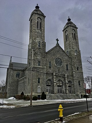
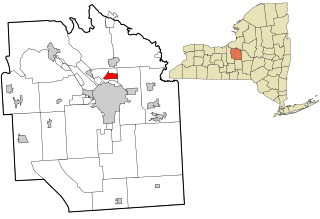
Minoa is a village in Onondaga County, New York, United States. As of the 2020 census, the population was 3,657. Minoa is in the northern part of the town of Manlius and is east of Syracuse.

<span class="mw-page-title-main">North Syracuse, New York</span> Village in New York, United States

North Syracuse is a village in Onondaga County, New York, United States. As of the 2020 census, the population was 6,739. North Syracuse is located in the towns of Cicero and Clay, north of the city of Syracuse.

<span class="mw-page-title-main">Onondaga, New York</span> Town in New York, United States

Onondaga is a town in Onondaga County, New York, United States, encompassing 65 square miles. As of the 2020 Census, the population was 22,937. The town is named after the native Onondaga tribe, part of the Iroquois Confederacy. Onondaga was incorporated April 2, 1798, and is located southwest of the city of Syracuse, which it borders. The villages and hamlets which make up the town are: Cedarvale, Howlett Hill, Navarino, Nedrow, Onondaga Hill, Sentinel Heights, South Onondaga, Southwood, Split Rock, and Taunton.

<span class="mw-page-title-main">Salina, New York</span> Town in New York, United States

Salina is a town in Onondaga County, New York, United States. As of the 2020 Census, the population was 33,223. The name of the town is derived from the Latin word for "salt." Salina is a northern suburb of Syracuse.

<span class="mw-page-title-main">Westvale, New York</span> Census-designated place in New York, United States

Westvale is a suburban community in Onondaga County, New York, United States. The population was 4,963 at the 2010 census.

<span class="mw-page-title-main">Camillus (village), New York</span> Village in New York, United States

Camillus is a village in Onondaga County, New York, United States. As of the 2020 census, the population was 1,222. The village takes its name from the town in which it is located. It is part of the Syracuse Metropolitan Statistical Area.

<span class="mw-page-title-main">Elbridge (village), New York</span> Village in New York, United States

Elbridge is a village. Located in the western part of the town of Elbridge in western Onondaga County, New York, United States, about 15 miles (24 km) west of Syracuse. It is part of the Syracuse Metropolitan Statistical Area. As of the 2020 census, the population was 921.

<span class="mw-page-title-main">Manlius (village), New York</span> Village in New York, United States

Manlius is a village in Onondaga County, New York, United States, and a southeast suburb of Syracuse. As of the 2020 census, the population was 4,662.

<span class="mw-page-title-main">Marcellus (village), New York</span> Village in New York, United States

Marcellus is a village in the town of Marcellus in Onondaga County, New York, United States. As of the 2020 census, the population was 1,745. The village is southwest of Syracuse and is in the southern part of the town of Marcellus.

<span class="mw-page-title-main">Marcellus, New York</span> Town in New York, United States

Marcellus is a town in Onondaga County, New York, United States. As of the 2020 Census, the population was 6,066. The town was probably named after Marcus Claudius Marcellus, a Roman general, by a clerk interested in the Classics.

<span class="mw-page-title-main">Syracuse metropolitan area</span> Metropolitan Statistical Area in New York, United States

The Syracuse Metropolitan Statistical Area, as defined by the United States Census Bureau, is an area consisting of three counties in central New York, anchored by the city of Syracuse. As of the 2020 census, the MSA had a population of 662,057, slightly down from 662,577 in the 2010 census.

References

  1. "ArcGIS REST Services Directory". United States Census Bureau. Retrieved September 20, 2022.
  2. "National Register Information System". National Register of Historic Places . National Park Service. March 13, 2009.
  3. "US Gazetteer files: 2010, 2000, and 1990". United States Census Bureau. February 12, 2011. Retrieved April 23, 2011.
  4. "Census of Population and Housing". Census.gov. Retrieved June 4, 2015.
  5. "U.S. Census website". United States Census Bureau . Retrieved January 31, 2008.