South Central Siberia

Last updated

South Central Siberia is a geographical region north of the point where Russia, China, Kazakhstan and Mongolia come together.

Contents

Kemerovo Oblast highlighted
Kuznetsk Basin to the west and Minusinsk basin to the east.
Altai Republic to the south, Altai Krai northwest of that and Tuva to the southeast Map of Russia - Kemerovo Oblast (2008-03).svg
Kemerovo Oblast highlighted
Kuznetsk Basin to the west and Minusinsk basin to the east.
Altai Republic to the south, Altai Krai northwest of that and Tuva to the southeast

The Four Corners

Topographic map of Central Asia. The area in question is between the Altai region and Novosibirsk. Zentralasien topo.png
Topographic map of Central Asia. The area in question is between the Altai region and Novosibirsk.
The Altai Mountains and surrounding areas Altai, Tienschan-Orte.png
The Altai Mountains and surrounding areas

At approximately 49°8′8″N87°33′46″E / 49.13556°N 87.56278°E / 49.13556; 87.56278 , the borders of Russia, China, Mongolia and Kazakhstan intersect in the Altai Mountains. Mongolia and Kazakhstan are separated by a 55km stretch of the Sino-Russian border between the Altai Republic, a federal subject of Russia, and Altay Prefecture in the Xinjiang Uyghur Autonomous Region of China. To the east, Tavan Bogd Uul in Bayan-Ölgii Province, Mongolia, marks the end of the Sino-Russian border. To the west, is Kazakhstan's East Kazakhstan Province.

The Altai mountains on the Russian side of the border have been designated a UNESCO World Heritage Site. [1]

South: Altai Republic

Above the "Four Corners" and in the southern part of South Central Siberia is the Altai Republic (not to be confused with the Altai Krai to the northwest). It contains the central knot to the Altai Mountains. The area is very mountainous and has few good roads. It was inhabited by various Turkic groups who gradually became the Altay people. As the surrounding steppes filled with Russians, many of the lowland Turks were Russified or retreated to the mountains. The area only came under definitive Russian control in the 1860s. The M52 highway (Russia) runs northwest from here.

Northern mountain range: Abakans and Kuznetsk Alatau

Northern South Central Siberia includes the Altai Republic, which is a 400 km projection of forested mountains which bends slightly to the west at the tip. It is called the Abakan Range in the south and Kuznetsk Alatau in the north. North of its northern end is the town of Tomsk.

West: Kuznetsk Depression

The west part of South Central Siberia includes the steppe of the Kuznetsk Depression, which contains the large Kuznetsk Basin coal fields, the mountains of the Abakans and Kuznetsk Alatau and the Salair Ridge which ends near Novosibirsk.

In the Soviet era, the Kuznetsk Basin coal fields were the largest Russian coal field after the Donets Basin. The name Kuznets means blacksmith and comes from the 'Blacksmith Tatars' or Shors, who were notable metal workers.

The Russians reached the area as early as 1618. The Abakans, Kuznetsk Alatau and the Kuznetsk Basin form the Kemerovo Oblast with its mostly Russian population. The Tom River drains the basin and joins the Ob River north of Tomsk. The town of Novokuznetsk was founded in 1618.

East: Minusinsk Depression

The eastern part of South Central Siberia, between the Kuznetsk Alatau and the Sayan Mountains, includes the steppe of the Minusinsk Depression which is the core of Khakassia. The Yenisei River flows north through its center. The Abakan River flows from the base of the depression north and slightly east to the Yenisei at Abakan town, near where another river comes in from the east. Minusinsk town is a few kilometres east of Abakan. The Chulym River (Ob River) starts in the northwest corner of the depression, arcs into the Taiga north of the Alatau and joins the Ob River. East of the river is the southern tip of Krasnoyarsk Krai.

This area was a center of the Afanasevo culture, a suggested homeland for the Tocharians. Later it was the home of the Yenisei Kirghiz, who gave their name to the Kirgiz further south. The Khakas of Khakassia may be their descendants.

Southeast: Tuva

East of the Altai and southeast of Minusinsk is Tuva. Tuva is bordered on the south by the Tannu-Ola Mountains, which separate it from the Mongolian Great Lakes Depression, on the west by the Altai, on the northwest by the Western Sayans which separate it from the Minusinsk Depression, on the north by the Eastern Sayans and on the east by mountains on the Mongolian border.

The core area is the Tuva Depression, where Kyzyl is located, the capital city of the Tuva Republic. The Yenisei River flows west here and then breaks through the Western Sayans in a long narrow gorge which contains the Sayano-Shushenskaya Dam north of the Tuva border.

Tuva was traditionally part of Mongolia, and only passed to the Soviet Union—Russia in the 20th century.

Surrounding area

To the north, South Central Siberia merges into the Siberian forests.

To the south, South Central Siberia merges into the mountains along the former Sino-Soviet border. Dzungaria is directly to the south.

To the west of South Central Siberia is the agricultural steppe of the Altai Krai with its Russian population. Here the Katun River and the Biya River join to form the Ob River. Further west, between the Ob and Irtysh Rivers are the Baraba steppe in the north and the Kalunda Steppe in the south.

To the east, the Western and then Eastern Sayan Mountains extend east to the southern tip of Lake Baikal.

Other information

See also

Related Research Articles

<span class="mw-page-title-main">Ob (river)</span> Major river in Siberia

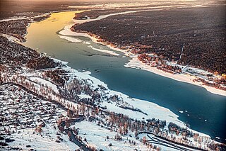
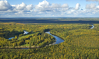
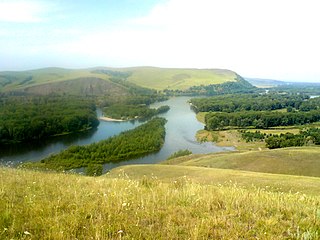
The Ob is a major river in Russia. It is in western Siberia; and together with Irtysh forms the world's seventh-longest river system, at 5,410 kilometres (3,360 mi). It forms at the confluence of the Biya and Katun which have their origins in the Altai Mountains. It is the westernmost of the three great Siberian rivers that flow into the Arctic Ocean. Its flow is north-westward, then northward.

<span class="mw-page-title-main">Altai Mountains</span> Mountain range in Central–East Asia

<span class="mw-page-title-main">Sayan Mountains</span> Mountain range in southern Siberia, Russia and northern Mongolia

The Sayan Mountains are a mountain range in southern Siberia, Russia and northern Mongolia. In the past, it served as the border between Mongolia and Russia.

<span class="mw-page-title-main">Khakassia</span> First-level administrative division of Russia

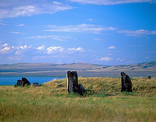
Khakassia, officially the Republic of Khakassia, is a republic of Russia located in southern Siberia. It is situated between Krasnoyarsk Krai to the north and the Altai Republic to the south.

<span class="mw-page-title-main">West Siberian Plain</span> Large plain that occupies the western portion of Siberia

The West Siberian Plain is a large plain that occupies the western portion of Siberia, between the Ural Mountains in the west and the Yenisei River in the east ,and the Altai Mountains on the southeast. Much of the plain is poorly drained and consists of some of the world's largest swamps and floodplains. Important cities include Chelyabinsk, Novosibirsk, Omsk, and Tomsk, as well as Surgut and Nizhnevartovsk.

<span class="mw-page-title-main">Central Siberian Plateau</span> Plateau in North Asia

The Central Siberian Plateau is a vast mountainous area in Siberia, one of the Great Russian Regions.

<span class="mw-page-title-main">Tannu-Ola mountains</span> Central Asian mountain range

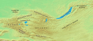
The Tannu-Ola mountains is a mountain range in southern Siberia, in the Tuva Republic of Russia. It extends in an east–west direction and curves along the Mongolian border. Its highest peak reaches 3,061 m (10,043 ft). The Tannu-ola mountains are mentioned in the 13th-century text The Secret History of the Mongols under the name "Tanglu mountains" (唐麓), and also in the JāmiʿAl-tawārīkh of Rashid-al-Din Hamadani (1247–1318) under the name "Toungat mountains" (تنغات). By the Qing dynasty the name has been changed to Tangnu (唐努) mountains, from which the modern name is derived. All names are probably rooted in the old Turkic word taŋ - "wonder, awe, wondrous."

Siberian natural resources refers to resources found in Russian Siberia, in the North Asian Mainland. The Siberian region is rich in resources, including coal, oil and metal ores.

<span class="mw-page-title-main">Minusinsk Hollow</span> Geographic region of Siberia

Minusinsk Basin or Khakass-Minusinsk Basin is in Khakassia and Krasnoyarsk Krai, Russia located among mountains of South Siberia.

<span class="mw-page-title-main">Kuznetsk Alatau</span> Mountain range in Siberia

Kuznetsk Alatau is a mountain range in southern Siberia, Russia. The range rises in the Altai-Sayan region of the South Siberian Mountains, northwest of Mongolia. The Siberian Railway skirts the northern limit of the range.

<span class="mw-page-title-main">Abakan Range</span> Mountain range in Siberia, Russia

Abakan Range is a mountain range in Southwestern Siberia, located mainly in Khakassia, Russia: It is mostly covered by taiga, up to 1,500 m (4,900 ft), followed by mountainous tundra. The range also consists sparse areas of granite, gabbro, and diorite.

Kuznetsk Depression is located among mountains of South-Central Siberia, including: Kuznetsk Alatau to the Northeast, Salair Ridge to the Southwest, and Mountainous Shoria to the South. It is within Kemerovo Oblast.

<span class="mw-page-title-main">Uvs Lake Basin</span> Endorheic basin in Tuva, Russia and Mongolia

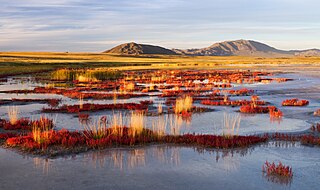
Uvs Lake Basin is an endorheic basin located on the territorial border of Mongolia and Tuva, a republic of the Russian Federation. The basin is part of the Central Asian Internal Drainage Basin and is named after Uvs Lake, a large saline lake situated in the western part of its drainage basin, and is one of the last remnants of the mammoth steppes. Uvs Lake is a shallow lake with an area of 3,350 km2 (1,290 sq mi). Its entire basin, which includes several smaller lakes, is 70,000 km2 (27,000 sq mi).

The Altai-Sayan region is an area of Inner Asia proximate to the Altai Mountains and the Sayan Mountains, near to where Russia, China, Mongolia and Kazakhstan come together. This region is one of the world centers of temperate plant diversity. Its biological, landscape, historical, cultural and religious diversity is unique. 3,726 species of vascular plants are registered in the region including 700 threatened or rare species, 317 of which are endemic; fauna consists of 680 species, 6% of which are endemic. Its ecosystem is comparatively unchanged since the last ice age, and it is the host of endangered species that include the saiga, nerpa, and snow leopard. It is the focus of ongoing international and regional environmental conservation initiatives.

<span class="mw-page-title-main">Tomsk Governorate</span> Governorate of the Russian Empire

Tomsk Governorate was an administrative division of the Russian Empire, Russian Republic, Russian Soviet Federative Socialist Republic located in Siberia from 1804 to 1925 as part of the Siberian Governorate-General (1804–1822) and the West Siberian Governorate-General (1822–1882). Its seat was in the city of Tomsk.

<span class="mw-page-title-main">Khakassia Nature Reserve</span> Nature reserve in Khakassia, Russia

Khakasski Nature Reserve is a Russian 'zapovednik' covering two large mountain areas, and a cluster of seven steppe sites located within the left bank of the Minusinsk depression. The reserve is situated in the Tashtypsky District of Khakassia. It was originally created to preserve steppe ecosystems, wetlands and waterfowl nesting sites, and a historical complex of monuments and cemeteries from the 4-11 centuries BC. The reserve is particularly noted for its variety of large lakes on the Yenisei River migration route for birds. The current configuration of protected sectors was established in 1999, and covers a total area of 267,483 ha (1,032.76 sq mi).

<span class="mw-page-title-main">Kuznetsk Alatau Nature Reserve</span> Nature reserve in Kemerovo Oblast, Russia

Kuznetsk Alatau Nature Reserve is a Russian 'zapovednik' on the Kuznetsk Alatau, a mountain ridge in the Altai-Sayan mountain region in southwestern Siberia. The Kuznetsk Alatau consists of several ranges of medium height, between which there are river valleys. The reserve is in the watershed of the Tom River and the Chuly River. It is spread over three districts of Kemerovo Oblast: Tisulsky District, Mezhdurechensky District, and Novokuznetsky District. The reserve was established in 1989 and covers an area of 412,900 ha (1,594 sq mi).

<span class="mw-page-title-main">Sayan montane conifer forests</span> Coniferous forests in Russia and Mongolia

The Sayan montane conifer forests ecoregion covers the mid-elevation levels of the Sayan Mountains, the high mountain range between the taiga of Siberia, Russia to the north, and the steppes of Mongolia to the south. The slopes of the mountains at the mid-altitudes are covered by Temperate coniferous forest. The ecoregion is in the Palearctic realm, with a cold semi-arid climate. It covers 35,741,835 km2 (13,800,000 sq mi).

<span class="mw-page-title-main">South Siberian Mountains</span> Series of mountain ranges in Russia and Mongolia

The South Siberian Mountains are one of the largest mountain systems of the Russian Federation. The total area of the system of mountain ranges is more than 1.5 million km². The South Siberian Mountains are located in the Siberian and Far Eastern Federal Districts of Russia, as well as partly in Mongolia. The territory of the mountain system is one of the Great Russian Regions.

<span class="mw-page-title-main">Chebaki Fortress</span>

Content in this edit is translated from the existing Russian Wikipedia article at ru:Чебаки (крепость); see its history for attribution

References

  1. UNESCO World Heritage Centre. "Golden Mountains of Altai - UNESCO World Heritage Centre". Whc.unesco.org. Retrieved 2019-11-08.

Further reading