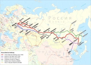
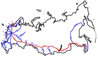
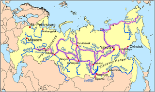
The Trans-Siberian Railway,[lower-alpha 1] historically known as the Great Siberian Route[lower-alpha 2] and often shortened to Transsib,[lower-alpha 3] is a large railway system that connects European Russia to the Russian Far East.[1] Spanning a length of over 9,289 kilometers (5,772 miles), it is the longest railway line in the world.[2] It runs from the city of Moscow in the west to the city of Vladivostok in the east.
During the period of the Russian Empire, government ministers—personally appointed by Alexander III and his son Nicholas II—supervised the building of the railway network between 1891 and 1916. Even before its completion, the line attracted travelers who documented their experiences.[3] Since 1916, the Trans-Siberian Railway has directly connected Moscow with Vladivostok. As of 2021[update], expansion projects remain underway, with connections being built to Russia's neighbors (namely Mongolia, China, and North Korea).[4][5] Additionally, there have been proposals and talks to expand the network to Tokyo, Japan, with new bridges or tunnels that would connect the mainland railway through the Russian island of Sakhalin and the Japanese island of Hokkaido.[4]
The railway is often associated with the main transcontinental Russian line that connects many large and small cities of the European and Asian parts of Russia. At a Moscow–Vladivostok track length of 9,289 kilometers (5,772 miles),[6] it spans a record eight time zones.[7] Taking eight days to complete the journey, it was the third-longest single continuous service in the world,[when?] after the Moscow–Pyongyang service 10,267 kilometers (6,380mi)[8] and the formerKyiv (Kiev)–Vladivostok service 11,085 kilometers (6,888mi),[9] both of which also follow the Trans-Siberian for much of their routes.[10]
The third primary route is the Trans-Mongolian Railway, which coincides with the Trans-Siberian as far as Ulan-Ude on Lake Baikal's eastern shore. From Ulan-Ude the Trans-Mongolian heads south to Ulaanbaatar before making its way southeast to Beijing. In 1991, a fourth route running further to the north was finally completed, after more than five decades of sporadic work. Known as the Baikal–Amur Mainline (BAM), this recent extension departs from the Trans-Siberian line at Taishet several hundred miles west of Lake Baikal and passes the lake at its northernmost extremity. It crosses the Amur River at Komsomolsk-na-Amure (north of Khabarovsk), and reaches the Tatar Strait at Sovetskaya Gavan.[10]
History
Demand and design
In the late 19th century, the development of Siberia was hampered by poor transport links within the region and with the rest of the country. Aside from the Great Siberian Route, roads suitable for wheeled transport were rare. For about five months of the year, rivers were the main means of transport. During winter, cargo and passengers traveled by horse-drawn sledges over the winter roads, many of which were the same rivers but frozen.[11]
The first steamboat on the River Ob, Nikita Myasnikov's Osnova, was launched in 1844. However early innovation had proven to be difficult, and it was not until 1857 that steamboat shipping had begun major development on the Ob system. Steamboats began operation on the Yenisei in 1863, and on the Lena and Amur in the 1870s. While the comparative flatness of Western Siberia was served by good river systems, the major river systems Ob–Irtysh–Tobol–Chulym of Eastern Siberia had difficulties. The Yenisei, the upper course of the Angara River below Bratsk which was not easily navigable because of the rapids, and the Lena, were mostly navigable only in the north–south direction, making west–east transportation difficult. An attempt to partially remedy the situation by building the Ob–Yenisei Canal had not yielded great success. These issues in the region created the need for a railway to be constructed.[10]
The first railway projects in Siberia emerged after the completion of the Saint Petersburg–Moscow Railway in 1851.[12] One of the first was the Irkutsk–Chita project, proposed by the American entrepreneur Perry Collins and supported by Transport Minister Constantine Possiet with a view toward connecting Moscow to the Amur River, and consequently the Pacific Ocean. Siberia's governor, Nikolay Muravyov-Amursky, was anxious to advance Russian colonization of the now Russian Far East, but his plans were unfeasible due to colonists importing grain and food from China and Korea.[13] It was on Muravyov's initiative that surveys for a railway in the Khabarovsk region were conducted.
Before 1880, the central government had virtually ignored these projects, due to weaknesses in Siberian enterprises, an inefficient bureaucracy, and financial risk. By 1880, there was a large number of rejected and upcoming applications for permission to construct railways in order to connect Siberia with the Pacific, but not Eastern Russia. This worried the government and made connecting Siberia with Central Russia a pressing concern. The design process lasted 10 years. Along with the actual route constructed, alternative projects were proposed:
The line was divided into seven sections, most or all of which was simultaneously worked on by 62,000 workers. With financial support provided by leading European financier, Baron Henri Hottinguer of the Parisian bankers Hottinger & Cie, the total cost estimated at £35 million was raised with the first section (Chelyabinsk to the River Ob) and finished at a cost of £900,000 lower than anticipated.[14] Railwaymen argued against suggestions to save funds, such as installing ferryboats instead of bridges over the rivers until traffic increased.
Unlike the rejected private projects that intended to connect the existing cities that required transport, the Trans-Siberian did not have such a priority. Thus, to save money and avoid clashes with land owners, it was decided to lay the railway outside the existing cities. However, due to the swampy banks of the Ob River near Tomsk, (The largest settlement at the time), the idea to construct a bridge was rejected.
The railway was laid 70km (43mi) to the south (instead crossing the Ob at Novonikolaevsk, later renamed Novosibirsk); a dead-end branch line connected with Tomsk, depriving the city of the prospective transit railway traffic and trade.[10]
Construction
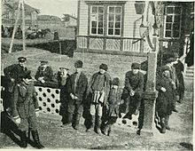
Clearing on the right-of-way of the Eastern Siberian Railway, 1895Construction work being performed by convicts on the Eastern Siberian Railway near Khabarovsk, 1895
On 9 March 1891, the Russian government issued an imperial rescript in which it announced its intention to construct a railway across Siberia.[15] Tsarevich Nicholas (later Tsar Nicholas II) inaugurated the construction of the railway in Vladivostok on 19 May that year.[16]
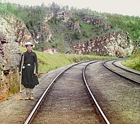
Lake Baikal is more than 640 kilometers (400 miles) long and more than 1,600 meters (5,200 feet) deep. Until the Circum-Baikal Railway was built the line ended on either side of the lake. The ice-breakingtrain ferrySSBaikal built in 1897 and smaller ferry SS Angara built in about 1900 made the four-hour crossing to link the two railheads.[17][18]
The Russian admiral and explorer Stepan Makarov (1849–1904) designed Baikal and Angara but they were built in Newcastle upon Tyne, by Armstrong Whitworth. They were "knock down" vessels; that is, each ship was bolted together in the United Kingdom, every part of the ship was marked with a number, the ship was disassembled into many hundreds of parts and transported in kit form to Listvyanka where a shipyard was built especially to reassemble them.[18] Their boilers, engines and some other components were built in Saint Petersburg[18] and transported to Listvyanka to be installed. Baikal had 15 boilers, four funnels, and was 64 meters (210ft) long. it could carry 24 railway coaches and one locomotive on the middle deck. Angara was smaller, with two funnels.[17][18]
Completion of the Circum-Baikal Railway in 1904 bypassed the ferries, but from time to time the Circum-Baikal Railway suffered from derailments or rockfalls so both ships were held in reserve until 1916. Baikal was burnt out and destroyed in the Russian Civil War[17][18] but Angara survives. It has been restored and is permanently moored at Irkutsk where it serves as an office and a museum.[17]
In winter, sleighs were used to move passengers and cargo from one side of the lake to the other until the completion of the Lake Baikal spur along the southern edge of the lake. With the Amur River Line north of the Chinese border being completed in 1916, there was a continuous railway from Petrograd to Vladivostok that, to this day, is the world's second longest railway line. Electrification of the line, begun in 1929 and completed in 2002, allowed a doubling of train weights to 6,000 metric tons (5,900 long tons; 6,600 short tons). There were expectations upon electrification that it would increase rail traffic on the line by 40 percent.[19]
The entire length of the Trans-Siberian Railway was double track by 1939.[20]
Effects
Siberian peasants watching a train at a station, 1902
Siberian agriculture began to send cheap grain westwards beginning around 1869.[citation needed] Agriculture in Central Russia was still under economic pressure after the end of serfdom, which was formally abolished in 1861. To defend the central territory and prevent possible social destabilization, the Tsarist government introduced the Chelyabinsktariff-break (Челябинский тарифный перелом) in 1896, a tariff barrier for grain passing through Chelyabinsk, and a similar barrier in Manchuria. This measure changed the nature of export: mills emerged to produce bread from grain in Altai Krai, Novosibirsk and Tomsk, and many farms switched to corn (maize) production.
The railway immediately filled to capacity with local traffic, mostly wheat. From 1896 until 1913 Siberia exported on average 501,932 metric tons (494,005 long tons; 553,285 short tons) (30,643,000 pood) of grain and flour annually.[21] During the Russo-Japanese War of 1904–1905, military traffic to the east disrupted the flow of civil freight.
The Trans-Siberian Railway brought with it millions of peasant-migrants from the Western regions of Russia and Ukraine.[22] Between 1906 and 1914, the peak migration years, about 4 million peasants arrived in Siberia.[23]
Historian Christian Wolmar argues that the railroad was a failure, because it was built for narrow political reasons, with poor supervision and planning. The costs were vastly exaggerated to enrich greedy bureaucrats. The planners hoped it would stimulate settlement, but the Siberian lands were too infertile and cold and distant. There was little settlement beyond 30 miles from the line. The fragile system could not handle the heavy traffic demanded in wartime, so the Japanese in 1904 knew they were safe in their war with Russia. Wolmar concludes:
The railway, which was single track throughout, with the occasional passing loop, had, unsurprisingly, been built to a deficient standard in virtually every way. The permanent way was flimsy, with lightweight rails that broke easily, insufficient ballast, and railroad ties often carved from green wood that rotted in the first year of use. The small bridges were made of soft pine and rotted easily. The embankments were too shallow and narrow, often just 10 ft wide instead of the 16 ft prescribed in the design, and easily washed away. There were vicious gradients and narrow curves that wore out the fringe flanges on the wheels of the rolling stock after as little as six weeks use.[24]
War and revolution
Trans-Siberian Railway, c. 1904
In the Russo-Japanese War (1904–1905), the strategic importance and limitations of the Trans-Siberian Railway contributed to Russia's defeat in the war. As the line was single track, transit was slower as trains had to wait in crossing sidings for opposing trains to cross. This limited the capacity of the line and increased transit times. A troop train or a train carrying injured personnel traveling from east to west would delay the arrival of troops or supplies and ammunition in a train traveling from west to east. The supply difficulties meant the Russian forces had limited troops and supplies while Japanese forces with shorter lines of communication were able to attack and advance.
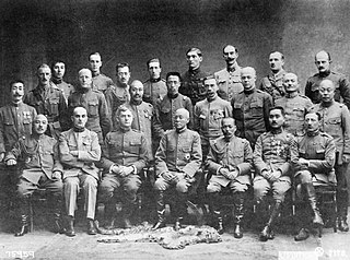
After the Russian Revolution of 1917, the railway served as the vital line of communication for the Czechoslovak Legion and the allied armies that landed troops at Vladivostok during the Siberian Intervention of the Russian Civil War. These forces supported the White Russian government of Admiral Alexander Kolchak, based in Omsk, and White Russian soldiers fighting the Bolsheviks on the Ural front. The intervention was weakened, and ultimately defeated, by partisan fighters who blew up bridges and sections of track, particularly in the volatile region between Krasnoyarsk and Chita.[25]
There was traveling the leader of legions politician Milan Rastislav Stefanik[26] from Moscow to Vladivostok in March and August 1918, on his journey to Japan and United States of America.[27] The Trans-Siberian Railway also played a very direct role during parts of Russia's history, with the Czechoslovak Legion using heavily armed and armored trains to control large amounts of the railway (and of Russia itself) during the Russian Civil War at the end of World War I.[28] As one of the few fighting forces left in the aftermath of the imperial collapse, and before the Red Army took control, the Czechs and Slovaks were able to use their organization and the resources of the railway to establish a temporary zone of control before eventually continuing onwards towards Vladivostok, from where they emigrated back to Czechoslovakia.
During World War II, the Trans-Siberian Railway played an important role in the supply of the powers fighting in Europe. In 1939–1941 it was a source of rubber for Germany thanks to the USSR-Germany pact. While Germany's merchant shipping was shut down, the Trans-Siberian Railway (along with its Trans-Manchurian branch) served as the essential link between Germany and Japan, especially for rubber. By March 1941, 300 metric tons (300 long tons; 330 short tons) of this material would, on average, traverse the Trans-Siberian Railway every day on its way to Germany.[29]
At the same time, a number of Jews and anti-Nazis used the Trans-Siberian Railway to escape Europe, including the mathematician Kurt Gödel and Betty Ehrlich Löwenstein, mother of British actor, director and producer Heinz Bernard.[30] Several thousand Jewish refugees were able to make this trip thanks to the Curaçao visas issued by the Dutch consul Jan Zwartendijk[31] and the Japanese visas issued by the Japanese consul, Chiune Sugihara, in Kaunas, Lithuania. Typically, they took the TSR to Vladivostok, then by ship to US. Until June 1941, pro-Nazi ethnic Germans from the Americas used the TSR to go to Germany.[32]
The situation reversed after 22 June 1941. By invading the Soviet Union, Germany cut off its only reliable trade route to Japan. Instead, it had to use fast merchant ships and later large oceanic submarines to evade the Allied blockade. On the other hand, the USSR received Lend-Lease supplies from the US. Even after Japan went to war with the US, despite German complaints, Japan usually allowed Soviet ships to sail between the US and Vladivostok unmolested.[33] As a result, the Pacific Route – via northern Pacific Ocean and the TSR – became the safest connection between the US and the USSR.[citation needed]
Accordingly, it accounted for as much freight as the North Atlantic–Arctic and Iranian routes combined, though cargoes were limited to raw materials and non-military goods. From 1941 to 1942 the TSR also played an important role in relocating Soviet industries from European Russia to Siberia in the face of the German invasion. The TSR also transported Soviet troops west from the Far East to take part in the Soviet counter-offensive in December 1941.
In 1944–45 the TSR was used to prepare for the Soviet–Japanese War of August 1945; see Pacific Route. When an Anglo-American delegation visited Moscow in October 1944 to discuss the Soviet Union joining the war against Japan, Alanbrooke was told by General Antonov and Stalin himself that the line capacity was 36 pairs of trains per day, but only 26 could be counted on for military traffic; see Pacific Route. The capacity of each train was from 600 to 700 tons.[34]
Although the Japanese estimated that an attack was not likely before Spring 1946, Stavka had planned for a mid-August 1945 offensive, and had concealed the buildup of a force of 90 divisions; many had crossed Siberia in their vehicles to avoid straining the rail link.[35]
A trainload of containers can be taken from Beijing to Hamburg, via the Trans-Mongolian and Trans-Siberian lines in as little as 15 days, but typical cargo transit times are usually significantly longer[36] and typical cargo transit time from Japan to major destinations in European Russia was reported as around 25 days.[37]
According to a 2009 report, the best travel times for cargo block trains from Russia's Pacific ports to the western border (of Russia, or perhaps of Belarus) were around 12 days, with trains making around 900km (559mi) per day, at a maximum operating speed of 80km/h (50mph). In early 2009; however, Russian Railways announced an ambitious "Trans-Siberian in Seven Days" plan. According to this plan, $11 billion will be invested over the next five years to make it possible for goods traffic to cover the same 9,000km (5,592mi) distance in just seven days. The plan will involve increasing the cargo trains' speed to 90km/h (56mph) in 2010–2012, and, at least on some sections, to 100km/h (62mph) by 2015. At these speeds, goods trains will be able to cover 1,500km (932mi) per day.[38]
On January 11, 2008, China, Mongolia, Russia, Belarus, Poland, and Germany agreed to collaborate on a cargo train service between Beijing and Hamburg.[39]
The railway can typically deliver containers in 1⁄3 to 1⁄2 of the time of a sea voyage, and in late 2009 announced a 20% reduction in its container shipping rates.[citation needed] With its 2009 rate schedule, the Trans-Siberian Railway will transport a forty-foot container to Poland from Yokohama for $2,820, or from Busan for $2,154.[40]
Trans-Siberian route in seven days
In 2008, the Russian Railways JSC (state company) launched a program for the accelerated delivery of containers cargo by block trains from the Far-Eastern ports (Vladivostok, Nakhodka and others) to the western borders of Russia, called "Transsib in 7 days". Within the framework of the program it is planned to decrease the cargo delivery time from the Far East from 11 days in 2008 to seven days in 2015.[needs update] The length of the routes is about 10,000km (6,200mi). The speed of delivery via the block trains should increase from 900km (560mi) per day in 2008 to 1,500km (930mi) per day in 2015. The first accelerated experimental block-train was launched in February 2009 from Vladivostok to Moscow. The length of the route was about 9,300km (5,800mi), the actual time of the experimental train's delivery was 7 days and 5 hours, and the average route speed was up to 1,289km (801mi) per day. The maximum route speed of the train was 1,422km (884mi) per day.
View from the rear platform of the Simskaia railway station of the Samara–Zlatoust Railway, c. 1910
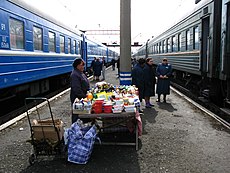
Almost every station on Trans-Siberian Railway has food sellers, often local vendors who sell local food such as fish (like Baikal omul), pirozhki, and potatoes. Besides food stands, there are also small kiosks
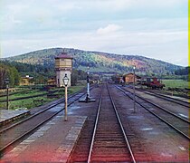
Snow in late April at Nazyvayevsk station, Siberia
The train ferry SSBaikal in service on Lake Baikal
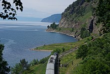
Train entering a Circum-Baikal tunnel west of Kultuk
Vladivostok terminus of the Trans-Siberian Railway
The marker for kilometer 9,288 (mile 5,771.3) at the end of the Trans-Siberian Railway at Vladivostok railway station
Some trains would leave Moscow from Kazansky Rail Terminal instead of Yaroslavsky Rail Terminal; this would save some 20km (12mi) off the distances, because it provides a shorter exit from Moscow onto the Nizhny Novgorod main line.
One can take a night train from Moscow's Kursky Rail Terminal to Nizhny Novgorod, make a stopover in the Nizhny and then transfer to a Siberia-bound train
From 1956 to 2001 many trains went between Moscow and Kirov via Yaroslavl instead of Nizhny Novgorod. This would add some 29km (18mi) to the distances from Moscow, making the total distance to Vladivostok at 9,288km (5,771mi).
Other trains get from Moscow (Kazansky Terminal) to Yekaterinburg via Kazan.
Between Yekaterinburg and Omsk it is possible to travel via Kurgan Petropavlovsk (in Kazakhstan) instead of Tyumen.
One can bypass Yekaterinburg altogether by traveling via Samara, Ufa, Chelyabinsk and Petropavlovsk; this was historically the earliest configuration.
Depending on the route taken, the distances from Moscow to the same station in Siberia may differ by several tens of km (a few dozen miles).
The Trans–Manchurian line, as e.g. used by train No.020, Moscow–Beijing[41] follows the same route as the Trans-Siberian between Moscow and Chita and then follows this route to China:
Branch off from the Trans-Siberian-line at Tarskaya (6,274km (3,898mi) from Moscow)
Changchun (7,820km (4,859mi) from Moscow) Chinese city
Beijing (8,961km (5,568mi) from Moscow) the Chinese capital
The express train (No. 020) travel time from Moscow to Beijing is just over six days. There is no direct passenger service along the entire original Trans-Manchurian route (i.e., from Moscow or anywhere in Russia, west of Manchuria, to Vladivostok via Harbin), due to the obvious administrative and technical (gauge break) inconveniences of crossing the border twice. Assuming sufficient patience and possession of appropriate visas, however, it is still possible to travel all the way along the original route, with a few stopovers (e.g. in Harbin, Grodekovo and Ussuriysk).[citation needed]
Such an itinerary would pass through the following points from Harbin east:
The highest point of Trans–Siberian Railroad is at Yablonovy pass at an altitude of 1070m situated in the Yablonoi Mountains, in Transbaikal (mainly in Zabaykalsky Krai), Siberia, Russia. The Trans–Siberian Railroad passes the mountains at Chita and runs parallel to the range before going through a tunnel to bypass the heights.[42]
The Baikal–Amur Mainline is a 1,520 mm broad-gauge railway line in Russia. Traversing Eastern Siberia and the Russian Far East, the 4,324 km (2,687 mi)-long BAM runs about 610 to 770 km north of and parallel to the Trans-Siberian Railway.
Ulan-Ude is the capital city of Buryatia, Russia, located about 100 kilometers (62 mi) southeast of Lake Baikal on the Uda River at its confluence with the Selenga. According to the 2021 Census, 437,565 people lived in Ulan-Ude; up from 404,426 recorded in the 2010 Census, making the city the third-largest in the Russian Far East by population.
The Russian Far East is a region in Northeast Asia. It is the easternmost part of Russia and the Asian continent; and is administered as a part of the Far Eastern Federal District, which is located between Lake Baikal in eastern Siberia and the Pacific Ocean. The area's largest city is Khabarovsk, followed by Vladivostok. The region shares land borders with the countries of Mongolia, China, and North Korea to its south, as well as maritime boundaries with Japan to its southeast, and with the United States along the Bering Strait to its northeast.
The early history of Siberia was greatly influenced by the sophisticated nomadic civilizations of the Scythians (Pazyryk) on the west of the Ural Mountains and Xiongnu (Noin-Ula) on the east of the Urals, both flourishing before the common era. The steppes of Siberia were occupied by a succession of nomadic peoples, including the Khitan people, various Turkic peoples, and the Mongol Empire. In the Late Middle Ages, Tibetan Buddhism spread into the areas south of Lake Baikal.
The Far Eastern Republic, sometimes called the Chita Republic, was a nominally independent state that existed from April 1920 to November 1922 in the easternmost part of the Russian Far East. Although nominally independent, it largely came under the control of the Russian Soviet Federative Socialist Republic (RSFSR), which envisaged it as a buffer state between the RSFSR and the territories occupied by Japan during the Russian Civil War of 1917–1922. Its first president was Alexander Krasnoshchyokov.
The Chinese Eastern Railway or CER, is the historical name for a railway system in Northeast China.
The Eurasian Land Bridge, sometimes called the New Silk Road, is the rail transport route for moving freight and passengers overland between Pacific seaports in the Russian Far East and China and seaports in Europe. The route, a transcontinental railroad and rail land bridge, currently comprises the Trans-Siberian Railway, which runs through Russia and is sometimes called the Northern East-West Corridor, and the New Eurasian Land Bridge or Second Eurasian Continental Bridge, running through China and Kazakhstan. As of November 2007, about one percent of the $600 billion in goods shipped from Asia to Europe each year were delivered by inland transport routes.
Grigory Mikhaylovich Semyonov, or Semenov, was a Japanese-supported leader of the White movement in Transbaikal and beyond from December 1917 to November 1920, a lieutenant general, and the ataman of Baikal Cossacks (1919). Semyonov was also a prominent figure in the White Terror. U.S. Army intelligence estimated that he was responsible for executing 30,000 people in one year.
The Trans-Siberian Highway is the unofficial name for a network of federal highways that span the width of Russia from the Baltic Sea of the Atlantic Ocean to the Sea of Japan. In the Asian Highway Network, the route is known as AH6. It stretches over 11,000 kilometres from St. Petersburg to Vladivostok. The road disputes the title of the longest national highway in the world with Australia's Highway 1. The highway became fully paved on 12 August 2015.
The Siberian intervention or Siberian expedition of 1918–1922 was the dispatch of troops of the Entente powers to the Russian Maritime Provinces as part of a larger effort by the western powers, Japan, and China to support White Russian forces and the Czechoslovak Legion against Soviet Russia and its allies during the Russian Civil War. The Imperial Japanese Army continued to occupy Siberia even after other Allied forces withdrew in 1920.
Zabaykalsk is an urban locality and the administrative center of Zabaykalsky District of Zabaykalsky Krai, Russia, located on the Sino-Russian border just opposite the Chinese border town of Manzhouli. Population: 10,210 (2002 Census); 8,632 (1989 Soviet census).
During the Russian Civil War, the Far Eastern part of the former Russian Empire was a battleground for violence between the Russian SFSR and the remnants of the Russian State. The fighting in this front expanded from Outer Mongolia, through Eastern Siberia, and in the Ussuri and Amur districts of Russian Manchuria in Russia.
Siberian River Routes were the main ways of communication in Russian Siberia before the 1730s, when roads began to be built. The rivers were also of primary importance in the process of Russian conquest and exploration of vast Siberian territories eastwards. Since the three great Siberian rivers, the Ob, the Yenisey, and the Lena all flow into the Arctic Ocean, the aim was to find parts or branches of these rivers that flow approximately east-west and find short portages between them. Since Siberia is relatively flat, portages were usually short. Despite resistance from the Siberian tribes, Russian Cossacks were able to expand from the Urals to the Pacific in only 57 years (1582-1639). These river routes were crucial in the first years of the Siberian fur trade as the furs were easier to transport over water than land. The rivers connected the major fur gathering centers and provided for relatively quick transport between them.
The Amur–Yakutsk Mainline, abbreviated to AYaM, is a partially complete railway in eastern Russia, linking the Trans–Siberian Railway and Baikal–Amur Mainline with the Sakha Republic.
The Russian route R297 or the Amur Highway is a federal highway in Russia, part of the Trans-Siberian Highway. With a length of 2,100 km (1,300 mi), it is the longest segment, from Chita to Khabarovsk, connecting the paved roads of Siberia with those of the Russian Far East. The construction of the road united the Russian federal highways into a single system stretching from Saint Petersburg to Vladivostok. Before completion of the road, the Russian Pacific coast was connected to the rest of the country only by airlines, the Trans-Siberian Railway, and the Baikal–Amur Mainline.
The East Siberian Railway is a railway in Russia, which runs across Irkutsk Oblast, Chita Oblast, Buryatia, and Yakutia. The railway administration is located in Irkutsk. The East Siberian Railway borders with the Krasnoyarsk Railway, Trans-Baikal Railway, and Baikal Amur Mainline. To the south, the East Siberian Railway runs close to the Russo-Mongolian border. As of 2008, the total working length of the East Siberian Railway was 3,848.1 km (2,391.1 mi); number of employees – 46,233 ; net weight hauled – 76 million tonnes ; long-distance passenger traffic – 3.6 million people ; suburban traffic – 29 million people. Annual cargo turnover is 278 million tonnes.
Rail transport is an important mode of long-distance transportation in China. As of 2024, the country had more than 159,000 km (98,798 mi)[a] of railways, the second longest network in the world. By the end of 2023, China had more than 45,000 kilometres of high-speed rail (HSR), the longest HSR network in the world.
Baikalia is a vague geographical term referring to the region around Lake Baikal. It is less common than the concept of Transbaikalia, the area to the east of Lake Baikal. The term Baikalia is loosely defined and has no official definition.
Tayshet Railway station is a passenger railway station for the city of Tayshet in Russia. This station belongs to Trans-Siberian Railway, and it is the origin station of Baikal–Amur Mainline.
↑ P. E. Garbutt, "The Trans-Siberian Railway." Journal of Transport History 4 (1954): 238-249.
↑ Alexeev, V.V.; Bandman, M.K.; Kuleshov–Novosibirsk, V. V., eds. (2002). Problem Regions of Resource Type: Economical Integration of European North-East, Ural and Siberia. IEIE. ISBN5-89665-060-4.
↑ March, G. Patrick (1996). Eastern Destiny: Russia in Asia and the North Pacific. Praeger/Greenwood. pp.152–53. ISBN0-275-95648-2.
↑ "The Great Siberian Iron Road", The Daily News (London), 30 December 1896, p. 7.
↑ Davis, Clarence B.; Wilburn, Kenneth E. Jr; Robinson, Ronald E. (1991). "Russia, the Soviet Union, and the Chinese Eastern Railway". Railway Imperialism. Westport, Connecticut: Greenwood Press. p.140. ISBN978-0313259661. Archived from the original on April 6, 2020.
↑ Manley, Deborah (2011). The Trans-Siberian Railway: A Traveller's Anthology. Andrews UK Limited. p.xviii.
↑ Храмков, А. А. (2001). "Железнодорожные перевозки хлеба из Сибири в западном направлении в конце XIX – начале XX вв" [Railroad transportation of bread from Siberia westwards in the late 19th–early 20th centuries]. Предприниматели и предпринимательство в Сибири. Вып.3[Entrepreneurs and business undertakings in Siberia. 3rd issue]. Barnaul: Изд-во АГУ. ISBN5-7904-0195-3. Archived from the original on September 30, 2007. Retrieved July 1, 2006.
↑ "Chapter 4: Freight Rates"(PDF). Review of Maritime Transport. United Nations Conference on Trade and Development: 89. 2010. ISSN0566-7682. Retrieved December 31, 2011.
Ames, Edward (1947). "A century of Russian railroad construction: 1837–1936". American Slavic and East European Review. 6 (3/4): 57–74. doi:10.2307/2491700. JSTOR2491700.
Banerjee, Anindita. "The Trans-Siberian Railroad and Russia's Asia: Literature, Geopolitics, Philosophy of History" Clio. Fall2004/Winter2005, Vol. 34 Issue 1/2, pp 19–40.
Cherkashin, A. "Trans-Siberian railway and interrelation of economic development of regions." IOP Conference Series: Earth and Environmental Science Vol. 190. No. 1. 2018 online.
Dawson, John W. Jr. (2002). "Max Dehn, Kurt Gödel, and the Trans-Siberian escape route". Notices of the AMS. 49 (9).
Dmitriev-Mamanov, A.I. and A. F. Zdziarski, eds. Guide to the Great Siberian Railway 1900 (reprinted by David & Charles, 1971), the official guide; also covers the local towns and people. online
Faulstich, Edith M. (1972–1977). The Siberian Sojourn. Yonkers, New York.{{cite book}}: CS1 maint: location missing publisher (link)
Garbutt, P. E. "The Trans-Siberian Railway." Journal of Transport History 4 (1954): 238–249.
Grams, Grant W. (2021). Return Migration of German Nationals from the United States and Canada, 1933–1941 (Jefferson, North Carolina, McFarland Publications_
Hookham, Hilda. "Builders of the Trans-Siberian Railway" History Today (Aug 1966), Vol. 16 Issue 8, pp.528–37
Jefferson, Robert L. Roughing it in Siberia ((Sampson Low, Marston, 1987)
Meakin, Annette M. B. A Ribbon of Iron (BiblioLife, 2009).
Metzer, Jacob (1976). "Railroads in Tsarist Russia: Direct gains and implications". Explorations in Economic History. 13 (1): 85–111. doi:10.1016/0014-4983(76)90006-1.
Miller, Elisa B. (1978). "The Trans-Siberian landbridge, a new trade route between Japan and Europe: issues and prospects". Soviet Geography. 19 (4): 223–43. doi:10.1080/00385417.1978.10640225.
Mironova, Marina Nikolaevna, Natalia Gennadievna Kuznetsova, and Aleksandr Nikolaevich Sholudko. "Types of cities of the Trans-Siberian railway: Dynamics of population and industrial functions." RUDN Journal of Economics 25.4 (2017): 553–565.
North, Robert N. (1979). Transport in western Siberia: Tsarist and Soviet development. University of British Columbia Press.
Pepe, Jacopo Maria. "The "Eastern Polygon" of the Trans-Siberian rail line: a critical factor for assessing Russia's strategy toward Eurasia and the Asia-Pacific." Asia Europe Journal 18.3 (2020): 305-324.
Read, Arnot. From Peking to Petersburg (BiblioLife, 2009
Reichman, Henry (1988). "The 1905 Revolution on the Siberian Railroad". Russian Review. 47 (1): 25–48. doi:10.2307/130442. JSTOR130442.
Richmond, Simon (2009). Trans-Siberian Railway. Lonely Planet. Guide book for travelers
Sahi, Juha. "The Trans-Siberian railway as a corridor of trade between Finland and Japan in the midst of world crises." Journal of Transport History 36.1 (2015): 58–76.
Thomas, Bryn (2003). The Trans-Siberian Handbook (6thed.). Trailblazer. ISBN1-873756-70-4. Guide book for travelers
Wolmar, Christian (2013). To the Edge of the World: The Story of the Trans-Siberian Express, the World's Greatest Railroad. London: Atlantic Books. ISBN978-0857890375.
Winchester, Clarence, ed. (1936), "The Trans-Siberian Express", Railway Wonders of the World, pp.451–57 illustrated description of the route and the train
This page is based on this Wikipedia article Text is available under the CC BY-SA 4.0 license; additional terms may apply. Images, videos and audio are available under their respective licenses.


