South East Busway

Last updated

South East Busway
Cultural Centre busway station February 2016.jpg
Cultural Centre busway station with the Victoria Bridge in the background in February 2016
Overview
System Translink
Operator Transport for Brisbane
Clarks Logan City Bus Service
Mt Gravatt Bus Service
Transdev Queensland
Park Ridge Transit
StatusOpen
Began service13 September 2000 (2000-09-13)
Route
Start Queen Street
Via Pacific Motorway
End Eight Mile Plains
Length13.2 km (8.2 mi)
Stations13
Route map

Contents

BSicon CONTg.svg
BSicon tBHF.svg
Queen Street bus station
BSicon tSTRe.svg
BSicon CONTgq.svg
BSicon ABZg+r.svg
BSicon hbKRZWae.svg
BSicon INT.svg
Cultural Centre
BSicon CONTgq.svg
BSicon ABZgr.svg
BSicon hSTRa.svg
BSicon hBHF.svg
South Bank
BSicon TUNNEL1.svg
BSicon STR+GRZq.svg
BSicon BHF.svg
Mater Hill
BSicon TUNNEL1.svg
BSicon CONTgq.svg
BSicon ABZgr.svg
to Ipswich Road via Dutton Park
BSicon RM+l.svg
BSicon SKRZ-Mu.svg
BSicon RMq.svg
BSicon RM.svg
BSicon ABZgl+l.svg
BSicon KBHFeq.svg
Woolloongabba
BSicon lCONTg@Gq.svg
BSicon SKRZ-Muq.svg
BSicon ABZgr+r.svg
BSicon RM.svg
BSicon INT.svg
Buranda
BSicon RM.svg
BSicon ABZgl+l.svg
BSicon CONTfq.svg
BSicon RM.svg
BSicon ABZgl.svg
BSicon CONTfq.svg
to Ekibin
BSicon RM.svg
BSicon ABZgl.svg
BSicon CONTfq.svg
from Ekibin
BSicon RM.svg
BSicon hKRZWae.svg
BSicon hKRZWae.svg
BSicon RM.svg
BSicon BHF.svg
Greenslopes
BSicon RM.svg
BSicon STR+GRZq.svg
Zone
1
2
BSicon RM.svg
BSicon BHF.svg
Holland Park West
BSicon RM.svg
BSicon BHF.svg
Griffith University
BSicon RM.svg
BSicon STR+GRZq.svg
BSicon BHF.svg
BSicon PARKING.svg
Upper Mount Gravatt
BSicon RM.svg
BSicon BHF.svg
BSicon PARKING.svg
Eight Mile Plains
BSicon RM.svg
BSicon KRW+l.svg
BSicon KRWgr.svg
BSicon MWNODE.svg
BSicon SKRZ-Mu.svg
BSicon RM.svg
BSicon xABZgl.svg
BSicon CONTfq.svg
School Road
BSicon GRZq.svg
BSicon RM.svg
BSicon GRZq.svg
BSicon exBHF.svg
Rochedale
(proposed)
BSicon RM.svg
BSicon STRl.svg
BSicon KBHFeq.svg
BSicon exKBHFe.svg
Springwood
BSicon RM.svg
    

The South East Busway is a grade separated bus-only road running south from the Brisbane central business district to Eight Mile Plains in Queensland, Australia. The busway was completed to Woolloongabba in September 2000 and to Eight Mile Plains in April 2001. An extension of the busway to School Road at Rochedale was completed in 2014 with no additional busway stations. The maximum capacity of the busway is 18,000 commuters an hour during peak periods. [1] The busway carries an estimated 70 million passengers annually. [2]

The busway allows services to branch off along any part to service nearby suburbs. This has been described as the Quickway model of bus rapid transit. [2]

History

Busways were considered as one of the options when the Queensland Government developed the 25 year Integrated Regional Transport Plan. [3] [4] [5] Other methods such as light and heavy rail were also considered. It was recommended that a 75 km (47 mi) network of busway corridors to complement the existing Queensland Rail City network would suit best.

Busways would allow buses to serve low-density communities and bypass peak hour congestion. Busway stations could be developed at key nodes to serve major activity centres, and combining different routes would create high frequency services.

In 1995, plans for a network of five busway corridors were conceived, linking with the rail network to improve public transport connectivity across the city. The busways would improve the operation of the bus fleet, reducing maintenance and running costs and maximising the effectiveness of the region's investment in buses.

In August 1996, the Queensland Government approved the South East Transit Project to manage the construction of both the northern section of the Pacific Motorway between Mount Gravatt and Logan City and a dedicated 2-lane, 2-way road for buses between the Brisbane CBD and Eight Mile Plains.

The first section of busway between the existing Queen Street bus station and Woolloongabba was opened to services on 13 September 2000 to coincide with the start of the 2000 Olympic football tournament, for which some matches were held in Brisbane. [6] It initially opened for outbound services only, with inbound services commencing on 23 October 2000. [7] The second 13.2 km (8.2 mi) section of busway between Woolloongabba and Eight Mile Plains opened on 30 April 2001. [8] [9] [10] [11]

Extension to Springwood

The extension of the South East Busway from Eight Mile Plains Busway Station to Rochedale Busway Station was proposed in July 2006 as part of the Queensland Government's Pacific Motorway Transit Project. As part of the project, plans were made to extend the South East Busway as far as Springwood bus station, including construction of the proposed Rochedale busway station. [12] [13] The preferred alignment for the busway extension corridor was determined in 2007 and a Concept Design Study was undertaken by the Queensland Government in 2009. [14]

Construction of the Eight Mile Plains to Rochedale extension to the Busway commenced in late 2012 and was completed in March 2014. The extension had an estimated cost of $36 million. [15] The extension was funded by the Queensland Government ($36m) and formed part of the Federal Government's Gateway Upgrade South (GUS) project. [16] The busway extension passes under the Gateway Motorway and terminates at School Road, Rochedale. Whilst the busway alignment plan published in 2010 anticipated a Busway Station at Rochedale, no new busway stations were added by this extension. [17] The proposed location of the Rochedale busway station is further south than the end of the current extension works

As part of the upgrade of the Pacific Motorway between Eight Mile Plains and Daisy Hill commenced in 2020, the Busway will be extended to Springwood, with a new Rochedale busway station to be constructed. The Pacific Highway upgrade and the Busway extension is expected to be completed in 2024. [18]

Route

South East Busway tunnel entrance under the Queen Street Mall South East Busway tunnel.jpg
South East Busway tunnel entrance under the Queen Street Mall

The busway commences at Queen Street bus station beneath the Brisbane central business district, crossing the Brisbane River via Victoria Bridge to the Cultural Centre busway station, then paralleling the rail lines to South Bank railway station before passing beneath under Stanley Street. It then runs parallel to the Pacific Motorway to Eight Mile Plains. [19]

Services

Transport for Brisbane and Clarks Logan City Bus Service operate services along the full length of the busway while Mt Gravatt Bus Service and Transdev Queensland operate services between Griffith University and Eight Mile Plains. [20]

Passenger information

Real Time Passenger Information is displayed at each station, with fixed LED signs suspended above each platform. These signs present four lines of real-time estimated bus departure times, with data provided by Brisbane City Council's RAPID system.

See also

Related Research Articles

<span class="mw-page-title-main">Pacific Motorway (Brisbane–Brunswick Heads)</span> Motorway in New South Wales and Queensland

The Pacific Motorway is a motorway in Australia between Brisbane, Queensland, and Brunswick Heads, New South Wales, through the New South Wales–Queensland border at Tweed Heads.

The Eastern Busway is a bus-only road running from the University of Queensland's St Lucia campus to Langlands Park busway station in Queensland, Australia.

<span class="mw-page-title-main">Eight Mile Plains, Queensland</span> Suburb of Brisbane, Queensland, Australia

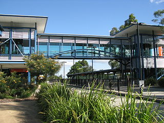
Eight Mile Plains is an outer southern suburb in the City of Brisbane, Queensland, Australia. In the 2016 census, Eight Mile Plains had a population of 15,322 people.

<span class="mw-page-title-main">Buranda busway station</span>

Buranda busway station is located in Brisbane, Australia serving the suburb of Buranda. It opened on 30 April 2001 when the South East Busway was extended from Woolloongabba to Eight Mile Plains.

<span class="mw-page-title-main">Greenslopes busway station</span>

Greenslopes busway station is located in Brisbane, Australia serving the suburb of Greenslopes.

<span class="mw-page-title-main">Holland Park West busway station</span>

Holland Park West busway station is located in Brisbane, Australia serving the suburb of Holland Park West. It opened on 30 April 2001 when the South East Busway was extended from Woolloongabba to Eight Mile Plains.

<span class="mw-page-title-main">Griffith University busway station</span>

Griffith University Busway Station located in Brisbane, Australia serving the Griffith University, Mount Gravatt and Nathan campuses. It opened on 30 April 2001 when the South East Busway was extended from Woolloongabba to Eight Mile Plains.

<span class="mw-page-title-main">Eight Mile Plains busway station</span>

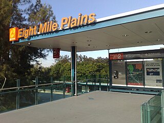
Eight Mile Plains busway station is the southernmost station on the South East Busway in Brisbane, Australia serving the suburb of Eight Mile Plains. It opened on 30 April 2001 when the busway was extended from Woolloongabba.

<span class="mw-page-title-main">Upper Mount Gravatt busway station</span> Brst service best area i love it easy to catch the bus for south east Queensland

Upper Mount Gravatt busway station is located in Brisbane, Australia serving the suburb of Upper Mount Gravatt. It opened on 30 April 2001 when the South East Busway was extended from Woolloongabba to Eight Mile Plains.

<span class="mw-page-title-main">Springwood bus station</span>

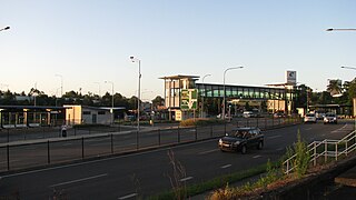
The Springwood Bus Station, in Springwood, is serviced by Translink bus routes. It is a major interchange for TransLink's Southern Region, being an important stop for Logan City Bus Service routes between Brisbane and Loganholme. The architecture of the station is based upon the steel and glass designs of Brisbane's busway stations. It is in Zone 2 of the Translink integrated public transport system.

The M1 in, Queensland, Australia, is a major urban road corridor. It connects the Sunshine Coast hinterland to Tugun, near the New South Wales and Queensland border, via the following corridors:

<span class="mw-page-title-main">Rochedale South, Queensland</span> Suburb of Logan City, Queensland, Australia

Rochedale South is a northern residential suburb in the City of Logan, Queensland, Australia. In the 2016 census, Rochedale South had a population of 15,317 people.

<span class="mw-page-title-main">Underwood, Queensland</span> Suburb of Logan City, Queensland, Australia

Underwood is a suburb in the City of Logan, Queensland, Australia. In the 2016 census, Underwood had a population of 6,341 people.

<span class="mw-page-title-main">Transport in Brisbane</span>

Transport in Brisbane, the capital and largest city of Queensland, Australia, is provided by road, rail, river and bay ferries, footpaths, bikepaths, sea and air.

The Rochedale Busway Station is a proposed Busway Station to be built in Queensland Australia at Rochedale near Underwood Road as part of an extension to the South East Busway, planned to be completed in 2024. The station will be served by Translink bus routes. It will be the station between the existing Eight Mile Plains Station and Springwood Bus Station.

<span class="mw-page-title-main">Cross River Rail</span> Proposed railway line in Brisbane, Australia

Cross River Rail is an underground heavy rail project currently under construction in Brisbane, Australia. The project will see the development of a new rail line underneath Brisbane River, and the redevelopment of a number of stations in the Brisbane central business district and along the Beenleigh railway line. The business case for the project was released in August 2017, with construction work officially beginning in September that year. The project replaced the planned 2013 BaT Tunnel, which in turn had replaced the original 2010 Cross River Rail proposal.

<span class="mw-page-title-main">Busways in Brisbane</span>

Since the mid-1990s, a 27 kilometre bus rapid transit network has been developed in Brisbane, Australia. It comprises grade-separated bus-only corridors, complementing the Queensland Rail City network. Management of the busway network is the responsibility of TransLink as coordinator of South East Queensland's integrated public transport system.

The BaT (Bus and Train) project was a proposed north–south tunnel that would provide bus and rail modes of transportation by combining a new underground rail line and busway in a single, double-decked, 15m-wide tunnel beneath the Brisbane River and Brisbane central business district. The tunnel was to have three underground stations at Woolloongabba, George Street and Roma Street with Dutton Park upgraded.

<span class="mw-page-title-main">Dutton Park Place busway station</span> Bus station in Brisbane, Australia

Dutton Park Place busway station is located in Brisbane, Australia serving the suburb of Dutton Park. It is the penultimate westbound stop on the Eastern Busway.

<span class="mw-page-title-main">Brisbane Metro</span> Planned bus service for Brisbane, Australia

Brisbane Metro is a planned high-frequency bus rapid transit system that will service Brisbane, Australia. It will consist of two routes that will run through the Brisbane central business district (CBD) every three minutes during peak times (20vph), transporting up to 3,000 passengers per hour in each direction.

References

  1. "Melbourne buses: How do other cities compare?". abc.net.au. ABC News. 16 February 2017. Archived from the original on 24 October 2021. Retrieved 24 October 2021.
  2. 1 2 Mulley, Corinne; Ma, Liang; Clifton, Geoffrey; Yen, Barbara; Burke, Matthew (June 2016). "Residential property value impacts of proximity to transport infrastructure: An investigation of bus rapid transit and heavy rail networks in Brisbane, Australia". Journal of Transport Geography. 54: 43. doi:10.1016/j.jtrangeo.2016.05.010. hdl: 10072/142793 . Archived from the original on 7 January 2022. Retrieved 7 January 2022.
  3. "Integrated Regional Transport Plan". Queensland Government, Department of Transport and Main Roads. Archived from the original on 16 March 2011. Retrieved 11 March 2011.
  4. "South East Busway, Brisbane". Road Traffic Technology. Archived from the original on 15 July 2011. Retrieved 11 March 2011.
  5. "Integrated Regional Transport Plan (Part 1)" (PDF). Queensland Government, Department of Transport and Main Roads. p. 29 (PDF page 46). Archived from the original (PDF) on 16 March 2011. Retrieved 11 March 2011.
  6. Bridge changes slammed The Courier-Mail 14 December 2000
  7. South East Busway services to start on Monday Archived 18 March 2017 at the Wayback Machine Queensland Government 22 October 2000
  8. "Busways". Queensland Government, Department of Transport and Main Roads. Archived from the original on 14 August 2012. Retrieved 11 March 2011.
  9. Shunter, Loose (30 October 2010). "A decade of Australian Public Transport Projects". TransportTextbook. Archived from the original on 28 November 2010. Retrieved 11 March 2011.
  10. South-east Queensland transport infrastructure rollout since 1975 Archived 5 January 2017 at the Wayback Machine Brisbane Times 6 July 2010
  11. Brisbane busway turns 10 Archived 18 March 2017 at the Wayback Machine Australasian Bus & Coach 3 May 2011
  12. Main Roads Pacific Motorway Transit Project Archived 2009-06-18 at the Wayback Machine
  13. Translink South East Busway Extension Archived 2009-04-25 at the Wayback Machine
  14. "South East Busway Extension". Queensland Government. Archived from the original on 11 June 2010. Retrieved 25 July 2010.
  15. "Gateway Upgrade South and South East Busway Extension Newsletter" (PDF). Queensland Government, Department of Transport and Main Roads. 15 February 2012. Archived (PDF) from the original on 20 December 2013. Retrieved 31 December 2012.
  16. "Gateway Upgrade South (GUS) project and South East Busway extension". Queensland Government, Department of Transport and Main Roads. Archived from the original on 1 January 2015. Retrieved 1 January 2015.
  17. "South East Busway extension alignment map" (PDF). Queensland Government, Department of Transport and Main Roads. 15 July 2010. Archived (PDF) from the original on 6 April 2015. Retrieved 31 December 2012.
  18. "Pacific Motorway, Eight Mile Plains to Daisy Hill Upgrade". Department of Transport and Main Roads. Archived from the original on 1 October 2021. Retrieved 1 October 2021.
  19. "South East Transit Project". The Harrison Group. 2007. Archived from the original on 27 May 2011. Retrieved 11 March 2011.
  20. "South Eastern Busway Network Map" (PDF). Translink . January 2017.

Commons-logo.svg Media related to South East Busway at Wikimedia Commons

27°30′29″S153°02′20.4″E / 27.50806°S 153.039000°E / -27.50806; 153.039000