Cultural Centre busway station

Last updated

Cultural Centre
Cultural Center busway station Melbourne St South Brisbane P1220344.jpg
Southbound view in March 2012
General information
LocationMelbourne Street, South Brisbane
Coordinates 27°28′24″S153°01′09″E / 27.47333°S 153.01917°E / -27.47333; 153.01917 Coordinates: 27°28′24″S153°01′09″E / 27.47333°S 153.01917°E / -27.47333; 153.01917
Owned by Department of Transport & Main Roads
Operated by Clarks Logan City Bus Service
Transport for Brisbane
Line(s) South East Busway
Northern Busway
Platforms3 [lower-alpha 1]
Bus routes70
Connections South Brisbane railway station
Construction
Disabled accessYes
Other information
Station code 010802 (platform 1)
011168 (platform 2)
Fare zone go card 1
Website Translink
History
Opened23 October 2000
Rebuilt25 October 2004
Services
Preceding station Translink Following station
Queen Street
Terminus
South East Busway South Bank
Terminus Northern Busway King George Square
towards Kedron Brook

Cultural Centre busway station is located in Brisbane, Australia serving the South Bank precinct. It is located directly south of Victoria Bridge and close to South Brisbane railway station.

Contents

The station takes its name from its location within the Queensland Cultural Centre precinct. The platforms are accessible from the pedestrian bridge linking the Queensland Performing Arts Centre to the Queensland Museum and Queensland Art Gallery. The station is also close to the Brisbane Convention & Exhibition Centre, Queensland Conservatorium Griffith University, South Bank Piazza and the western end of the South Bank Parklands.

History

Cultural Centre busway station opened on 23 October 2000 when the South East Busway opened to Woolloongabba. [2] When built, it only had one lane in each direction with no ability for buses to pass. In March 2003 work commenced to alleviate this with the platforms set back to allow for a passing lane in each direction. [3] [4] Some materials from the original station were reused in the construction of Capalaba bus station. The work was completed in October 2004. [5] [6]

Services

The station services buses to the southern suburbs and South East Busway as well as providing an alternative terminus to the Brisbane central business district for many bus services from northern suburbs including those operating via the Northern Busway. Many CityXpress and most BUZ routes pass through the station, providing convenient transfer to and from major servicing areas outside the city. It is served by 70 routes operated by Clarks Logan City Bus Service and Transport for Brisbane as part of the Translink network. [7]

Northern Busway services

No Northern Busway services directly connect King George Square busway station with the Queen Street bus station. After stopping at Cultural Centre station, a number of outbound (northbound) services bypass the Queen Street bus station and stop at the King George Square on the northern side of the Brisbane River and vice versa.

Platforms

Services depart as follows:

Platform 1

● Inbound Services from South East Busway, West End & UQ Lakes busway station to City & Fortitude Valley
● Outbound services to Northern Suburbs via the Northern Busway
StopRouteDestination / descriptionNotes
[010802] 60 to Teneriffe ferry wharf via Adelaide Street & Fortitude Valley station [8] Blue CityGlider
61 to Ashgrove via Roma Street busway station & Paddington [9] Maroon CityGlider
66to RBWH busway station via Roma Street busway station [10]
100, 110, 115, 120, 130, 135, 140, 150, 160, 170, 180, 200, 214, 215, 220,to Queen Street bus station [11] [12] [13] [14] [15] [16] [17] [18] [19] [20] [21] [22] [23] [24] [25]
105, 107, 108, 112, 113, 172, 202to Eagle Street via Elizabeth Street [26] [27] [28] [29] [30] [31] [32]
124, 125, 174, 175, 203, 204, 230, 235, N555to Fortitude Valley via Adelaide Street [33] [34] [35] [36] [37] [38] [39] [40] [41]
184, 185, 210, 212to Fortitude Valley via Elizabeth Street [42] [43] [44] [45]
111, 222to Roma Street busway station [46] [47]
116to Wickham Terrace via Adelaide Street [48]
192to Adelaide Street [49]
196 New Farm via Adelaide Street & Fortitude Valley station [50] BUZ service
199, N199 Teneriffe ferry wharf via Adelaide Street & Fortitude Valley station [51] [52] 199 BUZ service
N199 NightLink service
300to Toombul bus interchange via Fortitude Valley, Newstead, Kingsford Smith Drive, Hamilton & Hendra station [53]
301to Toombul bus interchange via St Paul's Terrace, Bowen Hills, Albion, Ascot station & Hendra [54]
306to Nudgee Beach via Fortitude Valley, Newstead, Sandgate Road, Toombul bus interchange, Northgate & St Vincents Road [55]
322to Chermside bus station via Fortitude Valley, Newstead, Sandgate Road, Toombul bus interchange & Wavell Heights [56]
330to Bracken Ridge via Northern Busway, Chermside bus station, Hanford Road & Norris Road [57] BUZ service
345to Aspley via Kelvin Grove Road, Alderley, Appleby Road & Maundrell Terrace [58] BUZ service
385to The Gap via Paddington, Bardon & Waterworks Road [59] BUZ service
444to Moggill via Coronation Drive, Toowong, Indooroopilly bus station, Moggill Road, Kenmore Village & Pinjarra Hills [60] BUZ service
555to Elizabeth Street [61]

Platform 2

● Outbound Services from Fortitude Valley & the City to Southern and Eastern Suburbs, West End & UQ Lakes busway station
● Outbound Services from City to Western Suburbs
● Terminating services from Northern Suburbs via the Northern Busway
StopRouteDestination / descriptionNotes
[011168] 60 to West End ferry wharf [8] Blue CityGlider
61 to Coorparoo via Woolloongabba busway station, Stones Corner busway station [9] Maroon CityGlider
66to UQ Lakes busway station via Boggo Road busway station [10]
100to Forest Lake via Ipswich Road, Durack & Inala bus station [11] BUZ service
105to Indooroopilly bus station via Boggo Road busway station, Yeronga, Yeerongpilly station, Tennyson & Graceville Avenue [26]
107to Yeronga via Boggo Road busway station & Fairfield Road [27]
108to Indooroopilly bus station via Boggo Road busway station, Fairfield Road, Yeerongpilly startion, Tennyson & Graceville Avenue [28]
110to Inala bus station via Ipswich Road, Beaudesert Road, Acacia Ridge & Inala Avenue [12]
111, N111to Eight Mile Plains busway station via South East Busway [46] 111 BUZ service
N11 NightLink service
112to Griffith University Mount Gravatt Campus via Annerley Road & Tarragindi [29]
113to Mount Gravatt East via Ipswich Road, Tarragindi & Nursery Road [30]
115to Calamvale via Ipswich Road, Beaudesert Road, Archerfield, Acacia Ridge & Sunnybank Hills [13]
116to Rocklea station via Annerley Road, Glendale Crescent & Moorooka station [48]
120to Garden City bus station via Tarragindi, Coopers Plains & Griffith University Nathan Campus [14] BUZ service
124to Sunnybank Plaza via Ipswich Road, Beaudesert Road, Salisbury & Coopers Plains [33]
125to Garden City bus station via Ipswich Road, Beaudesert Road, Salisbury, Coopers Plains & Griffith University Nathan Campus [34]
130, N130to Parkinson via South East Busway, Mains Road & Algester [15] 130 BUZ service
N130 NightLink service
135to Parkinson via South East Busway, Griffith University Nathan Campus, Sunnybank, Sunnybank Hills & Algester [16]
140to Browns Plains bus station via South East Busway, Mains Road & Beaudesert Road [17] BUZ service
150to Browns Plains bus station via South East Busway, Runcorn & Calamvale [18] BUZ service
160to Garden City bus depot via South East Busway [19]
170to Garden City bus station via South East Busway, Logan Road & Newnham Road [20]
172to Garden City bus station via Woolloongabba busway station, Greenslopes Hospital, Holland Park, Mount Gravatt East & Logan Road [31]
174to Garden City bus station via Woolloongabba busway station, Logan Road & Newham Road [35]
175to Garden City bus station via Woolloongabba busway station & Logan Road [36]
180to Garden City bus station via Greenslopes, Cavendish Road, Mansfield & Wishart [21] BUZ service
184, N184to Garden City bus station via Coorparoo, Cavendish Road, Holland Park, Mount Gravatt East & Wemvern Street [42] [62] N184 NightLink service
185to Garden City bus station via Coorparoo, Cavendish Road, Mansfield & Wishart [43]
192to UQ Lakes busway station via West End, Highgate Hill & Dutton Park [49]
196to Fairfield via Gladstone Road & Dutton Park [50] BUZ service
199, N199to West End via Hardgrave Road [51] 199 BUZ service
N199 NightLink service
200, N200to Carindale Heights via Woolloongabba busway station, Old Cleveland Road & Carindale bus station [22] [63] 200 BUZ service
N200 NightLink service
202to Carindale bus station via PA Hospital, Chatsworth Road, Camp Hill & Carina Heights [32]
203to Carindale bus station via Woolloongabba busway station, Old Cleveland Road, Camp Hill & Carina Heights [37]
204to Carina High School via Woolloongabba busway station, Old Cleveland Road, Carina Heights & Carindale bus station [38]
210to Cannon Hill bus station via Coorparoo, Norman Park, Stanley Road & Carina [44]
212to Carindale bus station [45]
214to Cannon Hill bus station via Coorparoo, Norman Park & Richmond Road [23]
215to Carindale bus station via Coorparoo, Norman Park, Richmond Road, Cannon Hill bus station, Tingalpa & Belmont Road [24]
220to Wynnum Beach via Coorparoo, Norman Park, Richmond Road, Cannon Hill bus station, Tingalpa, Manly West & Wynnum Road [25]
222to Carindale bus station via Eastern Busway & Old Cleveland Road [47] BUZ service
230to Bulimba via East Brisbane, Wynnum Road & Riding Road [39]
235to Bulimba via East Brisbane, Wynnum Road & Morningside [40]
555to Loganholme bus station via South East Busway, Eight Mile Plains busway station, Pacific Motorway & Springwood bus station [61] BUZ service
N100to Richlands station via Ipswich Road, Durack, Inala bus station & Forest Lake NightLink service
N226to Wynnum West via East Brisbane, Wynnum Road, Hawthorne, Balmoral, Cannon Hill, Tingalpa, Manly West & Wynnum Beach. NightLink service
N250to Capalaba via Old Cleveland Road, Carindale, Finucane Road, Cleveland Redland Bay Road & Redland Bay Road NightLink service
N339to Bracken Ridge via Northern Busway, Chermside, Zillmere & Taigum [64] NightLink service
N345to Aspley via Kelvin Grove Road, Alderley, Appleby Road & Chermside West [65] NightLink service
N385to The Gap via Paddington & Ashgrove [66] BUZ service
N555to Loganholme bus station via South East Busway, Upper Mount Gravatt busway station, Eight Mile Plains busway station, Springwood bus station & Daisy Hill [41] NightLink service

Facilities

A pedestrian bridge towards the south of the station, which provide access to the platforms, connects the Queensland Performing Arts Centre with both the Queensland Museum and the Queensland Art Gallery. The elevated pedestrian bridge has three lifts.

There is a giant-size model of a cicada right outside Platform 2 of the station.

Notes

  1. Originally 2 platforms. As of 15 August 2022, the outbound platform was closed until late 2023 to allow for Brisbane Metro construction works. Two temporary platforms were opened further west along Melbourne Street. [1]

Related Research Articles

<span class="mw-page-title-main">Roma Street railway station</span> Railway station in Brisbane, Queensland

Roma Street railway station is located in the Brisbane central business district, Queensland, Australia. It is the junction station for the North Coast, Main, Gold Coast and NSW North Coast lines. The station is one of four inner city stations that form a core corridor through the centre of Brisbane.

<span class="mw-page-title-main">Northgate railway station, Brisbane</span> Railway station in Brisbane, Queensland, Australia

Northgate railway station is located on the North Coast line in Queensland, Australia. It serves the Brisbane suburb of Northgate. Immediately north of the station, the Shorncliffe line branches off.

<span class="mw-page-title-main">Zillmere railway station</span> Railway station in Brisbane, Queensland, Australia

Zillmere railway station is located on the North Coast line in Queensland, Australia. It serves the Brisbane suburb of Zillmere.

<span class="mw-page-title-main">South Brisbane railway station</span> Historic site in Queensland, Australia

South Brisbane railway station is a heritage-listed railway station at 133 Grey Street, South Brisbane, City of Brisbane, Queensland, Australia. It is one of two stations serving the South Brisbane area, the other being South Bank. It was built from 1891 to 1918, making it the second oldest railway station in central Brisbane. It is also known as Cultural Centre Station, Melbourne Street Station, and South Brisbane (Interstate) Station. It was added to the Queensland Heritage Register on 21 October 1992.

<span class="mw-page-title-main">South Bank railway station, Brisbane</span> Railway station in Brisbane, Queensland, Australia

South Bank railway station is located on the Gold Coast line in Brisbane, Queensland, Australia. It is one of two stations serving the South Brisbane area, the other being South Brisbane station. It was formerley known as Vulture Street station due to being located on Vulture Street.

<span class="mw-page-title-main">South East Busway</span>

The South East Busway is a grade separated bus-only road running south from the Brisbane central business district to Eight Mile Plains in Queensland, Australia. The busway was completed to Woolloongabba in September 2000 and to Eight Mile Plains in April 2001. An extension of the busway to School Road at Rochedale was completed in 2014 with no additional busway stations. The maximum capacity of the busway is 18,000 commuters an hour during peak periods. The busway carries an estimated 70 million passengers annually.

The Northern Busway is a bus-only road running north from the Brisbane central business district to the Royal Brisbane & Women's Hospital in Queensland, Australia. The first section of the busway opened on 23 February 2004 with one station at QUT Kelvin Grove. In December 2005, Normanby and Herston stations opened.

The Eastern Busway is a bus-only road running from the University of Queensland's St Lucia campus to Langlands Park busway station in Queensland, Australia.

<span class="mw-page-title-main">Queen Street bus station</span> Bus station in Brisbane, Queensland

Queen Street bus station is the primary bus terminus in Brisbane central business district in Queensland, Australia. It is underneath The Myer Centre and Queen Street Mall. It opened on 26 March 1988. At the time it was the largest underground diesel bus station in the world.

<span class="mw-page-title-main">King George Square busway station</span>

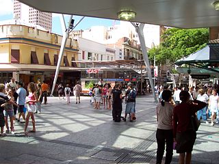
King George Square busway station is located in Brisbane, Queensland, Australia serving the Brisbane central business district. It is located beneath King George Square and marks the start of the Northern Busway. The station has twelve stops on two platforms; access to these platforms is via an underground concourse which can be accessed from Ann Street or Adelaide Street. Passengers wait behind automatic doors on the stop that is assigned to their bus. It opened on 19 May 2008.

<span class="mw-page-title-main">Ipswich railway station, Queensland</span> Railway station in Brisbane, Queensland, Australia

Ipswich railway station is located on the Main line in Queensland, Australia. It serves the urban centre of Ipswich.

<span class="mw-page-title-main">South Bank busway station</span>

South Bank busway station is located in Brisbane, Australia serving the suburb of South Brisbane. It opened on 23 October 2000 when the South East Busway opened from the Cultural Centre to Woolloongabba.

<span class="mw-page-title-main">Mater Hill busway station</span>

Mater Hill busway station is located in Brisbane, Australia serving the suburb of South Brisbane. It opened on 23 October 2000 when the South East Busway opened from the Cultural Centre to Woolloongabba. It is surrounded by Mater Health Services, from which the station derives its name.

<span class="mw-page-title-main">Indooroopilly bus station</span>

The Indooroopilly bus station, also known as the Indooroopilly Interchange, is a major TransLink bus stop servicing the western suburbs of Brisbane. The interchange forms part of the Indooroopilly Shopping Centre and is a major interchange for inner-city bus lines. It is in a transition precinct between Zone 1 and Zone 2 of the public transport system. Indooroopilly train station is located within walking distance from Indooroopilly.

<span class="mw-page-title-main">Bretts Wharf</span>

Bretts Wharf is a ferry terminal on the northern bank of the Brisbane River in the suburb of Hamilton in the City of Brisbane, Queensland, Australia. It serves patrons from nearby Racecourse Road and Portside Wharf, as well as visitors to Eagle Farm Racecourse and Doomben Racecourse in the Brisbane suburbs of Hamilton and Ascot. Bretts Wharf was the terminus for downstream CityCat services until Apollo Road reopened in February 2008. It is served by RiverCity Ferries' CityCat services.

<span class="mw-page-title-main">Transport in Brisbane</span>

Transport in Brisbane, the capital and largest city of Queensland, Australia, is provided by road, rail, river and bay ferries, footpaths, bikepaths, sea and air.

The Aspley Bus Station, at Aspley, Queensland, Australia, is served by TransLink bus routes. It is part of the Aspley Hypermarket Shopping Centre. It is in Zone 2 of the TransLink integrated public transport system.

<span class="mw-page-title-main">Busways in Brisbane</span>

Since the mid-1990s, a 27 kilometre bus rapid transit network has been developed in Brisbane, Australia. It comprises grade-separated bus-only corridors, complementing the Queensland Rail City network. Management of the busway network is the responsibility of TransLink as coordinator of South East Queensland's integrated public transport system.

<span class="mw-page-title-main">Springfield Central railway station</span> Railway station in Queensland, Australia

Springfield Central Railway Station is the terminus station of the Springfield Line in Queensland, Australia. It serves Springfield Central and other nearby suburbs in the City of Ipswich. Brisbane-bound services depart half-hourly during off-peak times, with most travelling to Kippa-Ring. The station was opened in December 2013 after the line was extended from Richlands.

<span class="mw-page-title-main">Dutton Park Place busway station</span> Bus station in Brisbane, Australia

Dutton Park Place busway station is located in Brisbane, Australia serving the suburb of Dutton Park. It is the penultimate westbound stop on the Eastern Busway.

References

  1. Cultural Centre station platform 2 - temporary closure Translink
  2. South East Busway services to start on Monday Minister for Transport & Main Roads 22 October 2000
  3. Cultural Centre Busway Station Fleetline issue 284 June 2003 page 81
  4. Cultural Centre busway station Transit Australia June 2003 page 164
  5. Cultural Centre Bus station revamped Australasian Bus & Coach November 2004 page 12
  6. South East Busway Transit Australia January 2005 page 20
  7. Cultural Centre Station Translink
  8. 1 2 "Route 60 Timetable" (PDF).
  9. 1 2 "Route 61 Timetable" (PDF).
  10. 1 2 "Route 66 Timetable" (PDF).
  11. 1 2 "Route 100 Timetable" (PDF).
  12. 1 2 "Route 110 Timetable" (PDF).
  13. 1 2 "Route 115 Timetable" (PDF).
  14. 1 2 "Route 120 Timetable" (PDF).
  15. 1 2 "Route 130 Timetable" (PDF).
  16. 1 2 "Route 135 Timetable" (PDF).
  17. 1 2 "Route 140 Timetable" (PDF).
  18. 1 2 "Route 150 Timetable" (PDF).
  19. 1 2 "Route 160 Timetable" (PDF).
  20. 1 2 "Route 170 Timetable" (PDF).
  21. 1 2 "Route 180 Timetable" (PDF).
  22. 1 2 "Route 200 Timetable" (PDF).
  23. 1 2 "Route 214 Timetable" (PDF).
  24. 1 2 "Route 215 Timetable" (PDF).
  25. 1 2 "Route 220 Timetable" (PDF).
  26. 1 2 "Route 105 Timetable" (PDF).
  27. 1 2 "Route 107 Timetable" (PDF).
  28. 1 2 "Route 108 Timetable" (PDF).
  29. 1 2 "Route 112 Timetable" (PDF).
  30. 1 2 "Route 113 Timetable" (PDF).
  31. 1 2 "Route 172 Timetable" (PDF).
  32. 1 2 "Route 202 Timetable" (PDF).
  33. 1 2 "Route 124 Timetable" (PDF).
  34. 1 2 "Route 125 Timetable" (PDF).
  35. 1 2 "Route 174 Timetable" (PDF).
  36. 1 2 "Route 175 Timetable" (PDF).
  37. 1 2 "Route 203 Timetable" (PDF).
  38. 1 2 "Route 204 Timetable" (PDF).
  39. 1 2 "Route 230 Timetable" (PDF).
  40. 1 2 "Route 235 Timetable" (PDF).
  41. 1 2 "Route N555 Timetable" (PDF).
  42. 1 2 "Route 184 Timetable" (PDF).
  43. 1 2 "Route 185 Timetable" (PDF).
  44. 1 2 "Route 210 Timetable" (PDF).
  45. 1 2 "Route 212 Timetable" (PDF).
  46. 1 2 "Route 111 Timetable" (PDF).
  47. 1 2 "Route 222 Timetable" (PDF).
  48. 1 2 "Route 116 Timetable" (PDF).
  49. 1 2 "Route 192 Timetable" (PDF).
  50. 1 2 "Route 196 Timetable" (PDF).
  51. 1 2 "Route 199 Timetable" (PDF).
  52. "Route N199 Timetable" (PDF).
  53. "Route 300 Timetable" (PDF).
  54. "Route 301 Timetable" (PDF).
  55. "Route 306 Timetable" (PDF).
  56. "Route 322 Timetable" (PDF).
  57. "Route 330 Timetable" (PDF).
  58. "Route 345 Timetable" (PDF).
  59. "Route 385 Timetable" (PDF).
  60. "Route 444 Timetable" (PDF).
  61. 1 2 "Route 555 Timetable" (PDF).
  62. "Route N184 Timetable" (PDF).
  63. "Route N200 Timetable" (PDF).
  64. "Route N339 Timetable" (PDF).
  65. "Route N345 Timetable" (PDF).
  66. "Route N385 Timetable" (PDF).

Commons-logo.svg Media related to Cultural Centre busway station at Wikimedia Commons