South Bank Parklands

Last updated

South Bank Parklands
Streets Beach at South Bank Parklands, Brisbane 03.jpg
Streets Beach and Grand Arbour, South Bank Parklands
South Bank Parklands
LocationSouth Brisbane, Brisbane, Queensland, Australia
Coordinates 27°28′43″S153°01′22″E / 27.4787°S 153.0229°E / -27.4787; 153.0229
Area17.5 hectares (0.068 sq mi)
Opened20 June 1992 (1992-06-20) [1]
Open5:00 am - midnight
StatusOpen all year
Parking800 spaces
Public transit accessTrain, bus and ferry
Website www.visitsouthbank.com.au

The South Bank Parklands are located at South Bank within the suburb of South Brisbane in Brisbane, Queensland, Australia. The parkland, on the transformed site of Brisbane's World Expo 88, was officially opened to the public on 20 June 1992. [1]

Contents

The South Bank Parklands are located on the southern bank of the Brisbane River, at South Bank, directly opposite the City. The parklands are connected to the City by the Victoria Bridge at the northern end, and to Gardens Point by the Goodwill Bridge at the southern end.

The parklands consist of a mixture of rainforest, water, grassed areas and plazas as well as features such as the riverfront promenade, the Streets Beach, the Grand Arbour, the Courier Mail Piazza, the Nepalese Peace Pagoda, the Wheel of Brisbane, restaurants, shops and fountains. The parklands are also home to the Queensland Conservatorium.

South Bank and its parklands are one of Brisbane's most important cultural precincts and they regularly host large scale festivals and events. An estimated 14 million people visit the parklands each year. [2]

History

South Bank was originally a meeting place for the traditional landowners, the Turrbal and Yuggera people and, in the early 1840s it became the central focus point of early European settlement. From the 1850s, South Bank Precinct was quickly established as the business centre of Brisbane. However, this was all disrupted when the 1893 Brisbane floods forced the central business district to shift to the northern side of the river and attain higher ground. This is where the Brisbane central business district still stands today. This began the decline of South Bank, and the area became home to vaudeville theatres, derelict boarding houses, and light and heavy industry. [3]

The 1970s marked the beginnings of a new era, with parkland reclaimed along the river bank, and the Queensland Cultural Centre was built which included the Queensland Art Gallery, the Queensland Museum, the Queensland Performing Arts Centre and State Library of Queensland (today it also includes the Queensland Gallery of Modern Art).

A panoramic view of Streets Beach Streetsbeachsouthbankparklands.jpg
A panoramic view of Streets Beach

In 1988, Brisbane held a successful World Expo 88, following which the Government intended to develop the site for commercial interests. However, a public campaign successfully lobbied for the site to be redeveloped as parkland for the enjoyment of people in Brisbane. In 1989, the South Bank Corporation, a Queensland Government statutory body, was established to oversee the development and management of the new South Bank Parklands. [4]

When South Bank Parklands were developed following World Expo 88, there was a system of canals and bridges. Southship operated small boats which travelled along the canals. [5] They stopped operating in 1997 and the canals were removed as part the 1998 redevelopment. [6] [7]

Butterfly Island enclosure of the former Butterfly House Butterfly-House.jpg
Butterfly Island enclosure of the former Butterfly House

Our World Environment was a walk through attraction that included a recreation of Mawson's Huts. [5] It closed in 1994. [6]

There were also a wildlife refuge called Gondwana Rainforest Sanctuary as well as a Butterfly House. In January 1998, Gondwana Rainforest Sanctuary was closed down and the animals relocated. In April 1998, the Butterfly and Insect House was renamed as South Bank Wildlife Sanctuary, with the introduction of other wildlife. In the latter half of 2005, the South Bank Wildlife Sanctuary was closed and dismantled and an office and retail store were built on the South Bank Wildlife Sanctuary's former location.[ citation needed ]

Visitors were originally able to hire golf carts to tour the grounds as well. This attraction was also phased out with Gondwana Rainforest Sanctuary and the canals.[ citation needed ]

In 1998, a major redevelopment was announced that included the Goodwill Bridge, Grey Street, Grand Arbour and improvements to accessibility via removal of the canals and associated pathways. [8]

In 2009, as part of the Q150 celebrations, South Bank Parklands was announced as one of the Q150 Icons of Queensland for its role as a "location". [9]

The popular Boardwalk restaurants clustered at the southern end of the grounds, built for Expo 88, were demolished between 2009-13 and replaced with other restaurants along Clem Jones Promenade near the Goodwill Bridge. [10]

In 2013, the South Bank Corporation contracted the Brisbane City Council to provide maintenance services and to manage the public green spaces, while Brisbane Marketing (a subsidiary of the council) manages the marketing and events. The Corporation retains responsibility for the commercial tenants, the carpark and the renewal planning. [11]

The Goodwill Bridge connecting the South Bank Parklands to Gardens Point Goodwilla bridgey.jpg
The Goodwill Bridge connecting the South Bank Parklands to Gardens Point

Access and transport

Walking

The South Bank Parklands can be accessed from South Bank via Vulture Street, Little Stanley Street and the Cultural Forecourt; from the City via the Victoria Bridge; from Gardens Point via the Goodwill Bridge; and from Kangaroo Point via the Riverwalk.

Public transport

The South Bank Parklands are within walking distance of the Cultural Centre busway station and the South Bank busway station, as well as the South Brisbane railway station and South Bank railway station. There are three CityCat terminals on the Brisbane River, near the Victoria Bridge.

Bicycle

Bicycles can access the Brisbane, South Bank Parklands from South Bank via Vulture Street, Little Stanley Street and the Cultural Forecourt; from Gardens Point via the Goodwill Bridge; and from Kangaroo Point via the Riverwalk. Bicycle racks are located at the Visitors Centre in Stanley Street Plaza, Suncorp Piazza, The Boardwalk, Clem Jones Promenade and Little Stanley Street.

The South Bank Arbour at the northern entrance to the South Bank Parklands, 2005 South-Bank-Parklands-Arbour.jpg
The South Bank Arbour at the northern entrance to the South Bank Parklands, 2005

Attractions

The Arbour

The Arbour consists of 443 curling steel columns covered in bougainvilleas which flower throughout the year. The arbour stretches for 1 kilometre (0.62 mi) from Vulture Street to the Cultural Forecourt and is used as a pedestrian walkway. [12]

South Bank Piazza

The South Bank Piazza (formerly Suncorp Piazza and Courier Mail Piazza) is an open-air amphitheater which is frequently used for community events. It has a seating capacity of 2,158. When not in use, the Piazza displays news and sports on two suspended screens. [13]

Wheel of Brisbane at dusk Wheel offa brisbane.jpg
Wheel of Brisbane at dusk

Wheel of Brisbane

The Wheel of Brisbane is a 60-metre (197 ft) tall Ferris wheel erected at the parklands in August 2008 to celebrate the 20th Anniversary of World Expo 88 and 150th Anniversary of Queensland 1859–2009. It carries 42 gondolas on a 15-minute ride with panoramic views of the South Bank Parklands, the Brisbane River, and the City. [14]

The Nepalese Peace Pagoda at night Nepalese Peace Pagoda Southbank Parklands South Brisbane P1100342.jpg
The Nepalese Peace Pagoda at night

Nepalese Peace Pagoda

The Nepalese Peace Pagoda was originally located on the Expo site and was moved to its new South Bank Parklands riverfront location at the conclusion of the Expo after a successful government and private fundraising campaign to keep the Pagoda in Brisbane. It has traditional Nepali architecture and art work and features a meditation area.

Streets Beach

Streets Beach Streets Beach.jpg
Streets Beach
Fountains at the entrance to South Bank Parklands -- (photo taken during the 1990s) Fountains-at-entrance-to-South-Bank.jpg
Fountains at the entrance to South Bank Parklands (photo taken during the 1990s)

A major feature within the parkland is its man-made beach in the form of a lagoon, which is 2,000 square metres (22,000 sq ft) of free-formed concrete surrounded by 2,000 cubic metres (71,000 cu ft) of sand. The sand surrounding the beach is sourced from the Rous Channel in Moreton Bay and every year the beach is topped up with an additional 70 tonnes (69 long tons; 77 short tons) to ensure that it is kept in pristine condition. Almost half of the lagoon area sits on reclaimed land that was once the Brisbane River.[ citation needed ]

The beach was designed by Desmond Brookes International and was constructed by Fletcher Jennings Construction and Water and Industrial Engineering. Construction commenced in February 1991 and was complete by June 1992. The lagoon contains chlorinated fresh water that is recirculated every six hours at up to 125 litres (27 imp gal; 33 US gal) per second. Water for the beach is pumped through two large sand filters and chemically treated before being pumped back into the pools. Dredge pump and self-propelled sifting machines clean the adjoining pools.[ citation needed ]

The beach has received awards including the 1999 Moreton Bay region's cleanest beach in the Keep Australia Beautiful Council's Clean Beach Challenge and the 2001 Environmental Protection Agency's Keep Australia Beautiful Clean Beach Challenge, Friendliest Beach Award. The beach area comprises a lagoon with enough water to fill five Olympic swimming pools, with sand beaches, palm trees, rocky creeks and subtropical trees and exotic plantings.[ citation needed ]

The beach is named after the sponsor Streets Ice Cream, and was formerly known as Kodak Beach. [15] The beach is patrolled year round by lifeguards. [16]

Restaurants and cafés

South Bank is a major dining precinct in Brisbane with many restaurants and cafes are situated inside the South Bank Parklands. Directly on Streets Beach, South Bank Surf Club was opened by celebrity chef Ben O'Donoghue, and features a seafood menu. Immediately adjacent is Live Fire Steak Bar, an al fresco restaurant and function space with modern décor and features craft beers. [17] [18]

Festivals and events

The South Bank Parklands host a number of annual cultural events and festivals including the Australia Day Festival, Riverfire and New Year's Eve celebrations. [19] In 2009, Riverfire drew more than half a million spectators to the South Bank Parklands. [20]

Facilities

Parking

The Parklands Underground Carpark has more than 800 car parking spaces. Access is via Tribune Street or Glenelg Street, off Little Stanley Street. [21]

Bathrooms and Showers

Showers are located in Stanley Street Plaza and there are five bathroom facilities.[ citation needed ]

Internet Connectivity

Free Wi-Fi internet access is available inside the park. Users are able to connect for up to five hours.[ citation needed ]

See also

Related Research Articles

<span class="mw-page-title-main">Brisbane River</span> River in Queensland, Australia

The Brisbane River is the longest river in South East Queensland, Australia, and flows through the city of Brisbane, before emptying into Moreton Bay on the Coral Sea. John Oxley, the first European to explore the river, named it after the Governor of New South Wales, Sir Thomas Brisbane in 1823. The penal colony of Moreton Bay later adopted the same name, eventually becoming the present city of Brisbane. The river is a tidal estuary and the water is brackish from its mouth through the majority of the Brisbane metropolitan area westward to the Mount Crosby Weir. The river is wide and navigable throughout the Brisbane metropolitan area.

<span class="mw-page-title-main">Story Bridge</span> Steel cantilever bridge in Brisbane, Queensland, Australia

The Story Bridge is a heritage-listed steel cantilever bridge spanning the Brisbane River that carries vehicular, bicycle and pedestrian traffic between the northern and the southern suburbs of Brisbane, Queensland, Australia. It is the longest cantilever bridge in Australia.

<span class="mw-page-title-main">Goodwill Bridge</span> Bridge in Queensland, Australia

The Goodwill Bridge is a pedestrian and cyclist bridge which spans the Brisbane River in Brisbane, Queensland, Australia. The bridge connects the South Bank Parklands in South Brisbane to Gardens Point in the Brisbane CBD.

<span class="mw-page-title-main">Brisbane</span> Capital city of Queensland, Australia

Brisbane is the capital of the state of Queensland and the third-most populous city in Australia and Oceania, with a population of approximately 2.6 million. Brisbane lies at the centre of South East Queensland, which includes several other regional centres and cities. The central business district is situated within a peninsula of the Brisbane River about 15 km (9 mi) from its mouth at Moreton Bay. Brisbane is located in the hilly floodplain of the Brisbane River Valley between Moreton Bay and the Taylor and D'Aguilar mountain ranges. It sprawls across several local government areas, most centrally the City of Brisbane. The demonym of Brisbane is Brisbanite.

<span class="mw-page-title-main">World Expo 88</span> Worlds fair held in Brisbane, Australia in 1988

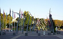
World Expo 88, also known as Expo 88, was a specialised Expo held in Brisbane, the state capital of Queensland, Australia, during a six-month period between Saturday, 30 April 1988 and Sunday, 30 October 1988, inclusive. The theme of the Expo was "Leisure in the Age of Technology", and the mascot for the Expo was an Australian platypus named Expo Oz.

<span class="mw-page-title-main">South Brisbane railway station</span> Historic site in Queensland, Australia

South Brisbane railway station is a heritage-listed railway station at 133 Grey Street, South Brisbane, City of Brisbane, Queensland, Australia. It is one of two stations serving the South Brisbane area, the other being South Bank. It was built from 1891 to 1918, making it the second oldest railway station in central Brisbane. It is also known as Cultural Centre Station, Melbourne Street Station, and South Brisbane (Interstate) Station. It was added to the Queensland Heritage Register on 21 October 1992.

<span class="mw-page-title-main">South Brisbane, Queensland</span> Suburb of Brisbane, Queensland, Australia

South Brisbane is an inner southern suburb in the City of Brisbane, Queensland, Australia. In the 2016 census, South Brisbane had a population of 7,196 people.

<span class="mw-page-title-main">Queensland Cultural Centre</span> Historic site in Queensland, Australia

The Queensland Cultural Centre is a heritage-listed cultural center on Grey Street, South Brisbane, Queensland, Australia. It is part of the South Bank precinct on the Brisbane River and was built from 1976.

<span class="mw-page-title-main">Gondwana Rainforest Sanctuary</span> Zoo in Queensland, Australia

Gondwana Rainforest Sanctuary is a former zoo at South Bank Parklands, Brisbane, Queensland, Australia. It operated from 1992 to 2005. There were about 700 animals at the sanctuary.

<span class="mw-page-title-main">Cultural Centre busway station</span> Bus station in Brisbane, Australia

Cultural Centre busway station is located in Brisbane, Australia serving the South Bank precinct. It is located directly south of Victoria Bridge and close to South Brisbane railway station.

<span class="mw-page-title-main">South Bank, Queensland</span> Precinct of Brisbane, Queensland, Australia

South Bank is a cultural, social, educational and recreational precinct in Brisbane, Queensland, Australia. The precinct is located in the suburb of South Brisbane, on the southern bank of the Brisbane River.

<span class="mw-page-title-main">Culture of Brisbane</span> Overview of the culture of Brisbane (Australia)

The culture of Brisbane derives from Australian culture and incorporates a strong history in the performing arts, music and sport.

<span class="mw-page-title-main">Brisbane central business district</span> Suburb of Brisbane, Queensland, Australia

Brisbane City is the central suburb and central business district of Brisbane, the state capital of Queensland, Australia. It is colloquially referred to as the "Brisbane CBD" or "the city". It is located on a point on the northern bank of the Brisbane River, historically known as Meanjin, Mianjin or Meeanjin in the local Aboriginal Australian dialect. The triangular shaped area is bounded by the median of the Brisbane River to the east, south and west. The point, known at its tip as Gardens Point, slopes upward to the north-west where the city is bounded by parkland and the inner city suburb of Spring Hill to the north. The CBD is bounded to the north-east by the suburb of Fortitude Valley. To the west the CBD is bounded by Petrie Terrace, which in 2010 was reinstated as a suburb.

The Queensland Maritime Museum is located on the southern bank of the Brisbane River just south of the South Bank Parklands and Queensland Cultural Centre precinct of Brisbane, and close to the Goodwill Bridge.

<span class="mw-page-title-main">South Bank Grand Arbour</span> Pergola in Brisbane, Australia

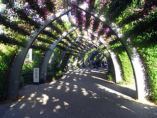
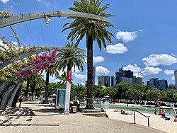
The South Bank Grand Arbour is a kilometre-long sculptural installation, located in the South Bank Parklands in Brisbane, Australia. The structure functions as a pedestrian walkway which connects the Griffith Film School on the corner of Dock Street and Vulture Street to the Cultural Forecourt adjacent to QPAC, as well as the rest of the South Bank Parklands through which it runs. The arbour follows the course of the former Expo 88 boat canal.

Stanley Street is a major street in Brisbane, Queensland. It carries the designation state route 41 for the entirety of its length and state route 10 between the Vulture Street and Annerley Road intersections. For the majority of its length the road is a one-way carriageway westbound. The route is a major connector between the Southern and Eastern suburbs and South Brisbane. The street passes directly to the south of The Gabba and runs directly through the Mater Hospital precinct.

<span class="mw-page-title-main">Tourism in Brisbane</span>

Tourism in Brisbane is an important industry for the Queensland economy, being the third-most popular destination for international tourists after Sydney and Melbourne.

<span class="mw-page-title-main">Wheel of Brisbane</span> Ferris wheel in Brisbane, Australia

The Wheel of Brisbane is an Observation Wheel in Brisbane, Queensland, Australia. It is 60 metres (197 ft) tall.

<span class="mw-page-title-main">2001 Goodwill Games</span>

The 2001 Goodwill Games was the fifth and final edition of the international multi-sport event. The competition was held in Brisbane, Queensland, Australia from 29 August to 9 September 2001. A total around 1300 athletes took part in 14 sporting competitions.

References

  1. 1 2 John Stubbs (21 June 1992). "Brisbane's $100M Oasis Opens". The Sun-Herald (Queensland ed.). Sydney, Australia. p. 3. Archived from the original on 31 January 2022. Retrieved 21 May 2014.
  2. "About South Bank | Visit Brisbane, Australia". visit.brisbane.qld.au. Archived from the original on 31 January 2024. Retrieved 6 March 2024.
  3. "History of South Bank". Visit Brisbane. Retrieved 6 March 2024.
  4. Our heritage and milestones Archived 12 January 2010 at the Wayback Machine . South Bank Corporation. Retrieved on 23 January 2012.
  5. 1 2 Diana Simicevic (6 August 1992). "Expo Site Comes Clean". Sydney Morning Herald (Late ed.). Sydney, Australia. p. 34. ISSN   0312-6315. Archived from the original on 31 January 2022. Retrieved 22 May 2014.
  6. 1 2 Retschlag, Christine (27 December 2000). "South Bank becomes Brisbane's West Bank". Courier Mail, The (1 - First with the news ed.). Brisbane, Australia. p. 011. Archived from the original on 31 January 2022. Retrieved 21 May 2014.
  7. M, Cole (24 October 1998). "New look for South Bank". Courier Mail, The (2 - First With The News ed.). Brisbane, Australia. p. 001. Archived from the original on 31 January 2022. Retrieved 22 May 2014.
  8. Matthew, Fynes-Clinton (24 October 1998). "Vision Splendid To Put Brisbane On The Map". Courier Mail, The (2 - First With The News ed.). Brisbane, Australia. p. 012. Archived from the original on 31 January 2022. Retrieved 22 May 2014.
  9. Bligh, Anna (10 June 2009). "PREMIER UNVEILS QUEENSLAND'S 150 ICONS". Queensland Government. Archived from the original on 24 May 2017. Retrieved 24 May 2017.
  10. Lucas, Paul (8 January 2009). "NEW PUBLIC OPEN SPACE AT SOUTH BANK". Media statements. Queensland Government. Retrieved 6 March 2024.
  11. "About Us". South Bank Corporation. Archived from the original on 6 March 2021. Retrieved 31 January 2022.
  12. The Arbour Archived 18 January 2012 at the Wayback Machine . South Bank Corporation. Retrieved on 23 January 2012.
  13. Suncorp Piazza Archived 21 March 2012 at the Wayback Machine . South Bank Corporation. Retrieved on 23 January 2012.
  14. Wheel of Brisbane Archived 27 December 2011 at the Wayback Machine . Retrieved on 23 January 2012.
  15. "Kodak Beach - Southbank". Brisbane City Council Library Services. Brisbane City Council. Archived from the original on 27 September 2016. Retrieved 25 September 2016.
  16. "Swimming". Visit Brisbane. Brisbane Marketing Economic Development Board. Archived from the original on 27 September 2016. Retrieved 25 September 2016.
  17. "Southbank Surf Club". Archived from the original on 21 February 2015. Retrieved 21 February 2015.
  18. Live Fire Steak Bar Archived 21 February 2015 at the Wayback Machine
  19. Special Events. ourbrisbane.com.au via Way Back Machine Internet Archive. Retrieved on 23 January 2012.
  20. Samantha Healy & Daniel Tang (13 September 2009). Riverfire fireworks dazzle thousands Archived 22 September 2009 at the Wayback Machine . The Sunday Mail. News Queensland. Retrieved on 23 January 2012.
  21. Parking Archived 8 January 2012 at the Wayback Machine . South Bank Corporation. Retrieved on 23 January 2012.

Further reading