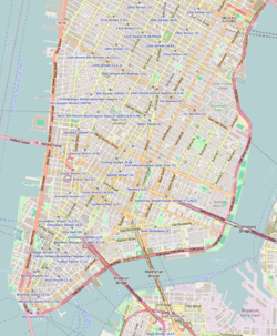
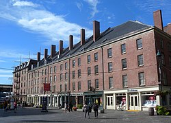
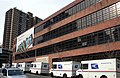
The district features some of the oldest buildings in Lower Manhattan, and includes the largest concentration of restored early 19th-century commercial buildings in the city. This includes renovated original mercantile buildings, renovated sailing ships, the former Fulton Fish Market, and modern tourist malls featuring food, shopping, and nightlife.
History
As port
The first pier in the area appeared in 1625, when the Dutch West India Company founded an outpost there.[2] With the influx of the first settlers, the area was quickly developed. One of the first and busiest streets in the area was today's Pearl Street, so named for a variety of coastal pearl shells.[3] Due to its location, Pearl Street quickly gained popularity among traders.[4][5] The East River was eventually narrowed. By the second half of the 17th century, the pier was extended to Water Street, then to Front Street, and by the beginning of the 19th century, to South Street.[2] The pier was well reputed, as it was protected from the westerly winds and ice of the Hudson River.[3]
In 1728, the Schermerhorn Family established trade with the city of Charleston, South Carolina. Subsequently, rice and indigo came from Charleston.[6] At the time, the port was also the focal point of delivery of goods from England. In 1776, during the American Revolutionary War, the British occupied the port, adversely affecting port trade for eight years. In 1783, many traders returned to England, and most port enterprises collapsed.[2] The port quickly recovered from the post-war crisis. From 1797 until the middle of 19th century, New York had the country's largest system of maritime trade.[2] From 1815 to 1860 the port was called the Port of New York.
On February 22, 1784, the Empress of China sailed from the port to Guangzhou and returned to Philadelphia on May 15, 1785,[7] bringing along, in its cargo, green and black teas, porcelain, and other goods.[8] This operation marked the beginning of trade relations between the newly formed United States and the Qing Empire.[9]
On January 5, 1818, the 424-ton transatlantic packet James Monroe sailed from Liverpool, opening the first regular trans-Atlantic voyage route, the Black Ball Line.[10] Shipping on this route continued until 1878.[11] Commercially successful transatlantic traffic has led to the creation of many competing companies, including the Red Star Line in 1822.[12][13] Transportation significantly contributed to the establishment New York as one of the centers of world trade.[2]
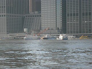
The Fish Market during the Great DepressionThe port in the late 1970s
One of the largest companies in the South Street Seaport area was the Fulton Fish Market, opened in 1822. The Tin Building opened within the market in 1907; it is one of two remaining structures from the market and the only one that is officially designated as a landmark.[14] In 2005, the market moved to Hunts Point, Bronx.[15][16]
In November 1825, the Erie Canal, located upstate, was opened.[17] The canal, connecting New York to the western United States, facilitated the economic development of the city.[18][19] However, for this reason, along with the beginning of the shipping era, there was a need to lengthen the piers and deepen the port.[20]
On the night of December 17, 1835, a large fire in New York City destroyed 17 blocks,[21] and many buildings in the South Street Seaport burned to the ground. Nevertheless, by the 1840s, the port recovered, and by 1850, it reached its heyday:[2]
Looking east, was seen in the distance on the long river front from Coenties Slip to Catharine Street [sic], innumerable masts of the many Californian clippers and London and Liverpool packets, with their long bowsprits extending way over South Street, reaching nearly to the opposite side.[22]
At its peak, the port hosted many commercial enterprises, institutions, ship-chandlers, workshops, boarding houses, saloons, and brothels. However, by the 1880s, the port began to be depleted of resources, space for the development of these businesses was diminishing, and the port became too shallow for newer ships. By the 1930s, most of the piers no longer functioned, and cargo ships docked mainly on ports on the West Side and in Hoboken.[3] By the late 1950s, the old Ward Line docks, comprising Piers 15, 16, and part of 17, were mostly vacant.[citation needed]
As museum
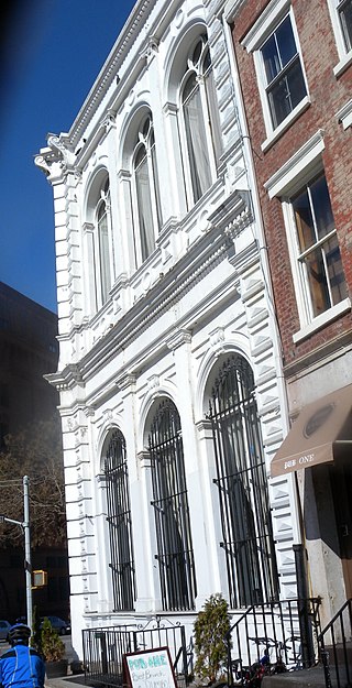
Part of Schermerhorn Row, early 19th-century mercantile buildingsWednesday Night Skate NYC stopping by Pier 16 in front of Wavertree
The South Street Seaport Museum was founded in 1967 by Peter and Norma Stanford. When originally opened as a museum, the focus of the Seaport Museum conservation was to be an educational historic site, with shops mostly operating as reproductions of working environments found during the Seaport's heyday.
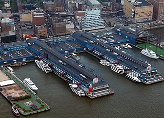
In 1982, redevelopment began to turn the museum into a greater tourist attraction via development of modern shopping areas. According to Kenneth Schuman, New York City Commissioner for Economic Development, “It would allow New Yorkers to rediscover the long-obliterated, but historic, link between the city and its waterfront.” [23] The project was undertaken by the prominent developer James Rouse, and was modeled on the concept of a "festival marketplace," a leading revitalization strategy throughout the 1970s.[24] On the other side of Fulton Street from Schermerhorn Row, the main Fulton Fish Market building, which had become a large plain garage-type structure, was rebuilt as an upscale shopping mall. Pier 17's old platforms were demolished and a new glass shopping pavilion raised in its place, which opened in August 1984.
In 1982, the Museum acquired a collection of 285 Van Ryper ship models and archival materials from Charles King Van Riper's son, Anthony K. Van Riper. The collection comprised models crafted between approximately 1938 and 1950, known as "pattern models." The archival materials encompassed research content about steamships, photographs, deck plans, postcards, and advertising brochures from steamship companies.[25]
The original intent of the Seaport development was the preservation of the block of buildings known as Schermerhorn Row on the southwest side of Fulton Street, which were threatened with neglect or future development, at a time when the history of New York City's sailing ship industry was not valued, except by some antiquarians. Early historic preservation efforts focused on these buildings and the acquisition of several sailing ships. Almost all buildings and the entire Seaport neighborhood are meant to transport the visitor back in time to New York's mid-19th century, to demonstrate what life in the commercial maritime trade was like. Docked at the Seaport are a few historical sailing vessels, including the Wavertree. A section of nearby Fulton Street is preserved as cobblestone and lined with shops, bars, and restaurants. The Bridge Cafe, which claims to be "The Oldest Drinking Establishment in New York" is in a building that formerly housed a brothel.
Pier 17 before demolition
Newly renovated Pier 17 in 2018
In late October 2012, Hurricane Sandy heavily damaged the Seaport. Tidal floods of up to 7 feet (2.1m) deep inundated much of the Seaport, causing extensive damage that forced an end to plans to merge the Seaport Museum with the Museum of the City of New York.[26] Many of the businesses closed, and the remaining businesses suffered from a severe drop in business after the storm.[27] The South Street Seaport Museum re-opened in December 2012. The Howard Hughes Corporation, announced that it would tear down the Seaport's most prominent shopping area, Pier 17, as part of a broader redevelopment of the neighborhood. The new pier contains restaurants on its ground floor, and the Rooftop at Pier 17, an outdoor concert venue five-stories above the East River.[28][29] It reopened in July 2018.[30][31] Subsequently, the Tin Building was raised and relocated 32 feet (9.8m) east in a project that started in 2018, with an expected completion date of 2021.[14]
Constituent parts
Ownership and management of Pier 17
Pier 17 is currently owned and managed by Howard Hughes Corporation.[32] Formerly, it was run by General Growth Properties, which acquired Pier 17's longtime owner, The Rouse Company, in 2004.[33] As part of its restructuring, General Growth spun off the Howard Hughes Corporation.[34]
Peck Slip
PS 343, the Peck Slip School
Peck Slip, which occupies the area between present-day Water and South streets, served as an active docking place for boats until 1810, and even served as a temporary hideout for George Washington and his troops in April 1776 when they fled from the Battle of Long Island. Then, in 1838, the first steam-powered vessel to make a transatlantic voyage, the S.S. Great Western, docked in Peck’s Slip to the cheers of a quickly growing crowd of onlookers.[35] Today, the median of the street serves as an open space for the community with Brooklyn Bridge views, often displaying public art installations and gatherings, such as fairs and concerts.[36] Peck Slip is also home to the neighborhood's K-5 elementary school The Peck Slip School, P.S. 343.[37] In 2018, plans were revealed for the redevelopment of the parking lot at 250 Water Street, across from the school.[38][39]
Museum
Designated by Congress in 1998 as one of several museums which together make up "America's National Maritime Museum", South Street Seaport Museum sits in a 12 square-block historic district that is the site of the original port of New York City.[40] The Museum has over 30,000 square feet (2,800m2) of exhibition space and educational facilities. It houses exhibition galleries, a working 19th-century print shop, an archeology museum, a maritime library, a craft center, a marine life conservation lab, and the largest privately owned fleet of historic ships in the country.
Ships in the port
The museum has five vessels docked permanently or semi-permanently, four of which have formal historical status.
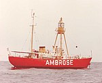
LV-87 is a lightship 135 feet (41m) long and 29 feet (8.8m) wide, built in Camden, New Jersey, in 1907. It was stationed at the entrance to Ambrose Channel and became the third lightship there since 1854. In 1932 the ship was replaced by the new LV-111 ship and moved to the Scotland Station. LV-87 was retired in 1966 and sent to the South Street Seaport in 1968. In 1989 it gained National Historic Landmark status.
The fishing schooner was launched in Essex, Massachusetts. The vessel is 125 feet (38m) long overall and 21 feet (6.4m) wide. The schooner was used for fishing mostly off the coast of Yucatan. In 1989 it was given National Historic Landmark status.
The schooner was launched in Marcus Hook, Pennsylvania. Initially, it was rigged as a sloop, but in 1895 it was rerigged as a schooner. The vessel is 102 feet (31m) long. Its hull was originally wrought iron but was rebuilt in steel in the 1960s. It was used for transportation of various goods: sand, wood, stone, bricks and oyster shells. Now it is used for educational tours of New York Harbor.
The 52 foot (16m) steam tug was built in Long Island City, Queens and first named Russell I. Subsequently, the engine was replaced by a 175 horsepower (130kW)diesel engine. In 1986 the boat was transferred to the South Street Seaport museum. In 1996 it was entered in the National Register of Historic Places.
The ship was launched in Southampton. It is 325 feet (99m) long including spars and 263 feet (80m) on deck. The ship is the largest remaining wrought iron vessel. Initially it was used for transporting jute from east India to Scotland, and then was involved in the tramp trade. In 1947 it was converted into a sand barge, and in 1968 it was acquired by the South Street Seaport Museum. In 1978 the ship was entered in the National Register of Historic Places.
The Pioneer and W. O. Decker operate during favorable weather.
Entertainment
Pier 17 was reconstructed in the 2010s and reopened in June 2018.[60] Decks outside on pier 15[61] allow views of the East River, Brooklyn Bridge, and Brooklyn Heights. The Paris Cafe, within the South Street Seaport historic area, is claimed to be one of the oldest bars in New York City.[62]
Pier 17 consists of different restaurants on its ground floor, and The Rooftop at Pier 17 on the top floor, a 3,500-capacity open-air concert venue that hosts summer concerts between May and October.[63]
Fulton Street was used in scenes from the movie Hitch (2005), starring Will Smith.[72]
The seaport is a crucial location in the film I Am Legend (2007), in which Will Smith's character broadcasts that he will be there each day at noon, to meet any fellow survivors of a virus outbreak.[73]
Many areas of the surrounding neighborhood was also used as a location in the film The Adjustment Bureau (2011)
Games
In the video game Crysis 2 (2011), Pier 17 is featured as a multi-player map.[74]
South Street Seaport makes an appearance in Grand Theft Auto IV renamed Fishmarket South.
Music
The original Sub Pop version of Nirvana's "In Bloom" video was filmed here in 1990. The video features Kurt, Krist, and Chad clowning around inside the South Street Mall as well as on Wall Street.
The Kojak episode, "Sister Maria" (1977), was filmed in the Seaport.[75]
Anthony Bourdain filmed a segment for his show A Cook's Tour, episode 5: Season 2 "Elements of a Great Bar" (2003), was filmed at Jeremy's Ale House on Front Street in the South Street Seaport.[76]
Scenes from the turn of the century Cinemax television drama series The Knick has filmed scenes on historic Front Street.[77]
Gallery
Aerial view
Fulton Market
Pier 17
Corner of Front and Beekman Streets
Peck Slip US Post Office, now reused as school[78]
Chelsea is a neighborhood on the West Side of the borough of Manhattan in New York City. The area's boundaries are roughly 14th Street to the south, the Hudson River and West Street to the west, and Sixth Avenue to the east, with its northern boundary variously described as near the upper 20s or 34th Street, the next major crosstown street to the north. To the northwest of Chelsea is the neighborhood of Hell's Kitchen, as well as Hudson Yards; to the northeast are the Garment District and the remainder of Midtown South; to the east are NoMad and the Flatiron District; to the southwest is the Meatpacking District; and to the south and southeast are the West Village and the remainder of Greenwich Village. Chelsea is named after the Royal Hospital Chelsea in London, England.
North River is an alternative name for the southernmost portion of the Hudson River in the vicinity of New York City and northeastern New Jersey in the United States.
The Financial District of Lower Manhattan, also known as FiDi, is a neighborhood located on the southern tip of Manhattan in New York City. It is bounded by the West Side Highway on the west, Chambers Street and City Hall Park on the north, Brooklyn Bridge on the northeast, the East River to the southeast, and South Ferry and the Battery on the south.
Fulton Ferry is a small area adjacent to Dumbo in the New York City borough of Brooklyn. The neighborhood is named for the Fulton Ferry, a prominent ferry line that crossed the East River between Manhattan and Brooklyn, and is also the name of the ferry slip on the Brooklyn side. The neighborhood is part of Brooklyn Community District 2.
Chelsea Piers is a series of piers in Chelsea, on the West Side of Manhattan in New York City. Located to the west of the West Side Highway and Hudson River Park and to the east of the Hudson River, they were originally a passenger ship terminal in the early 1900s that was used by the RMS Lusitania and was the destination of the RMS Carpathia after rescuing the survivors of the RMS Titanic. The piers replaced a variety of run-down waterfront structures with a row of grand buildings embellished with pink granite facades.
Fulton Street is a busy street located in Lower Manhattan in New York City. Located in the Financial District, a few blocks north of Wall Street, it runs from West Street at the site of the World Trade Center to South Street, terminating in front of the South Street Seaport. The westernmost two blocks and the easternmost block are pedestrian streets.
Hudson River Park is a waterfront park on the North River that extends from 59th Street south to Battery Park in the New York City borough of Manhattan. The park, a component of the Manhattan Waterfront Greenway, stretches 4.5 miles (7.2 km) and comprises 550 acres (220 ha), making it the second-largest park in Manhattan after the 843-acre (341 ha) Central Park.
South Street is a street in Lower Manhattan, New York City, located immediately adjacent to the East River. It runs from Whitehall Street near the southern tip of Manhattan to Jackson Street near the Williamsburg Bridge. An elevated portion of FDR Drive, known as the South Street Viaduct, runs along the entire length of the street.
Brooklyn Bridge Park is an 85-acre (34 ha) park on the Brooklyn side of the East River in New York City. Designed by landscape architecture firm Michael Van Valkenburgh Associates, the park is located on a 1.3-mile (2.1 km) plot of land from Atlantic Avenue in the south, under the Brooklyn Heights Promenade and past the Brooklyn Bridge, to Jay Street north of the Manhattan Bridge. From north to south, the park includes the preexisting Empire–Fulton Ferry and Main Street Parks; the historic Fulton Ferry Landing; and Piers 1–6, which contain various playgrounds and residential developments. The park also includes Empire Stores and the Tobacco Warehouse, two 19th-century structures, and is a part of the Brooklyn Waterfront Greenway, a series of parks and bike paths around Brooklyn.
The Peck Slip Ferry was a pre-Brooklyn Bridge ferry route connecting Manhattan and Williamsburg, Brooklyn, New York City, United States, joining Peck Slip (Manhattan) and Broadway (Brooklyn) across the East River.
The Titanic Memorial is a 60-foot-tall (18 m) lighthouse at Fulton and Pearl Streets in the Financial District of Lower Manhattan in New York City. It was built, in part at the instigation of Margaret Brown, to remember the people who died on the RMS Titanic on April 15, 1912. Its design incorporates the use of a time ball.
Transportation in New York City has ranged from strong Dutch authority in the 17th century, expansionism during the industrial era in the 19th century and half of the 20th century, to cronyism during the Robert Moses era. The shape of New York City's transportation system changed as the city did, and the result is an expansive modern-day system of industrial-era infrastructure. New York City, being the most populous city in the United States, has a transportation system which includes one of the largest subway systems in the world; the world's first mechanically ventilated vehicular tunnel; and an aerial tramway.
Front Street is a street on the southeastern side of Lower Manhattan, New York City, running southwest from Dover Street near the Brooklyn Bridge through South Street Seaport to Fulton Street in the Financial District.
The West Midtown Ferry Terminal is a passenger bus and ferry terminal serving ferries along the Hudson River in New York City and northeastern New Jersey. It is located at Pier 79 in Hudson River Park adjacent to the West Side Highway at West 39th Street in Midtown Manhattan. The facility first opened in 1986 with the start of NY Waterway commuter ferry service.
The East River Greenway is an approximately 9.44-mile-long (15.19 km) foreshoreway for walking or cycling on the east side of the island of Manhattan on the East River. It is part of the Manhattan Waterfront Greenway. The largest portions are operated by the New York City Department of Parks and Recreation. It is separated from motor traffic, and many sections also separate pedestrians from cyclists. The greenway is parallel to the Franklin D. Roosevelt East River Drive for a majority of its length.
Pier 11/Wall Street is a pier providing slips to ferries and excursion boats on the East River in the Port of New York and New Jersey. It is located east of South Street and FDR Drive just south of Wall Street in Lower Manhattan, New York City. The ferry terminal has five landings, each with two berths, and is used by four privately owned companies.
RXR Realty is a vertically integrated real estate and infrastructure owner, investor, operator, and developer headquartered in New York City. The firm’s portfolio of commercial, residential, multifamily, infrastructure, and logistics projects includes 91 commercial real estate properties and investments held across the country as of 2023. RXR is a privately held company that employs around 450 professionals with experience in operations, real estate development, construction, investment, and asset management.
John Street is a street running north to south through the Financial District of Lower Manhattan in New York City. It is one of the oldest streets in the city. Long associated with maritime activity, the street ran along Burling Slip. The slip was filled in around 1840, and the street widened. Besides a wharf, warehouse, and chandlery, the city's first permanent theatre, and the first Methodist congregation in North America were located on John Street. It was also the site of a well-known pre-Revolutionary clash between the Sons of Liberty and British soldiers, pre-dating the Boston Massacre by six weeks.
250 Water Street is a site in the Financial District of Lower Manhattan in New York City. Most recently occupied by a parking lot, the site is being developed into a mixed-use building by the Howard Hughes Corporation. The site is located in the South Street Seaport, one of the city's historic districts.
The expansion of the land area of Lower Manhattan in New York City by land reclamation has, over time, greatly altered Manhattan Island's shorelines on the Hudson and East rivers; as well as those of the Upper New York Bay. The extension of the island began with European colonialization and continued in the 20th century. Incremental encroachment as well as major infrastructure have added acreage to the island. Since the passage of the Rivers and Harbors Act of 1899 all projects which extend into navigable waterways follow federal regulation and are overseen by the United States Army Corps of Engineers.
↑ Clark, Roger. "The Rooftop at Pier 17 offers concerts with a view", NY1, June 2, 2023. Accessed January 23, 2024. "The Rooftop at Pier 17 at the Seaport in Manhattan, which started welcoming concerts and fans in 2018, offers a view of the city and music.... The rooftop is five stories above the East River, with panoramic views of the river and city landmarks like the Statue of Liberty, Empire State Building and the Brooklyn Bridge."
↑ Mondello, Bob. "I Am Legend a One-Man American Metaphor", NPR, December 14, 2017. "There's not a person in sight anywhere — except Robert Neville, who travels, when the sun is highest in the sky, to the South Street Seaport, to broadcast the same message he's been broadcasting for almost three years: 'If anyone is out there, I can provide food, shelter, security. If there's anybody out there ... you are not alone.'"
Kroessler, Jeffrey A. (2002). New York Year by Year: A Chronology of the Great Metropolis. NYU Press. ISBN0814747515.
McKay, Richard Cornelius (1969). South Street: A Maritime History of New York. Ardent Media.
Further reading
Brouwer, Norman J. South Street Seaport.
Lindgren, James Michael (2014). Preserving South Street Seaport: the dream and reality of a New York urban renewal district. New York: New York University Press. ISBN9781479822577.
This page is based on this Wikipedia article Text is available under the CC BY-SA 4.0 license; additional terms may apply. Images, videos and audio are available under their respective licenses.