
Calabarzon, sometimes referred to as Southern Tagalog and designated as Region IV‑A, is an administrative region in the Philippines. The region comprises five provinces: Batangas, Cavite, Laguna, Quezon, and Rizal; and one highly urbanized city, Lucena. It is the most populous region in the Philippines according to the Philippine Statistics Authority (PSA), having over 16.1 million inhabitants in 2020, and is also the country's second most densely populated after the National Capital Region. It is situated southeast of Metro Manila, and is bordered by Manila Bay and South China Sea to the west, Lamon Bay and the Bicol Region to the east, Tayabas Bay and the Sibuyan Sea to the south, and Central Luzon to the north. It is home to places like Mount Makiling near Los Baños, Laguna, and Taal Volcano in Batangas.

Southern Tagalog, designated as Region IV, was an administrative region in the Philippines that comprised the current regions of Calabarzon and Mimaropa, the province of Aurora of Central Luzon, and several cities of Metro Manila. The name remains as a cultural-geographical region only, which exempts Aurora.

Intramuros, is the 0.67-square-kilometer (0.26 sq mi) historic walled area within the city of Manila, the capital of the Philippines. It is administered by the Intramuros Administration with the help of the city government of Manila.

Gumaca, officially the Municipality of Gumaca, is a 1st class municipality in the province of Quezon, Philippines. According to the 2020 census, it has a population of 71,942 people.

Sariaya, officially the Municipality of Sariaya, is a 1st class municipality in the province of Quezon, Philippines. According to the 2020 census, it has a population of 161,868 people.
Banton, officially the Municipality of Banton, is a 5th class municipality in the province of Romblon, Philippines. According to the 2020 census, it has a population of 5,737 people.

Apolinario de la Cruz, better known as Hermano Pule, was a Filipino religious leader who founded and led the Cofradía de San José. The cofradía was established in 1832 in response to the racially discriminatory practices of the Catholic Church in the Philippines. During the Spanish colonial period, Catholic religious orders refused to admit native Filipinos as members. In retaliation, Pule established his own religious order that was exclusive for native Filipinos. During its peak, the cofradía had 4,500 to 5,000 members from the provinces of Tayabas, Batangas, and Laguna. Fearing an armed rebellion, the Spanish colonial government sent military forces to suppress the cofradía, an attack that was resisted by Hermano Pule and his followers on October 23, 1841. However, more troops were sent and the cofradía was finally quelled by the colonial military forces on November 1, 1841. Pule was then captured, tried, and executed.

The Bondoc Peninsula is a peninsula located in the southeastern part of Quezon Province in Calabarzon Region, southern part of Luzon, Philippines. The peninsula consists of 12 municipalities: Agdangan, Buenavista, Catanauan, General Luna, Macalelon, Mulanay, Padre Burgos, Pitogo, San Andres, San Francisco, San Narciso and Unisan, all in the 3rd Congressional District of Quezon. The peninsula is known for featuring beautiful beaches and historic churches.
The architecture of the Philippines reflects the historical and cultural traditions in the country. Most prominent historic structures in the archipelago are influenced by Austronesian, American architectures.

Quezon, officially the Province of Quezon, is a province in the Philippines located in the Calabarzon region on Luzon. Kaliraya/Kalilayan was the first known name of the province upon its creation in 1591. Around the middle of the 18th century, it was changed to Tayabas. In recognition of the second president of the Philippines, Manuel L. Quezon, the name of Tayabas Province is changed to Quezon. Lucena, the provincial capital, the seat of the provincial government, and the most populous city of the province, is governed independently from the province as a highly urbanized city. To distinguish the province from Quezon City, it is sometimes called Quezon Province, a variation of the province's official name.

The Minor Basilica of Saint Michael the Archangel (Tagalog: Basílika Menor ni San Miguel Arkanghel; Spanish: Basílica Menor de San Miguel Arcángel) commonly known as the Tayabas Basilica, is a Roman Catholic basilica located in Tayabas, Quezon, Philippines, under the Diocese of Lucena. Its titular saint is Michael the Archangel, whose feast is celebrated every September 29.

Tayabas, officially the City of Tayabas, is a 6th class component city in the province of Quezon, Philippines. According to the 2020 census, it has a population of 112,658 people.

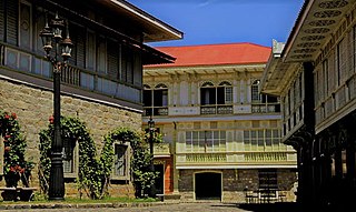
Ancestral houses of the Philippines or Heritage Houses are homes owned and preserved by the same family for several generations as part of the Filipino family culture. It corresponds to long tradition by Filipino people of giving reverence for ancestors and elders. Houses could be a simple house to a mansion. The most common ones are the "Bahay na Bato". Some houses of prominent families had become points of interest or museums in their community because of its cultural, architectural or historical significance. These houses that are deemed of significant importance to the Filipino culture are declared Heritage House by the National Historical Commission of the Philippines (NHCP), previously known as the National Historical Institute (NHI) of the Philippines. Preservation is of utmost importance as some ancestral houses have come into danger due to business people who buy old houses in the provinces, dismantle them then sell the parts as ancestral building materials for homeowners wishing to have the ancestral ambiance on their houses. These ancestral houses provide the current generation a look back of the country's colonial past through these old houses.
Santo Domingo Church, formally known as the National Shrine of Our Lady of the Holy Rosary of La Naval de Manila, is a Roman Catholic national shrine and parish church in Quezon City, Metro Manila in the Philippines. Dedicated to Mary, mother of Jesus under her title Our Lady of the Most Holy Rosary — La Naval de Manila, it was founded by the Dominicans in 1587.

The Malagonlong Bridge and is a five-span 445 ft (136 m) long stone arch bridge built during the Spanish colonial period in Tayabas, Quezon, Philippines. The bridge is known as one of the oldest bridges as well as the longest bridge made during the Spanish era. It was declared a National Cultural Treasure under the Historic Bridges of Tayabas on August 12, 2011.

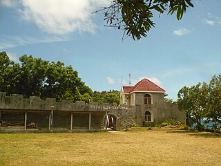
The Twin Forts of Romblon are a pair of Spanish fortifications located in the town of Romblon, Romblon in the Philippines. It was built by the Spanish in 1644 to protect the town from Muslim raids and Dutch piracy in the country during the Eighty Years' War. In 2013, the site has been declared a National Cultural Treasure under the protection of the Philippine government through the National Museum of the Philippines.

The Historic Bridges of Romblon are a group of bridges that were built during the Spanish and American colonial era over the Casalogan River in the town of Romblon, Romblon in the Philippines. In March 2013, these bridges were declared an Important Cultural Property by the Philippine government and was placed under the protection and conservation of the National Museum of the Philippines.


