Spraberry Trend

Last updated
Location of the Spraberry Trend in Texas, showing major and nearby cities. Black lines are county boundaries. Spraberry.png
Location of the Spraberry Trend in Texas, showing major and nearby cities. Black lines are county boundaries.

The Spraberry Trend (also known as the Spraberry Field, Spraberry Oil Field, and Spraberry Formation; sometimes erroneously written as Sprayberry) is a large oil field in the Permian Basin of West Texas, covering large parts of six counties, and having a total area of approximately 2,500 square miles (6,500 km2). It is named for Abner Spraberry, the Dawson County farmer who owned the land containing the 1943 discovery well. [1] The Spraberry Trend is itself part of a larger oil-producing region known as the Spraberry-Dean Play, within the Midland Basin. Discovery and development of the field began the postwar economic boom in the nearby city of Midland in the early 1950s. The oil in the Spraberry, however, proved difficult to recover. After about three years of enthusiastic drilling, during which most of the initially promising wells showed precipitous and mysterious production declines, the area was dubbed "the world's largest unrecoverable oil reserve." [2]

Contents

In 2007, the U.S. Department of Energy ranked The Spraberry Trend third in the United States by total proved reserves, and seventh in total production. Estimated reserves for the entire Spraberry-Dean unit exceeded 10 billion barrels (1.6×10⁹ m3), and by the end of 1994, the field had reported a total production of 924 million barrels (146,900,000 m3). [3] [4]

Setting

The Spraberry Trend covers a large area – around 2,500 square miles (6,500 km2) – and includes portions of two Texas geographical regions, the Llano Estacado and the Edwards Plateau. As most often defined, the Spraberry includes portions of Irion, Reagan, Upton, Glasscock, Midland, and Martin Counties, although the underlying geologic unit also touches Dawson, Crockett, and Andrews Counties. Elevations are generally between 2,500 and 3,000 feet (910 m) above sea level, and the terrain varies from flat to rolling, with occasional canyons, known locally as "draws", cutting through the plateau. Drainage is to the east, via the Concho River to the Colorado River. The climate is semi-arid. Native vegetation includes scrub and grasslands, with trees such as cottonwoods along the watercourses. [5]

Aside from activities associated with oil production, transport, and storage, predominant land use in the area includes ranching and farming.

Geology

All of the Spraberry Trend oil fields produce from a single enormous sedimentary unit known as the Spraberry Sand, which consists of complexly mixed fine sandstone and calcareous or silicate mudstone and siltstone, deposited in a deep water environment distinguished by channel systems and their associated submarine fans, all of Permian age. The sands are interbedded with shales, and typically pinch-out updip. Oil accumulated in stratigraphic traps as it migrated upward from source rocks until encountering impermeable barriers, either in the internal shaly members or the overlying impermeable formation. Unlike many of the oil-bearing rocks of West Texas, however, the very low porosity and permeability hamper economic oil recovery. The rocks are naturally fractured, further complicating hydrocarbon flow. [6] [7] [8]

Shaly rocks make up 87% of the Spraberry, with the oil-bearing sands and siltstones present sometimes in thin layers between them. The best-producing zone is at an average depth of 6,800 feet (2,100 m) across the entire region, which is about 150 miles (240 km) long by 70 wide. [9] [10] [11]

History

The first well drilled into the formation was by Seaboard Oil Company in 1943, on land owned by farmer Abner Spraberry in Dawson County. While the well bore showed an oil-bearing unit had been found, and hence received Spraberry's name, it did not produce commercial quantities of oil. That changed in 1949, when the same company drilled well Lee 2-D, which produced 319 barrels per day (50.7 m3/d) – hardly a spectacular discovery, but enough to pique the interest of numerous independent operators looking for opportunity around Midland. In 1950 and 1951, several other independent oil companies drilled productive wells separated by great distances, establishing that the formation was at least 150 miles (240 km) long, and beginning a frenzy of drilling in the region surrounding Midland. [12]

Unfortunately for most of the speculators, investors, and outside independent oil companies, most of the newly drilled wells behaved badly; they produced oil nicely for a short time, and then production fell off sharply, with wells often failing to break even. In 1950, the cost of drilling and putting down 8,000 feet (2,400 m) of steel casing required a well to produce 50,000 barrels (7,900 m3) just to break even in the face of the low federally mandated price of $2.58/barrel. Local companies that had been skeptical of the Spraberry since the beginning of the boom did not suffer the losses of the outsiders who had come in expecting to profit in the huge oil play. Even the professional geologists could not agree on what was wrong: in October, 1951, a convention in Midland of hundreds of engineers and petroleum geologists reached no consensus on the issues with the field, although the peculiar and irregularly fractured nature of the oil-bearing rocks seemed to be a large part of the problem. In May 1952, there were more than 1,630 Spraberry wells in the Midland basin, most recently drilled, but local enthusiasm had ended. [13] In the following years, each operator developed its own methods of dealing with the unusual reservoir, and began to employ a technique known as "hydrofracturing" – forcing water down wells at extreme pressure, causing the rocks to fracture further, resulting in increased oil flow. This was moderately successful, and development of the Spraberry continued, albeit with greatly diminished expectations for massive output. [14] Yet another method of fracturing the rocks to increase production was to pump a mixture of soap and kerosene, followed by a coarse-grained sand, also under intense pressure. [15]

During the initial boom period the Spraberry promoters carried out an aggressive campaign to bring in outside investment, making exorbitant claims of the potential easy profit with the vast reserves of oil. As every well drilled into the Spraberry Sands anywhere in the Midland Basin found oil, at least initially, it seemed at first that their claims were not completely without merit. Yet their tactics were not subtle: one group of promoters from Los Angeles brought in a group of Hollywood models, and had these women photographed on the drilling rigs, working the equipment in the nude. [16]

Using the normal 40-acre (160,000 m2) spacing employed elsewhere in West Texas proved impossible on the Spraberry; wells that close competed against each other, as yields per-acre from the difficult reservoir were dropping into the hundreds of barrels rather than the expected thousands. Oil companies resorted to the unusual step of asking the Railroad Commission of Texas, the regulatory body which decided on well spacing and production quota, to require 80-acre (320,000 m2), and then even 160-acre (0.65 km2) spacing to allow each drilling site to be profitable. [17] [18] Many of the initial wells were abandoned in the next few years as they ran out of oil; modern enhanced recovery techniques, such as carbon dioxide injection, were not yet available.

For a period in the 1950s the abundant natural gas in the reservoir was simply flared off – burned above the wellhead – since no recovery infrastructure existed. Steel was expensive, transport costs high, and profit margins from the field were too low to allow the development of the sort of gas pipelines that exist in most modern oil fields. Aircraft pilots reported that hundreds of square miles of west Texas were lit at night from the fires of thousands of gas flares, and the people in Midland reported seeing what appeared to be a false sunrise in the east shortly after each sunset. In 1953 the Railroad Commission prohibited the wasteful practice, shutting down all wells in the field until a recovery system could be built. After a series of lawsuits and court battles, the Railroad Commission backed down, compromising with the operators by allowing them a set number of days per month during which they could pump oil and flare gas. [19] The overall gas reserves of the field were estimated to be over two trillion cubic feet; during the peak of the early 1950s gas-flaring, over 220 million cubic feet (6,200,000 m3) per day were burned. [20] [21]

The field grew in the 1960s with the annexation of several adjacent oil pools, and overall production increased with the implementation of enhanced recovery technologies, such as waterflooding. In the 1970s, as the price of oil went up, drilling and production proceeded; while Spraberry wells were never abundant producers, during periods of high prices they could provide dependable profits for oil companies, and the local economy entered its strongest period. [22] In the 21st century, newer technologies such as carbon dioxide flooding have been used to increase production. Even with these advances, the Spraberry retains about 90% of its original calculated reserves, largely due to the difficulty of recovery. As of 2009, there were approximately 9,000 active wells in the Spraberry Trend. [23] [24]

Notes

  1. Time (magazine) 1951 Time Magazine article on the Spraberry
  2. Olien/Hinton, p. 103
  3. Top 100 Oil and Gas Fields Archived 2009-05-15 at the Wayback Machine
  4. Spraberry-Dean Sandstone Fields: Handbook of Texas Online
  5. Texas Ecological Regions
  6. Scott L. Montgomery, David S. Schechter, and John Lorenz. "Advanced Reservoir Characterization to Evaluate Carbon Dioxide Flooding, Spraberry Trend, Midland Basin, Texas." AAPG Bulletin
  7. Final Report ...
  8. Ian Lerche, Sheila North. Economics of Petroleum Production: Value and Worth. p. 85. Multi-Science Publishing Company, Ltd. 2004. ISBN   0-906522-24-2
  9. Donald Peaceman. Fundamentals of numerical reservoir simulation. Elsevier, 1977. ISBN   0-444-41625-0. p. 131.
  10. Mahlon M. Ball, Permian Basin Province. United States Geological Survey.
  11. Olien/Hinton, pp. 99-101
  12. Olien/Hinton, pp. 99-100
  13. Spraberry-Dean Sandstone Fields: Handbook of Texas Online
  14. Olien/Hinton, pp. 100-101
  15. 1951 Time Magazine article on the Spraberry
  16. Olien/Hinton, p. 101
  17. 1951 Time Magazine article on the Spraberry
  18. Olien/Hinton, p. 103-104
  19. Olien/Hinton, p. 105-7
  20. USGS, p. 14
  21. Olien/Hinton, p. 106
  22. Spraberry-Dean Sandstone Fields: Handbook of Texas Online
  23. Page on the Spraberry Trend, at Harold Vance Department of Petroleum Engineering, Texas A&M University
  24. Montgomery/Schechter/Lorenz

Related Research Articles

<span class="mw-page-title-main">History of the petroleum industry in the United States</span>

The history of the petroleum industry in the United States goes back to the early 19th century, although the indigenous peoples, like many ancient societies, have used petroleum seeps since prehistoric times; where found, these seeps signaled the growth of the industry from the earliest discoveries to the more recent.

Petroleum geology is the study of origin, occurrence, movement, accumulation, and exploration of hydrocarbon fuels. It refers to the specific set of geological disciplines that are applied to the search for hydrocarbons.

<span class="mw-page-title-main">Permian Basin (North America)</span> Large sedimentary basin in the US

The Permian Basin is a large sedimentary basin in the southwestern part of the United States. The basin contains the Mid-continent oil field province. This sedimentary basin is located in western Texas and southeastern New Mexico. It reaches from just south of Lubbock, past Midland and Odessa, south nearly to the Rio Grande River in southern West Central Texas, and extending westward into the southeastern part of New Mexico. It is so named because it has one of the world's thickest deposits of rocks from the Permian geologic period. The greater Permian Basin comprises several component basins; of these, the Midland Basin is the largest, Delaware Basin is the second largest, and Marfa Basin is the smallest. The Permian Basin covers more than 86,000 square miles (220,000 km2), and extends across an area approximately 250 miles (400 km) wide and 300 miles (480 km) long.

<span class="mw-page-title-main">North Sea oil</span> Hydrocarbons from the North Sea

North Sea oil is a mixture of hydrocarbons, comprising liquid petroleum and natural gas, produced from petroleum reservoirs beneath the North Sea.

The Tangguh gas field is a gas field lies in Berau Gulf and Bintuni Bay, in the province of West Papua, Indonesia. The natural gas field contains over 500 billion cubic metres of proven natural gas reserves, with estimates of potential reserves reaching over 800 billion cubic metres.

<span class="mw-page-title-main">Petroleum reservoir</span> Subsurface pool of hydrocarbons

A petroleum reservoir or oil and gas reservoir is a subsurface accumulation of hydrocarbons contained in porous or fractured rock formations.

<span class="mw-page-title-main">East Texas Oil Field</span> Oil and gas field in east Texas

The East Texas Oil Field is a large oil and gas field in east Texas. Covering 140,000 acres (57,000 ha) and parts of five counties, and having 30,340 historic and active oil wells, it is the second-largest oil field in the United States outside Alaska, and first in total volume of oil recovered since its discovery in 1930. Over 5.42 billion barrels (862,000,000 m3) of oil have been produced from it to-date. It is a component of the Mid-continent oil province, the huge region of petroleum deposits extending from Kansas to New Mexico to the Gulf of Mexico.

<span class="mw-page-title-main">San Juan Basin</span>

The San Juan Basin is a geologic structural basin located near the Four Corners region of the Southwestern United States. The basin covers 7,500 square miles and resides in northwestern New Mexico, southwestern Colorado, and parts of Utah and Arizona. Specifically, the basin occupies space in the San Juan, Rio Arriba, Sandoval, and McKinley counties in New Mexico, and La Plata and Archuleta counties in Colorado. The basin extends roughly 100 miles (160 km) N-S and 90 miles (140 km) E-W.

<span class="mw-page-title-main">Sirte Basin</span>

The Sirte Basin is a late Mesozoic and Cenozoic triple junction continental rift along northern Africa that was initiated during the late Jurassic Period. It borders a relatively stable Paleozoic craton and cratonic sag basins along its southern margins. The province extends offshore into the Mediterranean Sea, with the northern boundary drawn at the 2,000 meter (m) bathymetric contour. It borders in the north on the Gulf of Sidra and extends south into northern Chad.

The Sarir Field was discovered in southern Cyrenaica during 1961 and is considered to be the largest oil field in Libya, with estimated oil reserves of 12 Gbbl (1.9 km3). Sarir is operated by the Arabian Gulf Oil Company (AGOCO), a subsidiary of the state-owned National Oil Corporation (NOC).

<span class="mw-page-title-main">Bakken Formation</span> Geological rock formation known for crude oil production

The Bakken Formation is a rock unit from the Late Devonian to Early Mississippian age occupying about 200,000 square miles (520,000 km2) of the subsurface of the Williston Basin, underlying parts of Montana, North Dakota, Saskatchewan and Manitoba. The formation was initially described by geologist J. W. Nordquist in 1953. The formation is entirely in the subsurface, and has no surface outcrop. It is named after Henry O. Bakken (1901–1982), a farmer in Tioga, North Dakota, who owned the land where the formation was initially discovered while drilling for oil.

<span class="mw-page-title-main">Bend Arch–Fort Worth Basin</span>

The Bend Arch–Fort Worth Basin Province is a major petroleum producing geological system which is primarily located in North Central Texas and southwestern Oklahoma. It is officially designated by the United States Geological Survey (USGS) as Province 045 and classified as the Barnett-Paleozoic Total Petroleum System (TPS).

<span class="mw-page-title-main">Yates Oil Field</span>

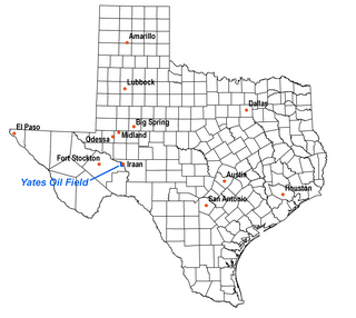
The Yates Oil Field is a giant oil field in the Permian Basin of west Texas. Primarily in extreme southeastern Pecos County, it also stretches under the Pecos River and partially into Crockett County. Iraan, on the Pecos River and directly adjacent to the field, is the nearest town. The field has produced more than one billion barrels of oil, making it one of the largest in the United States, and in 1998 it remains productive, though at a diminished rate. Since fracking has exploded in the Permian Basin, the Yates field has seen very heavy activity in the past three years. Estimated recoverable reserves are still approximately one billion barrels, which represents approximately 50% of the original oil in place (OOIP).

<span class="mw-page-title-main">Tight oil</span> Light crude oil in petroleum-bearing formations

Tight oil is light crude oil contained in unconventional petroleum-bearing formations of low permeability, often shale or tight sandstone. Economic production from tight oil formations requires the same hydraulic fracturing and often uses the same horizontal well technology used in the production of shale gas. While sometimes called "shale oil", tight oil should not be confused with oil shale or shale oil. Therefore, the International Energy Agency recommends using the term "light tight oil" for oil produced from shales or other very low permeability formations, while the World Energy Resources 2013 report by the World Energy Council uses the terms "tight oil" and "shale-hosted oil".

<span class="mw-page-title-main">Cat Canyon Oil Field</span>

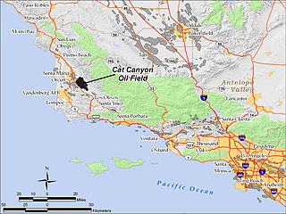
The Cat Canyon Oil Field is a large oil field in the Solomon Hills of central Santa Barbara County, California, about 10 miles southeast of Santa Maria. It is the largest oil field in Santa Barbara County, and as of 2010 is the 20th-largest in California by cumulative production.

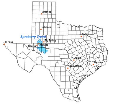
As of 2013 the Cline Shale, also referred to as the "Wolfcamp/Cline Shale", the "Lower Wolfcamp Shale", or the "Spraberry-Wolfcamp shale", or even the "Wolfberry", is a promising Pennsylvanian oil play east of Midland, Texas which underlies ten counties: Fisher, Nolan, Sterling, Coke, Glasscock, Tom Green, Howard, Mitchell, Borden and Scurry counties. Exploitation is projected to rely on hydraulic fracturing.

an organic rich shale, with Total Organic Content (TOC) of 1-8%, with silt and sand beds mixed in. It lies in a broad shelf, with minimal relief and has nice light oil of 38-42 gravity with excellent porosity of 6-12% in thickness varying 200 to 550 feet thick.

<span class="mw-page-title-main">Wattenberg Gas Field</span>

The Wattenberg Gas Field is a large producing area of natural gas and condensate in the Denver Basin of central Colorado, USA. Discovered in 1970, the field was one of the first places where massive hydraulic fracturing was performed routinely and successfully on thousands of wells. The field now covers more than 2,000 square miles between the cities of Denver and Greeley, and includes more than 23,000 wells producing from a number of Cretaceous formations. The bulk of the field is in Weld County, but it extends into Adams, Boulder, Broomfield, Denver, and Larimer Counties.

<span class="mw-page-title-main">Eagle Ford Group</span> Texas rock formation associated with petroleum deposits

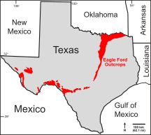
The Eagle Ford Group is a sedimentary rock formation deposited during the Cenomanian and Turonian ages of the Late Cretaceous over much of the modern-day state of Texas. The Eagle Ford is predominantly composed of organic matter-rich fossiliferous marine shales and marls with interbedded thin limestones. It derives its name from outcrops on the banks of the West Fork of the Trinity River near the old community of Eagle Ford, which is now a neighborhood within the city of Dallas. The Eagle Ford outcrop belt trends from the Oklahoma-Texas border southward to San Antonio, westward to the Rio Grande, Big Bend National Park, and the Quitman Mountains of West Texas. It also occurs in the subsurface of East Texas and South Texas, where it is the source rock for oil found in the Woodbine, Austin Chalk, and the Buda Limestone, and is produced unconventionally in South Texas and the "Eaglebine" play of East Texas. The Eagle Ford was one of the most actively drilled targets for unconventional oil and gas in the United States in 2010, but its output had dropped sharply by 2015. By the summer of 2016, Eagle Ford spending had dropped by two-thirds from $30 billion in 2014 to $10 billion, according to an analysis from the research firm Wood Mackenzie. This strike has been the hardest hit of any oil fields in the world. The spending was, however, expected to increase to $11.6 billion in 2017. A full recovery is not expected any time soon.

<span class="mw-page-title-main">West Siberian petroleum basin</span> Petroleum and natural gas basin in Russia

The West Siberian petroleum basin is the largest hydrocarbon basin in the world covering an area of about 2.2 million km², and is also the largest oil and gas producing region in Russia.

<span class="mw-page-title-main">Carabobo Field</span>

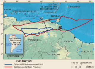
Carabobo is an oil field located in Venezuela's Orinoco Belt. As one of the world's largest accumulations of recoverable oil, the recent discoveries in the Orinoco Belt have led to Venezuela holding the world's largest recoverable reserves in the world, surpassing Saudi Arabia in July 2010. The Carabobo oil field is majority owned by Venezuela's national oil company, Petroleos de Venezuela SA (PDVSA). Owning the majority of the Orinoco Belt, and its estimated 1.18 trillion barrels of oil in place, PDVSA is now the fourth largest oil company in the world. The field is well known for its extra Heavy crude oils, having an average specific gravity between 4 and 16 °API. The Orinoco Belt holds 90% of the world's extra heavy crude oils, estimated at 256 billion recoverable barrels. While production is in its early development, the Carabobo field is expected to produce 400,000 barrels of oil per day.

References

Coordinates: 31°44′30″N101°52′28″W / 31.7416°N 101.8744°W / 31.7416; -101.8744