St Budeaux

Last updated

St Budeaux
St Paul's RC Church, St Budeaux - geograph.org.uk - 718044.jpg
St Paul's Catholic Church
Devon UK location map.svg
Red pog.svg
St Budeaux
Location within Devon
Population13,369 (2011) [1]
OS grid reference SX4458
Unitary authority
Ceremonial county
Region
Country England
Sovereign state United Kingdom
Post town PLYMOUTH
Postcode district PL5
Dialling code 01752
Police Devon and Cornwall
Fire Devon and Somerset
Ambulance South Western
UK Parliament
List of places
UK
England
Devon
50°24′12″N4°11′08″W / 50.403333°N 4.185556°W / 50.403333; -4.185556

St Budeaux is an area and ward in the north west of Plymouth in the English county of Devon.

Contents

Original settlement

The name St Budeaux comes from Saint Budoc, the Bishop of Dol (Brittany). Around 480, Budoc is said to have founded a settlement and built a small church. The church eventually gave way to a permanent stone one, dedicated to Saint Budoc, which was erected shortly before the Norman conquest of England.

The village is documented in William the Conqueror's Domesday Book of 1086. Known as Bucheside, it was valued at 30 shillings (around six times the amount of neighbouring manors). Over the course of the next few hundred years, Bucheside became Bodekishide, Budeokshed, and even Bottockishide and Butshead, the latter form being recorded on the Trevill monuments in the church. [2] The modern name, St Budeaux, is itself a Frenchified "elegant" form.

15th to 18th centuries

The Parish Church of St Budeaux St Budeaux Church and yard.jpg
The Parish Church of St Budeaux

St Budeaux became a separate parish in 1482 by the decision of the Bishop of Exeter. During the early Tudor period, demand grew for a larger church, which was completed in 1563. The church was described in 1804 as "a simple edifice, and, though devoid of architectural embellishment, possesses much picturesque beauty."

1518

Francis Drake was given his coat of arms for his support toward the country. with the words written on his coat of arms. (SIC PARVIS MAGNA)

On 4 July 1569, Sir Francis Drake married local woman Mary Newman (Lady Drake was buried there in 1582).

During the Civil War, Plymouth and its surrounding villages (including St Budeaux) swore an oath to die for the Parliamentarian cause. They were besieged by the Royalist Cornwall just across the water, which took control of St Budeaux and used the church as a garrison. The church was virtually destroyed by the war's end and was not restored until 1655.

19th century

In 1805, a Gunpowder Works was established alongside Kinterbury Creek for the purpose of restoring damp or damaged gunpowder offloaded from ships. This hazardous process involved unpacking the powder from its barrels, assessing and sieving it, and then "restoving" it (i.e. drying the damp powder in specialized ovens) after which it would be stored in a magazine once more ready for use. [3] At the time the main magazine lcomplex for Plymouth was at Keyham, but when land there was required for development of the Dockyard a new location was needed; so in 1852, the Board of Ordnance opened a new depot alongside the Works at St Budeaux; named Bull Point, it could accommodate up to 40,000 barrels of powder. [4] RNAD Bull Point closed in 2009 but remains in MoD ownership; the site includes some 48 listed buildings. [5]

In 1860, the War Department purchased a sizable amount of land in the area due to Prime Minister Lord Palmerston's fear of the French, then ruled by Napoleon III. His fear was exaggerated, and the line of military forts encircling Plymouth later became known as "Palmerston's Follies." However, the upheaval contributed to an increase in the local population and a subsequent change in the area's character. Agaton Fort (see below) was only 480 yards (440 m) to the north of St Budeaux and was completed in 1871.

In 1890 the first railway station master was commissioned his name was Edmund Tolley. He was a well respected member of the community and well known to the locals.

In the 1890s, the parish became a self-contained village with significant development in Lower St Budeaux. Much of the development was incited by General John Trelawney, formerly John Jago, who inherited a great deal of St Budeaux's land from his uncle in 1883. In 1890, the village was already growing due to the construction of the Royal Albert Bridge and the improvement of area roads, as well as a new London and South Western Railway station, St Budeaux Victoria Road. There was also a Great Western Railway station at Ferry Road. In the following decade, Trelawney built houses and roads and sold to Joseph Stribling the land that would become the Trelawny Hotel in 1895. The hotel included two bars, a bar parlour, a club room, a coach house, outbuildings, stables and yards, and was the first building in St Budeaux to be lit by electricity. Many new shops also opened in the area during the same time period.

In 1899, St Budeaux merged with the town of Devonport, resulting in many improvements to local roads and communications availability. Improvements included the construction of a new railway bridge enabling the Devonport and District Tramway Company to provide efficient service from Devonport, through St Budeaux, to Saltash Passage, linking Plymouth to Cornwall.

20th century

In 1918, following World War I, St Budeaux and the other towns and villages in the treatment were amalgamated into the city of Plymouth. Amid the heavy demolition and construction of this period, six more churches were built in the parish. Much of this activity was initiated by the Plymouth Corporation, which made a habit of buying up the estates of principal landowners and destroying them in order to develop new amenities on the land. The vicar of St Budeaux church at the time, the Reverend T. A. Hancock, was appalled by the corporation's actions and protested in the 1930s, but to no avail.

Many homes in the region were bombed during World War II, and subsequent rebuilding resulted in a rapid housing explosion.

Tamarside Community College Tamarside Community College - geograph.org.uk - 719201.jpg
Tamarside Community College

Modern St Budeaux

Today, St Budeaux includes a Catholic church, a Methodist church, a Baptist church and two Church of England churches. It also has a public library, three pubs, four primary schools (including St Budeaux Church of England Primary Academy) and two railway stations (St Budeaux Ferry Road and St Budeaux Victoria Road), although the village does not have its own secondary school. Most of the main shops including a KFC outlet, are situated in St Budeaux Square which is adjacent to Wolseley Road. Most children of secondary school age in the area attend Marine Academy Plymouth in the nearby ward of King's Tamerton or bus to one of the residual grammar schools or one of the many other community colleges.

The western wall of Agaton Fort Wall of Agaton Fort, Plymouth. - geograph.org.uk - 915280.jpg
The western wall of Agaton Fort

Agaton Fort

Plan of Agaton Fort Agaton Fort from Admiralty Chart No 871 Tamar River, Published 1966.jpg
Plan of Agaton Fort

Part of the north-eastern defences of Plymouth, work on Agaton Fort started in 1863 on a hill near the hamlet of Agaton, in the parish of St Budeaux. It is a five-sided polygonal fort, and was designed to mount fifteen 7-inch guns which could mutually support the neighbouring Ernesettle Fort and Knowle Battery. The initial contractor failed in 1866 and the work was completed in 1871 by Royal Engineers. Only three of the 7-inch guns were ever mounted, along with five 64-pounder guns for close defence. It was also protected by a dry ditch and three caponiers. The fort was disarmed in the 1890s, but continued in military use through both World Wars. [6] It is now a VOSA Test Station and is a Scheduled monument. [7]

On 27 March 2020, it was announced that Agaton Fort would become a temporary mortuary facility, in response to the 2019-20 coronavirus pandemic. [8] [9]

Historic estates

Related Research Articles

<span class="mw-page-title-main">Yelverton, Devon</span> Village in Devon, England

Yelverton is a large village on the south-western edge of Dartmoor, Devon, in England. It is in the civil parish of Buckland Monachorum.

Crownhill is an area of northern Plymouth, in the county of Devon, England.

<span class="mw-page-title-main">Upnor</span> Villages in Kent, England

Lower Upnor and Upper Upnor are two small villages in Medway, Kent, England. They are in the parish of Frindsbury Extra on the western bank of the River Medway. Today the two villages are mainly residential and a centre for small craft moored on the river, but Upnor Castle is a preserved monument, part of the river defences from the sixteenth century.

<span class="mw-page-title-main">Plymouth Devonport (UK Parliament constituency)</span> Former UK Parliament constituency

Plymouth, Devonport was, from 1832 until 2010, a borough constituency represented in the House of Commons of the Parliament of the United Kingdom. It covered part of the city of Plymouth in South West England, including the former borough of Devonport.

<span class="mw-page-title-main">Tamar Valley Line</span> Railway line in Devon and Cornwall, England

The Tamar Valley Line is a railway line from Plymouth, Devon, to Gunnislake, Cornwall, in England, also known as the Gunnislake branch line. The line follows the River Tamar for much of its route. Like all railway lines in Devon and Cornwall, it is unelectrified and all trains are diesel powered. The entire line is single track past St. Budeaux Junction.

<span class="mw-page-title-main">Plymouth, Devonport and South Western Junction Railway</span> Former English railway company

The Plymouth, Devonport and South Western Junction Railway (PD&SWJR) was an English railway company. It constructed a main line railway between Lydford and Devonport, in Devon, England, enabling the London and South Western Railway (LSWR) to reach Plymouth more conveniently than before.

<span class="mw-page-title-main">St Budeaux Victoria Road railway station</span> Railway station in Devon, England

St Budeaux Victoria Road railway station is a suburban station in St Budeaux, Plymouth, Devon, England. The station is managed and served by Great Western Railway.

Weston Mill is a district in the ward of Ham, which is part of the City of Plymouth, Devon, England. It consists of two parts Weston Mill Village which was first mentioned in the Domesday Book in 1155 and the other part which dates to the Victorian period, they are separated by Weston Mill Hill, which is the only street with this name. It shares its borders with Ham Woods Nature Reserve, King's Tamerton, St. Budeaux and Camels Head. The area derived its name from being the mill belonging to the tithing, Geoffrey de Weston. It is situated close to the major naval base Devonport Dockyard, and the majority of the housing in the area is privately owned. The A3064 'St. Budeaux Bypass' also runs through the area. Together with King's Tamerton the area's population in the 2001 census, was 4,647, of which 50.2 per cent were male and 49.8 per cent were female.

<span class="mw-page-title-main">HMNB Devonport</span> Operating base in the United Kingdom for the Royal Navy

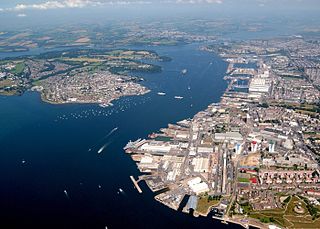
His Majesty's Naval Base, Devonport is one of three operating bases in the United Kingdom for the Royal Navy and is the sole nuclear repair and refuelling facility for the Royal Navy. The largest naval base in Western Europe, HMNB Devonport is located in Devonport, in the west of the city of Plymouth, England.

<span class="mw-page-title-main">Exeter to Plymouth railway of the LSWR</span>

The Exeter to Plymouth railway of the London and South Western Railway (LSWR) was the westernmost part of a route competing with that of the Great Western Railway (GWR) and its 'associated companies' from London and Exeter to Plymouth in Devon, England. Whereas the GWR route from Exeter followed the coast to Newton Abbot and then went around the southern edge of Dartmoor, the LSWR route followed the northern and western margins of Dartmoor, passing through the towns of Crediton, Okehampton, and Tavistock.

<span class="mw-page-title-main">Gunpowder magazine</span> Building used to store gunpowder

A gunpowder magazine is a magazine (building) designed to store the explosive gunpowder in wooden barrels for safety. Gunpowder, until superseded, was a universal explosive used in the military and for civil engineering: both applications required storage magazines. Most magazines were purely functional and tended to be in remote and secure locations. They are the successor to the earlier powder towers and powder houses.

Ernesettle is mentioned in the Domesday Book, which documented land in England and Wales, and describes as an ‘old Saxon manor’ there. By the 15th century, there were two farms, Great Ernesettle and Little Ernesettle, both named after William Ernstell, a freeholder of Budshead, who owned land here in 1428. By the 16th century, Ernesettle was a thriving hamlet, and Budshead Mill and a manor house were built on the bank of the river Their date of construction is uncertain, but in 1780 the owner was recorded as Sir Harry Trelawney and the tenant was Mr Robert Nicholls.

<span class="mw-page-title-main">Railways in Plymouth</span> Overview of railways in Plymouth, Devon, England

The network of railways in Plymouth, Devon, England, was developed by companies affiliated to two competing railways, the Great Western Railway and the London and South Western Railway. At their height two main lines and three branch lines served 28 stations in the Plymouth area, but today just six stations remain in use.

<span class="mw-page-title-main">Devonport Kings Road railway station</span> Disused railway station in Devon, England

Devonport Kings Road railway station was the London and South Western Railway station in Devonport, Devon, England. It opened in 1876 and closed in 1964. For the first 14 years it was a terminal station with trains to London departing eastwards, but from 1890 it became a through station with trains to London departing westwards.

<span class="mw-page-title-main">History of Plymouth</span> History of the city in Devon, England

The History of Plymouth in Devon, England, extends back to the Bronze Age, when the first settlement began at Mount Batten a peninsula in Plymouth Sound facing onto the English Channel. It continued as both a fishing and continental tin trading port through the late Iron Age into the Early Medieval period, until the more prosperous Saxon settlement of Sutton, later renamed Plymouth, surpassed it. With its natural harbour and open access to the Atlantic, the town found wealth and a national strategic importance during the establishment of British naval dominance in the colonisation of the New World. In 1620 the Pilgrim Fathers departed from Plymouth to establish the second English colony in America. During the English Civil War the town was besieged between 1642 and 1646 by the Royalists, but after the Restoration a Dockyard was established in the nearby town of Devonport. Throughout the Industrial Revolution Plymouth grew as a major mercantile shipping industry, including imports and passengers from the US, whilst Devonport grew as a naval base and ship construction town, building battleships for the Royal Navy – which later led to its partial destruction during World War II in a series of air-raids known as the Plymouth Blitz. After the war was over, the city centre was completely rebuilt to a new plan.

<span class="mw-page-title-main">Tramways in Plymouth</span> Tramways in Plymouth, Devon, England

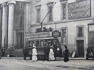
The tramways in Plymouth were originally constructed as four independent networks operated by three different companies to serve the adjacent towns of Plymouth, Stonehouse and Devonport in Devon, England. The merger of the 'Three Towns' into the new borough of Plymouth in 1914 was the catalyst for the three companies to join up under the auspices of the new Plymouth Corporation. The network was closed in 1945, partly as a result of bomb damage during World War II.

The following is a timeline of the history of the city of Plymouth, Devon, England.

<span class="mw-page-title-main">Fortifications of Plymouth</span>

The fortifications of Plymouth in Devon are extensive due to its natural harbour, its commanding position on the Western Approaches and its role as the United Kingdom's largest naval base. The first medieval defences were built to defend Sutton Harbour on the eastern side of Plymouth Sound at the mouth of the River Plym, but by the 18th century, naval activity had begun to shift westward to Devonport at the mouth of the River Tamar. During the Victorian era, advances in military technology led to a huge programme of fortification encompassing the whole of Plymouth Sound together with the overland approaches. Many of these works remained in military use well into the 20th century.

Weston Mill Halt railway station was named after a mill and quay with its lime kiln sitting on Weston Mill Lake next to the River Tamar. The small settlement of Weston Mill also lay near by and the halt was opened as part of Plymouth's suburban network development, together with other halts such as the nearby Camels Head Halt, by the London and South Western Railway in 1906, closing in 1921 or Sunday 4 May 1942. It was located on the outskirts of the city not far from the Great Western Railway main line's Weston Mill Bridge.

<span class="mw-page-title-main">Ford (Devon) railway station</span> Former railway station in England

Ford (Devon) railway station was originally named Ford railway station and stood at the eastern end of Station Road, Keyham Barton in Plymouth, South Devon.

References

  1. "Plymouth ward 2011" . Retrieved 5 April 2015.
  2. Rogers, William Henry Hamilton, The Strife of the Roses and Days of the Tudors in the West, Exeter, 1890
  3. Cocroft, Wayne (1999). Dangerous Energy: the archaeology of gunpowder and military explosives manufacture. Swindon: English Heritage. pp. 58–59.
  4. English Heritage National Survey of Ordnance Yards and Magazine Depots
  5. "West Briton". Archived from the original on 28 September 2015.
  6. Victorian Forts: Agaton Fort Factsheet
  7. English Heritage National Monuments Record: Agaton Fort
  8. "Setting up temporary mortuary facility | PLYMOUTH.GOV.UK". plymouth.gov.uk. Retrieved 27 March 2020.
  9. Oldfield, Edward (27 March 2020). "Temporary mortuary being built in Plymouth". plymouthherald. Retrieved 27 March 2020.