
In aviation, instrument flight rules (IFR) is one of two sets of regulations governing all aspects of civil aviation aircraft operations; the other is visual flight rules (VFR).
In aviation, visual flight rules (VFR) are a set of regulations under which a pilot operates an aircraft in weather conditions generally clear enough to allow the pilot to see where the aircraft is going. Specifically, the weather must be better than basic VFR weather minima, i.e., in visual meteorological conditions (VMC), as specified in the rules of the relevant aviation authority. The pilot must be able to operate the aircraft with visual reference to the ground, and by visually avoiding obstructions and other aircraft.

Air traffic control (ATC) is a service provided by ground-based air traffic controllers who direct aircraft on the ground and through a given section of controlled airspace, and can provide advisory services to aircraft in non-controlled airspace. The primary purpose of ATC worldwide is to prevent collisions, organize and expedite the flow of air traffic, and provide information and other support for pilots.
The basic principles of air navigation are identical to general navigation, which includes the process of planning, recording, and controlling the movement of a craft from one place to another.
Airspace is the portion of the atmosphere controlled by a country above its territory, including its territorial waters or, more generally, any specific three-dimensional portion of the atmosphere. It is not the same as outer space which is the expanse or space outside the Earth and aerospace which is the general term for Earth's atmosphere and the outer space within the planet's vicinity.
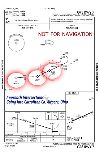
In aviation, an intersection is a virtual navigational fix that helps aircraft maintain their flight plan. It is usually defined as the intersection of two VOR radials. They are usually identified as major airway intersections where aircraft, operating under instrument flight rules, often change direction of flight while en route. According to the Federal Aviation Regulations, some intersections are designated as mandatory reporting points for pilots who are not in radar contact with air traffic control.
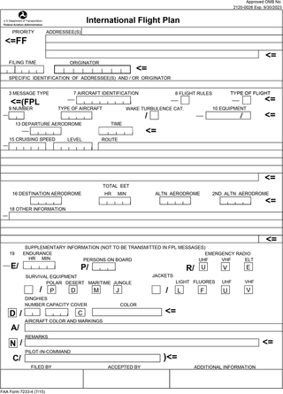
Flight plans are documents filed by a pilot or flight dispatcher with the local Air Navigation Service Provider prior to departure which indicate the plane's planned route or flight path. Flight plan format is specified in ICAO Doc 4444. They generally include basic information such as departure and arrival points, estimated time en route, alternate airports in case of bad weather, type of flight, the pilot's information, number of people on board, and information about the aircraft itself. In most countries, flight plans are required for flights under IFR, but may be optional for flying VFR unless crossing international borders. Flight plans are highly recommended, especially when flying over inhospitable areas such as water, as they provide a way of alerting rescuers if the flight is overdue. In the United States and Canada, when an aircraft is crossing the Air Defense Identification Zone (ADIZ), either an IFR or a special type of VFR flight plan called a DVFR flight plan must be filed. For IFR flights, flight plans are used by air traffic control to initiate tracking and routing services. For VFR flights, their only purpose is to provide needed information should search and rescue operations be required, or for use by air traffic control when flying in a "Special Flight Rules Area."
An instrument rating is an authorization required for a pilot to fly under instrument flight rules (IFR). In the United States, the rating is issued by the Federal Aviation Administration.

In aviation, an instrument approach or instrument approach procedure (IAP) is a series of predetermined maneuvers for the orderly transfer of an aircraft operating under instrument flight rules from the beginning of the initial approach to a landing, or to a point from which a landing may be made visually. These approaches are approved in the European Union by EASA and the respective country authorities and in the United States by the FAA or the United States Department of Defense for the military. The ICAO defines an instrument approach as "a series of predetermined maneuvers by reference to flight instruments with specific protection from obstacles from the initial approach fix, or where applicable, from the beginning of a defined arrival route to a point from which a landing can be completed and thereafter, if landing is not completed, to a position at which holding or en route obstacle clearance criteria apply."

In aviation, holding is a maneuver designed to delay an aircraft already in flight while keeping it within a specified airspace; i.e. "going in circles."
An aeronautical chart is a map designed to assist in the navigation of aircraft, much as nautical charts do for watercraft, or a roadmap does for drivers. Using these charts and other tools, pilots are able to determine their position, safe altitude, best route to a destination, navigation aids along the way, alternative landing areas in case of an in-flight emergency, and other useful information such as radio frequencies and airspace boundaries. There are charts for all land masses on Earth, and long-distance charts for trans-oceanic travel.
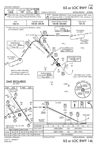
Approach plates are the printed or digital charts of instrument approach procedures that pilots use to fly instrument approaches during instrument flight rules (IFR) operations. Each country maintains its own instrument approach procedures according to International Civil Aviation Organization (ICAO) standards.
Standard instrument departure (SID) routes, also known as departure procedures (DP), are published flight procedures followed by aircraft on an IFR flight plan immediately after takeoff from an airport.
The Capstone Program was a United States government-funded aviation safety program for the state of Alaska, primarily focusing on rural areas of the state. This joint effort – between the Federal Aviation Administration (FAA), the Alaska Pilot's Association, commercial operators, the University of Alaska, MITRE Corporation, some avionics manufacturers and individual pilots – cut the accident rate in the eastern part of Alaska by around 40%.
The Next Generation Air Transportation System (NextGen) is an ongoing United States Federal Aviation Administration (FAA) project to modernize the National Airspace System (NAS). The FAA began work on NextGen improvements in 2007 and plans to finish the final implementation segment by 2030. The goals of the modernization include using new technologies and procedures to increase the safety, efficiency, capacity, access, flexibility, predictability, and resilience of the NAS while reducing the environmental impact of aviation.
The National Airspace System (NAS) is the airspace, navigation facilities and airports of the United States along with their associated information, services, rules, regulations, policies, procedures, personnel and equipment. It includes components shared jointly with the military. It is one of the most complex aviation systems in the world, and services air travel in the United States and over large portions of the world's oceans.

In aviation, a visual approach is an approach to a runway at an airport conducted under instrument flight rules (IFR) but where the pilot proceeds by visual reference and clear of clouds to the airport. The pilot must at all times have either the airport or the preceding aircraft in sight. This approach must be authorized and under the control of the appropriate air traffic control (ATC) facility. The International Civil Aviation Organization (ICAO) definition adds that the visual approach can commence when "either part or all of an instrument approach is not completed", varying only slightly from the Federal Aviation Administration regulation and is essentially identical.
A contact approach is an approach available to aircraft operating on an instrument flight rules (IFR) flight plan, where the pilot may deviate from the published instrument approach procedure (IAP) and proceed to the destination airport by visual reference to the surface. It is similar to a visual approach, except that the pilot is not required to have the destination airport nor the preceding aircraft in sight at all times during the approach, and the visibility requirements are less stringent.
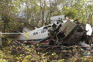
On 12 September 2012 at about 12:20 local time, Petropavlovsk-Kamchatsky Air Flight 251, operated by an Antonov An-28, crashed while attempting to land at Palana Airport in Russia. Both pilots were killed, together with 8 of the 12 passengers. All 4 survivors were in serious condition. The aircraft descended below minima on approach in instrument meteorological conditions and impacted a forested slope. Alcohol was found in the blood of both flight crew.
ForeFlight is an electronic flight bag for iOS and iPadOS devices designed to assist pilots and corporate flight departments with flight planning. It includes information about facilities such as airports, NAVAIDs, and air traffic control facilities. It also aids pilots in tasks including flight planning, weather monitoring, and document management, as well as an electronic logbook to help pilots record flight time. The United States, Canada, and Europe are supported regions. The company was founded in 2007 and has since been purchased by Boeing.