Instrument flight rules

Last updated

IFR in between cloud layers in a Cessna 172 IFR in IMC over SLI into LGB on the VOR and ILS in a 172 photo D Ramey Logan.jpg
IFR in between cloud layers in a Cessna 172

In aviation, instrument flight rules (IFR) is one of two sets of regulations governing all aspects of civil aviation aircraft operations; the other is visual flight rules (VFR).

Contents

The U.S. Federal Aviation Administration's (FAA) Instrument Flying Handbook defines IFR as: "Rules and regulations established by the FAA to govern flight under conditions in which flight by outside visual reference is not safe. IFR flight depends upon flying by reference to instruments in the flight deck, and navigation is accomplished by reference to electronic signals." [1] It is also a term used by pilots and controllers to indicate the type of flight plan an aircraft is flying, such as an IFR or VFR flight plan. [2]

Basic information

Comparison to visual flight rules

It is possible and fairly straightforward, in relatively clear weather conditions, to fly an aircraft solely by reference to outside visual cues, such as the horizon to maintain orientation, nearby buildings and terrain features for navigation, and other aircraft to maintain separation. This is known as operating the aircraft under visual flight rules (VFR), and is the most common mode of operation for small aircraft. However, it is safe to fly VFR only when these outside references can be clearly seen from a sufficient distance. When flying through or above clouds, or in fog, rain, dust or similar low-level weather conditions, these references can be obscured. Thus, cloud ceiling and flight visibility are the most important variables for safe operations during all phases of flight. [3] The minimum weather conditions for ceiling and visibility for VFR flights are defined in FAR Part 91.155, and vary depending on the type of airspace in which the aircraft is operating, and on whether the flight is conducted during daytime or nighttime. However, typical daytime VFR minimums for most airspace is 3 statute miles of flight visibility and a distance from clouds of 500 feet below, 1,000 feet above, and 2,000 feet horizontally. [4] Flight conditions reported as equal to or greater than these VFR minimums are referred to as visual meteorological conditions (VMC).

Any aircraft operating under VFR must have the required equipment on board, as described in FAR Part 91.205 [5] (which includes some instruments necessary for IFR flight). VFR pilots may use cockpit instruments as secondary aids to navigation and orientation, but are not required to; the view outside of the aircraft is the primary source for keeping the aircraft straight and level (orientation), flying to the intended destination (navigation), and avoiding obstacles and hazards (separation). [6]

Visual flight rules are generally simpler than instrument flight rules, and require significantly less training and practice. VFR provides a great degree of freedom, allowing pilots to go where they want, when they want, and allows them a much wider latitude in determining how they get there. [7]

Instrument flight rules

When operation of an aircraft under VFR is not safe, because the visual cues outside the aircraft are obscured by weather, instrument flight rules must be used instead. IFR permits an aircraft to operate in instrument meteorological conditions (IMC), which is essentially any weather condition less than VMC but in which aircraft can still operate safely. Use of instrument flight rules is also required when flying in "Class A" airspace regardless of weather conditions. Class A airspace extends from 18,000 feet above mean sea level to flight level 600 (60,000 feet pressure altitude) above the contiguous 48 United States and overlying the waters within 12 miles thereof. [8] Flight in Class A airspace requires pilots and aircraft to be instrument equipped and rated and to be operating under instrument flight rules (IFR). In many countries commercial airliners and their pilots must operate under IFR as the majority of flights enter Class A airspace. [9] Procedures and training are significantly more complex compared to VFR instruction, as a pilot must demonstrate competency in conducting an entire cross-country flight solely by reference to instruments.

Instrument pilots must carefully evaluate weather, create a detailed flight plan based around specific instrument departure, en route, and arrival procedures, and dispatch the flight. [6] [10]

Separation and clearance

The distance by which an aircraft avoids obstacles or other aircraft is termed separation. The most important concept of IFR flying is that separation is maintained regardless of weather conditions. In controlled airspace, air traffic control (ATC) separates IFR aircraft from obstacles and other aircraft using a flight clearance based on route, time, distance, speed, and altitude. ATC monitors IFR flights on radar, or through aircraft position reports in areas where radar coverage is not available. Aircraft position reports are sent as voice radio transmissions. In the United States, a flight operating under IFR is required to provide position reports unless ATC advises a pilot that the plane is in radar contact. The pilot must resume position reports after ATC advises that radar contact has been lost, or that radar services are terminated.

IFR flights in controlled airspace require an ATC clearance for each part of the flight. A clearance always specifies a clearance limit, which is the farthest the aircraft can fly without a new clearance. In addition, a clearance typically provides a heading or route to follow, altitude, and communication parameters, such as frequencies and transponder codes.

In uncontrolled airspace, ATC clearances are unavailable. In some states a form of separation is provided to certain aircraft in uncontrolled airspace as far as is practical (often known under ICAO as an advisory service in class G airspace), but separation is not mandated nor widely provided.

Despite the protection offered by flight in controlled airspace under IFR, the ultimate responsibility for the safety of the aircraft rests with the pilot in command, who can refuse clearances.

Weather

IFR flying with clouds below IFR on top.jpg
IFR flying with clouds below

It is essential to differentiate between flight plan type (VFR or IFR) and weather conditions (VMC or IMC). While current and forecast weather may be a factor in deciding which type of flight plan to file, weather conditions themselves do not affect one's filed flight plan. For example, an IFR flight that encounters visual meteorological conditions (VMC) en route does not automatically change to a VFR flight, and the flight must still follow all IFR procedures regardless of weather conditions. In the US, weather conditions are forecast broadly as VFR, MVFR (marginal visual flight rules), IFR, or LIFR (low instrument flight rules). [11]

The main purpose of IFR is the safe operation of aircraft in instrument meteorological conditions (IMC). The weather is considered to be MVFR or IMC when it does not meet the minimum requirements for visual meteorological conditions (VMC). To operate safely in IMC ("actual instrument conditions"), a pilot controls the aircraft relying on flight instruments and ATC provides separation. [12]

It is important not to confuse IFR with IMC. A significant amount of IFR flying is conducted in visual meteorological conditions (VMC). Anytime a flight is operating in VMC and in a volume of airspace in which VFR traffic can operate, the crew is responsible for seeing and avoiding VFR traffic; however, because the flight is conducted under instrument flight rules, ATC still provides separation services from other IFR traffic, and can in many cases also advise the crew of the location of VFR traffic near the flight path.[ citation needed ]

Although dangerous and illegal, a certain amount of VFR flying is conducted in IMC. A scenario is a VFR pilot taking off in VMC conditions, but encountering deteriorating visibility while en route. Continued VFR flight into IMC can lead to spatial disorientation of the pilot which is the cause of a significant number of general aviation crashes. VFR flight into IMC is distinct from "VFR-on-top", an IFR procedure in which the aircraft operates in VMC using a hybrid of VFR and IFR rules, and "VFR over the top", a VFR procedure in which the aircraft takes off and lands in VMC but flies above an intervening area of IMC. Also possible in many countries is "Special VFR" flight, where an aircraft is explicitly granted permission to operate VFR within the controlled airspace of an airport in conditions technically less than VMC; the pilot asserts they have the necessary visibility to fly despite the weather, must stay in contact with ATC, and cannot leave controlled airspace while still below VMC minimums.[ citation needed ]

During flight under IFR, there are no visibility requirements, so flying through clouds (or other conditions where there is zero visibility outside the aircraft) is legal and safe. However, there are still minimum weather conditions that must be present in order for the aircraft to take off or to land; these vary according to the kind of operation, the type of navigation aids available, the location and height of terrain and obstructions in the vicinity of the airport, equipment on the aircraft, and the qualifications of the crew. For example, Reno-Tahoe International Airport (KRNO) in a mountainous region has significantly different instrument approaches for aircraft landing on the same runway surface, but from opposite directions. Aircraft approaching from the north must make visual contact with the airport at a higher altitude than when approaching from the south because of rapidly rising terrain south of the airport. [13] This higher altitude allows a flight crew to clear the obstacle if a landing is aborted. In general, each specific instrument approach specifies the minimum weather conditions to permit landing.

Although large airliners, and increasingly, smaller aircraft, carry their own terrain awareness and warning system (TAWS), [14] these are primarily backup systems providing a last layer of defense if a sequence of errors or omissions causes a dangerous situation. [14]

Because IFR flights often take place without visual reference to the ground, a means of navigation other than looking outside the window is required. A number of navigational aids are available to pilots, including ground-based systems such as DME/VORs and NDBs as well as the satellite-based GPS/GNSS system. Air traffic control may assist in navigation by assigning pilots specific headings ("radar vectors"). The majority of IFR navigation is given by ground- and satellite-based systems, while radar vectors are usually reserved by ATC for sequencing aircraft for a busy approach or transitioning aircraft from takeoff to cruise, among other things.[ citation needed ]

Procedures

Specific procedures allow IFR aircraft to transition safely through every stage of flight. These procedures specify how an IFR pilot should respond, even in the event of a complete radio failure, and loss of communications with ATC, including the expected aircraft course and altitude.[ citation needed ]

Departures are described in an IFR clearance issued by ATC prior to takeoff. The departure clearance may contain an assigned heading, one or more waypoints, and an initial altitude to fly. The clearance can also specify a departure procedure (DP) or standard instrument departure (SID) that should be followed unless "NO DP" is specified in the notes section of the filed flight plan.[ citation needed ]

En route flight is described by IFR charts showing navigation aids, fixes, and standard routes called airways . Aircraft with appropriate navigational equipment such as GPS, are also often cleared for a direct-to routing, where only the destination, or a few navigational waypoints are used to describe the route that the flight will follow. ATC will assign altitudes in its initial clearance or amendments thereto, and navigational charts indicate minimum safe altitudes for airways.[ citation needed ]

The approach portion of an IFR flight may begin with a standard terminal arrival route (STAR), describing common routes to fly to arrive at an initial approach fix (IAF) from which an instrument approach commences. An instrument approach terminates either by the pilot acquiring sufficient visual reference to proceed to the runway, or with a missed approach because the required visual reference is not seen in time.[ citation needed ]

Qualifications

Pilot

To fly under IFR, a pilot must have an instrument rating and must be current (meet recency of experience requirements). In the United States, to file and fly under IFR, a pilot must be instrument-rated and, within the preceding six months, have flown six instrument approaches, as well as holding procedures and course interception and tracking with navaids. Flight under IFR beyond six months after meeting these requirements is not permitted; however, currency may be reestablished within the next six months by completing the requirements above. Beyond the twelfth month, examination ("instrument proficiency check") by an instructor is required. [15]

Practicing instrument approaches can be done either in the instrument meteorological conditions or in visual meteorological conditions – in the latter case, a safety pilot is required so that the pilot practicing instrument approaches can wear a view-limiting device which restricts his field of view to the instrument panel. A safety pilot's primary duty is to observe and avoid other traffic.[ citation needed ]

In the UK, an IR (UK restricted) - formerly the "IMC rating" - which permits flight under IFR in airspace classes B to G in instrument meteorological conditions, a non-instrument-rated pilot can also elect to fly under IFR in visual meteorological conditions outside controlled airspace. Compared to the rest of the world, the UK's flight crew licensing regime is somewhat unusual in its licensing for meteorological conditions and airspace, rather than flight rules.[ citation needed ]

Aircraft

The aircraft must be equipped and type-certified for instrument flight, and the related navigational equipment must have been inspected or tested within a specific period of time prior to the instrument flight.

In the United States, instruments required for IFR flight in addition to those that are required for VFR flight are: heading indicator, sensitive altimeter adjustable for barometric pressure, clock with a sweep-second pointer or digital equivalent, attitude indicator, radios and suitable avionics for the route to be flown, alternator or generator, gyroscopic rate-of-turn indicator that is either a turn coordinator or the turn and bank indicator. [16] From 1999 single-engine helicopters could not be FAA-certified for IFR. [17] Recently, however, Bell and Leonardo have certified the single engine helicopters for instrument flight rules.[ citation needed ]

See also

Related Research Articles

In aviation, visual flight rules (VFR) are a set of regulations under which a pilot operates an aircraft in weather conditions generally clear enough to allow the pilot to see where the aircraft is going. Specifically, the weather must be better than basic VFR weather minima, i.e., in visual meteorological conditions (VMC), as specified in the rules of the relevant aviation authority. The pilot must be able to operate the aircraft with visual reference to the ground, and by visually avoiding obstructions and other aircraft.

<span class="mw-page-title-main">Air traffic control</span> Public service provided for the purpose of maintaining the safe and orderly flow of air traffic

Air traffic control (ATC) is a service provided by ground-based air traffic controllers who direct aircraft on the ground and through a given section of controlled airspace, and can provide advisory services to aircraft in non-controlled airspace. The primary purpose of ATC worldwide is to prevent collisions, organize and expedite the flow of air traffic, and provide information and other support for pilots.

The basic principles of air navigation are identical to general navigation, which includes the process of planning, recording, and controlling the movement of a craft from one place to another.

Airspace is the portion of the atmosphere controlled by a country above its territory, including its territorial waters or, more generally, any specific three-dimensional portion of the atmosphere. It is not the same as outer space which is the expanse or space outside the Earth and aerospace which is the general term for Earth's atmosphere and the outer space within the planet's vicinity. History:

<span class="mw-page-title-main">Visual meteorological conditions</span> Flight category allowing pilots to fly using vision as well as instruments

In aviation, visual meteorological conditions (VMC) is an aviation flight category in which visual flight rules (VFR) flight is permitted—that is, conditions in which pilots have sufficient visibility to fly the aircraft maintaining visual separation from terrain and other aircraft. They are the opposite of instrument meteorological conditions (IMC). The boundary criteria between IMC and VMC are known as the VMC minima and are defined by: visibility, cloud ceilings, and cloud clearances.

Instrument rating refers to the qualifications that a pilot must have in order to fly under instrument flight rules (IFR). It requires specific training and instruction beyond what is required for a private pilot certificate or commercial pilot certificate, including rules and procedures specific to instrument flying, additional instruction in meteorology, and more intensive training in flight solely by reference to instruments.

In aviation, lowest safe altitude (LSALT) is an altitude that is at least 500 feet above any obstacle or terrain within a defined safety buffer region around a particular route that a pilot might fly. The safety buffer allows for errors in the air by including an additional area that a pilot might stray into by flying off track. By flying at or above this altitude a pilot complies with terrain clearance requirements on that particular flight leg.

<span class="mw-page-title-main">Flight plan</span> Document filed by a pilot or flight dispatcher indicating the aircrafts flight path

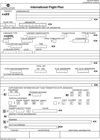
Flight plans are documents filed by a pilot or flight dispatcher with the local Air Navigation Service Provider prior to departure which indicate the plane's planned route or flight path. Flight plan format is specified in ICAO Doc 4444. They generally include basic information such as departure and arrival points, estimated time en route, alternate airports in case of bad weather, type of flight, the pilot's information, number of people on board, and information about the aircraft itself. In most countries, flight plans are required for flights under IFR, but may be optional for flying VFR unless crossing international borders. Flight plans are highly recommended, especially when flying over inhospitable areas such as water, as they provide a way of alerting rescuers if the flight is overdue. In the United States and Canada, when an aircraft is crossing the Air Defense Identification Zone (ADIZ), either an IFR or a special type of VFR flight plan called a DVFR flight plan must be filed. For IFR flights, flight plans are used by air traffic control to initiate tracking and routing services. For VFR flights, their only purpose is to provide needed information should search and rescue operations be required, or for use by air traffic control when flying in a "Special Flight Rules Area."

In general aviation, scud running is a practice in which pilots lower their altitude to avoid clouds or instrument meteorological conditions (IMC). The goal of scud running is to stay clear of weather to continue flying with visual, rather than instrument, references. This practice is widely accepted to be dangerous, and has led to death in many cases from pilots flying into terrain or obstacles, such as masts and towers, normally referred to as controlled flight into terrain, or CFIT; however, even instrument-rated pilots sometimes elect to take the risk to avoid icing or embedded thunderstorms in cloud, or in situations where the minimum instrument altitudes are too high for their aircraft.

The world's navigable airspace is divided into three-dimensional segments, each of which is assigned to a specific class. Most nations adhere to the classification specified by the International Civil Aviation Organization (ICAO) and described below, though they might use only some of the classes defined below, and significantly alter the exact rules and requirements. Similarly, individual nations may also designate special use airspace (SUA) with further rules for reasons of national security or safety.

<span class="mw-page-title-main">Instrument meteorological conditions</span> Flight category requiring pilots to fly with instruments rather than sight

In aviation, instrument meteorological conditions (IMC) are weather conditions that require pilots to fly primarily by reference to flight instruments, and therefore under instrument flight rules (IFR), as opposed to flying by outside visual references under visual flight rules (VFR). Typically, this means flying in cloud or poor weather, where little or nothing can be seen or recognised when looking out of the window. Simulated IMC can be achieved for training purposes by wearing view-limiting devices, which restrict outside vision and force the trainee to rely on instrument indications only.

An instrument rating is an authorization required for a pilot to fly under instrument flight rules (IFR). In the United States, the rating is issued by the Federal Aviation Administration.

<span class="mw-page-title-main">Instrument approach</span> Aircraft landing procedure

In aviation, an instrument approach or instrument approach procedure (IAP) is a series of predetermined maneuvers for the orderly transfer of an aircraft operating under instrument flight rules from the beginning of the initial approach to a landing, or to a point from which a landing may be made visually. These approaches are approved in the European Union by EASA and the respective country authorities and in the United States by the FAA or the United States Department of Defense for the military. The ICAO defines an instrument approach as "a series of predetermined maneuvers by reference to flight instruments with specific protection from obstacles from the initial approach fix, or where applicable, from the beginning of a defined arrival route to a point from which a landing can be completed and thereafter, if landing is not completed, to a position at which holding or en route obstacle clearance criteria apply."

Special visual flight rules are a set of aviation regulations under which a pilot may operate an aircraft. It is a special case of operating under visual flight rules (VFR).

<span class="mw-page-title-main">Allegheny Airlines Flight 853</span> 1969 mid-air collision

Allegheny Airlines Flight 853 was a regularly scheduled Allegheny Airlines flight from Boston, Massachusetts, to St. Louis, Missouri, with stops in Baltimore, Maryland, Cincinnati, Ohio, and Indianapolis, Indiana. On September 9, 1969, the aircraft serving the flight, a McDonnell Douglas DC-9, collided in mid-air with a Piper PA-28 light aircraft near Fairland, Indiana. The DC-9 was carrying 78 passengers and 4 crew members, and the Piper was leased to a student pilot on a solo cross-country flight. All 83 occupants of both aircraft were killed in the accident and both aircraft were destroyed.

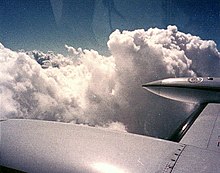
VFR over-the-top (OTT) refers to flying over top of clouds in visual flight, rather than with reference to instruments. This is usually done for brief amount of time to avoid weather or turbulence.

An aeronautical chart is a map designed to assist in the navigation of aircraft, much as nautical charts do for watercraft, or a roadmap does for drivers. Using these charts and other tools, pilots are able to determine their position, safe altitude, best route to a destination, navigation aids along the way, alternative landing areas in case of an in-flight emergency, and other useful information such as radio frequencies and airspace boundaries. There are charts for all land masses on Earth, and long-distance charts for trans-oceanic travel.

<span class="mw-page-title-main">Airspace class (United States)</span> U.S. airspace system classification scheme

The United States airspace system's classification scheme is intended to maximize pilot flexibility within acceptable levels of risk appropriate to the type of operation and traffic density within that class of airspace – in particular to provide separation and active control in areas of dense or high-speed flight operations.

In United States aviation VFR-on-top is defined as air traffic control authorization for an aircraft operating under instrument flight rules (IFR) to do so in visual meteorological conditions (VMC) at any appropriate visual flight rules (VFR) altitude. A pilot receiving this authorization must comply with the VFR visibility, distance from cloud criteria, and the minimum IFR altitudes. The use of this term does not relieve controllers of their responsibility to separate aircraft in Class B and Class C airspace or TRSAs.

A contact approach is an approach available to aircraft operating on an instrument flight rules (IFR) flight plan, where the pilot may deviate from the published instrument approach procedure (IAP) and proceed to the destination airport by visual reference to the surface. It is similar to a visual approach, except that the pilot is not required to have the destination airport nor the preceding aircraft in sight at all times during the approach, and the visibility requirements are less stringent.

References

  1. "Instrument Flying Handbook" (PDF), Instrument Flight Rules (defined), Oklahoma City, Oklahoma: Federal Aviation Administration, 2008, pp. G–9
  2. "Aeronautical Information Manual" (PDF), Instrument Flight Rules (defined), Oklahoma City, Oklahoma: Federal Aviation Administration, 11 February 2010, pp. PCG I−4
  3. Keel, Byron; Stancil, Charles; Eckert, Clifford; Brown, Susan (June 2000). "Aviation Weather Information Requirements Recommendations". Aviation Weather Information Requirements Study. Hampton, Virginia: NASA Langley Research Center. pp. 40–41. CiteSeerX   10.1.1.32.1842 .{{cite book}}: |work= ignored (help)
  4. "14 CFR 91.155 [ Basic VFR weather minimums ]" (PDF). Federal Aviation Regulations: 721–722. 11 February 2010. Retrieved 27 November 2010.
  5. "FAR Part 91 Sec. 91.205 effective as of 10/20/2009". rgl.faa.gov. Retrieved 31 March 2018.
  6. 1 2 Collins, Richard (11 November 2006). "Getting an Instrument Rating". Flying . 133 (11): 68. Retrieved 27 November 2010.
  7. Wallace, Lane (3 May 2010). "The Basics: VFR Flight Planning". Flying . 137 (4): 61. Retrieved 27 November 2010.
  8. "FAR Part 71 Sec. 71.33" . Retrieved 24 August 2015.
  9. Federal Aviation Regulations Title 14, Chapter I, Subchapter E, §71.31, §71.33
  10. Goyer, Robert (30 April 2010). "IFR Flight Prep: A Whole New Game". Flying . 137 (4): 56. Retrieved 27 November 2010.
  11. Aviation Weather Center - METARs Help Page (4 of 5) National Weather Center. Retrieved 29 January 2015
  12. McCloy, John. "Safety Pilot in IMC". IFR magazine. Archived from the original on 5 September 2007. Retrieved 20 May 2009.
  13. See KRNO approach plates for "LOC RWY 16R", "ILS RWY 16R", and "ILS or LOC/DME RWY 34L".
  14. 1 2 "Terrain Awareness and Warning Systems—TAWS". Skybrary. Retrieved 11 July 2014
  15. US Code of Federal Regulations, 14 CFR 61.57(c) and (d)
  16. "14 CFR 91.205" (PDF). gpo.gov. Retrieved 31 March 2018.
  17. Hirschberg, Mike (April–May 2015). "Resurrecting single-engine helicopter IFR". Vertical Magazine. Archived from the original on 19 April 2015. Retrieved 11 April 2015.
Listen to this article (20 minutes)
Sound-icon.svg
This audio file was created from a revision of this article dated 9 December 2017 (2017-12-09), and does not reflect subsequent edits.