
The Limpopo River rises in South Africa and flows generally eastward through Mozambique to the Indian Ocean. The term Limpopo is derived from Rivombo (Livombo/Lebombo), a group of Tsonga settlers led by Hosi Rivombo who settled in the mountainous vicinity and named the area after their leader. The river has been called Vhembe by local Venda communities of the area where now that name has been adopted by the South African government as its District Municipality in the north, a name that was also suggested in 2002 as a possible name to be adopted for the Province but was voted against. The river is approximately 1,750 kilometres (1,087 mi) long, with a drainage basin 415,000 square kilometres (160,200 sq mi) in size. The mean discharge measured over a year is 170 m3 per second at its mouth. The Limpopo is the second largest river in Africa that drains to the Indian Ocean, after the Zambezi River.

Gaza is a province of Mozambique. It has an area of 75,709 km2 and a population of 1,422,460, which is the least populous of all the provinces of Mozambique.

The Olifants River,Lepelle, iBhalule or Obalule is a river in South Africa and Mozambique, a tributary of the Limpopo River. It falls into the Drainage Area B of the Drainage basins of South Africa. The historical area of the Pedi people, Sekhukhuneland, is located between the Olifants River and one of its largest tributaries, the Steelpoort River.

The Mokolo River is a major watercourse in Limpopo Province of South Africa. This river collects much of the drainage of the Waterberg Massif and discharges it to the Limpopo River. The river's catchment area comprises 8,387 square kilometres (3,238 sq mi).
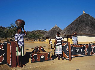
The Pedi or Bapedi, also known as the Sotho, Basotho, Northern Sotho, Basotho ba Lebowa, Transvaal Sotho, Marota, or Bamaroteng are a Sotho-Tswana ethnic group that speak Pedi or Sepedi, which is one of the 12 official languages in South Africa. They are primarily situated in Limpopo, Gauteng and northern Mpumalanga.
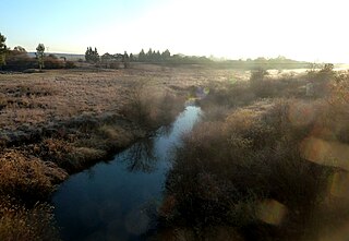
The Sand River or Polokwane River is a watercourse in Limpopo Province, South Africa, a right hand tributary of the Limpopo River. Its new name "Polokwane River" is homonymous with the name of the town of Polokwane, formerly Pietersburg, about 200 kilometres (120 mi) upriver from its mouth. The Sand River flows by the western edge of this town.

The Mwenezi River, originally known as the Nuanetsi River, is a major tributary of the Limpopo River. The Mwenezi River starts up in south central Zimbabwe and flows south-east along what is known as the Mwenezi River Valley that bisects the district into two sectors. The river is found in both Zimbabwe and Mozambique. In Zimbabwe it has been known as the Nuanetsi or Nuanetzi River in the past, a name it retains in Mozambique.

Burgersfort is located in the valley of the Spekboom River at the edge of the Bushveld Complex in the Fetakgomo Tubatse Local Municipality of the Limpopo province, near the border with the Mpumalanga province. The town was named after a hexagonal fort built there during the 1876-77 Second War against the Bapedi of Chief Sekhukhune, and was named after President TF Burgers of the ZAR. The town serves as a meeting point for two major roads, the R37 and R555. The region is rich in platinum and platinum group metals. The town's neighbouring towns are Mashishing (60 km), Steelpoort (16 km) and Ohrigstad (26 km).

The Motlatse River, Blyde River, or Umdhlazi River is a river in the Mpumalanga and Limpopo provinces of South Africa. It has a northwards course in steep-sided valleys and ravines of the Mpumalanga Drakensberg, before it enters the lowveld region of the Limpopo province. It has its ultimate origins at around 2,000 m altitude in the Hartebeesvlakte conservation area, to the north of Long Tom Pass. It runs through the Blyde River Canyon.

The Levubu River or Levuvhu is located in the northern Limpopo province of South Africa. Some of its tributaries, such as the Mutshindudi River and Mutale River rise in the Soutpansberg Mountains.
The Doring River is a river in the Western Cape Province, South Africa. It is part of the Olifants/Doring River system.
The Wilge River (iKuthu) is a river in Mpumalanga and Gauteng provinces, South Africa. It is a tributary of the Olifants River.
Sekhukhuneland or Sekukuniland is a natural region in north-east South Africa, located in the historical Transvaal zone, former Transvaal Province, also known as Bopedi. The region is named after the 19th-century King, Sekhukhune I.

The Mogalakwena River is one of the main watercourses in Limpopo Province, South Africa. It is also a major tributary of the Limpopo River.
The Nwanedi River is a watercourse in Limpopo Province, South Africa. It is a tributary of the Limpopo River flowing east of the Nzhelele, joining the right bank of the Limpopo 58 km east of Musina at the South Africa/Zimbabwe border.

The Elands River is a river in the former Transvaal area, South Africa. It is a tributary of the Olifants River, part of the Limpopo River basin.

The Shingwedzi River is a river in Limpopo Province, South Africa, and Gaza Province, Mozambique. It is a left hand tributary of the Olifants River (Rio dos Elefantes) and the northernmost river of its catchment area, joining it at the lower end of its basin. The Shingwedzi is a seasonal river whose riverbed is dry for prolonged periods.
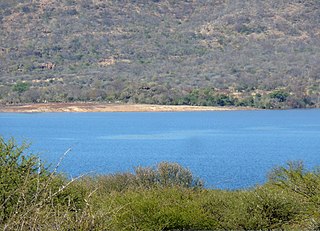
The De Hoop Dam is a gravity dam on the Steelpoort River, near Burgersfort, Limpopo, South Africa. Its purpose is to enable the extraction of rich mineral deposits in the eastern Limpopo province, and to supply water to towns, industries and communities in the Sekhukhune district, where service delivery was of a poor standard.
The Tongwane River is a river in Limpopo Province, South Africa. It flows southward and is a tributary of the Olifants River, joining it southeast of Polokwane.
The Makhutswi River is a short river in Limpopo Province, South Africa. It flows northeastwards and is a tributary of the Olifants River, joining it in its central basin.

