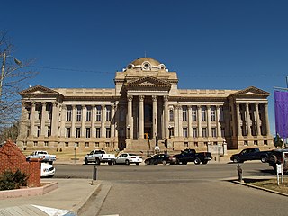
Pueblo County is a county located in the U.S. state of Colorado. As of the 2020 census, the population was 168,162. The county seat is Pueblo. The county was named for the historic city of Pueblo which took its name from the Spanish language word meaning "town" or "village". Pueblo County comprises the Pueblo, CO Metropolitan Statistical Area.

Ordway is a Statutory Town in and the county seat of Crowley County, Colorado, United States, that is also the most populous community in the county. The population was 1,066 at the 2020 census.

Larkspur is a home rule municipality in Douglas County, Colorado, United States. The town population was 206 at the 2020 census. Each year, on weekends in June, July and August, the Colorado Renaissance Festival is held in the hills just west of the town. The town is served by Larkspur Elementary School, a K-6 school in the Douglas County school district. The according to William Bright the town was named for the plains larkspur.
Eagle is the Statutory Town that is the county seat of Eagle County, Colorado, United States. The town population was 7,511 at the 2020 United States Census, a +15.41% increase since the 2010 United States Census. Eagle is the part of the Edwards, CO Micropolitan Statistical Area.

Dolores is a Statutory Town located in Montezuma County, Colorado, United States. The town population was 885 at the 2020 United States Census.

Fowler is a statutory town located in northwestern Otero County, Colorado, United States. The town population was 1,253 at the 2020 United States Census.

Boone is a Statutory Town located in Pueblo County, Colorado, United States. The town population was 305 at the 2020 United States Census.

Rye is a Statutory Town in Pueblo County, Colorado, United States. The population was 206 at the 2020 census.

Acomita Lake is a census-designated place (CDP) in Cibola County, New Mexico, United States. The population was 339 at the 2020 census.

Union Township is a township in Jefferson County, Pennsylvania, United States. The population was 845 at the 2020 census. The name was derived from the term applied to the country of the United States.

Interstate 76 (I-76) is an east–west Interstate Highway in the Western United States that runs from I-70 in Arvada, Colorado – near Denver – to an interchange with I-80 near Big Springs, Nebraska. The highway measures 187.29 miles (301.41 km) long, all but approximately three miles (4.8 km) of which is in Colorado. Along the route, the highway runs concurrent with US Route 6 (US 6), US 85 in the Denver metropolitan area, and US 34 from Wiggins to Fort Morgan. It has no auxiliary Interstates, but it has two business routes that are located in northeastern Colorado. This route is not connected with the other I-76 that spans from Ohio to New Jersey.

The Pueblo Chemical Depot is a chemical weapons storage site located in Pueblo County, Colorado, United States. The Pueblo Chemical Depot was one of the last two sites in the United States with chemical munitions and chemical material. The Pueblo Chemical Agent Destruction Pilot Plant (PCAPP) which is under the Program Executive Office, Assembled Chemical Weapons Alternatives program destroyed its stockpile of 155mm and 105mm artillery shells and 4.2-inch mortars, all of which contained a form of the chemical agent mustard gas.

The Diocese of Pueblo is a Latin Church ecclesiastical territory, or diocese, of the Catholic Church in southern Colorado in the United States. It is a suffragan diocese in the ecclesiastical province of the metropolitan Archdiocese of Denver.
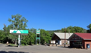
Beulah is an unincorporated community and a post office located within the Beulah Valley census-designated place in Pueblo County, Colorado, United States. The Beulah Post Office has the ZIP code 81023. Beulah is a part of the Beulah Valley CDP. Beulah lies along State Highway 78 about 21 miles southwest of Pueblo, in the foothills of the Wet Mountains.
North Avondale is an unincorporated community in Pueblo County, Colorado, United States. The U.S. Post Office at Avondale now serves North Avondale postal addresses.

U.S. Route 50 (US 50) is a part of the U.S. Highway System that travels from West Sacramento, California, to Ocean City, Maryland. In the U.S. state of Colorado, US 50 is a major highway crossing through the lower midsection of the state. It connects the Western Slope with the lower Front Range and the Arkansas Valley. The highway serves the areas of Pueblo and Grand Junction as well as many other smaller areas along its corridor. The long-term project to widen the highway from two lanes to a four lane expressway between Grand Junction and Montrose was completed in January 2005. Only about 25% of the remainder of highway 50 in Colorado is four lane expressway.

Interstate 25 (I-25) in the US state of New Mexico follows the north–south corridor through Albuquerque and Santa Fe. It replaced U.S. Route 85 (US 85), which is no longer signed, but still exists in route logs sharing the I-25 alignment. I-25 starts in New Mexico at an interchange with I-10 in Las Cruces and extends roughly 460 miles (740 km) before reaching Colorado. I-25 passes through principally rural land through central New Mexico and passes through or near the cities of Las Cruces, Truth or Consequences, Socorro, Belen, Albuquerque, Santa Fe, Las Vegas, and Raton.

In the US state of Colorado, Interstate 25 (I-25) follows the north–south corridor through Colorado Springs and Denver. The highway enters the state from the north near Carr and exits the state near Starkville. The highway also runs through the cities of Fort Collins, Broomfield, Loveland, and Pueblo. The route is concurrent with U.S. Route 87 (US 87), which is unsigned, through the entire length of the state. I-25 replaced US 87 and most of US 85 for through traffic.

Saint Charles Reservoir is the name of three reservoirs in Pueblo County, Colorado. The first one, called just Saint Charles Reservoir, is located in the mountains of southwestern Pueblo County, southwest of Beulah, at an elevation of 8,894 feet. It is located at 38°00′00″N105°02′35″W.

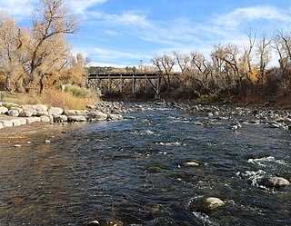
Salt Creek is a tributary of the Arkansas River in Pueblo County, Colorado in the United States. Salt Creek, Colorado, an unincorporated community and census-designated place just east of Pueblo, takes its name from the creek.

