Sherrelwood is an unincorporated community and a census-designated place (CDP) located in and governed by Adams County, Colorado, United States. The CDP is a part of the Denver–Aurora–Lakewood, CO Metropolitan Statistical Area. The population of the Sherrelwood CDP was 18,287 at the United States Census 2010. Denver post office 80221 serves the area.

Strasburg is an unincorporated town located just 30 minutes east of downtown Denver along the I-70 corridor. It is home to Strasburg School District 31-J, and there are several small businesses, medical clinics, and a post office. Strasburg is a census-designated place (CDP) located in and governed by Adams and Arapahoe counties, Colorado, United States. The CDP is a part of the Denver–Aurora–Lakewood, CO Metropolitan Statistical Area. The Strasburg post office has the ZIP Code 80136. At the United States Census 2020, the population of the Strasburg CDP was 3,307.

Columbine is census-designated place (CDP) in and governed by Jefferson and Arapahoe counties in Colorado, United States. The CDP is a part of the Denver–Aurora–Lakewood, CO Metropolitan Statistical Area. Located primarily in Jefferson County, Columbine lies immediately south of Denver. The population of the Columbine CDP was 25,229 at the United States Census 2020. The community lies in ZIP code 80123.

Edwards is an unincorporated town, a post office, and a census-designated place (CDP) located in and governed by Eagle County, Colorado, United States. Edwards is the principal town of the Edwards, CO Micropolitan Statistical Area. The Edwards post office has the ZIP Code 81632. At the United States Census 2010, the population of the Edwards CDP was 10,266, while the population of the 81632 ZIP Code Tabulation Area was 10,267. The Edwards Metropolitan District provides services.

Stratmoor is an unincorporated community and a census-designated place (CDP) located in and governed by El Paso County, Colorado, United States. The CDP is a part of the Colorado Springs, CO Metropolitan Statistical Area. The population of the Stratmoor CDP was 6,518 at the United States Census 2020. The Colorado Springs post office serves the area.

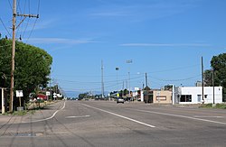
Penrose is a census-designated place (CDP) and post office located in and governed by Fremont County, Colorado, United States. The CDP is a part of the Cañon City, CO Micropolitan Statistical Area. The Penrose post office has the ZIP Code 81240. At the United States Census 2020, the population of the Penrose CDP was 3,685.

Evergreen is an unincorporated town, a post office, and a census-designated place (CDP) located in and governed by Jefferson County, Colorado, U.S. The CDP is a part of the Denver–Aurora–Lakewood, CO Metropolitan Statistical Area. The Evergreen post office has the ZIP Codes 80439 and 80437. At the United States Census 2020, the population of the Evergreen CDP was 9,307. The Evergreen Metropolitan District provides services.

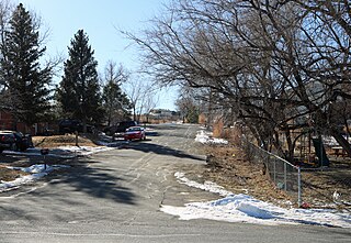
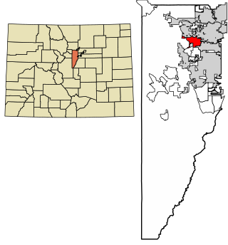
Indian Hills is an unincorporated town, a post office, and a census-designated place (CDP) located in and governed by Jefferson County, Colorado, United States. The CDP is a part of the Denver–Aurora–Lakewood, CO Metropolitan Statistical Area. The Indian Hills post office has the ZIP code 80454. At the United States Census 2010, the population of the Indian Hills CDP was 1,280, while the population of the 80454 ZIP Code Tabulation Area was 1,224.

Avondale is a census-designated place (CDP) and post office in and governed by Pueblo County, Colorado, United States. The CDP is a part of the Pueblo, CO Metropolitan Statistical Area. The Avondale post office has the ZIP Code 81022. At the United States Census 2020, the population of the Avondale CDP was 594, while the population of the 81022 ZIP Code Tabulation Area was 1,624 including adjacent areas.
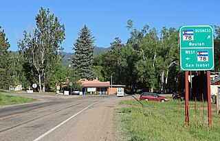
Beulah Valley is a census-designated place (CDP) in and governed by Pueblo County, Colorado, United States. The CDP is a part of the Pueblo, CO Metropolitan Statistical Area. The population of the Beulah Valley CDP was 518 at the United States Census 2020. The Beulah post office (Zip Code 81023) serves the area.

Colorado City is a census-designated place (CDP) and post office in and governed by Pueblo County, Colorado, United States. The CDP is a part of the Pueblo, CO Metropolitan Statistical Area. The Colorado City post office has the ZIP Code 81019. At the United States Census 2020, the population of the Colorado City CDP was 2,237. The Colorado City Metropolitan District provides services.

Pueblo West is a census-designated place (CDP) in and governed by Pueblo County, Colorado, United States. The CDP is part of the Pueblo, CO Metropolitan Statistical Area. The population of the Pueblo West CDP was 33,086 according to the United States Census 2020. The Pueblo West Metropolitan District provides services. The Pueblo post office (Zip Code 81007) serves Pueblo West postal addresses.

Salt Creek is an unincorporated community and a census-designated place (CDP) located in and governed by Pueblo County, Colorado, United States. The CDP is a part of the Pueblo, CO Metropolitan Statistical Area. The population of the Salt Creek CDP was 507 at the United States Census 2020. The Pueblo post office (Zip Code 81006) serves the area.

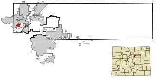
Grand View Estates is an unincorporated community and a census-designated place (CDP) located in and governed by Douglas County, Colorado, United States. The CDP is a part of the Denver–Aurora–Lakewood, CO Metropolitan Statistical Area. The population of the Grand View Estates CDP was 528 at the United States Census 2010. The area lies in ZIP code 80134..

Security-Widefield is a census-designated place (CDP) comprising the unincorporated communities of Security and Widefield located in and governed by El Paso County, Colorado, United States. The CDP is a part of the Colorado Springs, CO Metropolitan Statistical Area. The population of the Security-Widefield CDP was 32,882 at the United States Census 2010. El Paso County governs the unincorporated communities. Both the Colorado Springs post office and the Fountain post office serve the area.
East Pleasant View is an unincorporated community and a census-designated place (CDP) located in and governed by Jefferson County, Colorado, United States. The CDP is a part of the Denver–Aurora–Lakewood, CO Metropolitan Statistical Area. The population of the East Pleasant View CDP was 356 at the United States Census 2010. The Pleasant View Metropolitan District provides services. The Golden Post Office serves the area.

West Pleasant View is an unincorporated community and a census-designated place (CDP) located in and governed by Jefferson County, Colorado, United States. The CDP is a part of the Denver–Aurora–Lakewood, CO Metropolitan Statistical Area. The population of the West Pleasant View CDP was 3,840 at the United States Census 2010. The Pleasant View Metropolitan District provides services. The Golden post office serves the area.

Cloverleaf is a census-designated place (CDP) in east central Harris County, Texas, United States. The population was 24,100 at the 2020 census.
Fairmount is an unincorporated community and a census-designated place (CDP) in Jefferson County, Colorado, United States. The CDP is a part of the Denver–Aurora–Lakewood, CO Metropolitan Statistical Area. The population of the Fairmount CDP was 7,559 at the United States Census 2010. ZIP code 80403 applies to addresses in Fairmount.

Blende is a Census-designated place (CDP) in and governed by Pueblo County, Colorado, United States. The CDP is a part of the Pueblo, CO Metropolitan Statistical Area. The population of the Blende CDP was 788 at the United States Census 2020. The Pueblo post office (Zip Code 81006) serves the area.