Storrington

Last updated

Storrington
Storrington.JPG
West Sussex UK location map.svg
Red pog.svg
Storrington
Location within West Sussex
OS grid reference TQ087142
Civil parish
District
Shire county
Region
Country England
Sovereign state United Kingdom
Post town PULBOROUGH
Postcode district RH20
Dialling code 01903
Police Sussex
Fire West Sussex
Ambulance South East Coast
UK Parliament
List of places
UK
England
West Sussex
50°55′04″N0°27′17″W / 50.91776°N 0.45459°W / 50.91776; -0.45459

Storrington is a town and former civil parish, now in the parish of Storrington and Sullington, in the Horsham district of West Sussex, England. Storrington lies at the foot of the north side of the South Downs. As of 2021 it had a population of around 6,000. [1] It has one main shopping street (High Street). The A283 road runs directly through the town and connects Storrington to Steyning in the east and Pulborough in the west. It is three miles west of Washington.

Contents

History

Storrington is listed in the Domesday Book as "Estorchestone", meaning a place well known for storks. A charter to hold a regular market on Wednesdays was granted by Henry IV in 1400, together with permissions for three fairs during the year, on Mayday, Wednesday of Whit week and the Feast of Martin on 11 November. [2] Tanning and blacksmithing were also important industries and only in the 20th century did these roles fade away. Rabbit breeding was another significant industry reflected in a number of local place names including 'The Warren', 'Warren Hill', 'Sullington Warren' and 'Warren Croft'. This working/small industry background has however, left little behind architecturally. Nikolaus Pevsner, noted only the small door in Browns Lane, the church, and the Dominican convent known as the Abbey to be historically significant.

The Cinema Museum, London holds home movies of Storrington from 1950. [3]

In 1961 the parish had a population of 2784. [4] On 1 April 2003 the parish was abolished and merged with Sullington to form "Storrington & Sullington". [5]

Community

Since 1945 Storrington has expanded with a variety of housing projects which enlarged the village. [6] It is possible to be in open countryside in a few minutes from the town centre when walking towards the downs or one of the commons.

The nearest towns are Worthing, approximately 10 mi (16 km) to the south, followed by Horsham, approximately 13 mi (21 km) to the north. The nearest train stations are at Pulborough and Amberley. Current public transport provision consists of two hourly bus routes: the 1 between Worthing and Midhurst (operated by Stagecoach South), and the 100 between Burgess Hill and Pulborough (operated by Compass Travel), both stopping at the bus station outside of Waitrose.

From the town centre there is walking access to the 100-mile-long (160-kilometre) trail, the South Downs Way. From Chantry Hill or Kithurst Hill there are views across the English Channel to the south and opposite, to the North Downs. On a clear day you can see the Isle of Wight. [7]

Kithurst Hill which rises steeply above the village is marked at the summit by a trig point, 699 feet (213 metres) above sea level.

Sport and leisure

Trig Point Kithurst Hill Trig Point Kithurst Hill.jpg
Trig Point Kithurst Hill

Sport and leisure facilities include a recreation ground with football and cricket pitches and a leisure centre. Storrington has a Non-League football club Storrington F.C., who play at the recreation ground.

Storrington is thinly disguised as the home of the home team in Hugh de Sélincourt's 1924 novel The Cricket Match, complete with chestnut trees and duck pond. In later editions a cartoon map of the town is used as end pages. John Parker wrote what was effectively a sequel in The Village Cricket Match in 1977. [8]

Landmarks

St Joseph's Hall in Greyfriars Lane is a Grade II listed [9] former residence of the Bishop of Arundel and Brighton. It was built as a private house for US businessman George Trotter in 1910, and then sold to a French religious order, the Norbertines. In 1956 it was used by Vincent and Nona Byrne as a home for refugees from the Hungarian uprising. [10]

Parham Park, towards Pulborough, is a country house with rolling parkland with a large herd of maintained deer. It is open most weekends to visitors. There is also the private Edwin Lutyens built Little Thakeham nearby. [11]

Places of worship include St Mary's [12] on Church Street, which is the main Church of England place of worship, and the Priory of Our Lady of England [12] on Monastery Lane, which is the Roman Catholic parish church of Storrington. The Roman Catholic bishops of Arundel lived nearby for a while. Other Christian denominations have places as well, including the Methodists and Jehovah's Witnesses.

Twinning

Storrington is twinned with the commune of Villerest in the Loire department of central France. [13]

Related Research Articles

<span class="mw-page-title-main">West Sussex</span> County of England

West Sussex is a ceremonial county in South East England. It is bordered by Surrey to the north, East Sussex to the east, the English Channel to the south, and Hampshire to the west. The largest settlement is Crawley, and the county town is the city of Chichester.

<span class="mw-page-title-main">Steyning</span> Town in West Sussex, England

Steyning is a town and civil parish in the Horsham district of West Sussex, England. It is located at the north end of the River Adur gap in the South Downs, four miles (6.4 km) north of the coastal town of Shoreham-by-Sea.

<span class="mw-page-title-main">Washington, West Sussex</span> Human settlement in England

Washington is a village and civil parish in the Horsham District of West Sussex, England. It is located five miles west of Steyning and three miles east of Storrington on the A24 between Horsham and Worthing. The parish covers an area of 1,276 hectares. In the 2001 census 1,930 people lived in 703 households, of whom 820 were economically active. At the 2011 Census the population of the civil parish was 1,867.

<span class="mw-page-title-main">Arundel and South Downs (UK Parliament constituency)</span> Parliamentary constituency in the United Kingdom, 1997 onwards

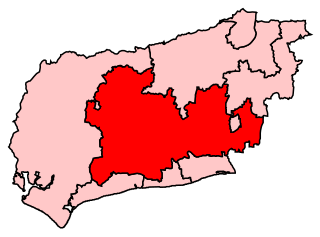
Arundel and South Downs is a constituency in West Sussex created in 1997 and represented in the House of Commons of the UK Parliament since 2019 by Andrew Griffith of the Conservative Party.

<span class="mw-page-title-main">Pulborough</span> Human settlement in England

Pulborough is a large village and civil parish in the Horsham district of West Sussex, England, with some 5,000 inhabitants. It is located almost centrally within West Sussex and is 42 miles (68 km) south west of London. It is at the junction of the north–south A29 and the east–west A283 roads.

<span class="mw-page-title-main">Storrington and Sullington</span> Human settlement in England

Storrington and Sullington is the name of a civil parish in the Horsham District of West Sussex, England. The parish covers both the town of Storrington and the village of Sullington.

<span class="mw-page-title-main">Billingshurst</span> Human settlement in England

Billingshurst is a village and civil parish in the Horsham District of West Sussex, England. The village lies on the A29 road at its crossroads with the A272, 6 miles (10 km) south-west of Horsham and 5.5 miles (9 km) north-east of Pulborough.

<span class="mw-page-title-main">Broadbridge Heath</span> Human settlement in England

Broadbridge Heath is a village and civil parish in the Horsham district of West Sussex, England. It is about two miles (3 km) west from the historic centre of Horsham. The population of Broadbridge Heath has increased considerably in the first two decades of the twenty-first century because of large scale housing development.

<span class="mw-page-title-main">Sullington</span> Human settlement in England

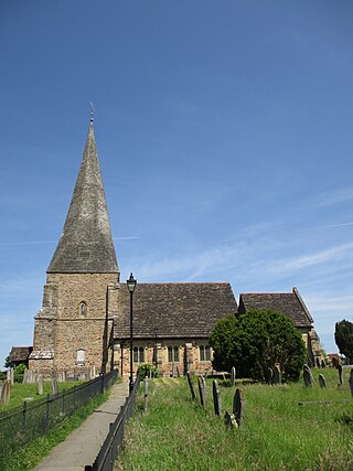
Sullington is a village and former civil parish, now in the parish of Storrington and Sullington, in the Horsham district of West Sussex, England. The village lies on the A283 road west of the A24 road, 20 miles (32 km) south of Horsham. In 1961 the parish had a population of 1354. On 1 April 2003 the parish was abolished and merged with Storrington to form "Storrington & Sullington".

<span class="mw-page-title-main">Thakeham</span> Human settlement in England

Thakeham is a village and civil parish located north of the South Downs in the Horsham District of West Sussex, England. The village is situated approximately 12 miles south-west of Horsham and 11 miles north of the sea-side town of Worthing. Its nearest large village is Storrington. The parish includes the hamlets of Abingworth and Goose Green and has a land area of 1170.6 hectares.

<span class="mw-page-title-main">Warminghurst</span> Human settlement in England

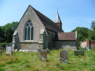
Warminghurst is a village and former civil parish, now in the parish of Thakeham, in the Horsham district of West Sussex, England. It lies on the Ashington to Heath Common road 2.4 miles (3.9 km) northeast of Storrington. In 1931 the parish had a population of 93. On 1 April 1933 the parish was abolished and merged with Ashington.

<span class="mw-page-title-main">St Edmund Church, Godalming</span> Church in Surrey , United Kingdom

St Edmund's Church is the Roman Catholic parish church of Godalming, a town in the English county of Surrey. It was built in 1906 to the design of Frederick Walters and is a Grade II listed building. The church stands on a "dramatic hillside site" on the corner of Croft Road just off Flambard Way close to the centre of the town.

Religion in Sussex has been dominated over the last 1,400 years by Christianity. Like the rest of England, the established church in Sussex is the Church of England, although other Christian traditions exist. After Christianity, the religion with the most adherents is Islam, followed by Hinduism, Buddhism, Judaism and Sikhism.

The history of Christianity in Sussex includes all aspects of the Christianity in the region that is now Sussex from its introduction to the present day. Christianity is the most commonly practised religion in Sussex.

<span class="mw-page-title-main">Sullington Warren</span>

Sullington Warren is a 24.7-hectare (61-acre) biological Site of Special Scientific Interest in Storrington in West Sussex. The site includes several tumuli which are Scheduled Monuments.

References

  1. Parish Population Projections Archived 2005-08-28 at the Wayback Machine
  2. "Gazetteer of markets and fairs in England and Wales to 1516". Archived from the original on 16 June 2011. Retrieved 12 August 2009.
  3. "Cinema Museum Home Movie Database.xlsx". Google Docs. Retrieved 20 September 2023.
  4. "Population statistics Storrington CP/AP through time". A Vision of Britain through Time . Retrieved 12 May 2023.
  5. "Worthing Registration District". UKBMD. Retrieved 12 May 2023.
  6. "Storrington - At Home Estates". www.athomeestates.co.uk. Retrieved 12 December 2022.
  7. "Outdoor activities - Storrington: walking, cycling, riding, gliding". Storrington, West Sussex. Retrieved 12 December 2022.
  8. "A gentleman's game". The Argus. Retrieved 12 December 2022.
  9. "St Joseph's Hall, Storrington". British Listed Buildings. Archived from the original on 17 November 2015. Retrieved 23 January 2013.
  10. "Tea and sympathy for Bishop". Daily Telegraph. Archived from the original on 1 March 2016. Retrieved 3 April 2018.
  11. "Little Thakeham". British Listed Buildings. Archived from the original on 14 October 2014. Retrieved 9 July 2013.
  12. 1 2 "Churches - Storrington: places of worship". Storrington. Archived from the original on 26 March 2020. Retrieved 26 March 2020.
  13. "Twinning plaque in Storrington village centre". Archived from the original on 25 March 2017. Retrieved 8 December 2017.