Brackish water, sometimes termed brack water, is water occurring in a natural environment that has more salinity than freshwater, but not as much as seawater. It may result from mixing seawater and fresh water together, as in estuaries, or it may occur in brackish fossil aquifers. The word comes from the Middle Dutch root brak. Certain human activities can produce brackish water, in particular civil engineering projects such as dikes and the flooding of coastal marshland to produce brackish water pools for freshwater prawn farming. Brackish water is also the primary waste product of the salinity gradient power process. Because brackish water is hostile to the growth of most terrestrial plant species, without appropriate management it is damaging to the environment.

Physical oceanography is the study of physical conditions and physical processes within the ocean, especially the motions and physical properties of ocean waters.

Thermohaline circulation (THC) is a part of the large-scale ocean circulation that is driven by global density gradients created by surface heat and freshwater fluxes. The adjective thermohaline derives from thermo- referring to temperature and -haline referring to salt content, factors which together determine the density of sea water. Wind-driven surface currents travel polewards from the equatorial Atlantic Ocean, cooling en route, and eventually sinking at high latitudes. This dense water then flows into the ocean basins. While the bulk of it upwells in the Southern Ocean, the oldest waters upwell in the North Pacific. Extensive mixing therefore takes place between the ocean basins, reducing differences between them and making the Earth's oceans a global system. The water in these circuits transport both energy and mass around the globe. As such, the state of the circulation has a large impact on the climate of the Earth.

A thermocline is a distinct layer based on temperature within a large body of fluid with a high gradient of distinct temperature differences associated with depth. In the ocean, the thermocline divides the upper mixed layer from the calm deep water below.

The spring bloom is a strong increase in phytoplankton abundance that typically occurs in the early spring and lasts until late spring or early summer. This seasonal event is characteristic of temperate North Atlantic, sub-polar, and coastal waters. Phytoplankton blooms occur when growth exceeds losses, however there is no universally accepted definition of the magnitude of change or the threshold of abundance that constitutes a bloom. The magnitude, spatial extent and duration of a bloom depends on a variety of abiotic and biotic factors. Abiotic factors include light availability, nutrients, temperature, and physical processes that influence light availability, and biotic factors include grazing, viral lysis, and phytoplankton physiology. The factors that lead to bloom initiation are still actively debated.
In oceanography, a halocline is a cline, a subtype of chemocline caused by a strong, vertical salinity gradient within a body of water. Because salinity affects the density of seawater, it can play a role in its vertical stratification. Increasing salinity by one kg/m3 results in an increase of seawater density of around 0.7 kg/m3.

A pycnocline is the cline or layer where the density gradient is greatest within a body of water. An ocean current is generated by the forces such as breaking waves, temperature and salinity differences, wind, Coriolis effect, and tides caused by the gravitational pull of celestial bodies. In addition, the physical properties in a pycnocline driven by density gradients also affect the flows and vertical profiles in the ocean. These changes can be connected to the transport of heat, salt, and nutrients through the ocean, and the pycnocline diffusion controls upwelling.

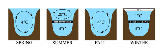
Lake stratification is the tendency of lakes to form separate and distinct thermal layers during warm weather. Typically stratified lakes show three distinct layers: the epilimnion, comprising the top warm layer; the thermocline, the middle layer, whose depth may change throughout the day; and the colder hypolimnion, extending to the floor of the lake.
Isopycnals are layers within the ocean that are stratified based on their densities and can be shown as a line connecting points of a specific density or potential density on a graph. Isopycnals are often displayed graphically to help visualize "layers" of the water in the ocean or gases in the atmosphere in a similar manner to how contour lines are used in topographic maps to help visualize topography.
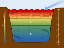
Ocean stratification is the natural separation of an ocean's water into horizontal layers by density, which is generally stable because warm water floats on top of cold water, and heating is mostly from the sun, which reinforces that arrangement. Stratification is reduced by wind-forced mechanical mixing, but reinforced by convection. Stratification occurs in all ocean basins and also in other water bodies. Stratified layers are a barrier to the mixing of water, which impacts the exchange of heat, carbon, oxygen and other nutrients. The surface mixed layer is the uppermost layer in the ocean and is well mixed by mechanical (wind) and thermal (convection) effects. Climate change is causing the upper ocean stratification to increase.
The oceanic or limnological mixed layer is a layer in which active turbulence has homogenized some range of depths. The surface mixed layer is a layer where this turbulence is generated by winds, surface heat fluxes, or processes such as evaporation or sea ice formation which result in an increase in salinity. The atmospheric mixed layer is a zone having nearly constant potential temperature and specific humidity with height. The depth of the atmospheric mixed layer is known as the mixing height. Turbulence typically plays a role in the formation of fluid mixed layers.
Bottom water is the lowermost water mass in a water body, by its bottom, with distinct characteristics, in terms of physics, chemistry, and ecology.
Estuarine water circulation is controlled by the inflow of rivers, the tides, rainfall and evaporation, the wind, and other oceanic events such as an upwelling, an eddy, and storms. Estuarine water circulation patterns are influenced by vertical mixing and stratification, and can affect residence time and exposure time.

The Barrier layer in the ocean is a layer of water separating the well-mixed surface layer from the thermocline.
In oceanography, a front is a boundary between two distinct water masses. The formation of fronts depends on multiple physical processes and small differences in these lead to a wide range of front types. They can be as narrow as a few hundreds of metres and as wide as several tens of kilometres. While most fronts form and dissipate relatively quickly, some can persist for long periods of time.

A river plume is a freshened water mass that is formed in the sea as a result of mixing of river discharge and saline seawater. River plumes are formed in coastal sea areas at many regions in the World. River plumes generally occupy wide, but shallow sea surface layer bounded by sharp density gradient. The area of a river plume is 3-5 orders of magnitude greater than its depth, therefore, even small rivers with discharge rates ~1–10 m/s form river plumes with horizontal spatial extents ~10–100 m. Areas of river plumes formed by the largest World rivers are ~100–1000 km2. Despite relatively small volume of total freshwater runoff to the World Ocean, river plumes occupy up to 21% of shelf areas of the World Ocean, i.e., several million square kilometers.
Freshwater phytoplankton is the phytoplankton occurring in freshwater ecosystems. It can be distinguished between limnoplankton, heleoplankton, and potamoplankton. They differ in size as the environment around them changes. They are affected negatively by the change in salinity in the water.
Stable stratification of fluids occurs when each layer is less dense than the one below it. Unstable stratification is when each layer is denser than the one below it.
Eddy pumping is a component of mesoscale eddy-induced vertical motion in the ocean. It is a physical mechanism through which vertical motion is created from variations in an eddy's rotational strength. Cyclonic (Anticyclonic) eddies lead primarily to upwelling (downwelling) in the Northern Hemisphere and vice versa in the Southern hemisphere. It is a key mechanism driving biological and biogeochemical processes in the ocean such as algal blooms and the carbon cycle.
An anchialine system is a landlocked body of water with a subterranean connection to the ocean. Depending on its formation, these systems can exist in one of two primary forms: pools or caves. The primary differentiating characteristics between pools and caves is the availability of light; cave systems are generally aphotic while pools are euphotic. The difference in light availability has a large influence on the biology of a given system. Anchialine systems are a feature of coastal aquifers which are density stratified, with water near the surface being fresh or brackish, and saline water intruding from the coast at depth. Depending on the site, it is sometimes possible to access the deeper saline water directly in the anchialine pool, or sometimes it may be accessible by cave diving.