Marrowstone is a census-designated place (CDP) in Jefferson County, Washington, United States. The population was 844 at the 2010 census. All Marrowstone addresses are in Nordland, Washington, and the ZIP code for Marrowstone Island is 98358.
Raft Island is a private island and CDP located near the Pierce County community of Rosedale, Washington, United States. Gig Harbor, Washington is the nearest incorporated town, although unincorporated Artondale is much closer. The island features approximately 200 homes on 160 acres. All of these homes are served through the Gig Harbor post office.

Fidalgo Island is an island in Skagit County, Washington, located about 60 mi (97 km) north of Seattle. To the east, it is separated from the mainland by the Swinomish Channel, and from Whidbey Island to the south by Deception Pass. The island is named after the Spanish explorer and cartographer Salvador Fidalgo, who explored the area in 1790.

Guemes Island is a small island in western Skagit County, Washington, United States. It is located north of Fidalgo Island and the city of Anacortes, and is accessible by private boat and by the Guemes Island ferry operated by Skagit County.

The Colvos Passage is a tidal strait within Puget Sound in the American state of Washington running west of Vashon Island between the island and the Kitsap Peninsula. It lies just north of the Dalco Passage. Colvos Passage has a permanent predominantly northbound current, in contrast to the rest of Puget Sound which varies with the tide. The communities of Fragaria, Olalla, Sunrise Beach, Spring Beach, Maplewood, Lisabeula, Paradise Cove and Sylvan Beach are located on Colvos Passage.

Agate Pass or Agate Passage is a high-current tidal strait in Puget Sound connecting Port Madison and mainland Kitsap County in the US state of Washington. It lies between Bainbridge Island and the mainland of the Kitsap Peninsula near Suquamish. It leads south towards Bremerton, extending about one mile (1.6 km) in a straight, southwesterly direction. The depth is about 20 feet (6.1 m). The shores are wooded and fairly steep. The shoreline is mostly rocky and fringed with kelp to Point Bolin. The tidal currents have velocities up to six knots; the flood tide sets southwesterly, and the ebb tide northeasterly.
Sinclair Island is an island in the U.S. state of Washington. It is a part of, and lies off the western shore of mainland Skagit County. The island has a land area of 4.109 km2 and is home to only a few private residents.
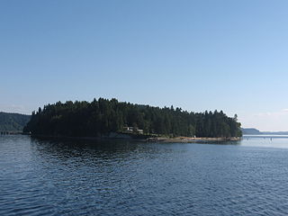
Crane Island is one of the San Juan Islands in San Juan County, Washington, United States. It lies just off the southwestern shore of Orcas Island, between it and the northwest corner of Shaw Island. Crane Island has a land area of 0.956 km². The 2000 census reported a population of 20 permanent residents.
Vendovi Island is an island in the San Juan Islands of Washington State. Located in Skagit County, Washington, United States, Vendovi Island lies across Samish Bay from mainland Skagit County, between Guemes Island and Lummi Island. Vendovi Island has a land area of 220.24 acres (89.13 ha) and a population of two persons was reported as of the 2000 census. The Island was named after a Fijian High Chief Ro Veidovi who was brought to North America by the Wilkes Expedition.
Eliza Island is located in the western part of Bellingham Bay in the U.S. state of Washington. It lies just east of the southern part of Lummi Island, in Whatcom County. Eliza Island has a land area of 0.571 km2. Its population was ten persons as of the 2010 census.

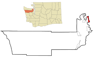
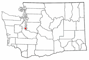
Harstine Island is an island in Mason County, Washington, United States. The US Census recognizes it as an unincorporated community. The island is located west of Case Inlet in southern Puget Sound, 16 km (9.9 mi) north of Olympia. It has a land area of 48.305 km2 (18.651 sq mi), and had a population of 1,412 as of the 2010 census.

Rosario Strait is a strait in northern Washington state, separating San Juan County and Skagit and Whatcom Counties. It extends from the Strait of Juan de Fuca about 23 kilometres (14 mi) north to the Strait of Georgia. The USGS defines its southern boundary as a line extending from Point Colville on Lopez Island to Rosario Head on Fidalgo Island, and its northern boundary as a line from Point Migley on Lummi Island to the east tip of Puffin Island and then to Point Thompson on Orcas Island. Rosario Strait runs north-south between Lopez, Decatur, Blakely, and Orcas Islands on the west, and Fidalgo, Cypress, Sinclair, and Lummi Islands on the east.

Saratoga Passage lies in Puget Sound between Whidbey Island and Camano Island.
Skull Island is the name of two small islands in the San Juan Archipelago in the U.S. state of Washington. The northernmost Skull Island is located off the coast of Orcas Island in Massacre Bay, the most northern extension of the island's West Sound. It is identified as 3.2-acre (1.3 ha) Skull Island State Park Property by the Washington State Parks and Recreation Commission. It was named for holding skulls and bones of a band of Lummi who were killed by raiding Haida in 1858. Since 2013, it has been part of the San Juan Islands National Monument.
Frost Island is an island in the San Juan Islands of the U.S. state of Washington. The approximately 70-acre island has no public electric service or land-line telephone service. There is a water-taxi that runs between the island and Anacortes.
Freeman Island is a tiny island in the San Juan Islands of the U.S. state of Washington, west of Orcas Island. It is part of the San Juan Islands National Monument . The name was given by Charles Wilkes during the Wilkes Expedition of 1838–1842, originally as Freeman's Island, in honor of J.D. Freeman, the sailmaker of the expedition's Peacock.
Barnes Island is a small uninhabited island in Whatcom County, Washington, USA. It is located near Clark Island off the northeast coast of Orcas Island. There is no ferry service to it, although it has a small dock. Barnes Island is a privately held island in the San Juans, owned by Charles Bundrandt as of 2013, and is being used for Christian camps, with a permanent group house in addition to tent sites.
Hale Passage is the name of two different bodies of water in Puget Sound, in the U.S. state of Washington.
Ketron Island is an island and a census-designated place (CDP) in Pierce County, Washington, United States. The island had a population of 24 persons according to the 2000 census, and 17 persons at the 2010 census.

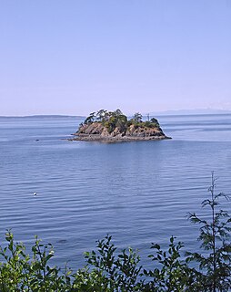
Strawberry Island is a small island in the San Juan Islands of the U.S. state of Washington. It is located in Rosario Strait near Cypress Island and closes Strawberry Bay.
