Subdivisions of the Gambia

Last updated
Divisions of the Gambia Gambia Divisions.svg
Divisions of the Gambia

The Gambia is divided into five administrative Regions (until 2007 these were known as "divisions") and one City. The divisions of the Gambia are created by the Independent Electoral Commission in accordance to Article 192 of the National Constitution. [1]

Contents

During the 2013 census, the Western region was the most populated with a population of 699,704, while the Lower River region was the least populated with 82,361. The maximum density of population was seen in Western with 396.59 persons per km2, while it was lowest in Lower River with 50.90 persons per km2. The maximum number of households was in Western region with 45,396 households as of 2003. Lower River had the highest infant mortality rate of 96 for every thousand births and under-five mortality of 137 per every thousand births. In 2003, the poverty gap ratio was greatest in Central River with 36.45% and lowest in Lower River with 19.80%.

The Local Government Act passed in 2002 superseded the previous local government acts like Local Government Act (Amended 1984), Local Government (City of Banjul) Act (Amended 1988), The Kanifing Municipal Council Act 1991 and the Provinces Act. There were six local government areas, each subdivided into districts and wards. Residents elect a mayor and councilmen, with the mayor serving as chairman of the council.

The Divisions

NameCapitalStatusPopulation
(2013) [2]
Area
(km2) [3]
DensityImage
Banjul Banjul City413,39787.784,709.47
Gambia - Banjul.svg
Central River Janjanbureh Region226,0182,894.2578.09
Gambia - Central River.svg
Lower River Mansa Konko Region82,3611,618.0050.90
Gambia - Lower River.svg
North Bank Kerewan Region221,0542,255.5098.01
Gambia - North Bank.svg
Upper River Basse Region239,9162,069.50115.93
Gambia - Upper River.svg
West Coast Brikama Region699,7041,764.25396.60
Gambia - Western.svg

The Gambia is also additionally divided into eight Local Government Areas, of which two are the City of Banjul and the Municipality of Kanifing; these two collectively form Greater Banjul, although the latter now extends to parts of Brikama LGA, the former Western Division. The other six LGAs comprise the former five Divisions, although the Central River Division was divided into two LGAs, Janjanbureh LGA in the east and Kuntaur LGA in the west. The Local Government Areas are further subdivided into 43 districts. Of these, Kombo Saint Mary (which shares Brikama as a capital with the Brikama LGA) may have been administratively merged with the Greater Banjul area. [4]

Demographics

Per 2013 census, Western region was the most populated with a population of 699,704, while Lower River was the least populated with 82,361. The maximum density of population was seen in Western with 396.59 persons per km2, while it was lowest in Lower River with 50.90 persons per km2. The maximum number of households was in Western region with 45,396 households as of 2003. Lower River had the highest infant mortality rate of 96 for every thousand births and under-five mortality of 137 per every thousand births. The poverty gap ratio was maximum in Central River with 36.45 per cent as of 2003 and lowest in Lower River with 19.80 per cent. [5] [3] The literacy rate was maximum in Western with 69.7 per cent compared to a national average of 62.9 per cent, while the lowest was in Upper River with 39 per cent as of 2007. The net enrollment ratio in primary education was maximum in Western (70 %), children entering first grade of primary school reaching last grade of primary education was 100 per cent in Northern Bank and the ratios of boys against girls in primary, secondary and tertiary education was maximum (1.13) in Lower River as of 2007. [6]

Local administration

The Gambia, along with modern-day Senegal, were colonies of France and Britain until 1894 when it became a British colony. Both the countries gained independence in 1965 and operated in a federation called Senegambia from 1982. During 1989, the confederation collapsed. In a bloodless coup, Lieutenant Yahya Jamme in 1994 and went on to win multi party elections in three subsequent elections. He has also defeated coups successfully and unlike the West African countries, the Gambia has a relative stable governance. [7] The Local Government Act passed in 2002 superseded the previous local government acts like Local Government Act (Amended 1984), Local Government (City of Banjul) Act (Amended 1988), The Kanifing Municipal Council Act 1991 and the Provinces Act. There were six local governments defined, each subdivided into districts and wards. The Mayor who is the chairperson of the council and the council members of each council are elected by people of the area. The legislation indicating the roles was not clearly defined, but the council is responsible for finance, services and planning for each sector under it. Around 25 per cent of the budget is provisioned by the central government. The council also has a Alkalo or Seyfo representative, a Chief representative, a youth nominee, a woman nominee and other nominated members of local interest groups. [8] The city and area council elections were last held during April 2002. [9]

See also

Related Research Articles

<span class="mw-page-title-main">The Gambia</span> Country in West Africa

The Gambia, officially the Republic of The Gambia, and sometimes shortened to just Gambia, is a country in West Africa. It is the smallest country within mainland Africa and is surrounded by Senegal, except for its western coast on the Atlantic Ocean. The Gambia is situated on both sides of the lower reaches of the Gambia River, the nation's namesake, which flows through the centre of The Gambia and empties into the Atlantic Ocean, and elucidates the long shape of the country. It has an area of 11,300 square kilometres (4,400 sq mi) with a population of 1,857,181 as of the April 2013 census. Banjul is the Gambian capital and the country's largest metropolitan area, while the largest cities are Serekunda and Brikama.

<span class="mw-page-title-main">Banjul</span> Capital and the center of the largest metropolitan area of The Gambia in Africa

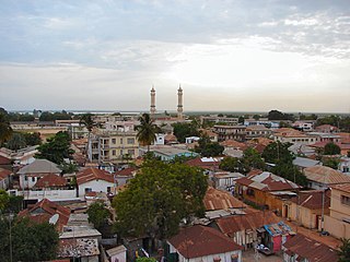
Banjul, officially the City of Banjul, is the capital and fourth largest city of The Gambia. It is the centre of the eponymous administrative division which is home to an estimated 400,000 residents, making it The Gambia's largest and most densely populated metropolitan area. Banjul is on St Mary's Island, where the Gambia River enters the Atlantic Ocean. The population of the city proper is 31,301, with the Greater Banjul Area, which includes the City of Banjul and the Kanifing Municipal Council, at a population of 413,397. The island is connected to the mainland to the west and the rest of Greater Banjul Area via bridges. There are also ferries linking Banjul to the mainland at the other side of the river.

<span class="mw-page-title-main">Provinces of Zambia</span> First-level administrative divisions of Zambia

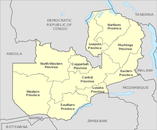
Zambia is divided into 10 provinces for administrative purposes. Each province is headed by a minister appointed by the President and there are ministries of central government for each province. The administrative head of each province is the Permanent Secretary, appointed by the President. There are Deputy Permanent Secretary, heads of government departments and civil servants at the provincial level.

<span class="mw-page-title-main">Oio Region</span> Region of Guinea-Bissau

<span class="mw-page-title-main">Brikama</span> Place in Brikama Local Government Area, The Gambia

Brikama is one of the largest cities in the Gambia. It is also called 'Satey Ba' by the locals, meaning "big town". It lies southwest of the country's capital, Banjul. Brikama is the headquarters of the Brikama Local Government Area, and is the largest city in the region containing over twenty five wards with a population of over 100,000. As per the 2013 census, the population of Brikama LGA is 730,895. It was the capital of the pre-colonial Kasa Kingdom.

<span class="mw-page-title-main">Lower River Division</span> Administrative division of the Gambia

Lower River Division is one of the five administrative divisions of the Gambia. Its capital is Mansa Konko. The city and area council elections were held during April 2002, when Wally S.M. Sanneh, an APRC candidate became the Mayor, winning unopposed. The council was led by Alliance for Patriotic Reorientation and Construction (APRC), which won all the 12 seats.

<span class="mw-page-title-main">Central River Division</span> Administrative division of the Gambia

Central River is the largest of the five administrative divisions of the Gambia. Its capital is Janjanbureh, on MacCarthy Island. The largest settlement is Bansang, with an estimated population in 2008 of 8,381.

<span class="mw-page-title-main">North Bank Division</span> Administrative division of the Gambia

North Bank was one of the five administrative divisions of the Gambia. Its capital was Kerewan. It was subsequently reorganised as the Kerewan Local Government Area (LGA), without any change in the area covered.

<span class="mw-page-title-main">Upper River Division</span> Administrative division of the Gambia

Upper River was one of the five Divisions of the Gambia. Its capital was Basse Santa Su. It was subsequently reorganised as the Basse Local Government Area, without any change in the area covered.

<span class="mw-page-title-main">West Coast Division (The Gambia)</span> Administrative division of the Gambia

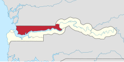
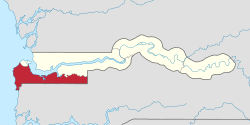
West Coast Region, originally the Western Division, also known as Foni or Fonyi, was one of the five administrative divisions of the Gambia. Its capital was Brikama. It was subsequently reorganised as the Brikama Local Government Area (LGA), without any change in the area covered.

Kerewan is a town in the Gambia. Located beside the Miniminiyang Bolong, about 60 km from the capital Banjul. It is the seat of the Kerewan Local Government Area, located on the north bank of the lower river Gambia.

The Gambia is divided into eight local government areas. They are:

  1. Banjul
  2. Basse
  3. Brikama
  4. Janjanbureh
  5. Kanifing
  6. Kerewan
  7. Kuntaur
  8. Mansakonko
<span class="mw-page-title-main">Trans-Gambia Highway</span>

The Trans-Gambia Highway is a major highway in The Gambia, running across the centre of the nation in a north–south direction.

<span class="mw-page-title-main">Districts of the Gambia</span>

The Gambia is subdivided into 43 districts. They are listed below by Local Government Area, each with its population at the 15 April 2013 census.

Kombo North/Saint Mary is one of the nine districts of the Gambia's Brikama Local Government Area, which is located to the south of the Gambia River in the southwest of the country. Kombo North/Saint Mary is in the northwest of the LGA, between Kombo South and Kanifing LGA. It is the only district in the LGA with coasts on both the Atlantic Ocean and the Gambia River, and is the most populated district in the LGA, with 344,756 inhabitants at the 2013 Census.

The tourism industry today in the Gambia started when a party of 300 Swedish tourists arrived in 1965. That pioneering trip was organised by a Swede named Bertil Harding together with the tour operators Vingresor. It was seen as an ideal place to escape the harsh winter months of Scandinavia where Europeans would enjoy not only sun, sand and beaches but also experience the excitement of a real African holiday. It also offered a new opening for an affordable holiday to increasing numbers of traveling Europeans.

<span class="mw-page-title-main">Trust Bank Limited (Gambia)</span>

Trust Bank Limited (Gambia), commonly known as Trust Bank Ltd (TBL), but also referred to as Trust Bank (Gambia), is a private commercial bank in the Gambia. It is one of the fourteen commercial banks licensed by the Central Bank of the Gambia, the national banking regulator.

The Gambia National Library Service Authority is located in Banjul, Gambia. The library was originally operated by the British Council till 1946 and was renamed to the National Library of The Gambia by 1971. The library is maintained and administered by The Gambia National Library Services Authority (GNLSA). As of 2016, the library had a collection of 115,500 books and 85 periodicals. It had more than 42 staff and more than 276 members.

The 2010 Zambian census was conducted in Zambia in 2010 under the approval of the Government of Zambia, which recorded demographic data from 13 million people and 3.2 million households. The 2010 Census of Population and Housing was conducted between 16 October and 15 November 2010, with all parts of the country covered by 30 November 2010. It was the fifth national population census exercise of Zambia since its independence in 1964, with the previous censuses conducted in 1969, 1980, 1990 and 2000. A total of 3.2 million questionnaires were used for data collection and the processing started in April 2011 by the Central Statistical Office. Optical Mark Reading (OMR) and Intelligent Character Recognition (ICR) technology were used for data capture. The census was funded by United Nations Population Fund (UNFPA), the United Kingdom AID, the United States Agency for International Development (USAID) and the African Development Bank (AfDB), who contributed close to 60 per cent of the total expenditure and rest contributed by the Ministry of Finance of the Government of Zambia.

Local elections were held in the Gambia on 20 May 2023. The elections took place following President Adama Barrow's re-election under the banner of the new National People's Party, and their subsequent victory in the 2022 parliamentary elections.

References

  1. "The Gambia - Government". The World Factbook. 19 September 2006. Retrieved 29 September 2006.
  2. "The Gambia 2013 Population and Housing Census Preliminary Results" (PDF).
  3. 1 2 "Census of The Gambia". Gambia Bureau of Statistics. 2013. Retrieved 25 November 2016.
  4. Gwillim Law (19 April 2006). "Divisions of Gambia". Administrative Divisions of Countries ("Statoids"). Retrieved 29 September 2006.
  5. "Socio-economic statistics of The Gambia". Gambia Bureau of Statistics. 2013. Retrieved 25 November 2016.
  6. "Educational statistics of The Gambia". Gambia Bureau of Statistics. 2007. Retrieved 25 November 2016.
  7. "The Gambia country profile". BBC. 5 August 2016. Retrieved 20 November 2016.
  8. Republic of The Gambia, Public Administration and Country profile (PDF) (Report). Department of Economic and Social Affairs (DESA), United Nations. 2004. p. 7. Retrieved 17 November 2016.
  9. "25 April 2002 Local Elections in The Gambia". African Elections Database. Retrieved 25 November 2016.