Upper River Division

Last updated
Upper River
Gambia 090 from KG.jpg
Gambia - Upper River.svg
Location of Upper River Region in the Gambia
CountryFlag of The Gambia.svg  Gambia
Capital Basse Santa Su
Area code(s) (+220)

Upper River was one of the five Divisions of the Gambia. Its capital was Basse Santa Su. It was subsequently reorganised as the Basse Local Government Area, without any change in the area covered.

Contents

Per 2013 census, the region had a population of 239,916 with a population density of 116. The total number of households was 12,454 as of 2003. As of 2003, the total area of the region is 2069.5 km2. The infant mortality rate was 82 for every thousand births and the under-five mortality was 110 per every thousand births. The poverty gap ratio was 25.9 per cent as of 2003 and the literacy rate was 49.5 per cent.

Geography

A street in the province 1917383-Basse Santa Su-The Gambia.jpg
A street in the province

The Gambia is the smallest country in Africa and the width of its strip-like territory never exceeds 48 km (30 mi). It is bordered by the Atlantic Ocean to the west and otherwise surrounded by Senegal. The Gambia River flows throughout the country and is the principal source of water and transport medium. The banks of the river have swampy beaches, while it has alluvial soil in all other parts, which is conducive for the growth of rice. Peanuts are the major cash crop. The weather is usually warm and dry. [1] The elevation of the country reaches to a maximum of 50 m (160 ft) above mean sea level. There are vast segments of sedimentary sandstone and claystone in the valleys of the rivers and the regions surrounding it. The river flows from Guinea and has an east-west axis. The shallow water in the coastline are important sources of fishing. There are mangrove and banto forests along the coastline. [2] Over the river segment of 487 km (303 mi), there are numerous creeks, which are locally called bolongs[ what language is this? ]. The months from June to September experience a wet season, while the remaining seven months are dry. The average annual rainfall is around 1,400 mm (55 in) in the south-east, while it is 720 mm (28 in) in the northwest. Experts have assessed that the overall rainfall during the century period between 1886 and 1992, there has been a reduction in rainfall of around 15-20 per cent and the wet season has been shortened. [3]

Demographics

Per 2013 census, the region had a population of 239,916 with a population density of 116. The total number of households was 12,454 as of 2003. As of 2003, the total area of the region is 2069.5 km2. The infant mortality rate was 82 for every thousand births and the under-five mortality was 110 per every thousand births. The poverty gap ratio was 25.9 per cent as of 2003. [4] [5] The literacy rate of the province was 49.5 compared to a national average of 62.9 per cent. The net enrollment ratio in primary education was 39 per cent, children entering first grade of primary school reaching last grade of primary education was 95 per cent and the ratios of boys against girls in primary, secondary and tertiary education was 1.11 as of 2007. [6]

Local Administration

Districts of Upper River Upper River districts.png
Districts of Upper River

The Gambia along with modern-day Senegal were colonies of French and British until 1894 when it became a British colony. Both the countries got independence in 1965 and operated in a federation called Senegambia from 1982. During 1989, the confederation collapsed. In a bloodless coup, Lieutenant Yahya Jamme in 1994 and went on to win multi-party elections in three subsequent elections. He has also defeated coups successfully and unlike the West African countries, the Gambia has a relative stable governance. [7] The Local Govemment Act passed in 2002 superseded the previous local government acts like Local Government Act (Amended 1984), Local Government (City of Banjul) Act (Amended 1988), The Kanifing Municipal Council Act 1991 and the Provinces Act. There were seven local governments defined each subdivided into districts and wards. The Mayor who is the chairperson of the council and the council members of each council is elected by people of the area. The legislations indicating the roles were not clearly defined, but the council is responsible for finance, services and planning for each sector under it. Around 25 per cent of the budget is provisioned by the central government. The council also has a Alkalo or Seyfo representative, a Chief representative, a youth nominee, a woman nominee and other nominated members of local interest groups. [8]

Upper River is divided into 4 districts, namely, Fulladu East, Kantora, Sandu and Wuli. The city and area council elections were held during April 2002, when Kanimang Sanneh, an APRC candidate became the Mayor, winning 64.2 per cent votes. The council was led by Alliance for Patriotic Reorientation and Construction (APRC), which won all fourteen seats. [9]

See also

Related Research Articles

Berea District District in Lesotho

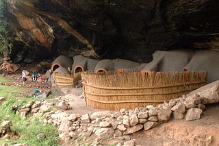
Berea is a district of Lesotho. In the west, Berea borders on the Free State Province of South Africa. Domestically, it borders on the following districts: Leribe District in the north, Thaba-Tseka District in southeast and Maseru District in the south. Teyateyaneng is the capital of the district. It is also home to the Kome Cave Dwellings. It is also the only district in Lesotho which is not named after its capital.

Oio Region Region of Guinea-Bissau

Oio is a region in Guinea-Bissau. Its capital is Farim. Other major cities and towns include Nhacra, Mansôa, Bissorã and Cumeré. The region borders Senegal to the north, the Guinea-Bissau regions of Bafatá, Bissau and Biombo to the east, the Rio Geba/Guinea-Bissau region of Quinara to the south and the Guinea-Bissau region of Cacheu to the west. There has not been any local administration since the civil war of 1998-99 and all the social services are done by organs of civil society and other government agencies. It is a coastal region covered with Mangrove swamps, rain forest and tangled forest and receives an annual rainfall of more than 1,000 mm (39 in), while the inland has savannah woodlands.

Hodh El Gharbi Region Region of Mauritania

Hodh El Gharbi is a region in southern Mauritania, with an area of 53,400 square km. The population at the 2013 census was 294,109. Its capital is Aïoun. The region borders the Mauritanian regions of Tagant to the north, Hodh Ech Chargui to the east and Assaba to the west. To the south in borders Mali, and a part of Malian territory protrudes into the region. The Aoukar basin, which formerly gave name to a greater region, is located in the northern and central part of Hodh El Gharbi, extending eastwards.

Guidimaka Region Region of Mauritania

Guidimaka is the southernmost region of Mauritania. Its capital is Sélibaby. The region borders the Mauritanian region of Assaba to the north-east, Mali to the south-east, Senegal to the south-west and the Mauritanian Gorgol Region to the west.

Gorgol Region Region of Mauritania

Gorgol is a region in southern Mauritania. Its capital is Kaédi and the Gorgol River forms parts of the landscape. Other major cities/towns include Mbout and Maghama. The region borders the Mauritanian regions of Brakna and Assaba to the north, the Mauritanian region of Guidimaka to the south-east and Senegal to the south-west. The Senegal River runs along the region's border with Senegal.

Dakhlet Nouadhibou Region Region of Mauritania

Dakhlet Nouadhibou Region is an administrative division of Mauritania. Its regional capital is Nouadhibou, which is located at its northwestern end and is home to nearly 95% of the region's population. The rest of the shoreline is sparsely populated with villages, but the east of the region is mostly uninhabited.

Brakna Region Region of Mauritania

Brakna is a region in south-west Mauritania. Its capital is Aleg. Other major cities/towns include Boghé. The region borders the Mauritanian regions of Tagant to the north-east, Assaba and Gorgol to the south-east, and Trarza to the north-west. The Sénégal River in the south-west runs along the region's border with Senegal.

Anseba Region Administrative region in northern Eritrea

Anseba Region is an administrative region of Eritrea, located in northern Eritrea. The capital and the most populous city in the region is Keren. The region is named after Anseba River, which passed through most parts of the region. The average elevation in the region is around 1,800 m (5,900 ft) to 2,100 m (6,900 ft). The hottest month is May recording temperatures up to 30 °C (86 °F), while the coldest month is December to February when it reaches freezing temperature. The region received around 508 mm (20.0 in) of rainfall and the soil is conducive for agriculture.

Gash-Barka Region Administrative region of Eritrea

Gash-Barka is an administrative region of Eritrea. It is situated in the south-west of the country, bordering the Anseba region to the north, and the Maekel (Central) and Debub (Southern) regions to the east; the country of Sudan lies to the west and Ethiopia to the south.

Southern Red Sea Region Administrative region in southern Eritrea

The Southern Red Sea Region is an administrative region of Eritrea. It lies along the southern half of the Red Sea, and contains the coastal city of Assab. It borders the Northern Red Sea Region, and has an area of around 27,600 km2 (10,700 sq mi).

Southern Region (Eritrea) Administration region in western Eritrea

Debub Region, also known as the South Region, is an administrative region of Eritrea. The region was formed on 15 April 1996, from the historical provinces of Serae and Akele Guzai. It lies along a portion of the national border with Ethiopia. As of 2005, the region had a population of 952,100 compared to a population of 839,700 in 2001. The net growth rate was 11.81 per cent. The total area of the province was 8000.00 km2 and the density was 119.01 persons per km2. The highest point in Eritrea, is Mount Soira 3,018 m (9,902 ft), is located in the region, situated east of Senafe. It shares borders with Central Region in the north, Zoba Northern Red Sea in the east, Gash Barka in the west and Ethiopia in the south. It is the largest region in the country by population.

Northern Red Sea Region Administrative region in northeastern Eritrea

The Northern Red Sea Region is an administrative region of Eritrea. It lies along the northern three quarters of the Red Sea, and includes the Dahlak Archipelago and the coastal city of Massawa.

Lower River Division Administrative division of the Gambia

Lower River Division is one of the five administrative divisions of the Gambia. Its capital is Mansa Konko. The city and area council elections were held during April 2002, when Wally S.M. Sanneh, an APRC candidate became the Mayor, winning unopposed. The council was led by Alliance for Patriotic Reorientation and Construction (APRC), which won all the 12 seats.

Central River Division Administrative division of the Gambia

Central River was the largest of the five administrative divisions of the Gambia. Its capital was Janjanbureh, on MacCarthy Island. The largest settlement was Bansang, with an estimated population in 2008 of 8,381.

North Bank Division Administrative division of the Gambia

North Bank was one of the five administrative divisions of the Gambia. Its capital was Kerewan. It was subsequently reorganised as the Kerewan Local Government Area (LGA), without any change in the area covered.

West Coast Division (The Gambia) Administrative division of the Gambia

West Coast Region, originally the Western Division, also known as Foni or Fonyi, was one of the five administrative divisions of the Gambia. Its capital was Brikama. It was subsequently reorganised as the Brikama Local Government Area (LGA), without any change in the area covered.

Luapula Province Province of Zambia

Luapula Province is one of Zambia's ten provinces located in the northern part of the country. Luapula Province is named after the Luapula River and its capital is Mansa. As per the 2010 Zambian census, the Province had a population of 991,927, which accounted for 7.57 per cent of the total Zambian population.

Subdivisions of the Gambia

The Gambia is divided into five administrative Regions and one City. The divisions of the Gambia are created by the Independent Electoral Commission in accordance to Article 192 of the National Constitution.

City of Newcastle Local government area in New South Wales, Australia

The City of Newcastle is a local government area in the Hunter region of New South Wales, Australia. The City of Newcastle incorporates much of the area of the Newcastle metropolitan area.

Sidia Sana Jatta is a Gambian politician, academic, and writer.

References

  1. McColl, R. W. (2014). Encyclopedia of World Geography, Volume 1. Infobase Publishing. p. 351. ISBN   9780816072293.
  2. Emms, Craig; Barnett, Linda; Human, Richard (2006). The Gambia. Bradt Travel Guides. ISBN   9781841621371.
  3. Jones, Michaeal (1994). Flowering Plants of the Gambia. CRC Press. ISBN   9789054101970.
  4. "Socio-economic statistics of The Gambia". Gambia Bureau of Statistics. 2013. Retrieved 25 November 2016.
  5. "Census of The Gambia". Gambia Bureau of Statistics. 2013. Retrieved 25 November 2016.
  6. "Educational statistics of The Gambia". Gambia Bureau of Statistics. 2007. Retrieved 25 November 2016.
  7. "The Gambia country profile". BBC. 5 August 2016. Retrieved 20 November 2016.
  8. Republic of The Gambia, Public Administration and Country profile (PDF) (Report). Department of Economic and Social Affairs (DESA), United Nations. 2004. p. 7. Retrieved 17 November 2016.
  9. "25 April 2002 Local Elections in The Gambia". African Elections Database. Retrieved 25 November 2016.

Coordinates: 13°23′40″N14°10′31″W / 13.39444°N 14.17528°W / 13.39444; -14.17528