Sudley, Virginia

Last updated
Sudley, Virginia
(including West Gate)
Prince William County Virginia incorporated and unincorporated areas Sudley highlighted.svg
Location in Prince William County and the state of Virginia.
Coordinates: 38°47′34″N77°29′56″W / 38.79278°N 77.49889°W / 38.79278; -77.49889 Coordinates: 38°47′34″N77°29′56″W / 38.79278°N 77.49889°W / 38.79278; -77.49889
CountryUnited States
State Virginia
County Prince William
Population
 (2010)
  Total16,203
Time zone UTC−5 (Eastern (EST))
  Summer (DST) UTC−4 (EDT)
Area code(s) 571, 703
Sudley, Virginia
(excluding West Gate)
Area
  Total1.6 sq mi (4.0 km2)
  Land1.6 sq mi (4.0 km2)
  Water0.0 sq mi (0.0 km2)
Elevation
210 ft (64 m)
Population
 (2000)
  Total7,719
  Density4,940.2/sq mi (1,907.4/km2)
FIPS code 51-76416 [1]
GNIS feature ID1760962 [2]

Sudley is a census-designated place (CDP) in Prince William County, Virginia, United States. As of the 2010 census, Sudley comprises what in the 2000 census were the Sudley and West Gate CDPs. Sudley's population including West Gate was 16,203 at the 2010 census, and excluding West Gate was 7,719 at the 2000 census.

Contents

Sudley contains the Splash Down Waterpark. Residents of Sudley are represented in the Virginia House of Delegates by Danica Roem.

Geography

Sudley is located at 38°47′34″N77°29′56″W / 38.79278°N 77.49889°W / 38.79278; -77.49889 (38.792783, 77.498784). [3]

According to the United States Census Bureau, the CDP has a total area of 1.6 square miles (4.0 km2), all of it land.

Demographics

2000 borders

As of the census [1] of 2000, there were 7,719 people, 2,640 households, and 1,998 families residing in the CDP. The population density was 4,940.2 inhabitants per square mile (1,907.4/km2). There were 2,703 housing units at an average density of 1,729.9 per square mile (667.9/km2). The racial makeup of the CDP was 75.41% White, 11.88% African American, 0.48% Native American, 3.72% Asian, 0.12% Pacific Islander, 5.10% from other races, and 3.29% from two or more races. Hispanic or Latino of any race were 9.29% of the population.

There were 2,640 households, out of which 41.5% had children under the age of 18 living with them, 59.1% were married couples living together, 11.8% had a female householder with no husband present, and 24.3% were non-families. 16.7% of all households were made up of individuals, and 2.6% had someone living alone who was 65 years of age or older. The average household size was 2.92 and the average family size was 3.30.

In the CDP, the population was spread out, with 29.1% under the age of 18, 8.7% from 18 to 24, 35.1% from 25 to 44, 22.4% from 45 to 64, and 4.7% who were 65 years of age or older. The median age was 32 years. For every 100 females, there were 98.2 males. For every 100 females age 18 and over, there were 97.7 males.

The median income for a household in the CDP was $67,033, and the median income for a family was $67,246. Males had a median income of $46,196 versus $32,038 for females. The per capita income for the CDP was $26,322. About 3.3% of families and 4.1% of the population were below the poverty line, including 7.7% of those under age 18 and none of those age 65 or over.

Related Research Articles

<span class="mw-page-title-main">Waikoloa Village, Hawaii</span> Census-designated place in Hawaii, U.S.

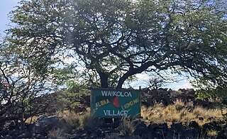
Waikōloa Village is a census-designated place (CDP) in Hawaiʻi County, Hawaii, United States. The population was 6,362 at the 2010 census, up from 4,806 at the 2000 census. The name Waikoloa is used by the local post office.

<span class="mw-page-title-main">Lake of the Woods, Illinois</span> Census-designated place in Illinois, United States

Lake of the Woods is a census-designated place (CDP) in Champaign County, Illinois, United States. The population was 2403 at the 2020 census. Lake of the Woods is in Mahomet Township and mostly surrounded by the northeast part of the village of Mahomet.

<span class="mw-page-title-main">South Gate, Maryland</span> Former census-designated place in Maryland, United States

South Gate was a census-designated place (CDP) in Anne Arundel County, Maryland, United States, for the 2000 census, at which time its population was 28,672. It was added primarily to the Glen Burnie CDP for the 2010 census.

<span class="mw-page-title-main">Lake Wynonah, Pennsylvania</span> CDP in Pennsylvania, United States

Lake Wynonah is a census-designated place (CDP) in Schuylkill County, Pennsylvania, United States. The population was 1,961 at the 2000 census, and 2,640 at the 2010 census. Lake Wynonah is a gated community with two lakes, Fawn Lake and Lake Wynonah, and as of July 2008, there are over 1200 homes and 1500 members. It is in South Manheim and Wayne Townships.

<span class="mw-page-title-main">Dooms, Virginia</span> CDP in Virginia, United States

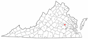
Dooms is a census-designated place (CDP) in Augusta County, Virginia, United States. The population was 1,327 at the 2010 census. It is part of the Staunton–Waynesboro Micropolitan Statistical Area.

<span class="mw-page-title-main">Lyndhurst, Virginia</span> CDP in Virginia, United States

Lyndhurst is a census-designated place (CDP) in Augusta County, Virginia, United States. The population was 1,490 at the 2010 census. It is part of the Staunton–Waynesboro Micropolitan Statistical Area.

<span class="mw-page-title-main">Idylwood, Virginia</span> Census-designated place in Virginia, United States

Idylwood is a census-designated place (CDP) in Fairfax County, Virginia, United States. The population was 17,954 as of the 2020 census. It originally developed as a suburban community along the route of the Washington and Old Dominion Railroad, and later along Virginia State Route 7. The construction of the Capital Beltway in the 1960s, and I-66 and the Orange Line of the Washington Metrorail system in the 1980s, as well as the concurrent development of nearby Tysons Corner into Washington's leading suburban business district, led to the development of several apartment, townhouse, and small-lot single-family housing complexes, as well as the high-rise Idylwood Towers condominium, in the portion of Idylwood lying to the north of I-66. The area to the south of I-66 remains primarily large-lot single-family.

<span class="mw-page-title-main">Merrifield, Virginia</span> Census-designated place in Virginia, United States

Merrifield is a census-designated place (CDP) in Fairfax County, Virginia, United States. The population was 15,212 at the 2010 census.

<span class="mw-page-title-main">East Highland Park, Virginia</span> Census-designated place in Virginia

East Highland Park is a census-designated place (CDP) in Henrico County, Virginia, in the United States. The population was 15,131 at the 2020 census.

<span class="mw-page-title-main">Lakeside, Virginia</span> Census-designated area in Virginia

Lakeside is a census-designated place (CDP) in Henrico County, Virginia, United States. It is an inner suburb of Richmond, Virginia. The population was 11,849 at the 2010 census.

<span class="mw-page-title-main">Fairview Beach, Virginia</span> Census-designated place in Virginia, United States

Fairview Beach is an unincorporated community and census-designated place (CDP) in King George County, Virginia, United States. The population was 391 at the 2010 census, which was up significantly from the 230 reported in 2000.

<span class="mw-page-title-main">Bull Run, Prince William County, Virginia</span> Census-designated place in Virginia, United States

Bull Run is a census-designated place (CDP) in Prince William County, Virginia. The population was 14,983 at the 2010 census.

<span class="mw-page-title-main">Loch Lomond, Virginia</span> Census-designated place in Virginia, United States

Loch Lomond is a census-designated place (CDP) in Prince William County, Virginia, United States. The population was 3,701 at the 2010 census. It is named after a loch in northern Scotland, Loch Lomond.

<span class="mw-page-title-main">West Gate, Prince William County, Virginia</span> Unincorporated community & Former Census-designated place in Virginia, United States

West Gate is an unincorporated community and former census-designated place (CDP) in Prince William County, Virginia, United States. The population was 7,493 at the 2000 census. It contained the now-defunct Sunnybrook Golf Club.

<span class="mw-page-title-main">Yorkshire, Virginia</span> CDP in Virginia, United States

Yorkshire is a census-designated place (CDP) in Prince William County, Virginia, United States. It is an annex of Manassas, Virginia. The population was 6,732 at the 2000 census.

<span class="mw-page-title-main">Aquia Harbour, Virginia</span> CDP in Virginia, United States

Aquia Harbour is a census-designated place (CDP) in Stafford County, Virginia, United States, 13 miles (21 km) north of Fredericksburg. The population was 6,727 at the 2010 census. Aquia Church, erected in 1757 and now a National Historic Landmark, is located west of the community.

<span class="mw-page-title-main">Amherstdale-Robinette, West Virginia</span> Former CDP in West Virginia, United States

Amherstdale-Robinette is a former census-designated place (CDP) in Logan County, West Virginia, United States. The population was 1,785 at the 2000 census. For the 2010 census, the place was split into two CDPs, Amherstdale and Robinette.

<span class="mw-page-title-main">Gilbert Creek, West Virginia</span> CDP in West Virginia, United States

Gilbert Creek is a census-designated place (CDP) in Mingo County, West Virginia, United States. The population was 1,090 at the 2010 census. The community takes its name from nearby Gilbert Creek.

<span class="mw-page-title-main">Westborough (CDP), Massachusetts</span> Census-designated place in Massachusetts, United States

Westborough is a census-designated place (CDP) in the town of Westborough in Worcester County, Massachusetts, United States. The population was 4,045 at the 2010 census.

Ontario is a hamlet and census-designated place (CDP) in the town of Ontario, Wayne County, New York, United States. The CDP extends into land surrounding the hamlet, including the east half of the hamlet of Ontario Center. The population of the CDP was 2,160 at the 2010 census. Government offices for the Town of Ontario are located in the hamlet.

References

  1. 1 2 "U.S. Census website". United States Census Bureau . Retrieved 2008-01-31.
  2. "US Board on Geographic Names". United States Geological Survey. 2007-10-25. Retrieved 2008-01-31.
  3. "US Gazetteer files: 2010, 2000, and 1990". United States Census Bureau. 2011-02-12. Retrieved 2011-04-23.