Yorkshire, Virginia

Last updated

Yorkshire, Virginia
CDP
Pikrallidas Law building 2, Yorkshire, Virginia.jpg
Roadside scene in Yorkshire, May 2024
Prince William County Virginia incorporated and unincorporated areas Yorkshire highlighted.svg
Location in Prince William County and the state of Virginia.
Coordinates: 38°47′17″N77°27′12″W / 38.78806°N 77.45333°W / 38.78806; -77.45333
CountryUnited States
State Virginia
County Prince William
Area
  Total2.4 sq mi (6.1 km2)
  Land2.4 sq mi (6.1 km2)
  Water0.0 sq mi (0.0 km2)
Elevation
213 ft (65 m)
Population
 (2000)
  Total6,732
  Density2,835.2/sq mi (1,096.7/km2)
Time zone UTC−5 (Eastern (EST))
  Summer (DST) UTC−4 (EDT)
Area code(s) 571, 703
FIPS code 51-88176 [1]
GNIS feature ID1474359 [2]

Yorkshire is a census-designated place (CDP) in Prince William County, Virginia, United States. It is an annex of Manassas, Virginia. The population was 6,732 at the 2000 census.

Contents

Geography

Yorkshire is located at 38°47′17″N77°27′12″W / 38.78806°N 77.45333°W / 38.78806; -77.45333 (38.787928, 77.453236). [3]

According to the United States Census Bureau, the CDP has a total area of 2.4 square miles (6.1 km2), all of it land.

Demographics

Rimpal Plaza East shopping center in Yorkshire, May 2024 Rimpal Plaza East, Yorkshire, Virginia (cropped).jpg
Rimpal Plaza East shopping center in Yorkshire, May 2024

As of the census [1] of 2000, there were 6,732 people, 2,266 households, and 1,663 families residing in the CDP. The population density was 2,835.2 inhabitants per square mile (1,094.7/km2). There were 2,332 housing units at an average density of 982.1 per square mile (379.2/km2). The racial makeup of the CDP was 75.73% White, 8.53% African American, 0.42% Native American, 2.39% Asian, 0.10% Pacific Islander, 8.33% from other races, and 4.50% from two or more races. Hispanic or Latino of any race were 18.87% of the population. There were 2,266 households, out of which 41.0% had children under the age of 18 living with them, 52.5% were married couples living together, 12.8% had a female householder with no husband present, and 26.6% were non-families. 18.5% of all households were made up of individuals, and 2.9% had someone living alone who was 65 years of age or older. The average household size was 2.97 and the average family size was 3.32.

In the CDP, the population was spread out, with 29.1% under the age of 18, 9.7% from 18 to 24, 38.9% from 25 to 44, 17.5% from 45 to 64, and 4.8% who were 65 years of age or older. The median age was 31 years. For every 100 females, there were 106.9 males. For every 100 females age 18 and over, there were 111.3 males.

The median income for a household in the CDP was $52,301, and the median income for a family was $51,989. Males had a median income of $37,854 versus $27,705 for females. The per capita income for the CDP was $19,841. About 5.6% of families and 7.3% of the population were below the poverty line, including 11.5% of those under age 18 and 4.6% of those age 65 or over.

Related Research Articles

<span class="mw-page-title-main">East Sonora, California</span> Census-designated place in California, United States

East Sonora is a census-designated place (CDP) in Tuolumne County, California, United States. The population was 2,266 at the 2010 census, up from 2,078 at the 2000 census.

<span class="mw-page-title-main">Nobleton, Florida</span> Census-designated place in Florida, United States

Nobleton is an unincorporated community and census-designated place (CDP) in Hernando County, Florida, United States. The population was 282 at the 2010 census, up from 160 at the 2000 census.

<span class="mw-page-title-main">Waipiʻo Acres, Hawaii</span> Census-designated place in Hawaii, United States

Waipiʻo Acres is a census-designated place (CDP) in Honolulu County, Hawaiʻi, United States. The population was 5,531 at the 2020 census.

Coyne Center is a census-designated place (CDP) in Rock Island County, Illinois, United States. The population was 827 at the 2010 census.

<span class="mw-page-title-main">San Mar, Maryland</span> CDP in Maryland, United States

San Mar is a census-designated place (CDP) in Washington County, Maryland, United States. The population was 515 at the 2000 census.

<span class="mw-page-title-main">Crown Heights, New York</span> Census-designated place in New York, United States

Crown Heights is a hamlet and census-designated place (CDP) in Dutchess County, New York, United States. The population was 2,840 at the 2010 census. It is part of the Poughkeepsie–Newburgh–Middletown, NY Metropolitan Statistical Area as well as the larger New York–Newark–Bridgeport, NY-NJ-CT-PA Combined Statistical Area.

<span class="mw-page-title-main">Pleasant Run Farm, Ohio</span> Census-designated place in Ohio, United States

Pleasant Run Farm is a census-designated place (CDP) in Springfield Township, Hamilton County, Ohio, United States. The population was 4,779 at the 2020 census.

<span class="mw-page-title-main">Lincoln Beach, Oregon</span> Unincorporated community in the state of Oregon, United States

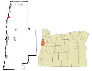
Lincoln Beach is a census-designated place (CDP) in Lincoln County, Oregon, United States. It includes the unincorporated communities of Lincoln Beach and Gleneden Beach. The total population was 2,045 at the 2010 census.

Milroy is a census-designated place (CDP) that is located in the Kishacoquillas Valley of Mifflin County, Pennsylvania, United States. The population was 1,386 at the time of the 2000 census.

<span class="mw-page-title-main">Donaldson, Pennsylvania</span> CDP in Pennsylvania, United States

Donaldson is a census-designated place (CDP) in Frailey Township, Schuylkill County, Pennsylvania, United States. The population was 325 at the 2000 census.

<span class="mw-page-title-main">Mount Pleasant Mills, Pennsylvania</span> CDP in Pennsylvania, United States

Mount Pleasant Mills is a census-designated place (CDP) in Snyder County, Pennsylvania, United States. The population was 342 at the 2000 census.

Larga Vista is a former census-designated place (CDP) in Webb County, Texas, United States. The population was 742 at the 2000 census. Larga Vista lost its census-designated place status in 2010 because it became surrounded by Laredo. A CDP may not be located, either partially or entirely, within an incorporated place or another CDP. Today, Larga Vista is considered a Laredo neighborhood.

<span class="mw-page-title-main">Merrifield, Virginia</span> Census-designated place in Virginia, United States

Merrifield is a census-designated place (CDP) in Fairfax County, Virginia, United States. The population was 20,488 at the 2020 census.

<span class="mw-page-title-main">Chamberlayne, Virginia</span> Census-designated place in Virginia

Chamberlayne is a census-designated place (CDP) in Henrico County, Virginia, United States. The population was 5,581 at the 2020 census.

<span class="mw-page-title-main">Loch Lomond, Virginia</span> Census-designated place in Virginia, United States

Loch Lomond is a census-designated place (CDP) in Prince William County, Virginia, United States. The population was 3,701 at the 2010 census. It is named after a loch in northern Scotland, Loch Lomond.

<span class="mw-page-title-main">Sudley, Virginia</span> Census-designated place in Virginia, United States

Sudley is a census-designated place (CDP) in Prince William County, Virginia, United States. As of the 2010 census, Sudley comprises what in the 2000 census were the Sudley and West Gate CDPs. Sudley's population including West Gate was 16,203 at the 2010 census, and excluding West Gate was 7,719 at the 2000 census.

<span class="mw-page-title-main">West Gate, Prince William County, Virginia</span> Unincorporated community & Former Census-designated place in Virginia, United States

West Gate is an unincorporated community and former census-designated place (CDP) in Prince William County, Virginia, United States. The population was 7,493 at the 2000 census. It contained the now-defunct Sunnybrook Golf Club.

<span class="mw-page-title-main">Spotsylvania Courthouse, Virginia</span> Unincorporated census-designated place in Virginia, United States

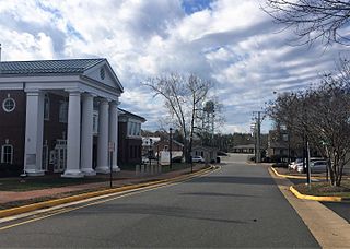
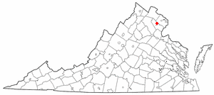
Spotsylvania Courthouse is a census-designated place (CDP) and the county seat of Spotsylvania County, Virginia, United States, located 10 miles (16 km) southwest of Fredericksburg. Recognized by the U.S. Census Bureau as a census designated place (CDP), the population was 5,610 at the 2020 census.

<span class="mw-page-title-main">Emory-Meadowview, Virginia</span> Former CDP in Virginia, United States

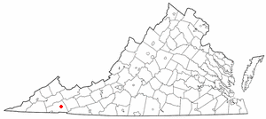
Emory-Meadowview was a census-designated place (CDP) in Washington County, Virginia, United States. The population was 2,266 at the 2000 census. It is part of the Kingsport–Bristol (TN)–Bristol (VA) Metropolitan Statistical Area, which is a component of the Johnson City–Kingsport–Bristol, TN-VA Combined Statistical Area – commonly known as the "Tri-Cities" region. As of the 2010 census it was split into Emory and Meadow View CDPs.

North Rock Springs is a census-designated place (CDP) in Sweetwater County, Wyoming, United States. The population was 2,439 at the 2020 census.

References

  1. 1 2 "U.S. Census website". United States Census Bureau . Retrieved January 31, 2008.
  2. "US Board on Geographic Names". United States Geological Survey. October 25, 2007. Retrieved January 31, 2008.
  3. "US Gazetteer files: 2010, 2000, and 1990". United States Census Bureau. February 12, 2011. Retrieved April 23, 2011.